The Harmed Success Stories Concepts How To What Is Commentary
Fayette County Marcellus Shale Permits 6/1/20 - 6/14/20
Contents
Pennsylvania Bulletin Listings
Uniontown Compressor Station Synthetic Minor Operating Permit renewaleFACTS Listings
Shamrock Compressor Station Minor Facility Plan Approval New Source Performance Std Extension
COTTOM LEONARD PIPELINE STREAM CROSSING GP-05 Utility Line Stream Crossings (New)
ENERGY RESOURCES LOCK 8 Intake Structure GP-04 Intake & Outfall Structures (New)
Yoder Well Connect Pipeline Project PAG-10 Discharge Resulting from Hydrostatic Testing of Tanks & Pipelines Rescission (New)
JEANETTE GLASS 70 Drill & Operate Well Permit Adoption Issued 5/27/2020
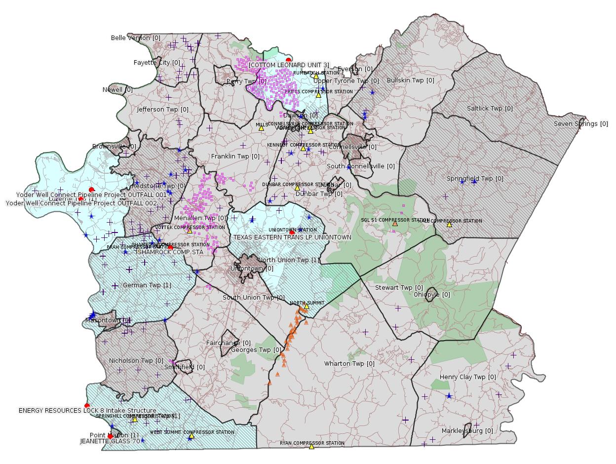
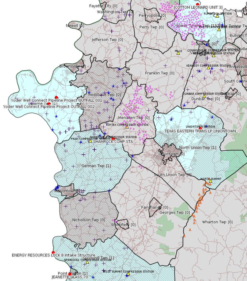
Map
Key
Red dots: items in this permit list with an exact location.
Blue stars: Marcellus Gas Well Water Sources.
Where well laterals are mapped they show in red; a 400-foot buffer surrounding the lateral shows in blue (lavender where it overlaps a mapped mineral tract).
Where mineral tracts are mapped, they show in pink. Mineral tracts can overlap; the overlap will show in red. The precise meaning of "mineral tract" is not clear.
Municipality shading: number of "facilities", with each well counting separately
(includes the red dots):
gray: 0
pale turquoise: 1
turquoise: 2
pale blue: 3
middle blue: 4
dark blue: 5
dark purple: 6
purple: 18
(Color coding may differ from one issue to the next.)
(Note if a project spans multiple municipalities -- e.g. a pipeline -- it will show in the count for each municipality.)
The number of facilities also follows the municipality name in brackets.
Municipality counts are based on the way the permit is listed by DEP; DEP has been known to get a municipality wrong.
Locations in brackets identify a precise location used to locate a surrogate for the actual site being permitted (e.g. locating a well pad or pipeline by the known location of a well.) Locations labeled beginning with "~" and ending in "[?]" are approximate and speculative based on inferences using on-line property and lease records. These are marked in the text as "[Approximate, Speculative]
Cross-hatching: Environmental Justice Areas
Yellow triangles: Compressor Stations
Orange triangles: Storage Field Wells (currently Dominion North Summit Storage Field)
Crosses: SPUD Unconventional well permits
Green: "Natural areas", e.g. state game lands, state forests
Yellow triangles: Compressor Stations
Orange triangles: Storage Field Wells (currently Dominion North Summit Storage Field)
Crosses: SPUD Unconventional well permits
Green: "Natural areas", e.g. state game lands, state forests
More Maps
 |
Source: Pennsylvania Bulletin
26-00413: Texas Eastern Transmission, L.P. (5400 Westheimer Ct, Houston, TX 77056-5353). In accordance with 25 Pa. Code §§ 127.424, 127.425 and 127.521, the Department is providing notice that it intends to issue a renewal Synthetic Minor Operating Permit for operation of the Uniontown Compressor Station located in North Union Township, Fayette County.
The facility operates two (2) natural gas-fired turbines, two (2) stationary reciprocating internal combustion engines driving emergency electric generators, area fugitive VOC emissions, two (2) pipeline liquid storage tanks, and gas release events. Insignificant emission sources include several small natural gas-fired heaters, separator vessels ranging in size from 33 to 470 gallons, three (3) small miscellaneous storage tanks, a truck loading area, and a remote reservoir parts washer.
Potential emissions for the facility have been calculated as follows: 47.63 tons per year of carbon monoxide (CO), 86.44 tons per year of nitrogen oxides (NOx), 5.77 tons per year of particulate matter less than 10-microns (PM10), 5.77 tons per year of particulate matter less than 2.5-microns (PM2.5), 12.08 tons per year of sulfur oxides (SO2), 44.99 tons per year of volatile organic compounds (VOC), 0.39 ton per year of benzene, 0.71 ton per year of formaldehyde, 0.85 ton per year of hexane, 3.28 tons per year of Hazardous Air Pollutants (HAP), and 131,854 tons per year of greenhouse gases (GHGs).
The facility is subject to the applicable requirements of 25 Pa. Code Article III, Chapters 121—145. The proposed operating permit includes emission limitations, monitoring, work practice standards, reporting, and recordkeeping requirements for the facility.
The application, DEP's Review Memorandum, and the proposed permit are available for public review during normal business hours at DEP's Southwest Regional Office, 400 Waterfront Drive, Pittsburgh, PA 15222. A file review can be scheduled through the DEP's website at https://www.dep.pa.gov/Citizens/PublicRecords/Pages/Informal-File-Review.aspx.
Any person may submit comments, a request for the Department to hold a public hearing, or a protest to the proposed operating permit or a condition thereof by submitting the information to Nick Waryanka, P.E., Air Quality Engineer, at the Southwest Regional Office. A 30-day comment period from the date of publication of this notice will exist for the submission of comments. Each written comment must contain the name, address and telephone number of the person submitting the comments, identification of the proposed permit (specify Operating Permit 26-00413) and concise statements regarding the relevancy of the information in the proposed permit or objections to issuance of the permit.
A public hearing may be held in accordance with 25 Pa. Code § 127.429, if the Department, in its discretion, decides that such a hearing is warranted based on the information received. If a public hearing is held, all persons who have properly filed a protest under 25 Pa. Code § 127.426 may appear and give testimony. The applicant, the protestant, and other participants will be notified of the decision to hold a hearing (and the time, place and purpose of such hearing) by publication in the newspaper or by the Pennsylvania Bulletin, or by telephone, where the Department determines such notification by telephone is sufficient.
<http://www.pacodeandbulletin.gov/Display/pabull?file=/secure/pabulletin/data/vol50/50-23/739a.html&continued=http://www.pacodeandbulletin.gov/Display/pabull?file=/secure/pabulletin/data/vol50/50-23/739.html&d=>
Deadline for Public Comment: 7/6/2020
Location: 39.93111,-79.67
Map URL: <https://www.openstreetmap.org/?mlat=39.93111&mlon=-79.67#map=15/39.93111/-79.67>
Presumed Parcel Id: 25120168
Map URL: <https://www.openstreetmap.org/?mlat=39.93111&mlon=-79.67#map=15/39.93111/-79.67>
Presumed Parcel Id: 25120168
---
26-00588B: Laurel Mountain Midstream Operating, LLC (Park Place Corporate Center 2, 2000 Commerce Drive, Pittsburgh, PA 15275) extension effective May 28, 2020, to extend the period of installation and continued temporary operation of three (3) compressor engines, two (2) gas-fired turbines, one (1) emergency generator, two (2) dehydrators, two (2) reboilers, one (1) glycol processing unit, and five (5) produced water storage tanks authorized under plan approval PA-26-00588B, until November 28, 2020, at Shamrock Compressor Station located in German Township, Fayette County.
<http://www.pacodeandbulletin.gov/Display/pabull?file=/secure/pabulletin/data/vol50/50-23/739e.html&continued=http://www.pacodeandbulletin.gov/Display/pabull?file=/secure/pabulletin/data/vol50/50-23/739.html&d=reduce>
Location: 39.918333,-79.825
Map URL: <http://www.openstreetmap.org/?mlat=39.918333&mlon=-79.825#map=15/39.918333/-79.825>
Parcel ID: 15140026
Map URL: <http://www.openstreetmap.org/?mlat=39.918333&mlon=-79.825#map=15/39.918333/-79.825>
Parcel ID: 15140026
-------------------------
Source: eNOTICE
(+ PA
Oil and Gas Mapping, Well
Pad Report.) Well Details via Data
Portal Services: Oil and Gas Wells All (ID: 3).
Please see the Disclaimer below regarding Parcel Id data.
Authorization ID: 1317063
Permit number: GP052607220-024
Site: COTTOM LEONARD PIPELINE STREAM CROSSING
Client: APOLLO RESOURCES LLC
Authorization type: GP-05 Utility Line Stream Crossings
Application type: New
Authorization is for: FACILITY
Date received: 06/10/2020
Status: Pending
Permit Decision Guarantee Applies?: Yes
Permit Decision Guarantee status: ACTIVE
Permit Review Notes:
Date Review Note
6/12/2020 The permit application package is complete, has been accepted, and is undergoing technical review.
<https://www.ahs.dep.pa.gov/eFACTSWeb/searchResults_singleAuth.aspx?AuthID=1317063>
Site Programs:
Water Planning and Conservation
Site Municipalities:
Lower Tyrone Twp, Fayette County
Location [of COTTOM LEONARD UNIT 3]: 40.100551,-79.6712
[See Notes.]
---
Authorization ID: 1316371
Permit number: GP042605220-023
Site: ENERGY RESOURCES LLC FAYETTE CNTY
Client: ENERGY RESOURCES LLC
Authorization type: GP-04 Intake & Outfall Structures
Application type: New
Authorization is for: FACILITY
Date received: 06/04/2020
Status: Pending
Permit Decision Guarantee Applies?: No
Sub-Facilities for Authorization:
Sub-Facility ID Sub-Facility Name Description
1309552 LOCK 8 Intake Structure
Location: 39.7644,-79.9333
Map URL: <http://www.openstreetmap.org/?mlat=39.7644&mlon=-79.9333#map=15/39.7644/-79.9333>
<https://www.ahs.dep.pa.gov/eFACTSWeb/searchResults_singleAuth.aspx?AuthID=1316371>
Site Programs:
Water Planning and Conservation
Site Municipalities:
Springhill Twp, Fayette County
Presumed Parcel Id: 36060008
---
Authorization ID: 1315971
Permit number: PAG106222
Site: Yoder Well Connect Pipeline Project
Client: LAUREL MTN MIDSTREAM OPR LLC
Authorization type: PAG-10 Discharge Resulting from Hydrostatic Testing of Tanks & Pipelines
Application type: Rescission
Authorization is for: FACILITY
Date received: 06/01/2020
Status: Pending
Permit Decision Guarantee Applies?: No
Sub-Facilities for Authorization:
Sub-Facility ID Sub-Facility Name Description
1291629 OUTFALL 001 Discharge Point
Location: 39.976094,-79.924633
Map URL: <http://www.openstreetmap.org/?mlat=39.976094&mlon=-79.924633#map=15/39.976094/-79.924633>
1291630 OUTFALL 002 Discharge Point
Location: 39.967828,-79.938114
Map URL: <http://www.openstreetmap.org/?mlat=39.967828&mlon=-79.938114#map=15/39.967828/-79.938114>
<https://www.ahs.dep.pa.gov/eFACTSWeb/searchResults_singleAuth.aspx?AuthID=1315971>
Site Programs:
Clean Water
Water Planning and Conservation
Site Municipalities:
Luzerne Twp, Fayette County
Presumed Parcel Id: 19160034 (Outfall 001)
Presumed Parcel Id: 19250012 (Outfall 002)
---
Authorization ID: 1315353
Permit number: 051-24720
Site: JEANETTE GLASS 70
Client: NOUMENON CORP
Authorization type: Drill & Operate Well Permit Adoption
Application type: New
Authorization is for: FACILITY
Date received: 05/04/2020
Status: Issued on 5/27/2020
Permit Decision Guarantee Applies?: No
Sub-Facilities for Authorization:
Sub-Facility ID Sub-Facility Name Description
1308955 JEANETTE GLASS 70 Well
Permit Review Notes:
Date Review Note
5/27/2020 The technical review and decision review are complete and either the permit decision and/or permit issuance are forthcoming.
5/27/2020 The permit application package is complete, has been accepted, and is undergoing technical review.
<https://www.ahs.dep.pa.gov/eFACTSWeb/searchResults_singleAuth.aspx?AuthID=1315353>
Site Programs:
Oil & Gas
Site Municipalities:
Springhill Twp, Fayette County [Incorrect -- should be Point Marion Borough -jr]
Well Details:
Permit Number: 051-24720
Well Name: JEANETTE GLASS 70
Unconventional Well: N
Well Configuration: Vertical Well
Well Type: GAS
Well Status: Active
Coal Association: NonCoal
Conservation Well: N
Primary Facility ID: 842391
Site ID: 843098
Site Name: JEANETTE GLASS 70
Well Pad ID: 0
Well Pad Name:
Storage Field:
Operator: NOUMENON CORP
Operator Number: OGO-35584
Permit Date: 2020-05-27
Permit Date Expires:
SPUD Date:
Date Plugged:
UIC ID:
UIC Type:
Surface Elevation: 0
County: Fayette
Municipality: Springhill Twp [Incorrect -- should be Point Marion Borough -jr]
Location: 39.734464,-79.904528
Map URL: <http://www.openstreetmap.org/?mlat=39.734464&mlon=-79.904528#map=15/39.734464/-79.904528>
OG WELLS PERMIT DOCS:
2020-05-27: Initial Submitted Documents, Name: 051-24720 ADDOW approval (for Authorization: 1315353):
<http://www.depgis.state.pa.us/pdfHandler/pdFHandler.ashx?Doc=MTI0NTA4Nw==&ext=PDF>
-------------------------
Please see the Disclaimer below regarding Parcel Id data.
Authorization ID: 1317063
Permit number: GP052607220-024
Site: COTTOM LEONARD PIPELINE STREAM CROSSING
Client: APOLLO RESOURCES LLC
Authorization type: GP-05 Utility Line Stream Crossings
Application type: New
Authorization is for: FACILITY
Date received: 06/10/2020
Status: Pending
Permit Decision Guarantee Applies?: Yes
Permit Decision Guarantee status: ACTIVE
Permit Review Notes:
Date Review Note
6/12/2020 The permit application package is complete, has been accepted, and is undergoing technical review.
<https://www.ahs.dep.pa.gov/eFACTSWeb/searchResults_singleAuth.aspx?AuthID=1317063>
Site Programs:
Water Planning and Conservation
Site Municipalities:
Lower Tyrone Twp, Fayette County
Location [of COTTOM LEONARD UNIT 3]: 40.100551,-79.6712
[See Notes.]
---
Authorization ID: 1316371
Permit number: GP042605220-023
Site: ENERGY RESOURCES LLC FAYETTE CNTY
Client: ENERGY RESOURCES LLC
Authorization type: GP-04 Intake & Outfall Structures
Application type: New
Authorization is for: FACILITY
Date received: 06/04/2020
Status: Pending
Permit Decision Guarantee Applies?: No
Sub-Facilities for Authorization:
Sub-Facility ID Sub-Facility Name Description
1309552 LOCK 8 Intake Structure
Location: 39.7644,-79.9333
Map URL: <http://www.openstreetmap.org/?mlat=39.7644&mlon=-79.9333#map=15/39.7644/-79.9333>
<https://www.ahs.dep.pa.gov/eFACTSWeb/searchResults_singleAuth.aspx?AuthID=1316371>
Site Programs:
Water Planning and Conservation
Site Municipalities:
Springhill Twp, Fayette County
Presumed Parcel Id: 36060008
---
Authorization ID: 1315971
Permit number: PAG106222
Site: Yoder Well Connect Pipeline Project
Client: LAUREL MTN MIDSTREAM OPR LLC
Authorization type: PAG-10 Discharge Resulting from Hydrostatic Testing of Tanks & Pipelines
Application type: Rescission
Authorization is for: FACILITY
Date received: 06/01/2020
Status: Pending
Permit Decision Guarantee Applies?: No
Sub-Facilities for Authorization:
Sub-Facility ID Sub-Facility Name Description
1291629 OUTFALL 001 Discharge Point
Location: 39.976094,-79.924633
Map URL: <http://www.openstreetmap.org/?mlat=39.976094&mlon=-79.924633#map=15/39.976094/-79.924633>
1291630 OUTFALL 002 Discharge Point
Location: 39.967828,-79.938114
Map URL: <http://www.openstreetmap.org/?mlat=39.967828&mlon=-79.938114#map=15/39.967828/-79.938114>
<https://www.ahs.dep.pa.gov/eFACTSWeb/searchResults_singleAuth.aspx?AuthID=1315971>
Site Programs:
Clean Water
Water Planning and Conservation
Site Municipalities:
Luzerne Twp, Fayette County
Presumed Parcel Id: 19160034 (Outfall 001)
Presumed Parcel Id: 19250012 (Outfall 002)
---
Authorization ID: 1315353
Permit number: 051-24720
Site: JEANETTE GLASS 70
Client: NOUMENON CORP
Authorization type: Drill & Operate Well Permit Adoption
Application type: New
Authorization is for: FACILITY
Date received: 05/04/2020
Status: Issued on 5/27/2020
Permit Decision Guarantee Applies?: No
Sub-Facilities for Authorization:
Sub-Facility ID Sub-Facility Name Description
1308955 JEANETTE GLASS 70 Well
Permit Review Notes:
Date Review Note
5/27/2020 The technical review and decision review are complete and either the permit decision and/or permit issuance are forthcoming.
5/27/2020 The permit application package is complete, has been accepted, and is undergoing technical review.
<https://www.ahs.dep.pa.gov/eFACTSWeb/searchResults_singleAuth.aspx?AuthID=1315353>
Site Programs:
Oil & Gas
Site Municipalities:
Springhill Twp, Fayette County [Incorrect -- should be Point Marion Borough -jr]
Well Details:
Permit Number: 051-24720
Well Name: JEANETTE GLASS 70
Unconventional Well: N
Well Configuration: Vertical Well
Well Type: GAS
Well Status: Active
Coal Association: NonCoal
Conservation Well: N
Primary Facility ID: 842391
Site ID: 843098
Site Name: JEANETTE GLASS 70
Well Pad ID: 0
Well Pad Name:
Storage Field:
Operator: NOUMENON CORP
Operator Number: OGO-35584
Permit Date: 2020-05-27
Permit Date Expires:
SPUD Date:
Date Plugged:
UIC ID:
UIC Type:
Surface Elevation: 0
County: Fayette
Municipality: Springhill Twp [Incorrect -- should be Point Marion Borough -jr]
Location: 39.734464,-79.904528
Map URL: <http://www.openstreetmap.org/?mlat=39.734464&mlon=-79.904528#map=15/39.734464/-79.904528>
OG WELLS PERMIT DOCS:
2020-05-27: Initial Submitted Documents, Name: 051-24720 ADDOW approval (for Authorization: 1315353):
<http://www.depgis.state.pa.us/pdfHandler/pdFHandler.ashx?Doc=MTI0NTA4Nw==&ext=PDF>
Parcel Id: 29030003
-------------------------
There is a huge discrepancy between the PA Bulletin listing above for the Uniontown Compressor Station and the last entry for this facility in eFACTS. Apparently what is going on here is that Texas Eastern is applying under two authorizations at the same time: one for a renewal of an older permit, and one for an amendment. The eFACTS listing for the "renewal" currently shows:
Authorization ID: 1295805
Permit number: 26-00413
Site: TEXAS EASTERN TRANS LP UNIONTOWN
Client: TEXAS EASTERN TRANS LP
Authorization type: Minor Source Operating Permit
Application type: New
Authorization is for: FACILITY
Date received: 11/12/2019
Status: Pending
Permit Decision Guarantee Applies?: No
Sub-Facilities for Authorization:
Sub-Facility ID Sub-Facility Name Description
492648 AREA FUGITIVES & STORAGE TANK 2 Process
492650 DRY LOW-NOX COMBUSTORS TURBINE 1 Air Pollution Control Device
492651 DRY LOW-NOX COMBUSTORS TURBINE 2 Air Pollution Control Device
954278 EMERGENCY GENERATOR 440 BHP Process
492647 EMERGENCY GENERATOR ENGINE 600 BHP Process
1006475 GAS RELEASE EVENTS Process
247442 TURBINE T1 Process
1123964 TURBINE T1 OXIDATION CATALYST Air Pollution Control Device
247443 TURBINE T2 Process
1123965 TURBINE T2 OXIDATION CATALYST Air Pollution Control Device
Permit Review Notes:
Date Review Note
11/14/2019 The permit application package is complete, has been accepted, and is undergoing technical review.
<https://www.ahs.dep.pa.gov/eFACTSWeb/searchResults_singleAuth.aspx?AuthID=1295805>
Site Programs:
Air Quality
Waste Management
Site Municipalities:
North Union Twp, Fayette County
Uniontown, Fayette County
The "renewal" is for a minor source but the new one shows as being for a Major Source. Note that both authorizations show the same permit number. This is contrary to DEP's usual practice of "incrementing" a letter suffix every time a permit is modified. On 10/6/2014, DEP issued permit # 26-00413B for this facility. So WHY is permit number 26-00413 still being used???
All very confusing ...
Historical note: this facility was the subject of a lawsuit in the United States District Court for the Western District of Pennsylvania, Docket # 13cv1197, by nearby resident, Thomas Koziel who alleged his hearing was damaged by an uncontrolled release of gas.
---
Apollo Resources LLC appears to have bought out the Range Resources wells (all but one conventional) in Fayette County. Well details for COTTOM LEONARD UNIT 3 show:
Well Details:
Permit Number: 051-23594
Well Name: COTTOM LEONARD UNIT 3
Unconventional Well: N
Well Configuration: Vertical Well
Well Type: GAS
Well Status: Active
Coal Association: Coal
Conservation Well: N
Primary Facility ID: 691839
Site ID: 687248
Site Name: COTTOM LEONARD UNIT 3 OG WELL
Well Pad ID: 0
Well Pad Name:
Storage Field:
Operator: APOLLO RESOURCES LLC
Operator Number: OGO-39623
Permit Date: 2007-04-19
Permit Date Expires: 2008-04-19
SPUD Date: 2007-07-19
Date Plugged:
UIC ID:
UIC Type:
Surface Elevation: 1300
County: Fayette
Municipality: Lower Tyrone Twp
Location: 40.100551,-79.6712
Map URL: <http://www.openstreetmap.org/?mlat=40.100551&mlon=-79.6712#map=15/40.100551/-79.6712>
Not clear why 13 years after this well was SPUD, Apollo is building a pipeline near here.
Note: The purple squares on the maps for this issue show the locations of the Apollo wells.
------------------------
<https://www.dep.pa.gov/PublicParticipation/OfficeofEnvironmentalJustice/Pages/default.aspx>). There are supposed to be enhanced public participation requirements for permits in environmental justice areas, but news of this actually ever happening is scarce. In Fayette County, the entirety of Redstone, Springhill, Nicholson, and German Townships are environmental justice areas, as well as a large part of Dunbar Township. DEP's policy document on public participation guidelines for environmental justice areas is located here:
<https://www.elibrary.dep.state.pa.us/dsweb/Get/Version-48671/012-0501-002.pdf>
eNOTICE records are likely to list the same permit multiple times, as that permit moves through the DEP process.
Oil & Gas Wells designated with a site a number and the letter H typically designate horizontal wells.
-------------------------
Resources:
Pennsylvania Bulletin: <https://www.pabulletin.com/>
eNOTICE: <https://www.ahs2.dep.state.pa.
DEP Oil and Gas Reports: <https://www.dep.pa.gov/DataandTools/Reports/Oil%20and%20Gas%20Reports/Pages/default.aspx>
DEP Permits Issued Detail Report:
<https://www.depreportingservic
DEP SPUD (drilling started) Report:
<https://www.depreportingservices.state.pa.us/ReportServer/Pages/ReportViewer.aspx?/Oil_Gas/Spud_External_Data>
DEP Oil and Gas Compliance Report:
<https://www.depreportingservices.state.pa.us/ReportServer/Pages/ReportViewer.aspx?/Oil_Gas/OG_Compliance>
DEP PA Oil & Gas Mapping:
<https://www.depgis.state.pa.us/PaOilAndGasMapping>
Data Portal Services Directory [Technical]
<https://www.depgis.state.pa.us/arcgis/rest/services>
Query: Oil and Gas Wells All (ID: 3) [Technical]:
<https://www.depgis.state.pa.us/arcgis/rest/services/OilGas/OilGasAllStrayGasEGSP/MapServer/3/query?where=&text=&objectIds=&time=&geometry=&geometryType=esriGeometryEnvelope&inSR=&spatialRel=esriSpatialRelIntersects&relationParam=&outFields=*&returnGeometry=true&returnTrueCurves=false&maxAllowableOffset=&geometryPrecision=&outSR=&returnIdsOnly=false&returnCountOnly=false&orderByFields=&groupByFieldsForStatistics=&outStatistics=&returnZ=false&returnM=false&gdbVersion=&returnDistinctValues=false&resultOffset=&resultRecordCount=&f=html>
(Be sure to enter a Where clause in SQL format. Dates are in milliseconds since midnight 1/1/1970).
DEP Oil and Gas Electronic Submissions
<https://www.ahs.dep.pa.gov/eSubmissionPublicSearch>
DEP Oil and Gas Electronic Notifications
<https://www.depreportingservices.state.pa.us/ReportServer?/Oil_Gas/OG_Notifications>
DEP Oil and Gas Well Pad Report
<https://www.depreportingservices.state.pa.us/ReportServer?/Oil_Gas/Well_Pads>
Fayette County Assessment Office Search For Tax Records:
<http://property.co.fayette.pa.us/search.aspx>
Pennsylvania Spatial Data Access:
<https://www.pasda.psu.edu/default.asp>
DEP Spatial Data Repository:
<ftp://www.pasda.psu.edu/pub/pasda/dep/>
National Response Center:
<https://www.nrc.uscg.mil/>
EPA-Echo: <https://www.epa-echo.gov/echo/
FERC citizen involvement: <https://www.ferc.gov/for-citiz
To receive E-mail notification of
all documents filed in a FERC docket, see:
<https://www.ferc.gov/docs-filing/esubscription.asp >
<https://www.ferc.gov/docs-fili
Follow the directions and enter the docket number to subscribe to.
Township Supervisors receive information regarding Erosion & Sedimentation permits, and these records may be reviewable at township municipal offices.
DEP permits are reviewable through the File Review process, for application to do file review see: <https://www.portal.state.pa.us/portal/server.pt/community/southwest_regional_office/13775/file_review/593164>
Environmental Hearing Board: <https://ehb.courtapps.com/publ
PA DEP Environmental Policy Comment System:
<https://www.ahs.dep.pa.gov/eComment/>
Federal Register Environment: <https://www.federalregister.g
Browsing of recent comment
opportunities for federal agencies, e.g. EPA. Click "sign up" to
subscribe to daily E-mails of new document listings.
SkyTruth Fayette County Drilling Alerts: <https://frack.skytruth.org/pen
U.S. Army Corps of Engineers, Pittsburgh District, Public Notices:
<https://www.lrp.usace.army.mil/Missions/Regulatory/Public-Notices/>
EPA Pennsylvania Public Notices: <https://www2.epa.gov/aboutepa/epa-pennsylvania#notice>
Marcellus Shale waste disposal
injection wells in Pennsylvania are regulated directly by EPA, not
DEP. Notice of any new permit applications will appear at the
above web address. I'm not aware of any subscription service
to be notified of such applications. I'm not aware of any
Marcellus Shale waste disposal injection wells in Fayette County
(yet ...) but we need to monitor this page for future
applications.
Energy Assurance Daily: <https://www.oe.netl.doe.gov/ead.aspx>
Daily newsletter from the US
Department of Energy about events relating to energy. The Natural
Gas section has information about pipelines.
-------------------------
Disclaimers:
This compilation from the above sources was done in part by hand using copy and paste and in part using automated methods; it may omit relevant permits.
Parcel data is provided via the tax records search web page offered by the Fayette County Assessment Office (http://property.co.fayette.pa.us/). Presumed Parcel Id links are subject to availability provided by that agency and associated web sites. Presumed Parcel Ids are determined as the mapped parcel containing a given latitude and longitude, are a best effort determination which is subject to error, and are not official. In cases where a facility is leased and there is a separate parcel id for the lease, if this parcel id is not separately mapped, the parcel id shown will be the id for the enclosing parcel. Parcel owners may be surface owners only and may or may not have any relationship to oil & gas facilities.
Does not currently include water supply permits. Does not include landfill permits even though many such are for Marcellus Shale waste. (It is not possible at this time to distinguish which landfill permits are for Marcellus Shale waste and which are not without doing File Review for each permit.)
Erosion & Sedimentation permit records do not currently include latitude and longitude. Where I am publishing latitude and longitude with E&S permits it is by inferring an associated well permit and using published latitude and longitude for the well. It is possible I may be inferring the wrong well site.
Municipalities are shown from eFACTS records on the DEP web site. The DEP has been known to list a municipality incorrectly.