The Harmed Success Stories Concepts How To What Is Commentary
Fayette County Marcellus Shale Permits 6/14/21 - 6/27/21
Contents
Pennsylvania Bulletin Listings
Pennsylvania 2021 Annual Ambient Air Monitoring Network PlaneFACTS Listings
WEST SUMMIT COMP STA AQ GP 5A - Unconventional Natural Gas Well Site Operations
FAYETTE ENERGY FAC TRTMT PLT Water Quality Mgmt Part II, Industrial Wastewater Fac Transfer
DYNEGY FAYETTE II LLC Major Facility Operating Permit Renewal
SIEGEL 3H Casing cementing notification Production Casing: 6/26/2021
SIEGEL 2H Drilling resumption After Break of 30 days or more 06/26/2021
Inspection
Issues
Price of Natural GasLUDROSKY UNIT 1 Incident- Response to Accident or Event; leak at the gathering line; Violation(s) Noted
MILLER 42 Complaint Inspection; E&S Issues with stability of the access road; Violation(s) Noted
MILLER 43 Complaint Inspection; Brine Tank Release; Violation(s) Noted
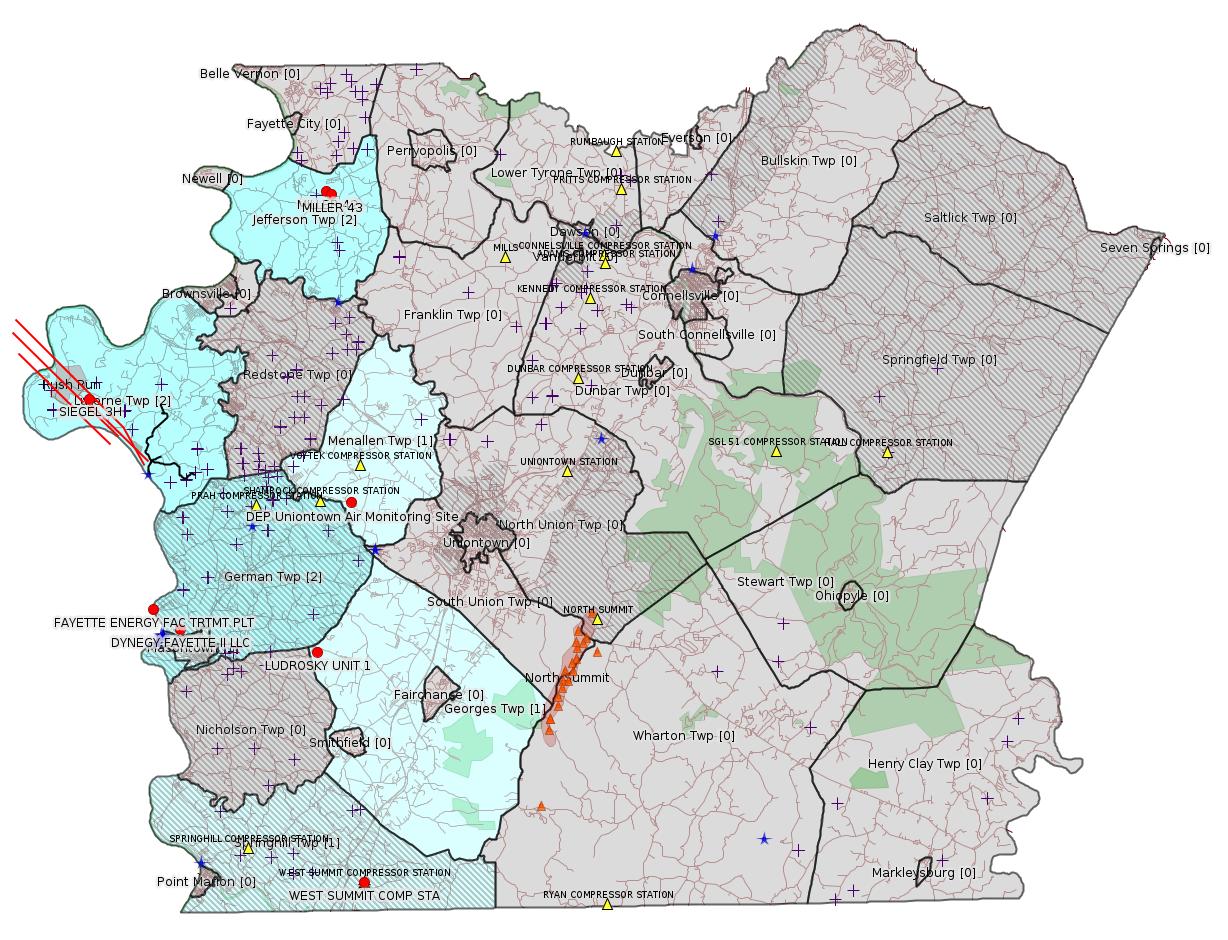
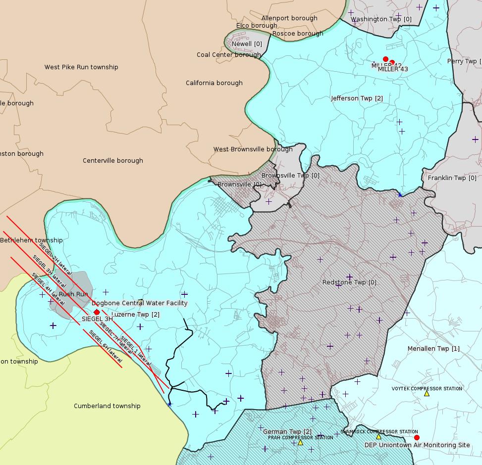
Map
Key
Red dots: items in this permit list with an exact location.
Blue stars: Marcellus Gas Well Water Sources.
Where well laterals are mapped they show in red; a 400-foot buffer surrounding the lateral shows in blue (lavender where it overlaps a mapped mineral tract).
Where mineral tracts are mapped, they show in pink. Mineral tracts can overlap; the overlap will show in red. The precise meaning of "mineral tract" is not clear.
Municipality shading: number of "facilities", with each well counting separately
(includes the red dots):
gray: 0
pale turquoise: 1
turquoise: 2
pale blue: 3
middle blue: 4
dark blue: 5
dark purple: 7
purple: 9
(Color coding may differ from one issue to the next.)
(Note if a project spans multiple municipalities -- e.g. a pipeline -- it will show in the count for each municipality.)
The number of facilities also follows the municipality name in brackets.
Municipality counts are based on the way the permit is listed by DEP; DEP has been known to get a municipality wrong.
Locations in brackets identify a precise location used to locate a surrogate for the actual site being permitted (e.g. locating a well pad or pipeline by the known location of a well.) Locations labeled beginning with "~" and ending in "[?]" are approximate and speculative based on inferences using on-line property and lease records. These are marked in the text as "[Approximate, Speculative]
Cross-hatching: Environmental Justice Areas
Yellow triangles: Compressor Stations
Orange triangles: Storage Field Wells (currently Dominion North Summit Storage Field)
Crosses: SPUD Unconventional well permits
Green: "Natural areas", e.g. state game lands, state forests
Yellow triangles: Compressor Stations
Orange triangles: Storage Field Wells (currently Dominion North Summit Storage Field)
Crosses: SPUD Unconventional well permits
Green: "Natural areas", e.g. state game lands, state forests
More Maps
 |
Source: Pennsylvania Bulletin
NOTICES
DEPARTMENT OF
ENVIRONMENTAL PROTECTION
Pennsylvania's 2021 Annual Ambient Air Monitoring Network Plan
[51 Pa.B. 3395]
[Saturday, June 19, 2021]
The Department of Environmental Protection (Department) is seeking public comment on Pennsylvania's 2021 Annual Ambient Air Monitoring Network Plan (Plan). The Plan has been updated to address changes that have been made in the Commonwealth's ambient air monitoring network and to identify anticipated changes in the remainder of 2021 and in 2022.
On October 17, 2006, the United States Environmental Protection Agency (EPA) promulgated final amendments to the National ambient air monitoring requirements for criteria pollutants at 40 CFR Parts 53 and 58 (relating to ambient air monitoring reference and equivalent methods; and ambient air quality surveillance). See 71 FR 61236 (October 17, 2006). The EPA's final rule requires state and local agencies to enhance air monitoring to ''improve public health protection and better inform the public about air quality in their communities.'' Under 40 CFR 58.10 (relating to annual monitoring network plan and periodic network assessment), air quality state and local monitoring agencies must adopt an annual air monitoring network plan and make the plan available for public inspection for at least 30 days prior to final submission to the EPA Regional Administrator. The Plan, which is due July 1, 2021, must include a statement of purpose for each monitor and evidence that siting and operation of each monitor meets Federal requirements. The EPA may also provide an opportunity for review and comment prior to approving or disapproving a state's monitoring network plan.
The Plan is available on the Department's web site at www.dep.pa.gov/Business/Air/BAQ/Pages/default.aspx.
The Department must receive comments no later than Monday, July 19, 2021. Commentators are encouraged to submit comments using the Department's online eComment tool at www.ahs.dep.pa.gov/eComment or by e-mail to ecomment@pa.gov. Comments submitted by facsimile will not be accepted. All comments, including comments submitted by e-mail, must include the commentator's name and address. Written comments can be mailed to the Policy Office, Department of Environmental Protection, Rachel Carson State Office Building, P.O. Box 2063, Harrisburg, PA 17105-2063. Use ''2021 Annual Monitoring Network Plan'' as the subject line in written communication.
PATRICK McDONNELL,
Secretary
<http://www.pacodeandbulletin.gov/Display/pabull?file=/secure/pabulletin/data/vol51/51-25/958.html>
[See Notes.]
-------------------------
Please see the Disclaimer below regarding Parcel Id data.
Authorization ID: 1354909
Permit number: AG5A-26-00001A
Site: WEST SUMMIT COMP STA
Client: INR OPR LLC
Authorization type: AQ GP 5A - Unconventional Natural Gas Well Site Operations
Application type: New
Authorization is for: FACILITY
Date received: 03/27/2021
Status: Pending
Permit Decision Guarantee Applies: No
Sub-Facilities for Authorization:
Sub-Facility ID Sub-Facility Name Description
1049057 GLYCOL DEHYS UNIT 2 Process
1186826 VENTING/BLOWDOWNS Process
1186820 TANKS/VESSELS Process
1025060 CATERPILLAR G3516B NATURAL GAS-FIRED COMPRESSOR ENGINE #6 Process
1186822 GLYCOL DEHYS UNIT 1 Process
1253786 WAUKESHA COMPRESSOR ENGINE #1 Process
1049059 FUGITIVES Process
1025054 CATERPILLAR G3516B NATURAL GAS-FIRED COMPRESSOR ENGINE #1 Process
1025055 CATERPILLAR G3516B NATURAL GAS-FIRED COMPRESSOR ENGINE #2 Process
1025056 CATERPILLAR G3516B NATURAL GAS-FIRED COMPRESSOR ENGINE #3 Process
1195514 PIGGING OPERATIONS Process
1186824 PNEUMATIC DEVICES Process
1186818 HEATERS/REBOILERS Process
1025058 CATERPILLAR G3516B NATURAL GAS-FIRED COMPRESSOR ENGINE #4 Process
1025059 CATERPILLAR G3516B NATURAL GAS-FIRED COMPRESSOR ENGINE #5 Process
1186817 NATURAL GAS LINE Fuel Material Location
Permit Review Notes:
Date Review Note
5/20/2021 The permit application package is complete, has been accepted, and is undergoing technical review.
<https://www.ahs.dep.pa.gov/eFACTSWeb/searchResults_singleAuth.aspx?AuthID=1354909>
Site Programs:
Air Quality
Site Municipalities:
Springhill Twp, Fayette County
AQ
AEP Details:
Presumed Parcel Id: 36210048
CLIENT_ID: 360521
CLIENT: INR MIDSTREAM LLC
CLIENT_TYPE: NON-GOVERNMENT
CLIENT_ADDRESS1: 2605 CRANBERRY SQUARE
CLIENT_ADDRESS2:
CLIENT_CITY: MORGANTOWN
CLIENT_STATE: WV
CLIENT_ZIP: 26508-9201
SITE_ID: 739878
PRIMARY_FACILITY_ID: 734851
PRIMARY_FACILITY_NAME: INR MIDSTREAM LLC/WEST SUMMIT COMP STA
NAICS_CODE: 211130
NAICS_DESCRIPTION: Natural Gas Extraction
PRIMARY_FACILITY_STATUS: Active
FACILITY_TYPE: Other
REGION: Southwest Regional Office
COUNTY: Fayette
MUNICIPALITY: Springhill Twp
LATITUDE: 39.73437
LONGITUDE: -79.80091
LOCATION_ADDRESS1: GANS RD
LOCATION_ADDRESS2: SPRINGHILL FURNACE RD
LOCATION_CITY: LAKE LYNN
LOCATION_STATE: PA
LOCATION_ZIP: 15451
Presumed Parcel Id: 36210048
[See Notes.]
---
Authorization ID: 1347187
Permit number: 2602201
Site: FAYETTE ENERGY FAC
Client: FAYETTE POWER CO LLC
Authorization type: Water Quality Mgmt Part II, Industrial Wastewater Fac
Application type: Transfer
Authorization is for: FACILITY
Date received: 03/17/2021
Status: Issued on 6/16/2021
Permit Decision Guarantee Applies: No
Sub-Facilities for Authorization:
Sub-Facility ID Sub-Facility Name Description
1049122 TRTMT PLT Treatment Plant
Location: 39.866944,-79.930278
Map URL: <http://www.openstreetmap.org/?mlat=39.866944&mlon=-79.930278#map=15/39.866944/-79.930278>
Permit Review Notes:
Date Review Note
6/16/2021 The technical review and decision review are complete and either the permit decision and/or permit issuance are forthcoming.
3/26/2021 The permit application package is complete, has been accepted, and is undergoing technical review.
<https://www.ahs.dep.pa.gov/eFACTSWeb/searchResults_singleAuth.aspx?AuthID=1347187>
Site Programs:
Clean Water
Site Municipalities:
German Twp, Fayette County
[See Notes.]
---
Authorization ID: 1189714
Permit number: 26-00535
Site: DYNEGY FAYETTE II LLC
Client: FAYETTE POWER CO LLC
Authorization type: Major Facility Operating Permit
Application type: Renewal
Authorization is for: FACILITY
Date received: 06/19/2017
Status: Pending
Permit Decision Guarantee Applies: No
Sub-Facilities for Authorization:
Sub-Facility ID Sub-Facility Name Description
805959 CGT TRAIN 2 COMBINED CYCLE TURBINE Process
1036140 DIESEL EMERGENCY GENERATOR ENGINE (489 BHP) Process
Location: 39.857408,-79.913878
Map URL: <http://www.openstreetmap.org/?mlat=39.857408&mlon=-79.913878#map=15/39.857408/-79.913878>
1036141 CONDENSER COOLING TOWER Process
Location: 39.857408,-79.913878
Map URL: <http://www.openstreetmap.org/?mlat=39.857408&mlon=-79.913878#map=15/39.857408/-79.913878>
805954 CGT TRAIN 1 COMBINED CYCLE TURBINE Process
1095701 SCR UNIT 1 Air Pollution Control Device
Location: 39.857408,-79.913878
Map URL: <http://www.openstreetmap.org/?mlat=39.857408&mlon=-79.913878#map=15/39.857408/-79.913878>
1036139 DIESEL EMERGENCY FIREWATER PUMP ENGINE(265 BHP) Process
Location: 39.857408,-79.913878
Map URL: <http://www.openstreetmap.org/?mlat=39.857408&mlon=-79.913878#map=15/39.857408/-79.913878>
1095706 OXIDATION CATALYST UNIT 2 Air Pollution Control Device
Location: 39.857408,-79.913878
Map URL: <http://www.openstreetmap.org/?mlat=39.857408&mlon=-79.913878#map=15/39.857408/-79.913878>
1095705 OXIDATION CATALYST UNIT 1 Air Pollution Control Device
Location: 39.857408,-79.913878
Map URL: <http://www.openstreetmap.org/?mlat=39.857408&mlon=-79.913878#map=15/39.857408/-79.913878>
1095702 SCR UNIT 2 Air Pollution Control Device
Location: 39.857408,-79.913878
Map URL: <http://www.openstreetmap.org/?mlat=39.857408&mlon=-79.913878#map=15/39.857408/-79.913878>
890030 AUXILIARY BOILER Combustion Unit
Location: 39.857408,-79.913878
Map URL: <http://www.openstreetmap.org/?mlat=39.857408&mlon=-79.913878#map=15/39.857408/-79.913878>
Permit Review Notes:
Date Review Note
8/23/2017 The permit application package is complete, has been accepted, and is undergoing technical review.
<https://www.ahs.dep.pa.gov/eFACTSWeb/searchResults_singleAuth.aspx?AuthID=1189714>
Site Programs:
Air Quality
Waste Management
Water Planning and Conservation
Site Municipalities:
German Twp, Fayette County
Masontown Boro, Fayette County
-------------------------
Source: DEP Electronic Notifications
NOTIFICATION_ID: 56843
OGO: 39307
OPERATOR: EQT CHAP LLC
API_PERMIT: 051-24643
SPUD_DATE: 04/02/2018
COUNTY: Fayette
MUNICIPALITY: Luzerne
LATITUDE: 39.96889
LONGITUDE: -79.96893
SUBJECT: [NOTIFICATION]: Casing cementing notification 58 Pa. C.S. 3211(f)(2) for well API 37-051-24643-00-00
QUESTION: Enter the Date and Time for the applicable Casing Types
ANSWER: Production Casing: 6/26/2021 6:00:00 AM
SENT_DATE: 6/23/2021 9:21:30 AM
SENT_SUCCESS: Yes
LAST_RESENT_DATE:
RESENT_SUCCESS:
REGION: EP DOGO SWDO Dstr Off
Comments: Patterson 294. Estimated 5.5" Cement job on 6/26 @ 6:00 a.m.
Well Details:
Permit Number: 051-24643
Well Name: SIEGEL 3H
Unconventional Well: Y
Well Configuration: Horizontal Well
Well Type: GAS
Well Status: Active
Coal Association: Coal
Conservation Well: N
Primary Facility ID: 823791
Site ID: 790384
Site Name: SIEGEL WELL PAD ESCGP-2 EXPEDITED
Well Pad ID: 152926
Well Pad Name: SIEGEL 1
Storage Field:
Operator: EQT CHAP LLC
Operator Number: OGO-39307
Permit Date: 2018-02-13
Permit Date Expires: 2022-04-09
SPUD Date: 2018-04-02
Date Plugged:
UIC ID:
UIC Type:
Surface Elevation: 1173
County: Fayette
Municipality: Luzerne Twp
Location: 39.96889,-79.96893
Map URL: <http://www.openstreetmap.org/?mlat=39.96889&mlon=-79.96893#map=15/39.96889/-79.96893>
Public Permit Review:
<http://www.ahs.dep.pa.gov/ePermitPublicAccess/Public/PublicAuthOverview?q=yHrXWuR6p6GQb4mtdXIdwidDKt8kZnsbaJ2PgOMxwKA%3d>
Plat:
<https://www.ahs.dep.pa.gov/ePermitPublicAccess/Public/DownloadFileFromWebServer/58061?onBaseDocId=3530258>
---
NOTIFICATION_ID: 56844
OGO: 39307
OPERATOR: EQT CHAP LLC
API_PERMIT: 051-24641
SPUD_DATE: 04/02/2018
COUNTY: Fayette
MUNICIPALITY: Luzerne
LATITUDE: 39.96893
LONGITUDE: -79.96886
SUBJECT: [NOTIFICATION]: Drilling resumption After Break of 30 days or more notification 58 Pa. C.S. 3211(f)(1) for well API 37-051-24641-00-00
QUESTION: Date and approximate time action is to occur
ANSWER: Date: 06/26/2021 Time: 6:00 PM
SENT_DATE: 6/23/2021 9:22:49 AM
SENT_SUCCESS: Yes
LAST_RESENT_DATE:
RESENT_SUCCESS:
REGION: EP DOGO SWDO Dstr Off
Comments: Patterson 294. Estimated Re-Entry on 6/26 at approximately 6:00 p.m.
Well Details:
Permit Number: 051-24641
Well Name: SIEGEL 2H
Unconventional Well: Y
Well Configuration: Horizontal Well
Well Type: GAS
Well Status: Active
Coal Association: Coal
Conservation Well: N
Primary Facility ID: 823789
Site ID: 790384
Site Name: SIEGEL WELL PAD ESCGP-2 EXPEDITED
Well Pad ID: 152926
Well Pad Name: SIEGEL 1
Storage Field:
Operator: EQT CHAP LLC
Operator Number: OGO-39307
Permit Date: 2018-02-13
Permit Date Expires: 2022-04-09
SPUD Date: 2018-04-02
Date Plugged:
UIC ID:
UIC Type:
Surface Elevation: 1173
County: Fayette
Municipality: Luzerne Twp
Location: 39.96893,-79.96886
Map URL: <http://www.openstreetmap.org/?mlat=39.96893&mlon=-79.96886#map=15/39.96893/-79.96886>
Public Permit Review:
<http://www.ahs.dep.pa.gov/ePermitPublicAccess/Public/PublicAuthOverview?q=p0dDzyRiluZjOvNB3D9%2bIz7%2fMu2R1Q8WU4iSw%2bynh1c%3d>
Plat:
<https://www.ahs.dep.pa.gov/ePermitPublicAccess/Public/DownloadFileFromWebServer/57704?onBaseDocId=3530348>
-------------------------NOTIFICATION_ID: 56843
OGO: 39307
OPERATOR: EQT CHAP LLC
API_PERMIT: 051-24643
SPUD_DATE: 04/02/2018
COUNTY: Fayette
MUNICIPALITY: Luzerne
LATITUDE: 39.96889
LONGITUDE: -79.96893
SUBJECT: [NOTIFICATION]: Casing cementing notification 58 Pa. C.S. 3211(f)(2) for well API 37-051-24643-00-00
QUESTION: Enter the Date and Time for the applicable Casing Types
ANSWER: Production Casing: 6/26/2021 6:00:00 AM
SENT_DATE: 6/23/2021 9:21:30 AM
SENT_SUCCESS: Yes
LAST_RESENT_DATE:
RESENT_SUCCESS:
REGION: EP DOGO SWDO Dstr Off
Comments: Patterson 294. Estimated 5.5" Cement job on 6/26 @ 6:00 a.m.
Well Details:
Permit Number: 051-24643
Well Name: SIEGEL 3H
Unconventional Well: Y
Well Configuration: Horizontal Well
Well Type: GAS
Well Status: Active
Coal Association: Coal
Conservation Well: N
Primary Facility ID: 823791
Site ID: 790384
Site Name: SIEGEL WELL PAD ESCGP-2 EXPEDITED
Well Pad ID: 152926
Well Pad Name: SIEGEL 1
Storage Field:
Operator: EQT CHAP LLC
Operator Number: OGO-39307
Permit Date: 2018-02-13
Permit Date Expires: 2022-04-09
SPUD Date: 2018-04-02
Date Plugged:
UIC ID:
UIC Type:
Surface Elevation: 1173
County: Fayette
Municipality: Luzerne Twp
Location: 39.96889,-79.96893
Map URL: <http://www.openstreetmap.org/?mlat=39.96889&mlon=-79.96893#map=15/39.96889/-79.96893>
Public Permit Review:
<http://www.ahs.dep.pa.gov/ePermitPublicAccess/Public/PublicAuthOverview?q=yHrXWuR6p6GQb4mtdXIdwidDKt8kZnsbaJ2PgOMxwKA%3d>
Plat:
<https://www.ahs.dep.pa.gov/ePermitPublicAccess/Public/DownloadFileFromWebServer/58061?onBaseDocId=3530258>
---
NOTIFICATION_ID: 56844
OGO: 39307
OPERATOR: EQT CHAP LLC
API_PERMIT: 051-24641
SPUD_DATE: 04/02/2018
COUNTY: Fayette
MUNICIPALITY: Luzerne
LATITUDE: 39.96893
LONGITUDE: -79.96886
SUBJECT: [NOTIFICATION]: Drilling resumption After Break of 30 days or more notification 58 Pa. C.S. 3211(f)(1) for well API 37-051-24641-00-00
QUESTION: Date and approximate time action is to occur
ANSWER: Date: 06/26/2021 Time: 6:00 PM
SENT_DATE: 6/23/2021 9:22:49 AM
SENT_SUCCESS: Yes
LAST_RESENT_DATE:
RESENT_SUCCESS:
REGION: EP DOGO SWDO Dstr Off
Comments: Patterson 294. Estimated Re-Entry on 6/26 at approximately 6:00 p.m.
Well Details:
Permit Number: 051-24641
Well Name: SIEGEL 2H
Unconventional Well: Y
Well Configuration: Horizontal Well
Well Type: GAS
Well Status: Active
Coal Association: Coal
Conservation Well: N
Primary Facility ID: 823789
Site ID: 790384
Site Name: SIEGEL WELL PAD ESCGP-2 EXPEDITED
Well Pad ID: 152926
Well Pad Name: SIEGEL 1
Storage Field:
Operator: EQT CHAP LLC
Operator Number: OGO-39307
Permit Date: 2018-02-13
Permit Date Expires: 2022-04-09
SPUD Date: 2018-04-02
Date Plugged:
UIC ID:
UIC Type:
Surface Elevation: 1173
County: Fayette
Municipality: Luzerne Twp
Location: 39.96893,-79.96886
Map URL: <http://www.openstreetmap.org/?mlat=39.96893&mlon=-79.96886#map=15/39.96893/-79.96886>
Public Permit Review:
<http://www.ahs.dep.pa.gov/ePermitPublicAccess/Public/PublicAuthOverview?q=p0dDzyRiluZjOvNB3D9%2bIz7%2fMu2R1Q8WU4iSw%2bynh1c%3d>
Plat:
<https://www.ahs.dep.pa.gov/ePermitPublicAccess/Public/DownloadFileFromWebServer/57704?onBaseDocId=3530348>
Inspection Issues Source: DEP Oil and Gas Compliance Report
OPERATOR: OIL & GAS MGMT INC
INSPECTION_ID: 3203381
INSPECTION_DATE: 6/08/2021
INSPECTION_TYPE: Incident- Response to Accident or Event
API_PERMIT: 051-20927
FARM_NAME: LUDROSKY UNIT 1
UNCONVENTIONAL: No
SITE_ID: 464277
SITE_NAME: LUDROSKY UNIT 1 OG WELL
FACILITY_TYPE: Oil & Gas Location
INSPECTION_CATEGORY: Primary Facility
REGION: EP DOGO SWDO Dstr Off
COUNTY: Fayette
MUNICIPALITY: Georges Twp
INSPECTOR: VIRRUET, IVAN
INSPECTION_SOURCE: SUBSAIR
INSPECTION_RESULT_DESCRIPTION: Violation(s) Noted
INSPECTION_COMMENT: 06/08/2021 at 12:54 I arrived on location to conduct a complaint inspection. The wellhead was properly tagged and no leaks were observed. The site was over grown was was otherwise free of staining. The production reports are current as are the MIA's. The Department request that a sign with be placed that satisfies the requirements of 3211 (g) and (h). It has been determined that the cause of the complaint was a leak at the gathering line (picture 8). The Department has informed the operator of the leak and they are fixing it.
VIOLATION_ID: 921622
VIOLATION_DATE: 6/08/2021
VIOLATION_CODE: 78.73(a) - GENERAL PROVISION FOR WELL CONSTRUCTION AND OPERATION - Operator failed to construct and operate the well in accordance with 25 Pa. Code Chapter 78 and ensure that the integrity of the well is maintained and health, safety, environment and property are protected.
VIOLATION_TYPE: Environmental Health & Safety
VIOLATION_COMMENT:
RESOLVED_DATE:
RESOLUTION_REASON_CODE_DESC:
CONTINUING_VIOLATION:
ENFORCEMENT_ID:
ENFORCEMENT_CODE_DESCRIPTION:
DATE_EXECUTED:
ENFORCEMENT_FINAL_DATE:
ENFORCEMENT_FINAL_STATUS:
PENALTY_FINAL_DATE:
PENALTY_FINAL_STATUS_CODE_DESC:
PENALTY_AMOUNT:
TOTAL_AMOUNT_COLLECTED:
VIOLATION_ID: 921623
VIOLATION_DATE: 6/08/2021
VIOLATION_CODE: 78.74 - VENTING OF GAS - Operator vented gas to the atmosphere that produced a hazard to the public health and safety.
VIOLATION_TYPE: Environmental Health & Safety
VIOLATION_COMMENT:
RESOLVED_DATE:
RESOLUTION_REASON_CODE_DESC:
CONTINUING_VIOLATION:
ENFORCEMENT_ID:
ENFORCEMENT_CODE_DESCRIPTION:
DATE_EXECUTED:
ENFORCEMENT_FINAL_DATE:
ENFORCEMENT_FINAL_STATUS:
PENALTY_FINAL_DATE:
PENALTY_FINAL_STATUS_CODE_DESC:
PENALTY_AMOUNT:
TOTAL_AMOUNT_COLLECTED:
Well Details:
Permit Number: 051-20927
Well Name: LUDROSKY UNIT 1
Unconventional Well: N
Well Configuration: Vertical Well
Well Type: GAS
Well Status: Active
Coal Association: Coal
Conservation Well: N
Primary Facility ID: 493584
Site ID: 464277
Site Name: LUDROSKY UNIT 1 OG WELL
Well Pad ID: 0
Well Pad Name:
Storage Field:
Operator: OIL & GAS MGMT INC
Operator Number: OGO-34958
Permit Date: 1997-08-29
Permit Date Expires: 1998-08-29
SPUD Date: 1997-09-02
Date Plugged:
UIC ID:
UIC Type:
Surface Elevation: 1200
County: Fayette
Municipality: Georges Twp
Location: 39.845592,-79.828163
Map URL: <http://www.openstreetmap.org/?mlat=39.845592&mlon=-79.828163#map=15/39.845592/-79.828163>
Presumed Parcel Id: 1411007704
---
OPERATOR: DIVERSIFIED PROD LLC
INSPECTION_ID: 3207366
INSPECTION_DATE: 6/15/2021
INSPECTION_TYPE: Complaint Inspection
API_PERMIT: 051-23057
FARM_NAME: MILLER 42
UNCONVENTIONAL: No
SITE_ID: 663681
SITE_NAME: MILLER 42 OG WELL
FACILITY_TYPE: Oil & Gas Location
INSPECTION_CATEGORY: Primary Facility
REGION: EP DOGO SWDO Dstr Off
COUNTY: Fayette
MUNICIPALITY: Jefferson Twp
INSPECTOR: DEEMER, NICHOLAS
INSPECTION_SOURCE: SAIR
INSPECTION_RESULT_DESCRIPTION: Violation(s) Noted
INSPECTION_COMMENT: This inspection is being conducted in relation to a complaint. Well is tagged and posted (Photos 2 &5). Well appears equipped for production. Brine tank on site appears to be structurally sound at this time. The beginning of the access road appears to have a culvert run underneath the mouth of the road, but it appears to have been damaged and closed off. This pipe is no longer visible due to the heavy vegetation. Sections of the access road appear to be effected by accelerated erosion (Photos 8-13). The access road has multiple deep ruts, but is not visible due to the heavy vegetation on the top half of the access road (Photo 12). The Department recommends the operator stabilize the access road in compliance with regulations.
VIOLATION_ID: 921093
VIOLATION_DATE: 6/15/2021
VIOLATION_CODE: 102.22(a) - SITE STABILIZATION – PERMANENT STABILIZATION – Permitee failed to have site permanently stabilized and protected from accelerated erosion and sedimentation upon final completion of earth disturbance activity.
VIOLATION_TYPE: Environmental Health & Safety
VIOLATION_COMMENT:
RESOLVED_DATE:
RESOLUTION_REASON_CODE_DESC:
CONTINUING_VIOLATION:
ENFORCEMENT_ID:
ENFORCEMENT_CODE_DESCRIPTION:
DATE_EXECUTED:
ENFORCEMENT_FINAL_DATE:
ENFORCEMENT_FINAL_STATUS:
PENALTY_FINAL_DATE:
PENALTY_FINAL_STATUS_CODE_DESC:
PENALTY_AMOUNT:
TOTAL_AMOUNT_COLLECTED:
VIOLATION_ID: 921092
VIOLATION_DATE: 6/15/2021
VIOLATION_CODE: 78.53 - EROSION AND SEDIMENT CONTROL - Operator failed to design, implement and maintain best management practices and an erosion and sediment control plan in accordance with 25 Pa. Code Chapter 102, during and after earthmoving or soil disturbing activities, including the activities related to siting, drilling, completing, producing, servicing and plugging, constructing, utilizing and restoring the site and access road.
VIOLATION_TYPE: Environmental Health & Safety
VIOLATION_COMMENT:
RESOLVED_DATE:
RESOLUTION_REASON_CODE_DESC:
CONTINUING_VIOLATION:
ENFORCEMENT_ID:
ENFORCEMENT_CODE_DESCRIPTION:
DATE_EXECUTED:
ENFORCEMENT_FINAL_DATE:
ENFORCEMENT_FINAL_STATUS:
PENALTY_FINAL_DATE:
PENALTY_FINAL_STATUS_CODE_DESC:
PENALTY_AMOUNT:
TOTAL_AMOUNT_COLLECTED:
VIOLATION_ID: 921091
VIOLATION_DATE: 6/15/2021
VIOLATION_CODE: 102.11(a)1 - GENERAL REQUIREMENTS – BMP AND DESIGN STANDARDS - Person failed to design, implement and maintain E & S BMPs to minimize the potential for accelerated erosion and sedimentation to protect, maintain, reclaim and restore water quality and existing and designated uses.
VIOLATION_TYPE: Environmental Health & Safety
VIOLATION_COMMENT:
RESOLVED_DATE:
RESOLUTION_REASON_CODE_DESC:
CONTINUING_VIOLATION:
ENFORCEMENT_ID:
ENFORCEMENT_CODE_DESCRIPTION:
DATE_EXECUTED:
ENFORCEMENT_FINAL_DATE:
ENFORCEMENT_FINAL_STATUS:
PENALTY_FINAL_DATE:
PENALTY_FINAL_STATUS_CODE_DESC:
PENALTY_AMOUNT:
TOTAL_AMOUNT_COLLECTED:
Well Details:
Permit Number: 051-23057
Well Name: MILLER 42
Unconventional Well: N
Well Configuration: Vertical Well
Well Type: GAS
Well Status: Active
Coal Association: Coal
Conservation Well: N
Primary Facility ID: 674183
Site ID: 663681
Site Name: MILLER 42 OG WELL
Well Pad ID: 0
Well Pad Name:
Storage Field:
Operator: DIVERSIFIED PROD LLC
Operator Number: OGO-65675
Permit Date: 2005-12-01
Permit Date Expires: 2006-12-01
SPUD Date: 2006-01-27
Date Plugged:
UIC ID:
UIC Type:
Surface Elevation: 1045
County: Fayette
Municipality: Jefferson Twp
Location: 40.06758,-79.818789
Map URL: <http://www.openstreetmap.org/?mlat=40.06758&mlon=-79.818789#map=15/40.06758/-79.818789>
Presumed Parcel Id: 17020038
---
OPERATOR: DIVERSIFIED PROD LLC
INSPECTION_ID: 3208015
INSPECTION_DATE: 6/15/2021
INSPECTION_TYPE: Complaint Inspection
API_PERMIT: 051-23058
FARM_NAME: MILLER 43
UNCONVENTIONAL: No
SITE_ID: 663684
SITE_NAME: MILLER 43 OG WELL
FACILITY_TYPE: Oil & Gas Location
INSPECTION_CATEGORY: Primary Facility
REGION: EP DOGO SWDO Dstr Off
COUNTY: Fayette
MUNICIPALITY: Jefferson Twp
INSPECTOR: DEEMER, NICHOLAS
INSPECTION_SOURCE: SAIR
INSPECTION_RESULT_DESCRIPTION: Violation(s) Noted
INSPECTION_COMMENT: This inspection is being conducted in response to a complaint. Well tag and posting are present. Well appears equipped for production. A release appears to have occurred coming from the brine tank, saturating soil underneath the valve (Photos 5-11). Specific conductivity readings show 'Or' (out of range; 2000+ microSiemens). A point source of the release cannot be found at this time, however staining on the tank suggests some is coming from the top of the tank and/or the pipe connection. At this time, the release appears to be contained within the earthen berm. Chad Eisenman of Diversified was notified by the Department of the release. The Department requests information as to how the release occurred. The Department recommends the spill be remediated and any faulty equipment be replaced. The Department requests information on how much fluid was lost, how much area was affected, and how both of those were quantified. The Department requests the waste manifest and disposal records when made available. The entrance to the access road (Photo 18) showing signs of accelerated erosion. The Department recommends maintaining this area of the access road to avoid future E&S issues.
VIOLATION_ID: 921099
VIOLATION_DATE: 6/15/2021
VIOLATION_CODE: SWMA 301 - MANAGEMENT OF RESIDUAL WASTE - Person operated a residual waste processing or disposal facility without obtaining a permit for such facility from DEP. Person stored, transported, processed, or disposed of residual waste inconsistent with or unauthorized by the rules and regulations of DEP.
VIOLATION_TYPE: Environmental Health & Safety
VIOLATION_COMMENT:
RESOLVED_DATE:
RESOLUTION_REASON_CODE_DESC:
CONTINUING_VIOLATION:
ENFORCEMENT_ID:
ENFORCEMENT_CODE_DESCRIPTION:
DATE_EXECUTED:
ENFORCEMENT_FINAL_DATE:
ENFORCEMENT_FINAL_STATUS:
PENALTY_FINAL_DATE:
PENALTY_FINAL_STATUS_CODE_DESC:
PENALTY_AMOUNT:
TOTAL_AMOUNT_COLLECTED:
VIOLATION_ID: 921098
VIOLATION_DATE: 6/15/2021
VIOLATION_CODE: 78.54 - GENERAL REQUIREMENTS - Operator failed to control and dispose of fluids, residual waste and drill cuttings, including tophole water, brines, drilling fluids, drilling muds, stimulation fluids, well servicing fluids, oil, and production fluids in a manner that prevents pollution of the waters of the Commonwealth.
VIOLATION_TYPE: Environmental Health & Safety
VIOLATION_COMMENT:
RESOLVED_DATE:
RESOLUTION_REASON_CODE_DESC:
CONTINUING_VIOLATION:
ENFORCEMENT_ID:
ENFORCEMENT_CODE_DESCRIPTION:
DATE_EXECUTED:
ENFORCEMENT_FINAL_DATE:
ENFORCEMENT_FINAL_STATUS:
PENALTY_FINAL_DATE:
PENALTY_FINAL_STATUS_CODE_DESC:
PENALTY_AMOUNT:
TOTAL_AMOUNT_COLLECTED:
VIOLATION_ID: 921097
VIOLATION_DATE: 6/15/2021
VIOLATION_CODE: 78.57(a) - CONTROL, STORAGE AND DISPOSAL OF PRODUCTION FLUIDS - Operator failed to collect the brine and other fluids produced during operation, service and plugging of the well in a tank, pit or a series of pits or tanks, or other device approved by the Department or Operator discharged brine or other fluids on or into the ground or into waters of the Commonwealth.
VIOLATION_TYPE: Environmental Health & Safety
VIOLATION_COMMENT:
RESOLVED_DATE:
RESOLUTION_REASON_CODE_DESC:
CONTINUING_VIOLATION:
ENFORCEMENT_ID:
ENFORCEMENT_CODE_DESCRIPTION:
DATE_EXECUTED:
ENFORCEMENT_FINAL_DATE:
ENFORCEMENT_FINAL_STATUS:
PENALTY_FINAL_DATE:
PENALTY_FINAL_STATUS_CODE_DESC:
PENALTY_AMOUNT:
TOTAL_AMOUNT_COLLECTED:
VIOLATION_ID: 921096
VIOLATION_DATE: 6/15/2021
VIOLATION_CODE: 91.34(A) - ACTIVITIES UTILIZING POLLUTANTS - Failure to take necessary measures to prevent the substances from directly or indirectly reaching waters of this Commonwealth, through accident, carelessness, maliciousness, hazards of weather or from another cause.
VIOLATION_TYPE: Environmental Health & Safety
VIOLATION_COMMENT:
RESOLVED_DATE:
RESOLUTION_REASON_CODE_DESC:
CONTINUING_VIOLATION:
ENFORCEMENT_ID:
ENFORCEMENT_CODE_DESCRIPTION:
DATE_EXECUTED:
ENFORCEMENT_FINAL_DATE:
ENFORCEMENT_FINAL_STATUS:
PENALTY_FINAL_DATE:
PENALTY_FINAL_STATUS_CODE_DESC:
PENALTY_AMOUNT:
TOTAL_AMOUNT_COLLECTED:
Well Details:
Permit Number: 051-23058
Well Name: MILLER 43
Unconventional Well: N
Well Configuration: Vertical Well
Well Type: GAS
Well Status: Active
Coal Association: Coal
Conservation Well: N
Primary Facility ID: 674186
Site ID: 663684
Site Name: MILLER 43 OG WELL
Well Pad ID: 0
Well Pad Name:
Storage Field:
Operator: DIVERSIFIED PROD LLC
Operator Number: OGO-65675
Permit Date: 2005-12-01
Permit Date Expires: 2006-12-01
SPUD Date: 2006-02-01
Date Plugged:
UIC ID:
UIC Type:
Surface Elevation: 1070
County: Fayette
Municipality: Jefferson Twp
Location: 40.066191,-79.815483
Map URL: <http://www.openstreetmap.org/?mlat=40.066191&mlon=-79.815483#map=15/40.066191/-79.815483>
Presumed Parcel Id: 17020038
-------------------------
[Note edited from the 6/17/18
issue of this bulletin:] Below are extracts from the 2018
Annual Ambient Air Monitoring Network Plan pertaining to
Fayette County's only air monitoring station. Installation of this
air monitoring station in Fayette County was entirely the
result of public comments by several Fayette Marcellus
Watchers!
SITE NAME: UNIONTOWN
AQS ID: 420510524
CBSA: Pittsburgh MSA
COUNTY: FAYETTE
MUNICIPALITY: MENALLEN TWP
LATITUDE: 39.917663
LONGITUDE: -79.805499
ADDRESS: NEW SALEM RD
COMMENTS: PM2.5 network expansion due to shale gas activities
Fayette County Monitoring Station Location: 39.917663,-79.805499 <https://osm.org/go/ZWpau_ON--?m=>
Presumed Parcel Id: 22190046
The location of the monitoring station is just east of Shamrock Compressor Station.
Much of the data is recorded "continuously" and is available in near
real-time on the Internet here:SITE NAME: UNIONTOWN
AQS ID: 420510524
CBSA: Pittsburgh MSA
COUNTY: FAYETTE
MUNICIPALITY: MENALLEN TWP
LATITUDE: 39.917663
LONGITUDE: -79.805499
ADDRESS: NEW SALEM RD
COMMENTS: PM2.5 network expansion due to shale gas activities
Monitor Summary
| Monitor | Network | Start Date | Sample Frequency | Method Description | Monitoring Scale | Appendix D Objectives |
| Ozone | SLAMS | New 2017-18 | Continuous | UV Absorption | Neighborhood | |
| NO2 | SLAMS | New 2017-18 | Continuous | Chemiluminescence | Neighborhood | Source Oriented |
| PM2.5 | SLAMS | New 2017-18 | Continuous | Beta Attenuation | Neighborhood | Source Oriented |
| Carbonyls | Other | New 2017-18 | 1 in 6 | DNPH - Coated Cartridges (24 Hour) | N/A | N/A |
| VOC | Other | New 2017-18 | 1 in 6 | Canister (24 Hour) | N/A | N/A |
Fayette County Monitoring Station Location: 39.917663,-79.805499 <https://osm.org/go/ZWpau_ON--?m=>
Presumed Parcel Id: 22190046
The location of the monitoring station is just east of Shamrock Compressor Station.
Site Monitoring Data
<http://www.ahs2.dep.state.pa.us/aq_apps/aadata/>
(For site name in pulldowns pick Uniontown.)
Alas: VOC, the data point we probably most want, is recorded via "canister". The canisters must be manually installed and retrieved, and then the contents analyzed in a lab. The resulting data is supposed to be published here:
<https://www.dep.pa.gov/Business/Air/BAQ/MonitoringTopics/ToxicPollutants/Pages/Toxic-Monitoring-Sites-in-Pennsylvania.aspx>
However, for the Uniontown Air Monitoring site, that data seems never to have appeared. We need to participate in the Public Comment Period listed above for the 2021 Ambient Air Monitoring Plan and demand that DEP publish the data!
---
The previous permit for the West Summit Compressor Station was GP5-26-00589A. The [notorious] General Permit GP-5 from the Bureau of Air Quality apparently caused confusion in naming with the stream crossing permit GP-05, so apparently the BAQ has changed its naming scheme for these permits, and the new permit number for West Summit is AG5A-26-00001A. Having the permit number change with each revision is a longstanding BAQ Data Horror, which thankfully the other fiefdoms at DEP don't share.
The list of sub-facilities for this compressor station shows 5 compression engines and no oxidation catalysts. If that is correct, that would make it an extremely dirty compressor station. An oxidation catalyst is known to cut the emissions of NOx substantially; for the years 2012 - 2014, the top compressor station emitter of NOx in Fayette County was the West Summit Compressor Station at 55.63 tons per year for 2014, exceeding even Shamrock. (Data for this comes from the DEP Marcellus Shale Air Emissions Inventory, which is entirely industry self-reported.)
---
------------------------The previous permit for the West Summit Compressor Station was GP5-26-00589A. The [notorious] General Permit GP-5 from the Bureau of Air Quality apparently caused confusion in naming with the stream crossing permit GP-05, so apparently the BAQ has changed its naming scheme for these permits, and the new permit number for West Summit is AG5A-26-00001A. Having the permit number change with each revision is a longstanding BAQ Data Horror, which thankfully the other fiefdoms at DEP don't share.
The list of sub-facilities for this compressor station shows 5 compression engines and no oxidation catalysts. If that is correct, that would make it an extremely dirty compressor station. An oxidation catalyst is known to cut the emissions of NOx substantially; for the years 2012 - 2014, the top compressor station emitter of NOx in Fayette County was the West Summit Compressor Station at 55.63 tons per year for 2014, exceeding even Shamrock. (Data for this comes from the DEP Marcellus Shale Air Emissions Inventory, which is entirely industry self-reported.)
---
The
sub-facility indicated for the Fayette Energy Facility
authorization above is marked "TRTMT PLT", but the indicated
latitude / longitude place it in the Monongahela River, so it is
probably more likely an outfall. The likely parcel id for the
actual facility appears to be 1530007601
<https://www.dep.pa.gov/PublicParticipation/OfficeofEnvironmentalJustice/Pages/default.aspx>). There are supposed to be enhanced public participation requirements for permits in environmental justice areas, but news of this actually ever happening is scarce. In Fayette County, the entirety of Redstone, Springhill, Nicholson, and German Townships are environmental justice areas, as well as a large part of Dunbar Township. DEP's policy document on public participation guidelines for environmental justice areas is located here:
<https://www.elibrary.dep.state.pa.us/dsweb/Get/Version-48671/012-0501-002.pdf>
eNOTICE records are likely to list the same permit multiple times, as that permit moves through the DEP process.
Oil & Gas Wells designated with a site a number and the letter H typically designate horizontal wells.
-------------------------
Resources:
Pennsylvania Bulletin: <https://www.pabulletin.com/>
eNOTICE: <https://www.ahs2.dep.state.pa.
DEP Oil and Gas Reports: <https://www.dep.pa.gov/DataandTools/Reports/Oil%20and%20Gas%20Reports/Pages/default.aspx>
DEP Permits Issued Detail Report:
<http://cedatareporting.pa.gov/Reportserver/Pages/ReportViewer.aspx?/Public/DEP/OG/SSRS/Permits_Issued_Detail>
DEP SPUD (drilling started) Report:
<http://cedatareporting.pa.gov/Reportserver/Pages/ReportViewer.aspx?/Public/DEP/OG/SSRS/Spud_External_Data>
DEP Oil and Gas Compliance Report:
<http://cedatareporting.pa.gov/Reportserver/Pages/ReportViewer.aspx?/Public/DEP/OG/SSRS/OG_Compliance>
DEP PA Oil & Gas Mapping:
<https://www.depgis.state.pa.us/PaOilAndGasMapping>
Data Portal Services Directory [Technical]
<https://www.depgis.state.pa.us/arcgis/rest/services>
Query: Oil and Gas Wells All (ID: 3) [Technical]:
<https://www.depgis.state.pa.us/arcgis/rest/services/OilGas/OilGasAllStrayGasEGSP/MapServer/3/query?where=&text=&objectIds=&time=&geometry=&geometryType=esriGeometryEnvelope&inSR=&spatialRel=esriSpatialRelIntersects&relationParam=&outFields=*&returnGeometry=true&returnTrueCurves=false&maxAllowableOffset=&geometryPrecision=&outSR=&returnIdsOnly=false&returnCountOnly=false&orderByFields=&groupByFieldsForStatistics=&outStatistics=&returnZ=false&returnM=false&gdbVersion=&returnDistinctValues=false&resultOffset=&resultRecordCount=&f=html>
(Be sure to enter a Where clause in SQL format. Dates are in milliseconds since midnight 1/1/1970).
DEP Oil and Gas Electronic Submissions
<https://www.ahs.dep.pa.gov/eSubmissionPublicSearch>
DEP Air Quality Air Emission Plants Facilities Report
<http://cedatareporting.pa.gov/Reportserver/Pages/ReportViewer.aspx?/Public/DEP/AQ/SSRS/AQ_AEP_Facilities>
DEP Oil and Gas Electronic Notifications
<http://cedatareporting.pa.gov/Reportserver/Pages/ReportViewer.aspx?/Public/DEP/OG/SSRS/OG_Notifications>
DEP Oil and Gas Well Pad Report
<http://cedatareporting.pa.gov/Reportserver/Pages/ReportViewer.aspx?/Public/DEP/OG/SSRS/Well_Pads>
Fayette County Assessment Office Search For Tax Records:
<http://property.co.fayette.pa.us/search.aspx>
Pennsylvania Spatial Data Access:
<https://www.pasda.psu.edu/default.asp>
DEP Spatial Data Repository:
<ftp://www.pasda.psu.edu/pub/pasda/dep/>
National Response Center:
<https://www.nrc.uscg.mil/>
EPA-Echo: <https://www.epa-echo.gov/echo/
FERC citizen involvement: <https://www.ferc.gov/for-citiz
To receive E-mail notification of
all documents filed in a FERC docket, see:
<https://www.ferc.gov/docs-filing/esubscription.asp >
<https://www.ferc.gov/docs-fili
Follow the directions and enter the docket number to subscribe to.
Township Supervisors receive information regarding Erosion & Sedimentation permits, and these records may be reviewable at township municipal offices.
DEP permits are reviewable through the File Review process, for application to do file review see: <https://www.portal.state.pa.us/portal/server.pt/community/southwest_regional_office/13775/file_review/593164>
Environmental Hearing Board: <https://ehb.courtapps.com/publ
PA DEP Environmental Policy Comment System:
<https://www.ahs.dep.pa.gov/eComment/>
Federal Register Environment: <https://www.federalregister.g
Browsing of recent comment
opportunities for federal agencies, e.g. EPA. Click "sign up" to
subscribe to daily E-mails of new document listings.
SkyTruth Fayette County Drilling Alerts: <https://frack.skytruth.org/pen
U.S. Army Corps of Engineers, Pittsburgh District, Public Notices:
<https://www.lrp.usace.army.mil/Missions/Regulatory/Public-Notices/>
EPA Pennsylvania Public Notices: <https://www2.epa.gov/aboutepa/epa-pennsylvania#notice>
Marcellus Shale waste disposal
injection wells in Pennsylvania are regulated directly by EPA, not
DEP. Notice of any new permit applications will appear at the
above web address. I'm not aware of any subscription service
to be notified of such applications. I'm not aware of any
Marcellus Shale waste disposal injection wells in Fayette County
(yet ...) but we need to monitor this page for future
applications.
Energy Assurance Daily: <https://www.oe.netl.doe.gov/ead.aspx>
Daily newsletter from the US
Department of Energy about events relating to energy. The Natural
Gas section has information about pipelines.
-------------------------
Disclaimers:
This compilation from the above sources was done in part by hand using copy and paste and in part using automated methods; it may omit relevant permits.
Parcel data is provided via the tax records search web page offered by the Fayette County Assessment Office (http://property.co.fayette.pa.us/). Presumed Parcel Id links are subject to availability provided by that agency and associated web sites. Presumed Parcel Ids are determined as the mapped parcel containing a given latitude and longitude, are a best effort determination which is subject to error, and are not official. In cases where a facility is leased and there is a separate parcel id for the lease, if this parcel id is not separately mapped, the parcel id shown will be the id for the enclosing parcel. Parcel owners may be surface owners only and may or may not have any relationship to oil & gas facilities.
Does not currently include water supply permits. Does not include landfill permits even though many such are for Marcellus Shale waste. (It is not possible at this time to distinguish which landfill permits are for Marcellus Shale waste and which are not without doing File Review for each permit.)
Erosion & Sedimentation permit records do not currently include latitude and longitude. Where I am publishing latitude and longitude with E&S permits it is by inferring an associated well permit and using published latitude and longitude for the well. It is possible I may be inferring the wrong well site.
Municipalities are shown from eFACTS records on the DEP web site. The DEP has been known to list a municipality incorrectly.