The Harmed Success Stories Concepts How To What Is Commentary
Fayette County Marcellus Shale Permits 7/1/19 - 7/14/19
Contents
Pennsylvania Bulletin Listings
Availability of the Non-Regulatory AgendaeFACTS Listings
Washita Valley Enterprises, Inc. PAG-03 Discharge of Stormwater Assoc w Industrial Activities
Gans Power Station Title V Operating Permit
CHESS 1 Drill & Operate Well Permit (Conventional) Renewal (New)
Yoder Well Connect Pipeline Project GP-05 Utility Line Stream Crossings
Yoder Well Connect Pipeline Project GP-08 Temporary Road Crossings
S PA GATHERING SYSTEM ABANDONMENT PPL 7663 & 7666 PROJ GP08 GP11 BWM-GP-11 Maintenance, Testing, Repair, Rehabilitation or Replacement
S PA GATHERING SYSTEM ABANDONMENT PPL 7663 & 7666 PROJ GP08 GP11 GP-08 Temporary Road Crossings
SOUTHERN PA GATHERING SYSTEM ABANDONMENT PIPELINE 8610 PROJECT GP08 GP11 BWM-GP-11 Maintenance, Testing, Repair, Rehabilitation or Replacement General Pmt
SOUTHERN PA GATHERING SYSTEM ABANDONMENT PIPELINE 8610 PROJECT GP08 GP11 GP-08 Temporary Road Crossings
SOUTHERN PA GATHERING SYSTEM ABANDONMENT PIPELINE 7645 PROJECT GP08 GP11 BWM-GP-11 Maintenance, Testing, Repair, Rehabilitation or Replacement 7/9/2019 deficiency letter
SOUTHERN PA GATHERING SYSTEM ABANDONMENT PIPELINE 7645 PROJECT GP08 GP11 GP-08 Temporary Road Crossings 7/9/2019 deficiency letter
SOUTHERN PA GATHERING SYSTEM ABANDONMENT PPL 7894 PROJECTGP 08 BWM-GP-11 Maintenance, Testing, Repair, Rehabilitation or Replacement Issued 7/3/2019
DAWSON TP Minor IW Facility without ELG [Originally Authorization # 1210110? -jr]
RONCO WATER TREATMENT PLANT GP-04 Intake & Outfall Structures Issued 7/2/2019
RONCO WATER TREATMENT PLANT GP-02 Small Docks & Boat Launch Ramps Issued 7/2/2019
SOUTHERN PA GATHERING SYSTEM ABANDONMENT PPL 7894 PROJECTGP 08 GP-08 Temporary Road Crossings
UNIVAR USA INC EVERSON PLANT Minor Source Operating Permit
Wells SPUD (drilling started)
Electronic NotificationsCERULLO M01H 2019-07-04
CERULLO M02H 2019-07-04
CERULLO M03H 2019-07-05
CERULLO M04H 2019-07-05
CERULLO M09H 2019-07-06
CERULLO M10H 2019-07-06
CERULLO M11H 2019-07-07
CERULLO M12H 2019-07-07
EDENBORN/RGGS B M15H Casing cementing notification Coal Protected Casing 1: 7/4/2019Notes
HERRIOTT M02H Casing cementing notification Surface: 7/6/2019
HERRIOTT M02H Casing cementing notification Intermediate: 7/7/2019
YODER 1H Drilling resumption After Break of 30 days or more 07/08/2019
YODER 2H Casing cementing notification Production Casing: 7/8/2019
EDENBORN/RGGS B M14H Casing cementing notification Intermediate: 7/8/2019
HERRIOTT M03H Drilling resumption After Break of 30 days or more 7/7/2019
HERRIOTT M03H Casing cementing notification Surface: 7/10/2019
HERRIOTT M03H Casing cementing notification Surface: 7/9/2019
HERRIOTT M03H Casing cementing notification Intermediate: 7/10/2019
EDENBORN/RGGS B M15H Casing cementing notification Intermediate: 7/12/2019
HERRIOTT M04H Drilling resumption After Break of 30 days or more 07/12/2019
YODER 1H Casing cementing notification Production Casing: 7/15/2019
YODER 8H Drilling resumption After Break of 30 days or more 07/15/2019
HERRIOTT M04H Casing cementing notification Surface: 7/13/2019
HERRIOTT M04H Casing cementing notification Intermediate: 7/15/2019
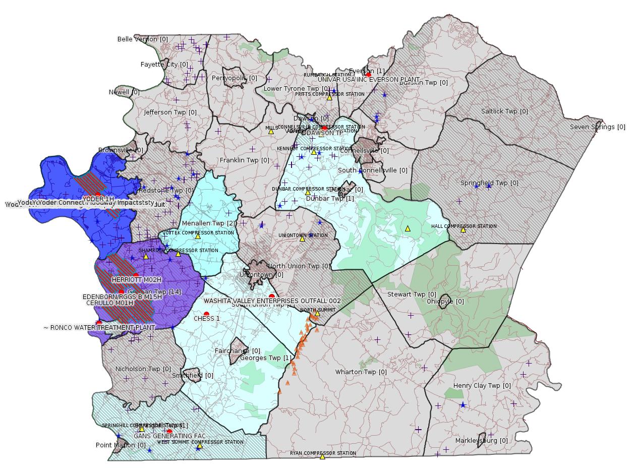
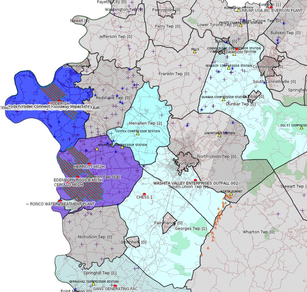
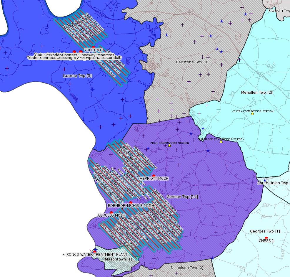
Map
Key
Red dots: items in this permit list with an exact location.
Blue stars: Marcellus Gas Well Water Sources.
Where well laterals are mapped they show in red; a 400-foot buffer surrounding the lateral shows in blue (lavender where it overlaps a mapped mineral tract).
Where mineral tracts are mapped, they show in pink. Mineral tracts can overlap; the overlap will show in red. The precise meaning of "mineral tract" is not clear.
Municipality shading: number of "facilities", with each well counting separately
(includes the red dots):
gray: 0
pale turquoise: 1
turquoise: 2
pale blue: 3
middle blue: 4
dark blue: 5
dark purple: 14
purple: 19
(Color coding may differ from one issue to the next.)
(Note if a project spans multiple municipalities -- e.g. a pipeline -- it will show in the count for each municipality.)
The number of facilities also follows the municipality name in brackets.
Municipality counts are based on the way the permit is listed by DEP; DEP has been known to get a municipality wrong.
Locations in brackets identify a precise location used to locate a surrogate for the actual site being permitted (e.g. locating a well pad or pipeline by the known location of a well.) Locations labeled beginning with "~" and ending in "[?]" are approximate and speculative based on inferences using on-line property and lease records. These are marked in the text as "[Approximate, Speculative]
Cross-hatching: Environmental Justice Areas
Yellow triangles: Compressor Stations
Orange triangles: Storage Field Wells (currently Dominion North Summit Storage Field)
Crosses: SPUD Unconventional well permits
Green: "Natural areas", e.g. state game lands, state forests
Yellow triangles: Compressor Stations
Orange triangles: Storage Field Wells (currently Dominion North Summit Storage Field)
Crosses: SPUD Unconventional well permits
Green: "Natural areas", e.g. state game lands, state forests
More Maps
 |
 |
Source: Pennsylvania Bulletin
NOTICES
DEPARTMENT OF
ENVIRONMENTAL PROTECTION
Availability of the Non-Regulatory Agenda
[49 Pa.B. 3538]
[Saturday, July 6, 2019]
In accordance with the Department of Environmental Protection's (Department) Policy for Development and Publication of Technical Guidance, the Department provides notice of the availability of the Non-Regulatory Agenda (Agenda) twice a year in February and July.
The Agenda serves as a guide and resource to the regulated community, the public, Department staff and members of the Department's advisory committees regarding the focus of the Department's policy development for the coming year. The types of documents listed in the Agenda include policies and technical guidance documents that provide directives, guidance or other relevant compliance-related information.
The Agenda is available on the Department's eLibrary web site at http://www.depgreenport.state.pa.us/elibrary/GetFolder?FolderID=4198 (select ''DEP Non-Regulatory Agenda'').
Questions regarding the Agenda should be directed to Abbey Cadden, Department of Environmental Protection, Policy Office, 400 Market Street, Harrisburg, PA 17101 at ra-epthepolicyoffice@pa.gov or (717) 783-8727.
Questions regarding a specific document should be directed to the respective contact person listed on the Agenda for that document.
PATRICK McDONNELL,
Secretary
<https://www.pabulletin.com/secure/data/vol49/49-27/1022.html>
For the actual document see:
<http://www.depgreenport.state.pa.us/elibrary/GetDocument?docId=1466113&DocName=DEP%20NON-REGULATORY%20AGENDA.PDF%20%20%20%3Cspan%20style%3D%22color%3Ablue%3B%22%3E%3C%2Fspan%3E>
---
| Facility Location Municipality & County |
Permit No. | Applicant Name & Address | Receiving Water/Use |
Contact Office & Phone No. |
|---|---|---|---|---|
| South Union Township Fayette County |
PAG036239 | Washita Valley Enterprises, Inc. P.O. Box 94160 Oklahoma City, OK 73143 |
Bennington Spring Run (WWF)—19-C |
DEP Southwest Regional Office Clean Water Program 400 Waterfront Drive Pittsburgh, PA 15222-4745 412.442.4000 |
Sub-Facilities for Authorization:
Sub-Facility ID Sub-Facility Name Description
1275056 OUTFALL 001 Discharge Point
Location: 39.875758,-79.7094
Map URL: <http://www.openstreetmap.org/?mlat=39.875758&mlon=-79.7094#map=15/39.875758/-79.7094>
1275057 OUTFALL 002 Discharge Point
Location: 39.876061,-79.70925
Map URL: <http://www.openstreetmap.org/?mlat=39.876061&mlon=-79.70925#map=15/39.876061/-79.70925>
---
TVOP-26-00495 Gans Energy, LLC (198 Butler Street, Springdale, PA 15144) In accordance with 25 Pa. Code § 127.431, the Department of Environmental Protection (DEP) is providing notice that on June 19, 2019, DEP issued a renewed Title V Operating Permit to Dominion Energy Transmission, Inc. for the continued operation of an electrical power plant, known as the Gans Power Station, located in Springhill Township, Fayette County. The proposed renewed TVOP also incorporates the applicable requirement of a Significant Permit Modification to include the 25 Pa. Code § 121.7 in the permit.
The station is a simple cycle, pipeline natural gas-fired, combustion gas turbine (CGT) power station. The main sources at this facility are two, NG-fired, 355 MMBtu/hr, heat input, turbine engines powering 44 MW electrical output, electrical generators and a cooling tower.
Annual potential emissions from the Gans Power Station are 136.6 tons of CO, 99.9 tons of NOx, 12.3 tons of VOC, 10.0 tons of PM10, 10.0 tons of PM2.5, and 6.1 tons of SO2. Gans also has potential annual emissions of 0.8 ton of formaldehyde and 1.2 ton of the sum of all HAPs combined, and 124,098 tons of CO2e. No emission or equipment changes have been approved by this action. Emission sources at the station have applicable requirements under 40 CFR Part 60, GG—Standards of Performance for Stationary Gas Turbines, Parts 72—77—Acid Rain Program requirements, and Part 97, Subparts AAAAA, BBBBB, and CCCCC—CSAPR NOx and SO2 Trading Programs and 25 Pa. Code Chapters 121—145. The emission restriction, testing, monitoring, recordkeeping, reporting and work practice conditions of the TVOP have been derived from the applicable requirements of 40 CFR Parts 52, 60, 70, 98 and 25 Pa. Code Article III, Chapters 121—145.
<https://www.pabulletin.com/secure/data/vol49/49-27/1020b.html>
-------------------------
Source: eNOTICE
(+ PA
Oil and Gas Mapping, Well
Pad Report.) Well Details via Data
Portal Services: Oil and Gas Wells All (ID: 3).
Please see the Disclaimer below regarding Parcel Id data.
Authorization ID: 1279814
Permit number: 051-24665
Site: CHESS 1H ESCGP-EXPEDITED
Client: INR OPR LLC
Authorization type: Drill & Operate Well Permit (Conventional)
Application type: Renewal
Authorization is for: FACILITY
Date received: 07/10/2019
Status: Pending
Permit Decision Guarantee Applies?: No
Sub-Facilities for Authorization:
Sub-Facility ID Sub-Facility Name Description
1261677 WELLBORE SURFACE HOLE LOCATION Well
<https://www.ahs.dep.pa.gov/eFACTSWeb/searchResults_singleAuth.aspx?AuthID=1279814>
Site Programs:
Oil & Gas
Site Municipalities:
Georges Twp, Fayette County
Well Details:
Permit Number: 051-24665
Well Name: CHESS 1
Unconventional Well: N
Well Configuration: Vertical Well
Well Type: GAS
Well Status: Active
Coal Association: Coal
Conservation Well: Y
Primary Facility ID: 827530
Site ID: 735899
Site Name: CHESS 1H ESCGP-EXPEDITED
Well Pad ID: 154471
Well Pad Name: CHESS 1
Storage Field:
Operator: INR OPR LLC
Operator Number: OGO-51036
Permit Date: 2018-08-02
Permit Date Expires: 2019-08-02
SPUD Date:
Date Plugged:
UIC ID:
UIC Type:
Surface Elevation: 1183
County: Fayette
Municipality: Georges Twp
Location: 39.859844,-79.7907
Map URL: <http://www.openstreetmap.org/?mlat=39.859844&mlon=-79.7907#map=15/39.859844/-79.7907>
OG WELLS PERMIT DOCS:
2018-08-03: Other Permit Documents, Name: RE Notification of unlocked authorization request - Authorization ID 1234983 (for Authorization: 1234983):
<http://www.depgis.state.pa.us/pdfHandler/pdFHandler.ashx?Doc=NjQyMjA5&ext=PDF>
2018-08-03: Final Permit Documents, Name: 1234983 (for Authorization: 1234983):
<http://www.depgis.state.pa.us/pdfHandler/pdFHandler.ashx?Doc=NjQ2NzMy&ext=PDF>
2019-07-11: Initial Submitted Documents, Name: 1279814 (for Authorization: 1279814):
<http://www.depgis.state.pa.us/pdfHandler/pdFHandler.ashx?Doc=ODY4NjQ1&ext=PDF>
Electronically Submitted Records:
2018-08-03: Submission for Authorization 1234983
Pennsylvania Natural Diversity Inventory Form: project_receipt_chess_1_well_658428_FINAL_1.pdf
<http://www.depgis.state.pa.us/eWellDocHandler/pdFHandler.ashx?Doc=NTc5MzQ2&ext=PDF>
Location Plat: CHESS 1_3702.dwg
<http://www.depgis.state.pa.us/eWellDocHandler/pdFHandler.ashx?Doc=NjEwNzU2&ext=PDF>
Permit Application to Drill and Operate a Well: 1764208.pdf
<http://www.depgis.state.pa.us/eWellDocHandler/pdFHandler.ashx?Doc=NjEwNzU5&ext=PDF>
Permit number: GP052607119-011
Site: Yoder Well Connect Pipeline Project
Client: LAUREL MTN MIDSTREAM OPR LLC
Authorization type: GP-05 Utility Line Stream Crossings
Application type: New
Authorization is for: FACILITY
Date received: 06/27/2019
Status: Pending
Permit Decision Guarantee Applies?: Yes
Permit Decision Guarantee status: ACTIVE
Sub-Facilities for Authorization:
Sub-Facility ID Sub-Facility Name Description
1289612 Crossing 1 Pipeline or Conduit
Location: 39.9714,-79.9387
Map URL: <http://www.openstreetmap.org/?mlat=39.9714&mlon=-79.9387#map=15/39.9714/-79.9387>
1289611 Crossing 11 PEM Pipeline or Conduit
Location: 39.9714,-79.9387
Map URL: <http://www.openstreetmap.org/?mlat=39.9714&mlon=-79.9387#map=15/39.9714/-79.9387>
1289610 Crossing 11 PSS Pipeline or Conduit
Location: 39.9714,-79.9387
Map URL: <http://www.openstreetmap.org/?mlat=39.9714&mlon=-79.9387#map=15/39.9714/-79.9387>
1289605 Crossing 2 Pipeline or Conduit
Location: 39.9714,-79.9387
Map URL: <http://www.openstreetmap.org/?mlat=39.9714&mlon=-79.9387#map=15/39.9714/-79.9387>
1289619 Crossing 2 Floodway Activity
Location: 39.9731,-79.9388
Map URL: <http://www.openstreetmap.org/?mlat=39.9731&mlon=-79.9388#map=15/39.9731/-79.9388>
1289615 Crossing 3 Floodway Activity
Location: 39.9731,-79.9388
Map URL: <http://www.openstreetmap.org/?mlat=39.9731&mlon=-79.9388#map=15/39.9731/-79.9388>
1289609 Crossing 3 Pipeline or Conduit
Location: 39.9714,-79.9387
Map URL: <http://www.openstreetmap.org/?mlat=39.9714&mlon=-79.9387#map=15/39.9714/-79.9387>
1289604 Crossing 4 Pipeline or Conduit
Location: 39.9714,-79.9387
Map URL: <http://www.openstreetmap.org/?mlat=39.9714&mlon=-79.9387#map=15/39.9714/-79.9387>
1289618 Crossing 4 Floodway Activity
Location: 39.9731,-79.9388
Map URL: <http://www.openstreetmap.org/?mlat=39.9731&mlon=-79.9388#map=15/39.9731/-79.9388>
1289606 Crossing 5 Pipeline or Conduit
Location: 39.9714,-79.9387
Map URL: <http://www.openstreetmap.org/?mlat=39.9714&mlon=-79.9387#map=15/39.9714/-79.9387>
1289616 Crossing 5 Floodway Activity
Location: 39.9731,-79.9388
Map URL: <http://www.openstreetmap.org/?mlat=39.9731&mlon=-79.9388#map=15/39.9731/-79.9388>
1289614 Crossing 6 PEM Pipeline or Conduit
Location: 39.9714,-79.9387
Map URL: <http://www.openstreetmap.org/?mlat=39.9714&mlon=-79.9387#map=15/39.9714/-79.9387>
1289613 Crossing 6 PFO Pipeline or Conduit
Location: 39.9714,-79.9387
Map URL: <http://www.openstreetmap.org/?mlat=39.9714&mlon=-79.9387#map=15/39.9714/-79.9387>
1289617 Crossing 8 Floodway Activity
Location: 39.9731,-79.9388
Map URL: <http://www.openstreetmap.org/?mlat=39.9731&mlon=-79.9388#map=15/39.9731/-79.9388>
1289608 Crossing 8 Pipeline or Conduit
Location: 39.9714,-79.9387
Map URL: <http://www.openstreetmap.org/?mlat=39.9714&mlon=-79.9387#map=15/39.9714/-79.9387>
1289607 Crossing 9 Pipeline or Conduit
Location: 39.9714,-79.9387
Map URL: <http://www.openstreetmap.org/?mlat=39.9714&mlon=-79.9387#map=15/39.9714/-79.9387>
1289624 Floodway Impacts Summed Floodway Direct Impact
Location: 39.973,-79.9339
Map URL: <http://www.openstreetmap.org/?mlat=39.973&mlon=-79.9339#map=15/39.973/-79.9339>
1289622 PEM Wetland Impacts Summed Wetland Direct Impact
Location: 39.973,-79.9339
Map URL: <http://www.openstreetmap.org/?mlat=39.973&mlon=-79.9339#map=15/39.973/-79.9339>
1289621 PFO Wetland Impacts Summed Wetland Direct Impact
Location: 39.973,-79.9339
Map URL: <http://www.openstreetmap.org/?mlat=39.973&mlon=-79.9339#map=15/39.973/-79.9339>
1289620 PSS Wetland Impacts Summed Wetland Direct Impact
Location: 39.973,-79.9339
Map URL: <http://www.openstreetmap.org/?mlat=39.973&mlon=-79.9339#map=15/39.973/-79.9339>
1289623 Stream Impacts Summed Stream Direct Impact
Location: 39.973,-79.9339
Map URL: <http://www.openstreetmap.org/?mlat=39.973&mlon=-79.9339#map=15/39.973/-79.9339>
Permit Review Notes:
Date Review Note
7/2/2019 The permit application package is complete, has been accepted, and is undergoing technical review.
<https://www.ahs.dep.pa.gov/eFACTSWeb/searchResults_singleAuth.aspx?AuthID=1278429>
Site Programs:
Water Planning and Conservation
Site Municipalities:
Luzerne Twp, Fayette County
---
Authorization ID: 1278428
Permit number: GP082607119-008
Site: Yoder Well Connect Pipeline Project
Client: LAUREL MTN MIDSTREAM OPR LLC
Authorization type: GP-08 Temporary Road Crossings
Application type: New
Authorization is for: FACILITY
Date received: 06/27/2019
Status: Pending
Permit Decision Guarantee Applies?: No
Sub-Facilities for Authorization:
Sub-Facility ID Sub-Facility Name Description
1289598 Crossing 1 Mat/Pads
Location: 39.9712,-79.9382
Map URL: <http://www.openstreetmap.org/?mlat=39.9712&mlon=-79.9382#map=15/39.9712/-79.9382>
1289602 Crossing 10 Mat/Pads
Location: 39.9712,-79.9382
Map URL: <http://www.openstreetmap.org/?mlat=39.9712&mlon=-79.9382#map=15/39.9712/-79.9382>
1289601 Crossing 11 Mat/Pads
Location: 39.9712,-79.9382
Map URL: <http://www.openstreetmap.org/?mlat=39.9712&mlon=-79.9382#map=15/39.9712/-79.9382>
1289596 Crossing 2 Bridge
Location: 39.9731,-79.9336
Map URL: <http://www.openstreetmap.org/?mlat=39.9731&mlon=-79.9336#map=15/39.9731/-79.9336>
1289592 Crossing 3 Bridge
Location: 39.9731,-79.9336
Map URL: <http://www.openstreetmap.org/?mlat=39.9731&mlon=-79.9336#map=15/39.9731/-79.9336>
1289593 Crossing 4 Bridge
Location: 39.9731,-79.9336
Map URL: <http://www.openstreetmap.org/?mlat=39.9731&mlon=-79.9336#map=15/39.9731/-79.9336>
1289594 Crossing 5 Bridge
Location: 39.9731,-79.9336
Map URL: <http://www.openstreetmap.org/?mlat=39.9731&mlon=-79.9336#map=15/39.9731/-79.9336>
1289599 Crossing 7 Mat/Pads
Location: 39.9712,-79.9382
Map URL: <http://www.openstreetmap.org/?mlat=39.9712&mlon=-79.9382#map=15/39.9712/-79.9382>
1289595 Crossing 8 Bridge
Location: 39.9731,-79.9336
Map URL: <http://www.openstreetmap.org/?mlat=39.9731&mlon=-79.9336#map=15/39.9731/-79.9336>
1289600 Crossing 9 Mat/Pads
Location: 39.9712,-79.9382
Map URL: <http://www.openstreetmap.org/?mlat=39.9712&mlon=-79.9382#map=15/39.9712/-79.9382>
1289603 Floodway Impacts Summed Temporary Floodway Impact
Location: 39.973,-79.9339
Map URL: <http://www.openstreetmap.org/?mlat=39.973&mlon=-79.9339#map=15/39.973/-79.9339>
1289597 Wetland Impacts Summed Temporary Wetland Impact
Location: 39.973,-79.9339
Map URL: <http://www.openstreetmap.org/?mlat=39.973&mlon=-79.9339#map=15/39.973/-79.9339>
Permit Review Notes:
Date Review Note
7/2/2019 The permit application package is complete, has been accepted, and is undergoing technical review.
<https://www.ahs.dep.pa.gov/eFACTSWeb/searchResults_singleAuth.aspx?AuthID=1278428>
Site Programs:
Water Planning and Conservation
Site Municipalities:
Luzerne Twp, Fayette County
---
Authorization ID: 1274536
Permit number: GP112607219-014
Site: S PA GATHERING SYSTEM ABANDONMENT PPL 7663 & 7666 PROJ GP08 GP11
Client: COLUMBIA GAS TRANS
Authorization type: BWM-GP-11 Maintenance, Testing, Repair, Rehabilitation or Replacement General Pmt
Application type: New
Authorization is for: FACILITY
Date received: 05/21/2019
Status: Pending
Permit Decision Guarantee Applies?: Yes
Permit Decision Guarantee status: ACTIVE
Sub-Facilities for Authorization:
Sub-Facility ID Sub-Facility Name Description
1287626 S PA GATHERING SYS ABANDONMENT PPL 7663 AND 7666 PROJ Other Activities
Permit Review Notes:
Date Review Note
5/30/2019 The permit application package is complete, has been accepted, and is undergoing technical review.
<https://www.ahs.dep.pa.gov/eFACTSWeb/searchResults_singleAuth.aspx?AuthID=1274536>
Site Programs:
Water Planning and Conservation
Site Municipalities:
Luzerne Twp, Fayette County
---
Authorization ID: 1274535
Permit number: GP082607219-006
Site: S PA GATHERING SYSTEM ABANDONMENT PPL 7663 & 7666 PROJ GP08 GP11
Client: COLUMBIA GAS TRANS
Authorization type: GP-08 Temporary Road Crossings
Application type: New
Authorization is for: FACILITY
Date received: 05/21/2019
Status: Pending
Permit Decision Guarantee Applies?: No
Sub-Facilities for Authorization:
Sub-Facility ID Sub-Facility Name Description
1287625 S PA GATHERING SYS ABANDONMENT PPL 7663 AND 7666 PROJ Bridge
Permit Review Notes:
Date Review Note
5/30/2019 The permit application package is complete, has been accepted, and is undergoing technical review.
<https://www.ahs.dep.pa.gov/eFACTSWeb/searchResults_singleAuth.aspx?AuthID=1274535>
Site Programs:
Water Planning and Conservation
Site Municipalities:
Luzerne Twp, Fayette County
---
Authorization ID: 1274532
Permit number: GP112607219-013
Site: SOUTHERN PA GATHERING SYSTEM ABANDONMENT PIPELINE 8610 PROJECT GP08 GP11
Client: COLUMBIA GAS TRANS
Authorization type: BWM-GP-11 Maintenance, Testing, Repair, Rehabilitation or Replacement General Pmt
Application type: New
Authorization is for: FACILITY
Date received: 05/23/2019
Status: Pending
Permit Decision Guarantee Applies?: Yes
Permit Decision Guarantee status: ACTIVE
Sub-Facilities for Authorization:
Sub-Facility ID Sub-Facility Name Description
1287623 S PA GATHERING SYS ABANDONMENT PPL 8610 PROJECT GP11 Other Activities
Permit Review Notes:
Date Review Note
5/30/2019 The permit application package is complete, has been accepted, and is undergoing technical review.
<https://www.ahs.dep.pa.gov/eFACTSWeb/searchResults_singleAuth.aspx?AuthID=1274532>
Site Programs:
Water Planning and Conservation
Site Municipalities:
German Twp [an Environmental Justice Area], Fayette County
---
Authorization ID: 1274531
Permit number: GP082607219-005
Site: SOUTHERN PA GATHERING SYSTEM ABANDONMENT PIPELINE 8610 PROJECT GP08 GP11
Client: COLUMBIA GAS TRANS
Authorization type: GP-08 Temporary Road Crossings
Application type: New
Authorization is for: FACILITY
Date received: 05/23/2019
Status: Pending
Permit Decision Guarantee Applies?: No
Sub-Facilities for Authorization:
Sub-Facility ID Sub-Facility Name Description
1287622 S PA GATHERING SYS ABANDONMENT PPL 8610 PROJECT GP08 Bridge
Permit Review Notes:
Date Review Note
5/30/2019 The permit application package is complete, has been accepted, and is undergoing technical review.
<https://www.ahs.dep.pa.gov/eFACTSWeb/searchResults_singleAuth.aspx?AuthID=1274531>
Site Programs:
Water Planning and Conservation
Site Municipalities:
German Twp [an Environmental Justice Area], Fayette County
---
Authorization ID: 1274525
Permit number: GP112607219-012
Site: SOUTHERN PA GATHERING SYSTEM ABANDONMENT PIPELINE 7645 PROJECT GP08 GP11
Client: COLUMBIA GAS TRANS
Authorization type: BWM-GP-11 Maintenance, Testing, Repair, Rehabilitation or Replacement General Pmt
Application type: New
Authorization is for: FACILITY
Date received: 05/23/2019
Status: Pending
Permit Decision Guarantee Applies?: Yes
Permit Decision Guarantee status: VOID
Sub-Facilities for Authorization:
Sub-Facility ID Sub-Facility Name Description
1287617 S PA GATHERING SYS ABANDONMENT PPL 7645 PROJ GP11 Other Activities
Permit Review Notes:
Date Review Note
7/9/2019 Applicant has been issued a deficiency letter. If applicable, this application no longer qualifies for the Permit Decision Guarantee.
5/30/2019 The permit application package is complete, has been accepted, and is undergoing technical review.
<https://www.ahs.dep.pa.gov/eFACTSWeb/searchResults_singleAuth.aspx?AuthID=1274525>
Site Programs:
Water Planning and Conservation
Site Municipalities:
Menallen Twp, Fayette County
---
Authorization ID: 1274524
Permit number: GP082607219-004
Site: SOUTHERN PA GATHERING SYSTEM ABANDONMENT PIPELINE 7645 PROJECT GP08 GP11
Client: COLUMBIA GAS TRANS
Authorization type: GP-08 Temporary Road Crossings
Application type: New
Authorization is for: FACILITY
Date received: 05/23/2019
Status: Pending
Permit Decision Guarantee Applies?: No
Sub-Facilities for Authorization:
Sub-Facility ID Sub-Facility Name Description
1287616 S PA GATHERING SYS ABANDONMENT PPL 7645 PROJ GP08 Bridge
Permit Review Notes:
Date Review Note
7/9/2019 Applicant has been issued a deficiency letter. If applicable, this application no longer qualifies for the Permit Decision Guarantee.
5/30/2019 The permit application package is complete, has been accepted, and is undergoing technical review.
<https://www.ahs.dep.pa.gov/eFACTSWeb/searchResults_singleAuth.aspx?AuthID=1274524>
Site Programs:
Water Planning and Conservation
Site Municipalities:
Menallen Twp, Fayette County
---
Authorization ID: 1273834
Permit number: GP112607219-002
Site: SOUTHERN PA GATHERING SYSTEM ABANDONMENT PPL 7894 PROJECTGP 08
Client: COLUMBIA GAS TRANS
Authorization type: BWM-GP-11 Maintenance, Testing, Repair, Rehabilitation or Replacement General Pmt
Application type: New
Authorization is for: FACILITY
Date received: 04/29/2019
Status: Issued on 7/3/2019
Permit Decision Guarantee Applies?: Yes
Permit Decision Guarantee status: ACTIVE
Permit Review Notes:
Date Review Note
7/3/2019 The technical review and decision review are complete and either the permit decision and/or permit issuance are forthcoming.
5/20/2019 The permit application package is complete, has been accepted, and is undergoing technical review.
<https://www.ahs.dep.pa.gov/eFACTSWeb/searchResults_singleAuth.aspx?AuthID=1273834>
Site Programs:
Water Planning and Conservation
Site Municipalities:
Menallen Twp, Fayette County
---
Authorization ID: 1271846
Permit number: PA0217778
Site: DAWSON TP
Client: KEYROCK ENERGY LLC
Authorization type: Minor IW Facility without ELG
Application type: Renewal
Authorization is for: FACILITY
Date received: 11/28/2017
Status: Pending
Permit Decision Guarantee Applies?: No
Sub-Facilities for Authorization:
Sub-Facility ID Sub-Facility Name Description
1025459 OUTFALL 001 Discharge Point
Location: 40.036247,-79.640533
Map URL: <http://www.openstreetmap.org/?mlat=40.036247&mlon=-79.640533#map=15/40.036247/-79.640533>
Permit Review Notes:
Date Review Note
7/8/2019 The technical review and decision review are complete and either the permit decision and/or permit issuance are forthcoming.
4/26/2019 The permit application package is complete, has been accepted, and is undergoing technical review.
<https://www.ahs.dep.pa.gov/eFACTSWeb/searchResults_singleAuth.aspx?AuthID=1271846>
Site Programs:
Clean Water
Oil & Gas
Site Municipalities:
Dunbar Twp, Fayette County
---
Authorization ID: 1263830
Permit number: GP042607219-001
Site: RONCO WATER TREATMENT PLANT GP02 GP04
Client: APPALACHIAN WATER SVC LLC
Authorization type: GP-04 Intake & Outfall Structures
Application type: New
Authorization is for: FACILITY
Date received: 02/27/2019
Status: Issued on 7/2/2019
Permit Decision Guarantee Applies?: No
Sub-Facilities for Authorization:
Sub-Facility ID Sub-Facility Name Description
1289769 RONCO WATER TREATMENT PLANT GP02 Intake Structure
Location: 39.8533,-79.9252
Map URL: <http://www.openstreetmap.org/?mlat=39.8533&mlon=-79.9252#map=15/39.8533/-79.9252>
1282358 RONCO WATER TREATMENT PLANT GP04 Intake Structure
Permit Review Notes:
Date Review Note
7/1/2019 The technical review and decision review are complete and either the permit decision and/or permit issuance are forthcoming.
3/13/2019 The permit application package is complete, has been accepted, and is undergoing technical review.
3/13/2019 DEP's interim review is complete. Final decision review/permit issuance is pending receipt of comments/approvals from other state or federal resources agencies.
<https://www.ahs.dep.pa.gov/eFACTSWeb/searchResults_singleAuth.aspx?AuthID=1263830>
Site Programs:
Water Planning and Conservation
Site Municipalities:
Masontown Boro, Fayette County
---
Authorization ID: 1263829
Permit number: GP022607219-001
Site: RONCO WATER TREATMENT PLANT GP02 GP04
Client: APPALACHIAN WATER SVC LLC
Authorization type: GP-02 Small Docks & Boat Launch Ramps
Application type: New
Authorization is for: FACILITY
Date received: 02/27/2019
Status: Issued on 7/2/2019
Permit Decision Guarantee Applies?: No
Sub-Facilities for Authorization:
Sub-Facility ID Sub-Facility Name Description
1282357 RONCO WATER TREATMENT PLANT GP02 Dock
Location: 39.8533,-79.9252
Map URL: <http://www.openstreetmap.org/?mlat=39.8533&mlon=-79.9252#map=15/39.8533/-79.9252>
Permit Review Notes:
Date Review Note
7/1/2019 The technical review and decision review are complete and either the permit decision and/or permit issuance are forthcoming.
3/13/2019 The permit application package is complete, has been accepted, and is undergoing technical review.
3/13/2019 DEP's interim review is complete. Final decision review/permit issuance is pending receipt of comments/approvals from other state or federal resources agencies.
<https://www.ahs.dep.pa.gov/eFACTSWeb/searchResults_singleAuth.aspx?AuthID=1263829>
Site Programs:
Water Planning and Conservation
Site Municipalities:
Masontown Boro, Fayette County
---
Authorization ID: 1255021
Permit number: GP082607218505
Site: SOUTHERN PA GATHERING SYSTEM ABANDONMENT PPL 7894 PROJECTGP 08
Client: COLUMBIA GAS TRANS
Authorization type: GP-08 Temporary Road Crossings
Application type: New
Authorization is for: FACILITY
Date received: 12/11/2018
Status: Issued on 7/3/2019
Permit Decision Guarantee Applies?: No
Sub-Facilities for Authorization:
Sub-Facility ID Sub-Facility Name Description
1276753 S PA GATHERING SYSTEM ABANDONMENT PPL 7894 PROJECT GP08 Bridge
Permit Review Notes:
Date Review Note
7/3/2019 The technical review and decision review are complete and either the permit decision and/or permit issuance are forthcoming.
4/29/2019 Applicant has been issued a deficiency letter. If applicable, this application no longer qualifies for the Permit Decision Guarantee.
<https://www.ahs.dep.pa.gov/eFACTSWeb/searchResults_singleAuth.aspx?AuthID=1255021>
Site Programs:
Water Planning and Conservation
Site Municipalities:
Menallen Twp, Fayette County
---
Authorization ID: 1061896
Permit number: 26-00595
Site: UNIVAR USA INC EVERSON PLANT
Client: UNIVAR USA INC
Authorization type: Minor Source Operating Permit
Application type: New
Authorization is for: FACILITY
Date received: 02/18/2015
Status: Pending
Permit Decision Guarantee Applies?: No
Sub-Facilities for Authorization:
Sub-Facility ID Sub-Facility Name Description
1289953 FERTILIZER PRODUCTION BAGHOUSE (2,000 SCFM) Air Pollution Control Device
Location: 40.08681,-79.58443
Map URL: <http://www.openstreetmap.org/?mlat=40.08681&mlon=-79.58443#map=15/40.08681/-79.58443>
1289954 FERTILIZER PRODUCTION MULTICYCLONE Air Pollution Control Device
Location: 40.08681,-79.58443
Map URL: <http://www.openstreetmap.org/?mlat=40.08681&mlon=-79.58443#map=15/40.08681/-79.58443>
1289952 FERTILIZER PRODUCTION/MIXING PROCESS Process
Location: 40.08681,-79.58443
Map URL: <http://www.openstreetmap.org/?mlat=40.08681&mlon=-79.58443#map=15/40.08681/-79.58443>
1289955 GUAR PRODUCTION Process
Location: 40.08681,-79.58443
Map URL: <http://www.openstreetmap.org/?mlat=40.08681&mlon=-79.58443#map=15/40.08681/-79.58443>
1289957 GUAR PRODUCTION BAGHOUSE Air Pollution Control Device
Location: 40.08681,-79.58443
Map URL: <http://www.openstreetmap.org/?mlat=40.08681&mlon=-79.58443#map=15/40.08681/-79.58443>
1289964 HYDROCHLORIC ACID (HCL) TRANSLOADING Process
Location: 40.08681,-79.58443
Map URL: <http://www.openstreetmap.org/?mlat=40.08681&mlon=-79.58443#map=15/40.08681/-79.58443>
1289962 KOHLER 75-HP EMERGENCY GENERATOR Process
Location: 40.08681,-79.58443
Map URL: <http://www.openstreetmap.org/?mlat=40.08681&mlon=-79.58443#map=15/40.08681/-79.58443>
1289960 LIQUID BAY Process
Location: 40.08681,-79.58443
Map URL: <http://www.openstreetmap.org/?mlat=40.08681&mlon=-79.58443#map=15/40.08681/-79.58443>
1064910 NATURAL GAS-FIRED BOILER 9.975 MMBTU/HR Combustion Unit
1289967 VAPOR RECOVERY UNIT Air Pollution Control Device
Location: 40.08681,-79.58443
Map URL: <http://www.openstreetmap.org/?mlat=40.08681&mlon=-79.58443#map=15/40.08681/-79.58443>
1289965 WET SCRUBBER Air Pollution Control Device
Location: 40.08681,-79.58443
Map URL: <http://www.openstreetmap.org/?mlat=40.08681&mlon=-79.58443#map=15/40.08681/-79.58443>
Permit Review Notes:
Date Review Note
4/15/2019 The permit application package is complete, has been accepted, and is undergoing technical review.
<https://www.ahs.dep.pa.gov/eFACTSWeb/searchResults_singleAuth.aspx?AuthID=1061896>
Site Programs:
Air Quality
Clean Water
Waste Management
Water Planning and Conservation
Site Municipalities:
Bullskin Twp, Fayette County
-------------------------
Well Details:
Permit Number: 051-24693
Well Name: CERULLO M01H
Unconventional Well: Y
Well Configuration: Horizontal Well
Well Type: GAS
Well Status: Active
Coal Association: Coal
Conservation Well: N
Primary Facility ID: 830835
Site ID: 829618
Site Name: CERULLO PAD A ESCGP ESX18-051-0004
Well Pad ID: 155068
Well Pad Name: CERULLO
Storage Field:
Operator: CHEVRON APPALACHIA LLC
Operator Number: OGO-39307
Permit Date: 2019-01-11
Permit Date Expires: 2020-01-11
SPUD Date: 2019-07-04
Date Plugged:
UIC ID:
UIC Type:
Surface Elevation: 1063
County: Fayette
Municipality: German Twp [an Environmental Justice Area]
Location: 39.876242,-79.911319
Map URL: <http://www.openstreetmap.org/?mlat=39.876242&mlon=-79.911319#map=15/39.876242/-79.911319>
OG WELLS PERMIT DOCS:
2019-01-11: Other Permit Documents, Name: CerulloPad_Notification_of_unlocked_authorization_request-AuthorizationID1253994 (for Authorization: 1253994):
<http://www.depgis.state.pa.us/pdfHandler/pdFHandler.ashx?Doc=NzI2MjA3&ext=PDF>
2019-01-11: Final Permit Documents, Name: 051-24693 (for Authorization: 1253994):
<http://www.depgis.state.pa.us/pdfHandler/pdFHandler.ashx?Doc=NzMwNTQ3&ext=PDF>
2019-04-17: Other Permit Documents, Name: Alternate Method (for Authorization: 1263965):
<http://www.depgis.state.pa.us/pdfHandler/pdFHandler.ashx?Doc=NzkwNDAy&ext=PDF>
Electronically Submitted Records:
2019-01-11: Submission for Authorization 1253994
Pennsylvania Natural Diversity Inventory Form: Cerullo PNDI.pdf
<http://www.depgis.state.pa.us/eWellDocHandler/pdFHandler.ashx?Doc=NzAzNDEz&ext=PDF>
Well Cross-Section Diagram: Cerullo M01H Page 4.pdf
<http://www.depgis.state.pa.us/eWellDocHandler/pdFHandler.ashx?Doc=NzAzNDE1&ext=PDF>
Location Plat: CERULLO Well Plat M01H.dwg
<http://www.depgis.state.pa.us/eWellDocHandler/pdFHandler.ashx?Doc=NzI4MjI2&ext=PDF>
Permit Application to Drill and Operate a Well: 1842469.pdf
<http://www.depgis.state.pa.us/eWellDocHandler/pdFHandler.ashx?Doc=NzI4NTQ5&ext=PDF>
Presumed Parcel Id: 15190070
---
Well Details:
Permit Number: 051-24695
Well Name: CERULLO M02H
Unconventional Well: Y
Well Configuration: Horizontal Well
Well Type: GAS
Well Status: Active
Coal Association: Coal
Conservation Well: N
Primary Facility ID: 830837
Site ID: 829618
Site Name: CERULLO PAD A ESCGP ESX18-051-0004
Well Pad ID: 155068
Well Pad Name: CERULLO
Storage Field:
Operator: CHEVRON APPALACHIA LLC
Operator Number: OGO-39307
Permit Date: 2019-01-11
Permit Date Expires: 2020-01-11
SPUD Date: 2019-07-04
Date Plugged:
UIC ID:
UIC Type:
Surface Elevation: 1063
County: Fayette
Municipality: German Twp [an Environmental Justice Area]
Location: 39.876275,-79.91135
Map URL: <http://www.openstreetmap.org/?mlat=39.876275&mlon=-79.91135#map=15/39.876275/-79.91135>
OG WELLS PERMIT DOCS:
2019-01-11: Other Permit Documents, Name: CerulloPad_Notification_of_unlocked_authorization_request-AuthorizationID1253996 (for Authorization: 1253996):
<http://www.depgis.state.pa.us/pdfHandler/pdFHandler.ashx?Doc=NzI2MjE0&ext=PDF>
2019-01-11: Final Permit Documents, Name: 051-24695 (for Authorization: 1253996):
<http://www.depgis.state.pa.us/pdfHandler/pdFHandler.ashx?Doc=NzMwNTUw&ext=PDF>
2019-04-17: Other Permit Documents, Name: Alternate Method (for Authorization: 1263966):
<http://www.depgis.state.pa.us/pdfHandler/pdFHandler.ashx?Doc=NzkwMzkx&ext=PDF>
Electronically Submitted Records:
2019-01-11: Submission for Authorization 1253996
Pennsylvania Natural Diversity Inventory Form: Cerullo PNDI.pdf
<http://www.depgis.state.pa.us/eWellDocHandler/pdFHandler.ashx?Doc=NzAzNDIy&ext=PDF>
Well Cross-Section Diagram: Cerullo M02H Page 4.pdf
<http://www.depgis.state.pa.us/eWellDocHandler/pdFHandler.ashx?Doc=NzAzNDIz&ext=PDF>
Location Plat: CERULLO Well Plat M02H.dwg
<http://www.depgis.state.pa.us/eWellDocHandler/pdFHandler.ashx?Doc=NzI4MjI3&ext=PDF>
Permit Application to Drill and Operate a Well: 1842505.pdf
<http://www.depgis.state.pa.us/eWellDocHandler/pdFHandler.ashx?Doc=NzI4NTU3&ext=PDF>
---
Well Details:
Permit Number: 051-24692
Well Name: CERULLO M03H
Unconventional Well: Y
Well Configuration: Horizontal Well
Well Type: GAS
Well Status: Active
Coal Association: Coal
Conservation Well: N
Primary Facility ID: 830834
Site ID: 829618
Site Name: CERULLO PAD A ESCGP ESX18-051-0004
Well Pad ID: 155068
Well Pad Name: CERULLO
Storage Field:
Operator: CHEVRON APPALACHIA LLC
Operator Number: OGO-39307
Permit Date: 2019-01-11
Permit Date Expires: 2020-01-11
SPUD Date: 2019-07-05
Date Plugged:
UIC ID:
UIC Type:
Surface Elevation: 1063
County: Fayette
Municipality: German Twp [an Environmental Justice Area]
Location: 39.876308,-79.911383
Map URL: <http://www.openstreetmap.org/?mlat=39.876308&mlon=-79.911383#map=15/39.876308/-79.911383>
OG WELLS PERMIT DOCS:
2019-01-11: Other Permit Documents, Name: CerulloPad_Notification_of_unlocked_authorization_request-AuthorizationID1253993 (for Authorization: 1253993):
<http://www.depgis.state.pa.us/pdfHandler/pdFHandler.ashx?Doc=NzI2MjI0&ext=PDF>
2019-01-11: Final Permit Documents, Name: 051-24692 (for Authorization: 1253993):
<http://www.depgis.state.pa.us/pdfHandler/pdFHandler.ashx?Doc=NzMwNTU4&ext=PDF>
2019-04-17: Other Permit Documents, Name: Alternate Method (for Authorization: 1263967):
<http://www.depgis.state.pa.us/pdfHandler/pdFHandler.ashx?Doc=NzkwMzk1&ext=PDF>
Electronically Submitted Records:
2019-01-11: Submission for Authorization 1253993
Pennsylvania Natural Diversity Inventory Form: Cerullo PNDI.pdf
<http://www.depgis.state.pa.us/eWellDocHandler/pdFHandler.ashx?Doc=NzAzNDQw&ext=PDF>
Well Cross-Section Diagram: Cerullo M03H Page 4.pdf
<http://www.depgis.state.pa.us/eWellDocHandler/pdFHandler.ashx?Doc=NzAzNDQx&ext=PDF>
Location Plat: CERULLO Well Plat M03H.dwg
<http://www.depgis.state.pa.us/eWellDocHandler/pdFHandler.ashx?Doc=NzI4MjI4&ext=PDF>
Permit Application to Drill and Operate a Well: 1842522.pdf
<http://www.depgis.state.pa.us/eWellDocHandler/pdFHandler.ashx?Doc=NzI4NTYw&ext=PDF>
---
Well Details:
Permit Number: 051-24694
Well Name: CERULLO M04H
Unconventional Well: Y
Well Configuration: Horizontal Well
Well Type: GAS
Well Status: Active
Coal Association: Coal
Conservation Well: N
Primary Facility ID: 830836
Site ID: 829618
Site Name: CERULLO PAD A ESCGP ESX18-051-0004
Well Pad ID: 155068
Well Pad Name: CERULLO
Storage Field:
Operator: CHEVRON APPALACHIA LLC
Operator Number: OGO-39307
Permit Date: 2019-01-11
Permit Date Expires: 2020-01-11
SPUD Date: 2019-07-05
Date Plugged:
UIC ID:
UIC Type:
Surface Elevation: 1063
County: Fayette
Municipality: German Twp [an Environmental Justice Area]
Location: 39.876342,-79.911414
Map URL: <http://www.openstreetmap.org/?mlat=39.876342&mlon=-79.911414#map=15/39.876342/-79.911414>
OG WELLS PERMIT DOCS:
2019-01-11: Other Permit Documents, Name: CerulloPad_Notification_of_unlocked_authorization_request-AuthorizationID1253995 (for Authorization: 1253995):
<http://www.depgis.state.pa.us/pdfHandler/pdFHandler.ashx?Doc=NzI2MjQ1&ext=PDF>
2019-01-11: Final Permit Documents, Name: 051-24694 (for Authorization: 1253995):
<http://www.depgis.state.pa.us/pdfHandler/pdFHandler.ashx?Doc=NzMwNTUy&ext=PDF>
2019-04-17: Other Permit Documents, Name: Alternate Method (for Authorization: 1263968):
<http://www.depgis.state.pa.us/pdfHandler/pdFHandler.ashx?Doc=NzkwMzk0&ext=PDF>
Electronically Submitted Records:
2019-01-11: Submission for Authorization 1253995
Pennsylvania Natural Diversity Inventory Form: Cerullo PNDI.pdf
<http://www.depgis.state.pa.us/eWellDocHandler/pdFHandler.ashx?Doc=NzAzNDUw&ext=PDF>
Well Cross-Section Diagram: Cerullo M04H Page 4.pdf
<http://www.depgis.state.pa.us/eWellDocHandler/pdFHandler.ashx?Doc=NzAzNDUy&ext=PDF>
Location Plat: CERULLO Well Plat M04H.dwg
<http://www.depgis.state.pa.us/eWellDocHandler/pdFHandler.ashx?Doc=NzI4MjMy&ext=PDF>
Permit Application to Drill and Operate a Well: 1842531.pdf
<http://www.depgis.state.pa.us/eWellDocHandler/pdFHandler.ashx?Doc=NzI4NTY4&ext=PDF>
---
Well Details:
Permit Number: 051-24690
Well Name: CERULLO M09H
Unconventional Well: Y
Well Configuration: Horizontal Well
Well Type: GAS
Well Status: Active
Coal Association: Coal
Conservation Well: N
Primary Facility ID: 830832
Site ID: 829618
Site Name: CERULLO PAD A ESCGP ESX18-051-0004
Well Pad ID: 155068
Well Pad Name: CERULLO
Storage Field:
Operator: CHEVRON APPALACHIA LLC
Operator Number: OGO-39307
Permit Date: 2019-01-11
Permit Date Expires: 2020-01-11
SPUD Date: 2019-07-06
Date Plugged:
UIC ID:
UIC Type:
Surface Elevation: 1063
County: Fayette
Municipality: German Twp [an Environmental Justice Area]
Location: 39.876192,-79.911406
Map URL: <http://www.openstreetmap.org/?mlat=39.876192&mlon=-79.911406#map=15/39.876192/-79.911406>
OG WELLS PERMIT DOCS:
2019-01-11: Other Permit Documents, Name: CerulloPad_Notification_of_unlocked_authorization_request-AuthorizationID1253991 (for Authorization: 1253991):
<http://www.depgis.state.pa.us/pdfHandler/pdFHandler.ashx?Doc=NzI2MjUy&ext=PDF>
2019-01-11: Final Permit Documents, Name: 051-24690 (for Authorization: 1253991):
<http://www.depgis.state.pa.us/pdfHandler/pdFHandler.ashx?Doc=NzMwNTUz&ext=PDF>
2019-04-17: Other Permit Documents, Name: Alternate Method (for Authorization: 1263969):
<http://www.depgis.state.pa.us/pdfHandler/pdFHandler.ashx?Doc=NzkwNDA0&ext=PDF>
Electronically Submitted Records:
2019-01-11: Submission for Authorization 1253991
Pennsylvania Natural Diversity Inventory Form: Cerullo PNDI.pdf
<http://www.depgis.state.pa.us/eWellDocHandler/pdFHandler.ashx?Doc=NzAzNDU5&ext=PDF>
Well Cross-Section Diagram: Cerullo M09H Page 4.pdf
<http://www.depgis.state.pa.us/eWellDocHandler/pdFHandler.ashx?Doc=NzAzNDYx&ext=PDF>
Location Plat: CERULLO Well Plat M09H.dwg
<http://www.depgis.state.pa.us/eWellDocHandler/pdFHandler.ashx?Doc=NzI4MjM0&ext=PDF>
Permit Application to Drill and Operate a Well: 1842671.pdf
<http://www.depgis.state.pa.us/eWellDocHandler/pdFHandler.ashx?Doc=NzI4NTc0&ext=PDF>
---
Well Details:
Permit Number: 051-24691
Well Name: CERULLO M10H
Unconventional Well: Y
Well Configuration: Horizontal Well
Well Type: GAS
Well Status: Active
Coal Association: Coal
Conservation Well: N
Primary Facility ID: 830833
Site ID: 829618
Site Name: CERULLO PAD A ESCGP ESX18-051-0004
Well Pad ID: 155068
Well Pad Name: CERULLO
Storage Field:
Operator: CHEVRON APPALACHIA LLC
Operator Number: OGO-39307
Permit Date: 2019-01-11
Permit Date Expires: 2020-01-11
SPUD Date: 2019-07-06
Date Plugged:
UIC ID:
UIC Type:
Surface Elevation: 1063
County: Fayette
Municipality: German Twp [an Environmental Justice Area]
Location: 39.876225,-79.911436
Map URL: <http://www.openstreetmap.org/?mlat=39.876225&mlon=-79.911436#map=15/39.876225/-79.911436>
OG WELLS PERMIT DOCS:
2019-01-11: Other Permit Documents, Name: CerulloPad_Notification_of_unlocked_authorization_request-AuthorizationID1253992 (for Authorization: 1253992):
<http://www.depgis.state.pa.us/pdfHandler/pdFHandler.ashx?Doc=NzI2MjU1&ext=PDF>
2019-01-11: Final Permit Documents, Name: 051-24691 (for Authorization: 1253992):
<http://www.depgis.state.pa.us/pdfHandler/pdFHandler.ashx?Doc=NzMwNTYy&ext=PDF>
2019-04-17: Other Permit Documents, Name: Alternate Method (for Authorization: 1263971):
<http://www.depgis.state.pa.us/pdfHandler/pdFHandler.ashx?Doc=NzkwNDA2&ext=PDF>
Electronically Submitted Records:
2019-01-11: Submission for Authorization 1253992
Pennsylvania Natural Diversity Inventory Form: Cerullo PNDI.pdf
<http://www.depgis.state.pa.us/eWellDocHandler/pdFHandler.ashx?Doc=NzAzNDY5&ext=PDF>
Well Cross-Section Diagram: Cerullo M10H Page 4.pdf
<http://www.depgis.state.pa.us/eWellDocHandler/pdFHandler.ashx?Doc=NzAzNDcx&ext=PDF>
Location Plat: CERULLO Well Plat M10H.dwg
<http://www.depgis.state.pa.us/eWellDocHandler/pdFHandler.ashx?Doc=NzI4MjM3&ext=PDF>
Permit Application to Drill and Operate a Well: 1842680.pdf
<http://www.depgis.state.pa.us/eWellDocHandler/pdFHandler.ashx?Doc=NzI4NTc4&ext=PDF>
---
Well Details:
Permit Number: 051-24696
Well Name: CERULLO M11H
Unconventional Well: Y
Well Configuration: Horizontal Well
Well Type: GAS
Well Status: Active
Coal Association: Coal
Conservation Well: N
Primary Facility ID: 830839
Site ID: 829618
Site Name: CERULLO PAD A ESCGP ESX18-051-0004
Well Pad ID: 155068
Well Pad Name: CERULLO
Storage Field:
Operator: CHEVRON APPALACHIA LLC
Operator Number: OGO-39307
Permit Date: 2019-01-11
Permit Date Expires: 2020-01-11
SPUD Date: 2019-07-07
Date Plugged:
UIC ID:
UIC Type:
Surface Elevation: 1063
County: Fayette
Municipality: German Twp [an Environmental Justice Area]
Location: 39.876258,-79.911469
Map URL: <http://www.openstreetmap.org/?mlat=39.876258&mlon=-79.911469#map=15/39.876258/-79.911469>
OG WELLS PERMIT DOCS:
2019-01-11: Other Permit Documents, Name: CerulloPad_Notification_of_unlocked_authorization_request-AuthorizationID1254003 (for Authorization: 1254003):
<http://www.depgis.state.pa.us/pdfHandler/pdFHandler.ashx?Doc=NzI2MjYw&ext=PDF>
2019-01-11: Final Permit Documents, Name: 051-24696 (for Authorization: 1254003):
<http://www.depgis.state.pa.us/pdfHandler/pdFHandler.ashx?Doc=NzMwNTYw&ext=PDF>
2019-04-17: Other Permit Documents, Name: Alternate Method (for Authorization: 1263974):
<http://www.depgis.state.pa.us/pdfHandler/pdFHandler.ashx?Doc=NzkwMzkw&ext=PDF>
Electronically Submitted Records:
2019-01-11: Submission for Authorization 1254003
Pennsylvania Natural Diversity Inventory Form: Cerullo PNDI.pdf
<http://www.depgis.state.pa.us/eWellDocHandler/pdFHandler.ashx?Doc=NzAzNDgx&ext=PDF>
Well Cross-Section Diagram: Cerullo M11H Page 4.pdf
<http://www.depgis.state.pa.us/eWellDocHandler/pdFHandler.ashx?Doc=NzAzNDgz&ext=PDF>
Location Plat: CERULLO Well Plat M11H.dwg
<http://www.depgis.state.pa.us/eWellDocHandler/pdFHandler.ashx?Doc=NzI4MjM5&ext=PDF>
Permit Application to Drill and Operate a Well: 1842688.pdf
<http://www.depgis.state.pa.us/eWellDocHandler/pdFHandler.ashx?Doc=NzI4NTkw&ext=PDF>
---
Well Details:
Permit Number: 051-24697
Well Name: CERULLO M12H
Unconventional Well: Y
Well Configuration: Horizontal Well
Well Type: GAS
Well Status: Active
Coal Association: Coal
Conservation Well: N
Primary Facility ID: 830840
Site ID: 829618
Site Name: CERULLO PAD A ESCGP ESX18-051-0004
Well Pad ID: 155068
Well Pad Name: CERULLO
Storage Field:
Operator: CHEVRON APPALACHIA LLC
Operator Number: OGO-39307
Permit Date: 2019-01-11
Permit Date Expires: 2020-01-11
SPUD Date: 2019-07-07
Date Plugged:
UIC ID:
UIC Type:
Surface Elevation: 1063
County: Fayette
Municipality: German Twp [an Environmental Justice Area]
Location: 39.876292,-79.9115
Map URL: <http://www.openstreetmap.org/?mlat=39.876292&mlon=-79.9115#map=15/39.876292/-79.9115>
OG WELLS PERMIT DOCS:
2019-01-11: Other Permit Documents, Name: CerulloPad_Notification_of_unlocked_authorization_request-AuthorizationID1254004 (for Authorization: 1254004):
<http://www.depgis.state.pa.us/pdfHandler/pdFHandler.ashx?Doc=NzI2MjY1&ext=PDF>
2019-01-11: Final Permit Documents, Name: 051-24697 (for Authorization: 1254004):
<http://www.depgis.state.pa.us/pdfHandler/pdFHandler.ashx?Doc=NzMwNTYx&ext=PDF>
2019-04-17: Other Permit Documents, Name: Alternate Method (for Authorization: 1263975):
<http://www.depgis.state.pa.us/pdfHandler/pdFHandler.ashx?Doc=NzkwMzk3&ext=PDF>
Electronically Submitted Records:
2019-01-11: Submission for Authorization 1254004
Pennsylvania Natural Diversity Inventory Form: Cerullo PNDI.pdf
<http://www.depgis.state.pa.us/eWellDocHandler/pdFHandler.ashx?Doc=NzAzNDg5&ext=PDF>
Well Cross-Section Diagram: Cerullo M12H Page 4.pdf
<http://www.depgis.state.pa.us/eWellDocHandler/pdFHandler.ashx?Doc=NzAzNDkw&ext=PDF>
Location Plat: CERULLO Well Plat M12H.dwg
<http://www.depgis.state.pa.us/eWellDocHandler/pdFHandler.ashx?Doc=NzI4MjQ0&ext=PDF>
Permit Application to Drill and Operate a Well: 1842690.pdf
<http://www.depgis.state.pa.us/eWellDocHandler/pdFHandler.ashx?Doc=NzI4NTk0&ext=PDF>
-------------------------
Source: DEP
Oil and Gas Electronic NotificationsPlease see the Disclaimer below regarding Parcel Id data.
Authorization ID: 1279814
Permit number: 051-24665
Site: CHESS 1H ESCGP-EXPEDITED
Client: INR OPR LLC
Authorization type: Drill & Operate Well Permit (Conventional)
Application type: Renewal
Authorization is for: FACILITY
Date received: 07/10/2019
Status: Pending
Permit Decision Guarantee Applies?: No
Sub-Facilities for Authorization:
Sub-Facility ID Sub-Facility Name Description
1261677 WELLBORE SURFACE HOLE LOCATION Well
<https://www.ahs.dep.pa.gov/eFACTSWeb/searchResults_singleAuth.aspx?AuthID=1279814>
Site Programs:
Oil & Gas
Site Municipalities:
Georges Twp, Fayette County
Well Details:
Permit Number: 051-24665
Well Name: CHESS 1
Unconventional Well: N
Well Configuration: Vertical Well
Well Type: GAS
Well Status: Active
Coal Association: Coal
Conservation Well: Y
Primary Facility ID: 827530
Site ID: 735899
Site Name: CHESS 1H ESCGP-EXPEDITED
Well Pad ID: 154471
Well Pad Name: CHESS 1
Storage Field:
Operator: INR OPR LLC
Operator Number: OGO-51036
Permit Date: 2018-08-02
Permit Date Expires: 2019-08-02
SPUD Date:
Date Plugged:
UIC ID:
UIC Type:
Surface Elevation: 1183
County: Fayette
Municipality: Georges Twp
Location: 39.859844,-79.7907
Map URL: <http://www.openstreetmap.org/?mlat=39.859844&mlon=-79.7907#map=15/39.859844/-79.7907>
OG WELLS PERMIT DOCS:
2018-08-03: Other Permit Documents, Name: RE Notification of unlocked authorization request - Authorization ID 1234983 (for Authorization: 1234983):
<http://www.depgis.state.pa.us/pdfHandler/pdFHandler.ashx?Doc=NjQyMjA5&ext=PDF>
2018-08-03: Final Permit Documents, Name: 1234983 (for Authorization: 1234983):
<http://www.depgis.state.pa.us/pdfHandler/pdFHandler.ashx?Doc=NjQ2NzMy&ext=PDF>
2019-07-11: Initial Submitted Documents, Name: 1279814 (for Authorization: 1279814):
<http://www.depgis.state.pa.us/pdfHandler/pdFHandler.ashx?Doc=ODY4NjQ1&ext=PDF>
Electronically Submitted Records:
2018-08-03: Submission for Authorization 1234983
Pennsylvania Natural Diversity Inventory Form: project_receipt_chess_1_well_658428_FINAL_1.pdf
<http://www.depgis.state.pa.us/eWellDocHandler/pdFHandler.ashx?Doc=NTc5MzQ2&ext=PDF>
Location Plat: CHESS 1_3702.dwg
<http://www.depgis.state.pa.us/eWellDocHandler/pdFHandler.ashx?Doc=NjEwNzU2&ext=PDF>
Permit Application to Drill and Operate a Well: 1764208.pdf
<http://www.depgis.state.pa.us/eWellDocHandler/pdFHandler.ashx?Doc=NjEwNzU5&ext=PDF>
Target Formation: ORISKANY GROUP(ORISG)
Producing Formation: ONONDAGA LIMESTONE FORMATION(ONONF)
Producing Formation: TULLY FORMATION(TULLF)
Producing Formation: HUNTERSVILLE CHERT FORMATION(HUNTF)
Oldest Formation Penetrated: ORISKANY GROUP(ORISG)
Bottom Hole True Vertical Depth (TVD): 8198
Watersheds HUC 8: Lower Monongahela
Watersheds HUC 12: York Run
Plat (pdf format) [unofficial] <https://www.faymarwatch.org/documents/CHESS%201_R1_3702.pdf>
Plat (dxf format) [unofficial] <https://www.faymarwatch.org/documents/CHESS%201_R1_3702.dxf>
Presumed Parcel Id: 14060098
---
Authorization ID: 1278429Producing Formation: ONONDAGA LIMESTONE FORMATION(ONONF)
Producing Formation: TULLY FORMATION(TULLF)
Producing Formation: HUNTERSVILLE CHERT FORMATION(HUNTF)
Oldest Formation Penetrated: ORISKANY GROUP(ORISG)
Bottom Hole True Vertical Depth (TVD): 8198
Watersheds HUC 8: Lower Monongahela
Watersheds HUC 12: York Run
Plat (pdf format) [unofficial] <https://www.faymarwatch.org/documents/CHESS%201_R1_3702.pdf>
Plat (dxf format) [unofficial] <https://www.faymarwatch.org/documents/CHESS%201_R1_3702.dxf>
Presumed Parcel Id: 14060098
---
Permit number: GP052607119-011
Site: Yoder Well Connect Pipeline Project
Client: LAUREL MTN MIDSTREAM OPR LLC
Authorization type: GP-05 Utility Line Stream Crossings
Application type: New
Authorization is for: FACILITY
Date received: 06/27/2019
Status: Pending
Permit Decision Guarantee Applies?: Yes
Permit Decision Guarantee status: ACTIVE
Sub-Facilities for Authorization:
Sub-Facility ID Sub-Facility Name Description
1289612 Crossing 1 Pipeline or Conduit
Location: 39.9714,-79.9387
Map URL: <http://www.openstreetmap.org/?mlat=39.9714&mlon=-79.9387#map=15/39.9714/-79.9387>
1289611 Crossing 11 PEM Pipeline or Conduit
Location: 39.9714,-79.9387
Map URL: <http://www.openstreetmap.org/?mlat=39.9714&mlon=-79.9387#map=15/39.9714/-79.9387>
1289610 Crossing 11 PSS Pipeline or Conduit
Location: 39.9714,-79.9387
Map URL: <http://www.openstreetmap.org/?mlat=39.9714&mlon=-79.9387#map=15/39.9714/-79.9387>
1289605 Crossing 2 Pipeline or Conduit
Location: 39.9714,-79.9387
Map URL: <http://www.openstreetmap.org/?mlat=39.9714&mlon=-79.9387#map=15/39.9714/-79.9387>
1289619 Crossing 2 Floodway Activity
Location: 39.9731,-79.9388
Map URL: <http://www.openstreetmap.org/?mlat=39.9731&mlon=-79.9388#map=15/39.9731/-79.9388>
1289615 Crossing 3 Floodway Activity
Location: 39.9731,-79.9388
Map URL: <http://www.openstreetmap.org/?mlat=39.9731&mlon=-79.9388#map=15/39.9731/-79.9388>
1289609 Crossing 3 Pipeline or Conduit
Location: 39.9714,-79.9387
Map URL: <http://www.openstreetmap.org/?mlat=39.9714&mlon=-79.9387#map=15/39.9714/-79.9387>
1289604 Crossing 4 Pipeline or Conduit
Location: 39.9714,-79.9387
Map URL: <http://www.openstreetmap.org/?mlat=39.9714&mlon=-79.9387#map=15/39.9714/-79.9387>
1289618 Crossing 4 Floodway Activity
Location: 39.9731,-79.9388
Map URL: <http://www.openstreetmap.org/?mlat=39.9731&mlon=-79.9388#map=15/39.9731/-79.9388>
1289606 Crossing 5 Pipeline or Conduit
Location: 39.9714,-79.9387
Map URL: <http://www.openstreetmap.org/?mlat=39.9714&mlon=-79.9387#map=15/39.9714/-79.9387>
1289616 Crossing 5 Floodway Activity
Location: 39.9731,-79.9388
Map URL: <http://www.openstreetmap.org/?mlat=39.9731&mlon=-79.9388#map=15/39.9731/-79.9388>
1289614 Crossing 6 PEM Pipeline or Conduit
Location: 39.9714,-79.9387
Map URL: <http://www.openstreetmap.org/?mlat=39.9714&mlon=-79.9387#map=15/39.9714/-79.9387>
1289613 Crossing 6 PFO Pipeline or Conduit
Location: 39.9714,-79.9387
Map URL: <http://www.openstreetmap.org/?mlat=39.9714&mlon=-79.9387#map=15/39.9714/-79.9387>
1289617 Crossing 8 Floodway Activity
Location: 39.9731,-79.9388
Map URL: <http://www.openstreetmap.org/?mlat=39.9731&mlon=-79.9388#map=15/39.9731/-79.9388>
1289608 Crossing 8 Pipeline or Conduit
Location: 39.9714,-79.9387
Map URL: <http://www.openstreetmap.org/?mlat=39.9714&mlon=-79.9387#map=15/39.9714/-79.9387>
1289607 Crossing 9 Pipeline or Conduit
Location: 39.9714,-79.9387
Map URL: <http://www.openstreetmap.org/?mlat=39.9714&mlon=-79.9387#map=15/39.9714/-79.9387>
1289624 Floodway Impacts Summed Floodway Direct Impact
Location: 39.973,-79.9339
Map URL: <http://www.openstreetmap.org/?mlat=39.973&mlon=-79.9339#map=15/39.973/-79.9339>
1289622 PEM Wetland Impacts Summed Wetland Direct Impact
Location: 39.973,-79.9339
Map URL: <http://www.openstreetmap.org/?mlat=39.973&mlon=-79.9339#map=15/39.973/-79.9339>
1289621 PFO Wetland Impacts Summed Wetland Direct Impact
Location: 39.973,-79.9339
Map URL: <http://www.openstreetmap.org/?mlat=39.973&mlon=-79.9339#map=15/39.973/-79.9339>
1289620 PSS Wetland Impacts Summed Wetland Direct Impact
Location: 39.973,-79.9339
Map URL: <http://www.openstreetmap.org/?mlat=39.973&mlon=-79.9339#map=15/39.973/-79.9339>
1289623 Stream Impacts Summed Stream Direct Impact
Location: 39.973,-79.9339
Map URL: <http://www.openstreetmap.org/?mlat=39.973&mlon=-79.9339#map=15/39.973/-79.9339>
Permit Review Notes:
Date Review Note
7/2/2019 The permit application package is complete, has been accepted, and is undergoing technical review.
<https://www.ahs.dep.pa.gov/eFACTSWeb/searchResults_singleAuth.aspx?AuthID=1278429>
Site Programs:
Water Planning and Conservation
Site Municipalities:
Luzerne Twp, Fayette County
---
Authorization ID: 1278428
Permit number: GP082607119-008
Site: Yoder Well Connect Pipeline Project
Client: LAUREL MTN MIDSTREAM OPR LLC
Authorization type: GP-08 Temporary Road Crossings
Application type: New
Authorization is for: FACILITY
Date received: 06/27/2019
Status: Pending
Permit Decision Guarantee Applies?: No
Sub-Facilities for Authorization:
Sub-Facility ID Sub-Facility Name Description
1289598 Crossing 1 Mat/Pads
Location: 39.9712,-79.9382
Map URL: <http://www.openstreetmap.org/?mlat=39.9712&mlon=-79.9382#map=15/39.9712/-79.9382>
1289602 Crossing 10 Mat/Pads
Location: 39.9712,-79.9382
Map URL: <http://www.openstreetmap.org/?mlat=39.9712&mlon=-79.9382#map=15/39.9712/-79.9382>
1289601 Crossing 11 Mat/Pads
Location: 39.9712,-79.9382
Map URL: <http://www.openstreetmap.org/?mlat=39.9712&mlon=-79.9382#map=15/39.9712/-79.9382>
1289596 Crossing 2 Bridge
Location: 39.9731,-79.9336
Map URL: <http://www.openstreetmap.org/?mlat=39.9731&mlon=-79.9336#map=15/39.9731/-79.9336>
1289592 Crossing 3 Bridge
Location: 39.9731,-79.9336
Map URL: <http://www.openstreetmap.org/?mlat=39.9731&mlon=-79.9336#map=15/39.9731/-79.9336>
1289593 Crossing 4 Bridge
Location: 39.9731,-79.9336
Map URL: <http://www.openstreetmap.org/?mlat=39.9731&mlon=-79.9336#map=15/39.9731/-79.9336>
1289594 Crossing 5 Bridge
Location: 39.9731,-79.9336
Map URL: <http://www.openstreetmap.org/?mlat=39.9731&mlon=-79.9336#map=15/39.9731/-79.9336>
1289599 Crossing 7 Mat/Pads
Location: 39.9712,-79.9382
Map URL: <http://www.openstreetmap.org/?mlat=39.9712&mlon=-79.9382#map=15/39.9712/-79.9382>
1289595 Crossing 8 Bridge
Location: 39.9731,-79.9336
Map URL: <http://www.openstreetmap.org/?mlat=39.9731&mlon=-79.9336#map=15/39.9731/-79.9336>
1289600 Crossing 9 Mat/Pads
Location: 39.9712,-79.9382
Map URL: <http://www.openstreetmap.org/?mlat=39.9712&mlon=-79.9382#map=15/39.9712/-79.9382>
1289603 Floodway Impacts Summed Temporary Floodway Impact
Location: 39.973,-79.9339
Map URL: <http://www.openstreetmap.org/?mlat=39.973&mlon=-79.9339#map=15/39.973/-79.9339>
1289597 Wetland Impacts Summed Temporary Wetland Impact
Location: 39.973,-79.9339
Map URL: <http://www.openstreetmap.org/?mlat=39.973&mlon=-79.9339#map=15/39.973/-79.9339>
Permit Review Notes:
Date Review Note
7/2/2019 The permit application package is complete, has been accepted, and is undergoing technical review.
<https://www.ahs.dep.pa.gov/eFACTSWeb/searchResults_singleAuth.aspx?AuthID=1278428>
Site Programs:
Water Planning and Conservation
Site Municipalities:
Luzerne Twp, Fayette County
---
Authorization ID: 1274536
Permit number: GP112607219-014
Site: S PA GATHERING SYSTEM ABANDONMENT PPL 7663 & 7666 PROJ GP08 GP11
Client: COLUMBIA GAS TRANS
Authorization type: BWM-GP-11 Maintenance, Testing, Repair, Rehabilitation or Replacement General Pmt
Application type: New
Authorization is for: FACILITY
Date received: 05/21/2019
Status: Pending
Permit Decision Guarantee Applies?: Yes
Permit Decision Guarantee status: ACTIVE
Sub-Facilities for Authorization:
Sub-Facility ID Sub-Facility Name Description
1287626 S PA GATHERING SYS ABANDONMENT PPL 7663 AND 7666 PROJ Other Activities
Permit Review Notes:
Date Review Note
5/30/2019 The permit application package is complete, has been accepted, and is undergoing technical review.
<https://www.ahs.dep.pa.gov/eFACTSWeb/searchResults_singleAuth.aspx?AuthID=1274536>
Site Programs:
Water Planning and Conservation
Site Municipalities:
Luzerne Twp, Fayette County
---
Authorization ID: 1274535
Permit number: GP082607219-006
Site: S PA GATHERING SYSTEM ABANDONMENT PPL 7663 & 7666 PROJ GP08 GP11
Client: COLUMBIA GAS TRANS
Authorization type: GP-08 Temporary Road Crossings
Application type: New
Authorization is for: FACILITY
Date received: 05/21/2019
Status: Pending
Permit Decision Guarantee Applies?: No
Sub-Facilities for Authorization:
Sub-Facility ID Sub-Facility Name Description
1287625 S PA GATHERING SYS ABANDONMENT PPL 7663 AND 7666 PROJ Bridge
Permit Review Notes:
Date Review Note
5/30/2019 The permit application package is complete, has been accepted, and is undergoing technical review.
<https://www.ahs.dep.pa.gov/eFACTSWeb/searchResults_singleAuth.aspx?AuthID=1274535>
Site Programs:
Water Planning and Conservation
Site Municipalities:
Luzerne Twp, Fayette County
---
Authorization ID: 1274532
Permit number: GP112607219-013
Site: SOUTHERN PA GATHERING SYSTEM ABANDONMENT PIPELINE 8610 PROJECT GP08 GP11
Client: COLUMBIA GAS TRANS
Authorization type: BWM-GP-11 Maintenance, Testing, Repair, Rehabilitation or Replacement General Pmt
Application type: New
Authorization is for: FACILITY
Date received: 05/23/2019
Status: Pending
Permit Decision Guarantee Applies?: Yes
Permit Decision Guarantee status: ACTIVE
Sub-Facilities for Authorization:
Sub-Facility ID Sub-Facility Name Description
1287623 S PA GATHERING SYS ABANDONMENT PPL 8610 PROJECT GP11 Other Activities
Permit Review Notes:
Date Review Note
5/30/2019 The permit application package is complete, has been accepted, and is undergoing technical review.
<https://www.ahs.dep.pa.gov/eFACTSWeb/searchResults_singleAuth.aspx?AuthID=1274532>
Site Programs:
Water Planning and Conservation
Site Municipalities:
German Twp [an Environmental Justice Area], Fayette County
---
Authorization ID: 1274531
Permit number: GP082607219-005
Site: SOUTHERN PA GATHERING SYSTEM ABANDONMENT PIPELINE 8610 PROJECT GP08 GP11
Client: COLUMBIA GAS TRANS
Authorization type: GP-08 Temporary Road Crossings
Application type: New
Authorization is for: FACILITY
Date received: 05/23/2019
Status: Pending
Permit Decision Guarantee Applies?: No
Sub-Facilities for Authorization:
Sub-Facility ID Sub-Facility Name Description
1287622 S PA GATHERING SYS ABANDONMENT PPL 8610 PROJECT GP08 Bridge
Permit Review Notes:
Date Review Note
5/30/2019 The permit application package is complete, has been accepted, and is undergoing technical review.
<https://www.ahs.dep.pa.gov/eFACTSWeb/searchResults_singleAuth.aspx?AuthID=1274531>
Site Programs:
Water Planning and Conservation
Site Municipalities:
German Twp [an Environmental Justice Area], Fayette County
---
Authorization ID: 1274525
Permit number: GP112607219-012
Site: SOUTHERN PA GATHERING SYSTEM ABANDONMENT PIPELINE 7645 PROJECT GP08 GP11
Client: COLUMBIA GAS TRANS
Authorization type: BWM-GP-11 Maintenance, Testing, Repair, Rehabilitation or Replacement General Pmt
Application type: New
Authorization is for: FACILITY
Date received: 05/23/2019
Status: Pending
Permit Decision Guarantee Applies?: Yes
Permit Decision Guarantee status: VOID
Sub-Facilities for Authorization:
Sub-Facility ID Sub-Facility Name Description
1287617 S PA GATHERING SYS ABANDONMENT PPL 7645 PROJ GP11 Other Activities
Permit Review Notes:
Date Review Note
7/9/2019 Applicant has been issued a deficiency letter. If applicable, this application no longer qualifies for the Permit Decision Guarantee.
5/30/2019 The permit application package is complete, has been accepted, and is undergoing technical review.
<https://www.ahs.dep.pa.gov/eFACTSWeb/searchResults_singleAuth.aspx?AuthID=1274525>
Site Programs:
Water Planning and Conservation
Site Municipalities:
Menallen Twp, Fayette County
---
Authorization ID: 1274524
Permit number: GP082607219-004
Site: SOUTHERN PA GATHERING SYSTEM ABANDONMENT PIPELINE 7645 PROJECT GP08 GP11
Client: COLUMBIA GAS TRANS
Authorization type: GP-08 Temporary Road Crossings
Application type: New
Authorization is for: FACILITY
Date received: 05/23/2019
Status: Pending
Permit Decision Guarantee Applies?: No
Sub-Facilities for Authorization:
Sub-Facility ID Sub-Facility Name Description
1287616 S PA GATHERING SYS ABANDONMENT PPL 7645 PROJ GP08 Bridge
Permit Review Notes:
Date Review Note
7/9/2019 Applicant has been issued a deficiency letter. If applicable, this application no longer qualifies for the Permit Decision Guarantee.
5/30/2019 The permit application package is complete, has been accepted, and is undergoing technical review.
<https://www.ahs.dep.pa.gov/eFACTSWeb/searchResults_singleAuth.aspx?AuthID=1274524>
Site Programs:
Water Planning and Conservation
Site Municipalities:
Menallen Twp, Fayette County
---
Authorization ID: 1273834
Permit number: GP112607219-002
Site: SOUTHERN PA GATHERING SYSTEM ABANDONMENT PPL 7894 PROJECTGP 08
Client: COLUMBIA GAS TRANS
Authorization type: BWM-GP-11 Maintenance, Testing, Repair, Rehabilitation or Replacement General Pmt
Application type: New
Authorization is for: FACILITY
Date received: 04/29/2019
Status: Issued on 7/3/2019
Permit Decision Guarantee Applies?: Yes
Permit Decision Guarantee status: ACTIVE
Permit Review Notes:
Date Review Note
7/3/2019 The technical review and decision review are complete and either the permit decision and/or permit issuance are forthcoming.
5/20/2019 The permit application package is complete, has been accepted, and is undergoing technical review.
<https://www.ahs.dep.pa.gov/eFACTSWeb/searchResults_singleAuth.aspx?AuthID=1273834>
Site Programs:
Water Planning and Conservation
Site Municipalities:
Menallen Twp, Fayette County
---
Authorization ID: 1271846
Permit number: PA0217778
Site: DAWSON TP
Client: KEYROCK ENERGY LLC
Authorization type: Minor IW Facility without ELG
Application type: Renewal
Authorization is for: FACILITY
Date received: 11/28/2017
Status: Pending
Permit Decision Guarantee Applies?: No
Sub-Facilities for Authorization:
Sub-Facility ID Sub-Facility Name Description
1025459 OUTFALL 001 Discharge Point
Location: 40.036247,-79.640533
Map URL: <http://www.openstreetmap.org/?mlat=40.036247&mlon=-79.640533#map=15/40.036247/-79.640533>
Permit Review Notes:
Date Review Note
7/8/2019 The technical review and decision review are complete and either the permit decision and/or permit issuance are forthcoming.
4/26/2019 The permit application package is complete, has been accepted, and is undergoing technical review.
<https://www.ahs.dep.pa.gov/eFACTSWeb/searchResults_singleAuth.aspx?AuthID=1271846>
Site Programs:
Clean Water
Oil & Gas
Site Municipalities:
Dunbar Twp, Fayette County
---
Authorization ID: 1263830
Permit number: GP042607219-001
Site: RONCO WATER TREATMENT PLANT GP02 GP04
Client: APPALACHIAN WATER SVC LLC
Authorization type: GP-04 Intake & Outfall Structures
Application type: New
Authorization is for: FACILITY
Date received: 02/27/2019
Status: Issued on 7/2/2019
Permit Decision Guarantee Applies?: No
Sub-Facilities for Authorization:
Sub-Facility ID Sub-Facility Name Description
1289769 RONCO WATER TREATMENT PLANT GP02 Intake Structure
Location: 39.8533,-79.9252
Map URL: <http://www.openstreetmap.org/?mlat=39.8533&mlon=-79.9252#map=15/39.8533/-79.9252>
1282358 RONCO WATER TREATMENT PLANT GP04 Intake Structure
Permit Review Notes:
Date Review Note
7/1/2019 The technical review and decision review are complete and either the permit decision and/or permit issuance are forthcoming.
3/13/2019 The permit application package is complete, has been accepted, and is undergoing technical review.
3/13/2019 DEP's interim review is complete. Final decision review/permit issuance is pending receipt of comments/approvals from other state or federal resources agencies.
<https://www.ahs.dep.pa.gov/eFACTSWeb/searchResults_singleAuth.aspx?AuthID=1263830>
Site Programs:
Water Planning and Conservation
Site Municipalities:
Masontown Boro, Fayette County
Location [approximate]:
39.852778,-79.924722 <http://osm.org/go/ZWpM2V0y--?m=>
Presumed Parcel Id: 21010001---
Authorization ID: 1263829
Permit number: GP022607219-001
Site: RONCO WATER TREATMENT PLANT GP02 GP04
Client: APPALACHIAN WATER SVC LLC
Authorization type: GP-02 Small Docks & Boat Launch Ramps
Application type: New
Authorization is for: FACILITY
Date received: 02/27/2019
Status: Issued on 7/2/2019
Permit Decision Guarantee Applies?: No
Sub-Facilities for Authorization:
Sub-Facility ID Sub-Facility Name Description
1282357 RONCO WATER TREATMENT PLANT GP02 Dock
Location: 39.8533,-79.9252
Map URL: <http://www.openstreetmap.org/?mlat=39.8533&mlon=-79.9252#map=15/39.8533/-79.9252>
Permit Review Notes:
Date Review Note
7/1/2019 The technical review and decision review are complete and either the permit decision and/or permit issuance are forthcoming.
3/13/2019 The permit application package is complete, has been accepted, and is undergoing technical review.
3/13/2019 DEP's interim review is complete. Final decision review/permit issuance is pending receipt of comments/approvals from other state or federal resources agencies.
<https://www.ahs.dep.pa.gov/eFACTSWeb/searchResults_singleAuth.aspx?AuthID=1263829>
Site Programs:
Water Planning and Conservation
Site Municipalities:
Masontown Boro, Fayette County
---
Authorization ID: 1255021
Permit number: GP082607218505
Site: SOUTHERN PA GATHERING SYSTEM ABANDONMENT PPL 7894 PROJECTGP 08
Client: COLUMBIA GAS TRANS
Authorization type: GP-08 Temporary Road Crossings
Application type: New
Authorization is for: FACILITY
Date received: 12/11/2018
Status: Issued on 7/3/2019
Permit Decision Guarantee Applies?: No
Sub-Facilities for Authorization:
Sub-Facility ID Sub-Facility Name Description
1276753 S PA GATHERING SYSTEM ABANDONMENT PPL 7894 PROJECT GP08 Bridge
Permit Review Notes:
Date Review Note
7/3/2019 The technical review and decision review are complete and either the permit decision and/or permit issuance are forthcoming.
4/29/2019 Applicant has been issued a deficiency letter. If applicable, this application no longer qualifies for the Permit Decision Guarantee.
<https://www.ahs.dep.pa.gov/eFACTSWeb/searchResults_singleAuth.aspx?AuthID=1255021>
Site Programs:
Water Planning and Conservation
Site Municipalities:
Menallen Twp, Fayette County
---
Authorization ID: 1061896
Permit number: 26-00595
Site: UNIVAR USA INC EVERSON PLANT
Client: UNIVAR USA INC
Authorization type: Minor Source Operating Permit
Application type: New
Authorization is for: FACILITY
Date received: 02/18/2015
Status: Pending
Permit Decision Guarantee Applies?: No
Sub-Facilities for Authorization:
Sub-Facility ID Sub-Facility Name Description
1289953 FERTILIZER PRODUCTION BAGHOUSE (2,000 SCFM) Air Pollution Control Device
Location: 40.08681,-79.58443
Map URL: <http://www.openstreetmap.org/?mlat=40.08681&mlon=-79.58443#map=15/40.08681/-79.58443>
1289954 FERTILIZER PRODUCTION MULTICYCLONE Air Pollution Control Device
Location: 40.08681,-79.58443
Map URL: <http://www.openstreetmap.org/?mlat=40.08681&mlon=-79.58443#map=15/40.08681/-79.58443>
1289952 FERTILIZER PRODUCTION/MIXING PROCESS Process
Location: 40.08681,-79.58443
Map URL: <http://www.openstreetmap.org/?mlat=40.08681&mlon=-79.58443#map=15/40.08681/-79.58443>
1289955 GUAR PRODUCTION Process
Location: 40.08681,-79.58443
Map URL: <http://www.openstreetmap.org/?mlat=40.08681&mlon=-79.58443#map=15/40.08681/-79.58443>
1289957 GUAR PRODUCTION BAGHOUSE Air Pollution Control Device
Location: 40.08681,-79.58443
Map URL: <http://www.openstreetmap.org/?mlat=40.08681&mlon=-79.58443#map=15/40.08681/-79.58443>
1289964 HYDROCHLORIC ACID (HCL) TRANSLOADING Process
Location: 40.08681,-79.58443
Map URL: <http://www.openstreetmap.org/?mlat=40.08681&mlon=-79.58443#map=15/40.08681/-79.58443>
1289962 KOHLER 75-HP EMERGENCY GENERATOR Process
Location: 40.08681,-79.58443
Map URL: <http://www.openstreetmap.org/?mlat=40.08681&mlon=-79.58443#map=15/40.08681/-79.58443>
1289960 LIQUID BAY Process
Location: 40.08681,-79.58443
Map URL: <http://www.openstreetmap.org/?mlat=40.08681&mlon=-79.58443#map=15/40.08681/-79.58443>
1064910 NATURAL GAS-FIRED BOILER 9.975 MMBTU/HR Combustion Unit
1289967 VAPOR RECOVERY UNIT Air Pollution Control Device
Location: 40.08681,-79.58443
Map URL: <http://www.openstreetmap.org/?mlat=40.08681&mlon=-79.58443#map=15/40.08681/-79.58443>
1289965 WET SCRUBBER Air Pollution Control Device
Location: 40.08681,-79.58443
Map URL: <http://www.openstreetmap.org/?mlat=40.08681&mlon=-79.58443#map=15/40.08681/-79.58443>
Permit Review Notes:
Date Review Note
4/15/2019 The permit application package is complete, has been accepted, and is undergoing technical review.
<https://www.ahs.dep.pa.gov/eFACTSWeb/searchResults_singleAuth.aspx?AuthID=1061896>
Site Programs:
Air Quality
Clean Water
Waste Management
Water Planning and Conservation
Site Municipalities:
Bullskin Twp, Fayette County
-------------------------
Well Details:
Permit Number: 051-24693
Well Name: CERULLO M01H
Unconventional Well: Y
Well Configuration: Horizontal Well
Well Type: GAS
Well Status: Active
Coal Association: Coal
Conservation Well: N
Primary Facility ID: 830835
Site ID: 829618
Site Name: CERULLO PAD A ESCGP ESX18-051-0004
Well Pad ID: 155068
Well Pad Name: CERULLO
Storage Field:
Operator: CHEVRON APPALACHIA LLC
Operator Number: OGO-39307
Permit Date: 2019-01-11
Permit Date Expires: 2020-01-11
SPUD Date: 2019-07-04
Date Plugged:
UIC ID:
UIC Type:
Surface Elevation: 1063
County: Fayette
Municipality: German Twp [an Environmental Justice Area]
Location: 39.876242,-79.911319
Map URL: <http://www.openstreetmap.org/?mlat=39.876242&mlon=-79.911319#map=15/39.876242/-79.911319>
OG WELLS PERMIT DOCS:
2019-01-11: Other Permit Documents, Name: CerulloPad_Notification_of_unlocked_authorization_request-AuthorizationID1253994 (for Authorization: 1253994):
<http://www.depgis.state.pa.us/pdfHandler/pdFHandler.ashx?Doc=NzI2MjA3&ext=PDF>
2019-01-11: Final Permit Documents, Name: 051-24693 (for Authorization: 1253994):
<http://www.depgis.state.pa.us/pdfHandler/pdFHandler.ashx?Doc=NzMwNTQ3&ext=PDF>
2019-04-17: Other Permit Documents, Name: Alternate Method (for Authorization: 1263965):
<http://www.depgis.state.pa.us/pdfHandler/pdFHandler.ashx?Doc=NzkwNDAy&ext=PDF>
Electronically Submitted Records:
2019-01-11: Submission for Authorization 1253994
Pennsylvania Natural Diversity Inventory Form: Cerullo PNDI.pdf
<http://www.depgis.state.pa.us/eWellDocHandler/pdFHandler.ashx?Doc=NzAzNDEz&ext=PDF>
Well Cross-Section Diagram: Cerullo M01H Page 4.pdf
<http://www.depgis.state.pa.us/eWellDocHandler/pdFHandler.ashx?Doc=NzAzNDE1&ext=PDF>
Location Plat: CERULLO Well Plat M01H.dwg
<http://www.depgis.state.pa.us/eWellDocHandler/pdFHandler.ashx?Doc=NzI4MjI2&ext=PDF>
Permit Application to Drill and Operate a Well: 1842469.pdf
<http://www.depgis.state.pa.us/eWellDocHandler/pdFHandler.ashx?Doc=NzI4NTQ5&ext=PDF>
Presumed Parcel Id: 15190070
---
Well Details:
Permit Number: 051-24695
Well Name: CERULLO M02H
Unconventional Well: Y
Well Configuration: Horizontal Well
Well Type: GAS
Well Status: Active
Coal Association: Coal
Conservation Well: N
Primary Facility ID: 830837
Site ID: 829618
Site Name: CERULLO PAD A ESCGP ESX18-051-0004
Well Pad ID: 155068
Well Pad Name: CERULLO
Storage Field:
Operator: CHEVRON APPALACHIA LLC
Operator Number: OGO-39307
Permit Date: 2019-01-11
Permit Date Expires: 2020-01-11
SPUD Date: 2019-07-04
Date Plugged:
UIC ID:
UIC Type:
Surface Elevation: 1063
County: Fayette
Municipality: German Twp [an Environmental Justice Area]
Location: 39.876275,-79.91135
Map URL: <http://www.openstreetmap.org/?mlat=39.876275&mlon=-79.91135#map=15/39.876275/-79.91135>
OG WELLS PERMIT DOCS:
2019-01-11: Other Permit Documents, Name: CerulloPad_Notification_of_unlocked_authorization_request-AuthorizationID1253996 (for Authorization: 1253996):
<http://www.depgis.state.pa.us/pdfHandler/pdFHandler.ashx?Doc=NzI2MjE0&ext=PDF>
2019-01-11: Final Permit Documents, Name: 051-24695 (for Authorization: 1253996):
<http://www.depgis.state.pa.us/pdfHandler/pdFHandler.ashx?Doc=NzMwNTUw&ext=PDF>
2019-04-17: Other Permit Documents, Name: Alternate Method (for Authorization: 1263966):
<http://www.depgis.state.pa.us/pdfHandler/pdFHandler.ashx?Doc=NzkwMzkx&ext=PDF>
Electronically Submitted Records:
2019-01-11: Submission for Authorization 1253996
Pennsylvania Natural Diversity Inventory Form: Cerullo PNDI.pdf
<http://www.depgis.state.pa.us/eWellDocHandler/pdFHandler.ashx?Doc=NzAzNDIy&ext=PDF>
Well Cross-Section Diagram: Cerullo M02H Page 4.pdf
<http://www.depgis.state.pa.us/eWellDocHandler/pdFHandler.ashx?Doc=NzAzNDIz&ext=PDF>
Location Plat: CERULLO Well Plat M02H.dwg
<http://www.depgis.state.pa.us/eWellDocHandler/pdFHandler.ashx?Doc=NzI4MjI3&ext=PDF>
Permit Application to Drill and Operate a Well: 1842505.pdf
<http://www.depgis.state.pa.us/eWellDocHandler/pdFHandler.ashx?Doc=NzI4NTU3&ext=PDF>
---
Well Details:
Permit Number: 051-24692
Well Name: CERULLO M03H
Unconventional Well: Y
Well Configuration: Horizontal Well
Well Type: GAS
Well Status: Active
Coal Association: Coal
Conservation Well: N
Primary Facility ID: 830834
Site ID: 829618
Site Name: CERULLO PAD A ESCGP ESX18-051-0004
Well Pad ID: 155068
Well Pad Name: CERULLO
Storage Field:
Operator: CHEVRON APPALACHIA LLC
Operator Number: OGO-39307
Permit Date: 2019-01-11
Permit Date Expires: 2020-01-11
SPUD Date: 2019-07-05
Date Plugged:
UIC ID:
UIC Type:
Surface Elevation: 1063
County: Fayette
Municipality: German Twp [an Environmental Justice Area]
Location: 39.876308,-79.911383
Map URL: <http://www.openstreetmap.org/?mlat=39.876308&mlon=-79.911383#map=15/39.876308/-79.911383>
OG WELLS PERMIT DOCS:
2019-01-11: Other Permit Documents, Name: CerulloPad_Notification_of_unlocked_authorization_request-AuthorizationID1253993 (for Authorization: 1253993):
<http://www.depgis.state.pa.us/pdfHandler/pdFHandler.ashx?Doc=NzI2MjI0&ext=PDF>
2019-01-11: Final Permit Documents, Name: 051-24692 (for Authorization: 1253993):
<http://www.depgis.state.pa.us/pdfHandler/pdFHandler.ashx?Doc=NzMwNTU4&ext=PDF>
2019-04-17: Other Permit Documents, Name: Alternate Method (for Authorization: 1263967):
<http://www.depgis.state.pa.us/pdfHandler/pdFHandler.ashx?Doc=NzkwMzk1&ext=PDF>
Electronically Submitted Records:
2019-01-11: Submission for Authorization 1253993
Pennsylvania Natural Diversity Inventory Form: Cerullo PNDI.pdf
<http://www.depgis.state.pa.us/eWellDocHandler/pdFHandler.ashx?Doc=NzAzNDQw&ext=PDF>
Well Cross-Section Diagram: Cerullo M03H Page 4.pdf
<http://www.depgis.state.pa.us/eWellDocHandler/pdFHandler.ashx?Doc=NzAzNDQx&ext=PDF>
Location Plat: CERULLO Well Plat M03H.dwg
<http://www.depgis.state.pa.us/eWellDocHandler/pdFHandler.ashx?Doc=NzI4MjI4&ext=PDF>
Permit Application to Drill and Operate a Well: 1842522.pdf
<http://www.depgis.state.pa.us/eWellDocHandler/pdFHandler.ashx?Doc=NzI4NTYw&ext=PDF>
---
Well Details:
Permit Number: 051-24694
Well Name: CERULLO M04H
Unconventional Well: Y
Well Configuration: Horizontal Well
Well Type: GAS
Well Status: Active
Coal Association: Coal
Conservation Well: N
Primary Facility ID: 830836
Site ID: 829618
Site Name: CERULLO PAD A ESCGP ESX18-051-0004
Well Pad ID: 155068
Well Pad Name: CERULLO
Storage Field:
Operator: CHEVRON APPALACHIA LLC
Operator Number: OGO-39307
Permit Date: 2019-01-11
Permit Date Expires: 2020-01-11
SPUD Date: 2019-07-05
Date Plugged:
UIC ID:
UIC Type:
Surface Elevation: 1063
County: Fayette
Municipality: German Twp [an Environmental Justice Area]
Location: 39.876342,-79.911414
Map URL: <http://www.openstreetmap.org/?mlat=39.876342&mlon=-79.911414#map=15/39.876342/-79.911414>
OG WELLS PERMIT DOCS:
2019-01-11: Other Permit Documents, Name: CerulloPad_Notification_of_unlocked_authorization_request-AuthorizationID1253995 (for Authorization: 1253995):
<http://www.depgis.state.pa.us/pdfHandler/pdFHandler.ashx?Doc=NzI2MjQ1&ext=PDF>
2019-01-11: Final Permit Documents, Name: 051-24694 (for Authorization: 1253995):
<http://www.depgis.state.pa.us/pdfHandler/pdFHandler.ashx?Doc=NzMwNTUy&ext=PDF>
2019-04-17: Other Permit Documents, Name: Alternate Method (for Authorization: 1263968):
<http://www.depgis.state.pa.us/pdfHandler/pdFHandler.ashx?Doc=NzkwMzk0&ext=PDF>
Electronically Submitted Records:
2019-01-11: Submission for Authorization 1253995
Pennsylvania Natural Diversity Inventory Form: Cerullo PNDI.pdf
<http://www.depgis.state.pa.us/eWellDocHandler/pdFHandler.ashx?Doc=NzAzNDUw&ext=PDF>
Well Cross-Section Diagram: Cerullo M04H Page 4.pdf
<http://www.depgis.state.pa.us/eWellDocHandler/pdFHandler.ashx?Doc=NzAzNDUy&ext=PDF>
Location Plat: CERULLO Well Plat M04H.dwg
<http://www.depgis.state.pa.us/eWellDocHandler/pdFHandler.ashx?Doc=NzI4MjMy&ext=PDF>
Permit Application to Drill and Operate a Well: 1842531.pdf
<http://www.depgis.state.pa.us/eWellDocHandler/pdFHandler.ashx?Doc=NzI4NTY4&ext=PDF>
---
Well Details:
Permit Number: 051-24690
Well Name: CERULLO M09H
Unconventional Well: Y
Well Configuration: Horizontal Well
Well Type: GAS
Well Status: Active
Coal Association: Coal
Conservation Well: N
Primary Facility ID: 830832
Site ID: 829618
Site Name: CERULLO PAD A ESCGP ESX18-051-0004
Well Pad ID: 155068
Well Pad Name: CERULLO
Storage Field:
Operator: CHEVRON APPALACHIA LLC
Operator Number: OGO-39307
Permit Date: 2019-01-11
Permit Date Expires: 2020-01-11
SPUD Date: 2019-07-06
Date Plugged:
UIC ID:
UIC Type:
Surface Elevation: 1063
County: Fayette
Municipality: German Twp [an Environmental Justice Area]
Location: 39.876192,-79.911406
Map URL: <http://www.openstreetmap.org/?mlat=39.876192&mlon=-79.911406#map=15/39.876192/-79.911406>
OG WELLS PERMIT DOCS:
2019-01-11: Other Permit Documents, Name: CerulloPad_Notification_of_unlocked_authorization_request-AuthorizationID1253991 (for Authorization: 1253991):
<http://www.depgis.state.pa.us/pdfHandler/pdFHandler.ashx?Doc=NzI2MjUy&ext=PDF>
2019-01-11: Final Permit Documents, Name: 051-24690 (for Authorization: 1253991):
<http://www.depgis.state.pa.us/pdfHandler/pdFHandler.ashx?Doc=NzMwNTUz&ext=PDF>
2019-04-17: Other Permit Documents, Name: Alternate Method (for Authorization: 1263969):
<http://www.depgis.state.pa.us/pdfHandler/pdFHandler.ashx?Doc=NzkwNDA0&ext=PDF>
Electronically Submitted Records:
2019-01-11: Submission for Authorization 1253991
Pennsylvania Natural Diversity Inventory Form: Cerullo PNDI.pdf
<http://www.depgis.state.pa.us/eWellDocHandler/pdFHandler.ashx?Doc=NzAzNDU5&ext=PDF>
Well Cross-Section Diagram: Cerullo M09H Page 4.pdf
<http://www.depgis.state.pa.us/eWellDocHandler/pdFHandler.ashx?Doc=NzAzNDYx&ext=PDF>
Location Plat: CERULLO Well Plat M09H.dwg
<http://www.depgis.state.pa.us/eWellDocHandler/pdFHandler.ashx?Doc=NzI4MjM0&ext=PDF>
Permit Application to Drill and Operate a Well: 1842671.pdf
<http://www.depgis.state.pa.us/eWellDocHandler/pdFHandler.ashx?Doc=NzI4NTc0&ext=PDF>
---
Well Details:
Permit Number: 051-24691
Well Name: CERULLO M10H
Unconventional Well: Y
Well Configuration: Horizontal Well
Well Type: GAS
Well Status: Active
Coal Association: Coal
Conservation Well: N
Primary Facility ID: 830833
Site ID: 829618
Site Name: CERULLO PAD A ESCGP ESX18-051-0004
Well Pad ID: 155068
Well Pad Name: CERULLO
Storage Field:
Operator: CHEVRON APPALACHIA LLC
Operator Number: OGO-39307
Permit Date: 2019-01-11
Permit Date Expires: 2020-01-11
SPUD Date: 2019-07-06
Date Plugged:
UIC ID:
UIC Type:
Surface Elevation: 1063
County: Fayette
Municipality: German Twp [an Environmental Justice Area]
Location: 39.876225,-79.911436
Map URL: <http://www.openstreetmap.org/?mlat=39.876225&mlon=-79.911436#map=15/39.876225/-79.911436>
OG WELLS PERMIT DOCS:
2019-01-11: Other Permit Documents, Name: CerulloPad_Notification_of_unlocked_authorization_request-AuthorizationID1253992 (for Authorization: 1253992):
<http://www.depgis.state.pa.us/pdfHandler/pdFHandler.ashx?Doc=NzI2MjU1&ext=PDF>
2019-01-11: Final Permit Documents, Name: 051-24691 (for Authorization: 1253992):
<http://www.depgis.state.pa.us/pdfHandler/pdFHandler.ashx?Doc=NzMwNTYy&ext=PDF>
2019-04-17: Other Permit Documents, Name: Alternate Method (for Authorization: 1263971):
<http://www.depgis.state.pa.us/pdfHandler/pdFHandler.ashx?Doc=NzkwNDA2&ext=PDF>
Electronically Submitted Records:
2019-01-11: Submission for Authorization 1253992
Pennsylvania Natural Diversity Inventory Form: Cerullo PNDI.pdf
<http://www.depgis.state.pa.us/eWellDocHandler/pdFHandler.ashx?Doc=NzAzNDY5&ext=PDF>
Well Cross-Section Diagram: Cerullo M10H Page 4.pdf
<http://www.depgis.state.pa.us/eWellDocHandler/pdFHandler.ashx?Doc=NzAzNDcx&ext=PDF>
Location Plat: CERULLO Well Plat M10H.dwg
<http://www.depgis.state.pa.us/eWellDocHandler/pdFHandler.ashx?Doc=NzI4MjM3&ext=PDF>
Permit Application to Drill and Operate a Well: 1842680.pdf
<http://www.depgis.state.pa.us/eWellDocHandler/pdFHandler.ashx?Doc=NzI4NTc4&ext=PDF>
---
Well Details:
Permit Number: 051-24696
Well Name: CERULLO M11H
Unconventional Well: Y
Well Configuration: Horizontal Well
Well Type: GAS
Well Status: Active
Coal Association: Coal
Conservation Well: N
Primary Facility ID: 830839
Site ID: 829618
Site Name: CERULLO PAD A ESCGP ESX18-051-0004
Well Pad ID: 155068
Well Pad Name: CERULLO
Storage Field:
Operator: CHEVRON APPALACHIA LLC
Operator Number: OGO-39307
Permit Date: 2019-01-11
Permit Date Expires: 2020-01-11
SPUD Date: 2019-07-07
Date Plugged:
UIC ID:
UIC Type:
Surface Elevation: 1063
County: Fayette
Municipality: German Twp [an Environmental Justice Area]
Location: 39.876258,-79.911469
Map URL: <http://www.openstreetmap.org/?mlat=39.876258&mlon=-79.911469#map=15/39.876258/-79.911469>
OG WELLS PERMIT DOCS:
2019-01-11: Other Permit Documents, Name: CerulloPad_Notification_of_unlocked_authorization_request-AuthorizationID1254003 (for Authorization: 1254003):
<http://www.depgis.state.pa.us/pdfHandler/pdFHandler.ashx?Doc=NzI2MjYw&ext=PDF>
2019-01-11: Final Permit Documents, Name: 051-24696 (for Authorization: 1254003):
<http://www.depgis.state.pa.us/pdfHandler/pdFHandler.ashx?Doc=NzMwNTYw&ext=PDF>
2019-04-17: Other Permit Documents, Name: Alternate Method (for Authorization: 1263974):
<http://www.depgis.state.pa.us/pdfHandler/pdFHandler.ashx?Doc=NzkwMzkw&ext=PDF>
Electronically Submitted Records:
2019-01-11: Submission for Authorization 1254003
Pennsylvania Natural Diversity Inventory Form: Cerullo PNDI.pdf
<http://www.depgis.state.pa.us/eWellDocHandler/pdFHandler.ashx?Doc=NzAzNDgx&ext=PDF>
Well Cross-Section Diagram: Cerullo M11H Page 4.pdf
<http://www.depgis.state.pa.us/eWellDocHandler/pdFHandler.ashx?Doc=NzAzNDgz&ext=PDF>
Location Plat: CERULLO Well Plat M11H.dwg
<http://www.depgis.state.pa.us/eWellDocHandler/pdFHandler.ashx?Doc=NzI4MjM5&ext=PDF>
Permit Application to Drill and Operate a Well: 1842688.pdf
<http://www.depgis.state.pa.us/eWellDocHandler/pdFHandler.ashx?Doc=NzI4NTkw&ext=PDF>
---
Well Details:
Permit Number: 051-24697
Well Name: CERULLO M12H
Unconventional Well: Y
Well Configuration: Horizontal Well
Well Type: GAS
Well Status: Active
Coal Association: Coal
Conservation Well: N
Primary Facility ID: 830840
Site ID: 829618
Site Name: CERULLO PAD A ESCGP ESX18-051-0004
Well Pad ID: 155068
Well Pad Name: CERULLO
Storage Field:
Operator: CHEVRON APPALACHIA LLC
Operator Number: OGO-39307
Permit Date: 2019-01-11
Permit Date Expires: 2020-01-11
SPUD Date: 2019-07-07
Date Plugged:
UIC ID:
UIC Type:
Surface Elevation: 1063
County: Fayette
Municipality: German Twp [an Environmental Justice Area]
Location: 39.876292,-79.9115
Map URL: <http://www.openstreetmap.org/?mlat=39.876292&mlon=-79.9115#map=15/39.876292/-79.9115>
OG WELLS PERMIT DOCS:
2019-01-11: Other Permit Documents, Name: CerulloPad_Notification_of_unlocked_authorization_request-AuthorizationID1254004 (for Authorization: 1254004):
<http://www.depgis.state.pa.us/pdfHandler/pdFHandler.ashx?Doc=NzI2MjY1&ext=PDF>
2019-01-11: Final Permit Documents, Name: 051-24697 (for Authorization: 1254004):
<http://www.depgis.state.pa.us/pdfHandler/pdFHandler.ashx?Doc=NzMwNTYx&ext=PDF>
2019-04-17: Other Permit Documents, Name: Alternate Method (for Authorization: 1263975):
<http://www.depgis.state.pa.us/pdfHandler/pdFHandler.ashx?Doc=NzkwMzk3&ext=PDF>
Electronically Submitted Records:
2019-01-11: Submission for Authorization 1254004
Pennsylvania Natural Diversity Inventory Form: Cerullo PNDI.pdf
<http://www.depgis.state.pa.us/eWellDocHandler/pdFHandler.ashx?Doc=NzAzNDg5&ext=PDF>
Well Cross-Section Diagram: Cerullo M12H Page 4.pdf
<http://www.depgis.state.pa.us/eWellDocHandler/pdFHandler.ashx?Doc=NzAzNDkw&ext=PDF>
Location Plat: CERULLO Well Plat M12H.dwg
<http://www.depgis.state.pa.us/eWellDocHandler/pdFHandler.ashx?Doc=NzI4MjQ0&ext=PDF>
Permit Application to Drill and Operate a Well: 1842690.pdf
<http://www.depgis.state.pa.us/eWellDocHandler/pdFHandler.ashx?Doc=NzI4NTk0&ext=PDF>
-------------------------
NOTIFICATION_ID: 48776
OGO: 39307
OPERATOR: CHEVRON APPALACHIA LLC
API_PERMIT: 051-24689
SPUD_DATE: 05/09/2019
COUNTY: Fayette
MUNICIPALITY: German [an Environmental Justice Area]
LATITUDE: 39.882061
LONGITUDE: -79.896197
SUBJECT: [NOTIFICATION]: Casing cementing notification 58 Pa. C.S. 3211(f)(2) for well API 37-051-24689-00-00
QUESTION: Enter the Date and Time for the applicable Casing Types
ANSWER: Coal Protected Casing 1: 7/4/2019 7:00:00 AM
SENT_DATE: 7/3/2019 6:45:51 AM
SENT_SUCCESS: Yes
LAST_RESENT_DATE:
RESENT_SUCCESS:
Well Details:
Permit Number: 051-24689
Well Name: EDENBORN/RGGS B M15H
Unconventional Well: Y
Well Configuration: Horizontal Well
Well Type: GAS
Well Status: Active
Coal Association: Coal
Conservation Well: N
Primary Facility ID: 830215
Site ID: 829418
Site Name: EDENBORN/RGGS B ESCGP ESX18-051-0003
Well Pad ID: 155083
Well Pad Name: EDENBORN/RGGS B
Storage Field:
Operator: CHEVRON APPALACHIA LLC
Operator Number: OGO-39307
Permit Date: 2018-12-13
Permit Date Expires: 2019-12-13
SPUD Date: 2019-05-09
Date Plugged:
UIC ID:
UIC Type:
Surface Elevation: 1167
County: Fayette
Municipality: German Twp
Location: 39.882061,-79.896197
Map URL: <http://www.openstreetmap.org/?mlat=39.882061&mlon=-79.896197#map=15/39.882061/-79.896197>
OG WELLS PERMIT DOCS:
2018-12-13: Other Permit Documents, Name: Povlik Deficiency Letter (for Authorization: 1251236):
<http://www.depgis.state.pa.us/pdfHandler/pdFHandler.ashx?Doc=NzEwMTE3&ext=PDF>
2018-12-13: Final Permit Documents, Name: 033-27257 Permit (11-30-18) (for Authorization: 1251236):
<http://www.depgis.state.pa.us/pdfHandler/pdFHandler.ashx?Doc=NzEwMTEw&ext=PDF>
2018-12-13: Final Permit Documents, Name: Povlik Record of Decision (11-30-18) (for Authorization: 1251236):
<http://www.depgis.state.pa.us/pdfHandler/pdFHandler.ashx?Doc=NzEwMTEy&ext=PDF>
2018-12-13: Final Permit Documents, Name: Authorization ID 1251236 (for Authorization: 1251236):
<http://www.depgis.state.pa.us/pdfHandler/pdFHandler.ashx?Doc=NzE1NDM0&ext=PDF>
2018-12-13: Other Permit Documents, Name: E&S-C&D email (for Authorization: 1251236):
<http://www.depgis.state.pa.us/pdfHandler/pdFHandler.ashx?Doc=NzEwMTU1&ext=PDF>
2018-12-13: Initial Submitted Documents, Name: Povlik 2018 application - approved (for Authorization: 1251236):
<http://www.depgis.state.pa.us/pdfHandler/pdFHandler.ashx?Doc=NzEwMTU3&ext=PDF>
2019-04-16: Other Permit Documents, Name: Alternate Method (for Authorization: 1264023):
<http://www.depgis.state.pa.us/pdfHandler/pdFHandler.ashx?Doc=Nzg5NTA0&ext=PDF>
Electronically Submitted Records:
2018-12-13: Submission for Authorization 1251236
Pennsylvania Natural Diversity Inventory Form: EdenbornRGGS PNDI.pdf
<http://www.depgis.state.pa.us/eWellDocHandler/pdFHandler.ashx?Doc=NjgyMzQx&ext=PDF>
Location Plat: Edenborn Well Plat M15H.dwg
<http://www.depgis.state.pa.us/eWellDocHandler/pdFHandler.ashx?Doc=NjgyMzQy&ext=PDF>
Coordination of Well Location with Public Resources: Edenborn M15H OG-76.pdf
<http://www.depgis.state.pa.us/eWellDocHandler/pdFHandler.ashx?Doc=NjgyMzQz&ext=PDF>
Well Cross-Section Diagram: Edenborn RGGS M15H Page 4.pdf
<http://www.depgis.state.pa.us/eWellDocHandler/pdFHandler.ashx?Doc=NjgyMzQ0&ext=PDF>
Permit Application to Drill and Operate a Well: 1812304.pdf
<http://www.depgis.state.pa.us/eWellDocHandler/pdFHandler.ashx?Doc=NjgyOTI4&ext=PDF>
Presumed Parcel Id: 15220014
---
NOTIFICATION_ID: 48807
OGO: 39307
OPERATOR: CHEVRON APPALACHIA LLC
API_PERMIT: 051-24701
SPUD_DATE: 06/18/2019
COUNTY: Fayette
MUNICIPALITY: German [an Environmental Justice Area]
LATITUDE: 39.898003
LONGITUDE: -79.877919
SUBJECT: [NOTIFICATION]: Casing cementing notification 58 Pa. C.S. 3211(f)(2) for well API 37-051-24701-00-00
QUESTION: Enter the Date and Time for the applicable Casing Types
ANSWER: Surface: 7/6/2019 2:00:00 PM
SENT_DATE: 7/5/2019 1:55:06 PM
SENT_SUCCESS: Yes
LAST_RESENT_DATE:
RESENT_SUCCESS:
Well Details:
Permit Number: 051-24701
Well Name: HERRIOTT M02H
Unconventional Well: Y
Well Configuration: Horizontal Well
Well Type: GAS
Well Status: Active
Coal Association: Coal
Conservation Well: N
Primary Facility ID: 832293
Site ID: 829399
Site Name: HERRIOTT PAD A WELL AND TANK SITE ESCGP ESX18-051-0002
Well Pad ID: 155082
Well Pad Name: HERRIOTT
Storage Field:
Operator: CHEVRON APPALACHIA LLC
Operator Number: OGO-39307
Permit Date: 2019-02-22
Permit Date Expires: 2020-02-22
SPUD Date: 2019-06-18
Date Plugged:
UIC ID:
UIC Type:
Surface Elevation: 1265
County: Fayette
Municipality: German Twp
Location: 39.898003,-79.877919
Map URL: <http://www.openstreetmap.org/?mlat=39.898003&mlon=-79.877919#map=15/39.898003/-79.877919>
OG WELLS PERMIT DOCS:
2019-02-22: Final Permit Documents, Name: auth id 1260908 (for Authorization: 1260908):
<http://www.depgis.state.pa.us/pdfHandler/pdFHandler.ashx?Doc=NzU0NDcy&ext=PDF>
Electronically Submitted Records:
2019-02-22: Submission for Authorization 1260908
Pennsylvania Natural Diversity Inventory Form: Herriott PNDI.pdf
<http://www.depgis.state.pa.us/eWellDocHandler/pdFHandler.ashx?Doc=NzYyOTE4&ext=PDF>
Well Cross-Section Diagram: Herriott M02H Page 4.pdf
<http://www.depgis.state.pa.us/eWellDocHandler/pdFHandler.ashx?Doc=NzYyOTIw&ext=PDF>
Location Plat: 172-319-Well Plat M02H-pages1-2-3_3702.dwg
<http://www.depgis.state.pa.us/eWellDocHandler/pdFHandler.ashx?Doc=NzYyOTIx&ext=PDF>
Coal and Gas Resource Coord Act - Section 7 Exception: Herriott Section 7 Exception.pdf
<http://www.depgis.state.pa.us/eWellDocHandler/pdFHandler.ashx?Doc=NzY4MzQ1&ext=PDF>
Permit Application to Drill and Operate a Well: 1865609.pdf
<http://www.depgis.state.pa.us/eWellDocHandler/pdFHandler.ashx?Doc=NzY4NDk2&ext=PDF>
---
NOTIFICATION_ID: 48808
OGO: 39307
OPERATOR: CHEVRON APPALACHIA LLC
API_PERMIT: 051-24701
SPUD_DATE: 06/18/2019
COUNTY: Fayette
MUNICIPALITY: German [an Environmental Justice Area]
LATITUDE: 39.898003
LONGITUDE: -79.877919
SUBJECT: [NOTIFICATION]: Casing cementing notification 58 Pa. C.S. 3211(f)(2) for well API 37-051-24701-00-00
QUESTION: Enter the Date and Time for the applicable Casing Types
ANSWER: Intermediate: 7/7/2019 12:00:00 AM
SENT_DATE: 7/5/2019 1:56:38 PM
SENT_SUCCESS: Yes
LAST_RESENT_DATE:
RESENT_SUCCESS:
Well Details above
Well Name: HERRIOTT M02H
---
NOTIFICATION_ID: 48809
OGO: 39307
OPERATOR: CHEVRON APPALACHIA LLC
API_PERMIT: 051-24652
SPUD_DATE: 05/07/2018
COUNTY: Fayette
MUNICIPALITY: Luzerne
LATITUDE: 39.975686
LONGITUDE: -79.923872
SUBJECT: [NOTIFICATION]: Drilling resumption After Break of 30 days or more notification 58 Pa. C.S. 3211(f)(1) for well API 37-051-24652-00-00
QUESTION: Date and approximate time action is to occur
ANSWER: Date: 07/08/2019 Time: 10:00am
SENT_DATE: 7/5/2019 1:59:14 PM
SENT_SUCCESS: Yes
LAST_RESENT_DATE:
RESENT_SUCCESS:
Well Details:
Permit Number: 051-24652
Well Name: YODER 1H
Unconventional Well: Y
Well Configuration: Horizontal Well
Well Type: GAS
Well Status: Active
Coal Association: NonCoal
Conservation Well: N
Primary Facility ID: 824625
Site ID: 790607
Site Name: YODER WELL PAD ESCGP-2 EXPEDITED
Well Pad ID: 153100
Well Pad Name: YODER
Storage Field:
Operator: CHEVRON APPALACHIA LLC
Operator Number: OGO-39307
Permit Date: 2018-03-06
Permit Date Expires: 2019-03-06
SPUD Date: 2018-05-07
Date Plugged:
UIC ID:
UIC Type:
Surface Elevation: 1118
County: Fayette
Municipality: Luzerne Twp
Location: 39.975686,-79.923872
Map URL: <http://www.openstreetmap.org/?mlat=39.975686&mlon=-79.923872#map=15/39.975686/-79.923872>
OG WELLS PERMIT DOCS:
2018-03-08: Final Permit Documents, Name: 1217018 (for Authorization: 1217018):
<http://www.depgis.state.pa.us/pdfHandler/pdFHandler.ashx?Doc=NTY5Nzkw&ext=PDF>
2018-03-08: Other Permit Documents, Name: Non-Coal Determination 051-24652 (for Authorization: 1217018):
<http://www.depgis.state.pa.us/pdfHandler/pdFHandler.ashx?Doc=NTY3ODA5&ext=PDF>
Electronically Submitted Records:
2018-03-08: Submission for Authorization 1217018
Pennsylvania Natural Diversity Inventory Form: Yoder PNDI.PDF
<http://www.depgis.state.pa.us/eWellDocHandler/pdFHandler.ashx?Doc=NDgyNDk3&ext=PDF>
Location Plat: Yoder Well Plat 1H.dwg
<http://www.depgis.state.pa.us/eWellDocHandler/pdFHandler.ashx?Doc=NDgyNDk4&ext=PDF>
Justification for Non-Coal Well: Yoder Non Coal Packet.pdf
<http://www.depgis.state.pa.us/eWellDocHandler/pdFHandler.ashx?Doc=NDgyNDk5&ext=PDF>
Well Cross-Section Diagram: Yoder 1H_Page 4.pdf
<http://www.depgis.state.pa.us/eWellDocHandler/pdFHandler.ashx?Doc=NDgyNTAw&ext=PDF>
Permit Application to Drill and Operate a Well: 1679361.pdf
<http://www.depgis.state.pa.us/eWellDocHandler/pdFHandler.ashx?Doc=NDgzMjY1&ext=PDF>
Presumed Parcel Id:
19160034
---
NOTIFICATION_ID: 48810
OGO: 39307
OPERATOR: CHEVRON APPALACHIA LLC
API_PERMIT: 051-24653
SPUD_DATE: 05/07/2018
COUNTY: Fayette
MUNICIPALITY: Luzerne
LATITUDE: 39.975647
LONGITUDE: -79.923872
SUBJECT: [NOTIFICATION]: Casing cementing notification 58 Pa. C.S. 3211(f)(2) for well API 37-051-24653-00-00
QUESTION: Enter the Date and Time for the applicable Casing Types
ANSWER: Production Casing: 7/8/2019 4:00:00 AM
SENT_DATE: 7/5/2019 2:03:46 PM
SENT_SUCCESS: Yes
LAST_RESENT_DATE:
RESENT_SUCCESS:
Well Details:
Permit Number: 051-24653
Well Name: YODER 2H
Unconventional Well: Y
Well Configuration: Horizontal Well
Well Type: GAS
Well Status: Active
Coal Association: NonCoal
Conservation Well: N
Primary Facility ID: 824627
Site ID: 790607
Site Name: YODER WELL PAD ESCGP-2 EXPEDITED
Well Pad ID: 153100
Well Pad Name: YODER
Storage Field:
Operator: CHEVRON APPALACHIA LLC
Operator Number: OGO-39307
Permit Date: 2018-03-06
Permit Date Expires: 2019-03-06
SPUD Date: 2018-05-07
Date Plugged:
UIC ID:
UIC Type:
Surface Elevation: 1118
County: Fayette
Municipality: Luzerne Twp
Location: 39.975647,-79.923872
Map URL: <http://www.openstreetmap.org/?mlat=39.975647&mlon=-79.923872#map=15/39.975647/-79.923872>
OG WELLS PERMIT DOCS:
2018-03-08: Final Permit Documents, Name: 1217021 (for Authorization: 1217021):
<http://www.depgis.state.pa.us/pdfHandler/pdFHandler.ashx?Doc=NTY5Nzg2&ext=PDF>
2018-03-08: Other Permit Documents, Name: Non-Coal Determination 051-24653 (for Authorization: 1217021):
<http://www.depgis.state.pa.us/pdfHandler/pdFHandler.ashx?Doc=NTY3Nzk3&ext=PDF>
Electronically Submitted Records:
2018-03-08: Submission for Authorization 1217021
Justification for Non-Coal Well: Yoder Non Coal Packet.pdf
<http://www.depgis.state.pa.us/eWellDocHandler/pdFHandler.ashx?Doc=NDgyNTEy&ext=PDF>
Location Plat: Yoder Well Plat 2H.dwg
<http://www.depgis.state.pa.us/eWellDocHandler/pdFHandler.ashx?Doc=NDgyNTEz&ext=PDF>
Pennsylvania Natural Diversity Inventory Form: Yoder PNDI.PDF
<http://www.depgis.state.pa.us/eWellDocHandler/pdFHandler.ashx?Doc=NDgyNTE0&ext=PDF>
Well Cross-Section Diagram: Yoder 2H_Page 4.pdf
<http://www.depgis.state.pa.us/eWellDocHandler/pdFHandler.ashx?Doc=NDgyNTE1&ext=PDF>
Permit Application to Drill and Operate a Well: 1679391.pdf
<http://www.depgis.state.pa.us/eWellDocHandler/pdFHandler.ashx?Doc=NDgzMjY4&ext=PDF>
---
NOTIFICATION_ID: 48826
OGO: 39307
OPERATOR: CHEVRON APPALACHIA LLC
API_PERMIT: 051-24688
SPUD_DATE: 05/09/2019
COUNTY: Fayette
MUNICIPALITY: German [an Environmental Justice Area]
LATITUDE: 39.882069
LONGITUDE: -79.896144
SUBJECT: [NOTIFICATION]: Casing cementing notification 58 Pa. C.S. 3211(f)(2) for well API 37-051-24688-00-00
QUESTION: Enter the Date and Time for the applicable Casing Types
ANSWER: Intermediate: 7/8/2019 11:45:00 AM
SENT_DATE: 7/7/2019 11:39:14 AM
SENT_SUCCESS: Yes
LAST_RESENT_DATE:
RESENT_SUCCESS:
Well Details:
Permit Number: 051-24688
Well Name: EDENBORN/RGGS B M14H
Unconventional Well: Y
Well Configuration: Horizontal Well
Well Type: GAS
Well Status: Active
Coal Association: Coal
Conservation Well: N
Primary Facility ID: 830214
Site ID: 829418
Site Name: EDENBORN/RGGS B ESCGP ESX18-051-0003
Well Pad ID: 155083
Well Pad Name: EDENBORN/RGGS B
Storage Field:
Operator: CHEVRON APPALACHIA LLC
Operator Number: OGO-39307
Permit Date: 2018-12-13
Permit Date Expires: 2019-12-13
SPUD Date: 2019-05-09
Date Plugged:
UIC ID:
UIC Type:
Surface Elevation: 1167
County: Fayette
Municipality: German Twp
Location: 39.882069,-79.896144
Map URL: <http://www.openstreetmap.org/?mlat=39.882069&mlon=-79.896144#map=15/39.882069/-79.896144>
OG WELLS PERMIT DOCS:
2018-12-13: Final Permit Documents, Name: Authorization ID 1251234 (for Authorization: 1251234):
<http://www.depgis.state.pa.us/pdfHandler/pdFHandler.ashx?Doc=NzE1NDM3&ext=PDF>
2019-04-16: Other Permit Documents, Name: Alternate Method (for Authorization: 1264019):
<http://www.depgis.state.pa.us/pdfHandler/pdFHandler.ashx?Doc=Nzg5NDk5&ext=PDF>
Electronically Submitted Records:
2018-12-13: Submission for Authorization 1251234
Pennsylvania Natural Diversity Inventory Form: EdenbornRGGS PNDI.pdf
<http://www.depgis.state.pa.us/eWellDocHandler/pdFHandler.ashx?Doc=NjgyMzMz&ext=PDF>
Location Plat: Edenborn Well Plat M14H.dwg
<http://www.depgis.state.pa.us/eWellDocHandler/pdFHandler.ashx?Doc=NjgyMzM0&ext=PDF>
Coordination of Well Location with Public Resources: Edenborn M14H OG-76.pdf
<http://www.depgis.state.pa.us/eWellDocHandler/pdFHandler.ashx?Doc=NjgyMzM1&ext=PDF>
Well Cross-Section Diagram: Edenborn RGGS M14H Page 4.pdf
<http://www.depgis.state.pa.us/eWellDocHandler/pdFHandler.ashx?Doc=NjgyMzM2&ext=PDF>
Permit Application to Drill and Operate a Well: 1812295.pdf
<http://www.depgis.state.pa.us/eWellDocHandler/pdFHandler.ashx?Doc=NjgyOTIz&ext=PDF>
---
NOTIFICATION_ID: 48827
OGO: 39307
OPERATOR: CHEVRON APPALACHIA LLC
API_PERMIT: 051-24704
SPUD_DATE: 06/18/2019
COUNTY: Fayette
MUNICIPALITY: German [an Environmental Justice Area]
LATITUDE: 39.897964
LONGITUDE: -79.877903
SUBJECT: [NOTIFICATION]: Drilling resumption After Break of 30 days or more notification 58 Pa. C.S. 3211(f)(1) for well API 37-051-24704-00-00
QUESTION: Date and approximate time action is to occur
ANSWER: Date: 07/09/2019 Time: 12:00am
SENT_DATE: 7/7/2019 11:40:45 AM
SENT_SUCCESS: Yes
LAST_RESENT_DATE:
RESENT_SUCCESS:
Well Details:
Permit Number: 051-24704
Well Name: HERRIOTT M03H
Unconventional Well: Y
Well Configuration: Horizontal Well
Well Type: GAS
Well Status: Active
Coal Association: Coal
Conservation Well: N
Primary Facility ID: 832296
Site ID: 829399
Site Name: HERRIOTT PAD A WELL AND TANK SITE ESCGP ESX18-051-0002
Well Pad ID: 155082
Well Pad Name: HERRIOTT
Storage Field:
Operator: CHEVRON APPALACHIA LLC
Operator Number: OGO-39307
Permit Date: 2019-02-22
Permit Date Expires: 2020-02-22
SPUD Date: 2019-06-18
Date Plugged:
UIC ID:
UIC Type:
Surface Elevation: 1265
County: Fayette
Municipality: German Twp
Location: 39.897964,-79.877903
Map URL: <http://www.openstreetmap.org/?mlat=39.897964&mlon=-79.877903#map=15/39.897964/-79.877903>
OG WELLS PERMIT DOCS:
2019-02-22: Final Permit Documents, Name: auth id 1260911 (for Authorization: 1260911):
<http://www.depgis.state.pa.us/pdfHandler/pdFHandler.ashx?Doc=NzU0NDY5&ext=PDF>
Electronically Submitted Records:
2019-02-22: Submission for Authorization 1260911
Pennsylvania Natural Diversity Inventory Form: Herriott PNDI.pdf
<http://www.depgis.state.pa.us/eWellDocHandler/pdFHandler.ashx?Doc=NzYyOTM1&ext=PDF>
Location Plat: 172-319-Well Plat M03H-pages1-2-3_3702.dwg
<http://www.depgis.state.pa.us/eWellDocHandler/pdFHandler.ashx?Doc=NzYyOTM2&ext=PDF>
Well Cross-Section Diagram: Herriott M03H Page 4.pdf
<http://www.depgis.state.pa.us/eWellDocHandler/pdFHandler.ashx?Doc=NzYyOTM4&ext=PDF>
Coal and Gas Resource Coord Act - Section 7 Exception: Herriott Section 7 Exception.pdf
<http://www.depgis.state.pa.us/eWellDocHandler/pdFHandler.ashx?Doc=NzY4Mzgy&ext=PDF>
Permit Application to Drill and Operate a Well: 1865616.pdf
<http://www.depgis.state.pa.us/eWellDocHandler/pdFHandler.ashx?Doc=NzY4NDk5&ext=PDF>
---
NOTIFICATION_ID: 48828
OGO: 39307
OPERATOR: CHEVRON APPALACHIA LLC
API_PERMIT: 051-24704
SPUD_DATE: 06/18/2019
COUNTY: Fayette
MUNICIPALITY: German [an Environmental Justice Area]
LATITUDE: 39.897964
LONGITUDE: -79.877903
SUBJECT: [NOTIFICATION]: Casing cementing notification 58 Pa. C.S. 3211(f)(2) for well API 37-051-24704-00-00
QUESTION: Enter the Date and Time for the applicable Casing Types
ANSWER: Surface: 7/10/2019 12:00:00 AM
SENT_DATE: 7/7/2019 11:42:18 AM
SENT_SUCCESS: Yes
LAST_RESENT_DATE:
RESENT_SUCCESS:
Well Details above
Well Name: HERRIOTT M03H
---
NOTIFICATION_ID: 48851
OGO: 39307
OPERATOR: CHEVRON APPALACHIA LLC
API_PERMIT: 051-24704
SPUD_DATE: 06/18/2019
COUNTY: Fayette
MUNICIPALITY: German [an Environmental Justice Area]
LATITUDE: 39.897964
LONGITUDE: -79.877903
SUBJECT: [NOTIFICATION]: Casing cementing notification 58 Pa. C.S. 3211(f)(2) for well API 37-051-24704-00-00
QUESTION: Enter the Date and Time for the applicable Casing Types
ANSWER: Surface: 7/9/2019 12:00:00 PM
SENT_DATE: 7/8/2019 9:15:55 AM
SENT_SUCCESS: Yes
LAST_RESENT_DATE:
RESENT_SUCCESS:
Comments: This is an updated notification from the original for July 10 @ 12:00am."
Well Details above
Well Name: HERRIOTT M03H
---
NOTIFICATION_ID: 48852
OGO: 39307
OPERATOR: CHEVRON APPALACHIA LLC
API_PERMIT: 051-24704
SPUD_DATE: 06/18/2019
COUNTY: Fayette
MUNICIPALITY: German [an Environmental Justice Area]
LATITUDE: 39.897964
LONGITUDE: -79.877903
SUBJECT: [NOTIFICATION]: Casing cementing notification 58 Pa. C.S. 3211(f)(2) for well API 37-051-24704-00-00
QUESTION: Enter the Date and Time for the applicable Casing Types
ANSWER: Intermediate: 7/10/2019 12:00:00 AM
SENT_DATE: 7/8/2019 9:17:00 AM
SENT_SUCCESS: Yes
LAST_RESENT_DATE:
RESENT_SUCCESS:
Well Details above
Well Name: HERRIOTT M03H
---
NOTIFICATION_ID: 48895
OGO: 39307
OPERATOR: CHEVRON APPALACHIA LLC
API_PERMIT: 051-24689
SPUD_DATE: 05/09/2019
COUNTY: Fayette
MUNICIPALITY: German [an Environmental Justice Area]
LATITUDE: 39.882061
LONGITUDE: -79.896197
SUBJECT: [NOTIFICATION]: Casing cementing notification 58 Pa. C.S. 3211(f)(2) for well API 37-051-24689-00-00
QUESTION: Enter the Date and Time for the applicable Casing Types
ANSWER: Intermediate: 7/12/2019 6:00:00 PM
SENT_DATE: 7/10/2019 2:40:20 PM
SENT_SUCCESS: Yes
LAST_RESENT_DATE:
RESENT_SUCCESS:
Well details above
Well Name: EDENBORN/RGGS B M15H
---
NOTIFICATION_ID: 48900
OGO: 39307
OPERATOR: CHEVRON APPALACHIA LLC
API_PERMIT: 051-24698
SPUD_DATE: 06/19/2019
COUNTY: Fayette
MUNICIPALITY: German [an Environmental Justice Area]
LATITUDE: 39.897925
LONGITUDE: -79.877886
SUBJECT: [NOTIFICATION]: Drilling resumption After Break of 30 days or more notification 58 Pa. C.S. 3211(f)(1) for well API 37-051-24698-00-00
QUESTION: Date and approximate time action is to occur
ANSWER: Date: 07/12/2019 Time: 6:30am
SENT_DATE: 7/11/2019 6:24:04 AM
SENT_SUCCESS: Yes
LAST_RESENT_DATE:
RESENT_SUCCESS:
Well
Details:---
NOTIFICATION_ID: 48900
OGO: 39307
OPERATOR: CHEVRON APPALACHIA LLC
API_PERMIT: 051-24698
SPUD_DATE: 06/19/2019
COUNTY: Fayette
MUNICIPALITY: German [an Environmental Justice Area]
LATITUDE: 39.897925
LONGITUDE: -79.877886
SUBJECT: [NOTIFICATION]: Drilling resumption After Break of 30 days or more notification 58 Pa. C.S. 3211(f)(1) for well API 37-051-24698-00-00
QUESTION: Date and approximate time action is to occur
ANSWER: Date: 07/12/2019 Time: 6:30am
SENT_DATE: 7/11/2019 6:24:04 AM
SENT_SUCCESS: Yes
LAST_RESENT_DATE:
RESENT_SUCCESS:
Permit Number: 051-24698
Well Name: HERRIOTT M04H
Unconventional Well: Y
Well Configuration: Horizontal Well
Well Type: GAS
Well Status: Active
Coal Association: Coal
Conservation Well: N
Primary Facility ID: 832290
Site ID: 829399
Site Name: HERRIOTT PAD A WELL AND TANK SITE ESCGP ESX18-051-0002
Well Pad ID: 155082
Well Pad Name: HERRIOTT
Storage Field:
Operator: CHEVRON APPALACHIA LLC
Operator Number: OGO-39307
Permit Date: 2019-02-22
Permit Date Expires: 2020-02-22
SPUD Date: 2019-06-19
Date Plugged:
UIC ID:
UIC Type:
Surface Elevation: 1265
County: Fayette
Municipality: German Twp
Location: 39.897925,-79.877886
Map URL: <http://www.openstreetmap.org/?mlat=39.897925&mlon=-79.877886#map=15/39.897925/-79.877886>
OG WELLS PERMIT DOCS:
2019-02-22: Final Permit Documents, Name: auth id 1260904 (for Authorization: 1260904):
<http://www.depgis.state.pa.us/pdfHandler/pdFHandler.ashx?Doc=NzU0NDc2&ext=PDF>
Electronically Submitted Records:
2019-02-22: Submission for Authorization 1260904
Pennsylvania Natural Diversity Inventory Form: Herriott PNDI.pdf
<http://www.depgis.state.pa.us/eWellDocHandler/pdFHandler.ashx?Doc=NzYyOTUw&ext=PDF>
Location Plat: 172-319-Well Plat M04H-pages1-2-3_3702.dwg
<http://www.depgis.state.pa.us/eWellDocHandler/pdFHandler.ashx?Doc=NzYyOTUx&ext=PDF>
Well Cross-Section Diagram: Herriott M04H Page 4.pdf
<http://www.depgis.state.pa.us/eWellDocHandler/pdFHandler.ashx?Doc=NzYyOTUz&ext=PDF>
Coal and Gas Resource Coord Act - Section 7 Exception: Herriott Section 7 Exception.pdf
<http://www.depgis.state.pa.us/eWellDocHandler/pdFHandler.ashx?Doc=NzY4MzUy&ext=PDF>
Permit Application to Drill and Operate a Well: 1865625.pdf
<http://www.depgis.state.pa.us/eWellDocHandler/pdFHandler.ashx?Doc=NzY4NTE0&ext=PDF>
---
NOTIFICATION_ID: 48901
OGO: 39307
OPERATOR: CHEVRON APPALACHIA LLC
API_PERMIT: 051-24652
SPUD_DATE: 05/07/2018
COUNTY: Fayette
MUNICIPALITY: Luzerne
LATITUDE: 39.975686
LONGITUDE: -79.923872
SUBJECT: [NOTIFICATION]: Casing cementing notification 58 Pa. C.S. 3211(f)(2) for well API 37-051-24652-00-00
QUESTION: Enter the Date and Time for the applicable Casing Types
ANSWER: Production Casing: 7/15/2019 12:00:00 AM
SENT_DATE: 7/11/2019 6:29:07 AM
SENT_SUCCESS: Yes
LAST_RESENT_DATE:
RESENT_SUCCESS:
Well Details above
Well Name: YODER 1H
---
NOTIFICATION_ID: 48902
OGO: 39307
OPERATOR: CHEVRON APPALACHIA LLC
API_PERMIT: 051-24659
SPUD_DATE: 05/07/2018
COUNTY: Fayette
MUNICIPALITY: Luzerne
LATITUDE: 39.9754
LONGITUDE: -79.923886
SUBJECT: [NOTIFICATION]: Drilling resumption After Break of 30 days or more notification 58 Pa. C.S. 3211(f)(1) for well API 37-051-24659-00-00
QUESTION: Date and approximate time action is to occur
ANSWER: Date: 07/15/2019 Time: 6:00am
SENT_DATE: 7/11/2019 6:30:11 AM
SENT_SUCCESS: Yes
LAST_RESENT_DATE:
RESENT_SUCCESS:
Well Details:
Permit Number: 051-24659
Well Name: YODER 8H
Unconventional Well: Y
Well Configuration: Horizontal Well
Well Type: GAS
Well Status: Active
Coal Association: NonCoal
Conservation Well: N
Primary Facility ID: 824633
Site ID: 790607
Site Name: YODER WELL PAD ESCGP-2 EXPEDITED
Well Pad ID: 153100
Well Pad Name: YODER
Storage Field:
Operator: CHEVRON APPALACHIA LLC
Operator Number: OGO-39307
Permit Date: 2018-03-06
Permit Date Expires: 2019-03-06
SPUD Date: 2018-05-07
Date Plugged:
UIC ID:
UIC Type:
Surface Elevation: 1118
County: Fayette
Municipality: Luzerne Twp
Location: 39.9754,-79.923886
Map URL: <http://www.openstreetmap.org/?mlat=39.9754&mlon=-79.923886#map=15/39.9754/-79.923886>
OG WELLS PERMIT DOCS:
2018-03-08: Final Permit Documents, Name: 1217027 (for Authorization: 1217027):
<http://www.depgis.state.pa.us/pdfHandler/pdFHandler.ashx?Doc=NTY5NzY3&ext=PDF>
2018-03-08: Other Permit Documents, Name: Non-Coal Determination 051-24659 (for Authorization: 1217027):
<http://www.depgis.state.pa.us/pdfHandler/pdFHandler.ashx?Doc=NTY3ODI1&ext=PDF>
Electronically Submitted Records:
2018-03-08: Submission for Authorization 1217027
Pennsylvania Natural Diversity Inventory Form: Yoder PNDI.PDF
<http://www.depgis.state.pa.us/eWellDocHandler/pdFHandler.ashx?Doc=NDgyNjg4&ext=PDF>
Location Plat: Yoder Well Plat 8H.dwg
<http://www.depgis.state.pa.us/eWellDocHandler/pdFHandler.ashx?Doc=NDgyNjg5&ext=PDF>
Justification for Non-Coal Well: Yoder Non Coal Packet.pdf
<http://www.depgis.state.pa.us/eWellDocHandler/pdFHandler.ashx?Doc=NDgyNjkw&ext=PDF>
Well Cross-Section Diagram: Yoder 8H_Page 4.pdf
<http://www.depgis.state.pa.us/eWellDocHandler/pdFHandler.ashx?Doc=NDgyNjkx&ext=PDF>
Permit Application to Drill and Operate a Well: 1679568.pdf
<http://www.depgis.state.pa.us/eWellDocHandler/pdFHandler.ashx?Doc=NDgzMjky&ext=PDF>
---
NOTIFICATION_ID: 48903
OGO: 39307
OPERATOR: CHEVRON APPALACHIA LLC
API_PERMIT: 051-24698
SPUD_DATE: 06/19/2019
COUNTY: Fayette
MUNICIPALITY: German [an Environmental Justice Area]
LATITUDE: 39.897925
LONGITUDE: -79.877886
SUBJECT: [NOTIFICATION]: Casing cementing notification 58 Pa. C.S. 3211(f)(2) for well API 37-051-24698-00-00
QUESTION: Enter the Date and Time for the applicable Casing Types
ANSWER: Surface: 7/13/2019 6:00:00 PM
SENT_DATE: 7/11/2019 6:53:17 AM
SENT_SUCCESS: Yes
LAST_RESENT_DATE:
RESENT_SUCCESS:
Well Details above
Well Name: HERRIOTT M04H
---
NOTIFICATION_ID: 48918
OGO: 39307
OPERATOR: CHEVRON APPALACHIA LLC
API_PERMIT: 051-24698
SPUD_DATE: 06/19/2019
COUNTY: Fayette
MUNICIPALITY: German [an Environmental Justice Area]
LATITUDE: 39.897925
LONGITUDE: -79.877886
SUBJECT: [NOTIFICATION]: Casing cementing notification 58 Pa. C.S. 3211(f)(2) for well API 37-051-24698-00-00
QUESTION: Enter the Date and Time for the applicable Casing Types
ANSWER: Intermediate: 7/15/2019 12:00:00 AM
SENT_DATE: 7/11/2019 6:11:12 PM
SENT_SUCCESS: Yes
LAST_RESENT_DATE:
RESENT_SUCCESS:
Well Details above
Well Name: HERRIOTT M04H
-------------------------
Source: Reuters Commodities: Energy
| Commodity | Exchange | Currency | Expire | Last Trade | Trade Time | Change | Open | Day's High | Day's Low |
|---|---|---|---|---|---|---|---|---|---|
| NATURAL
GAS CON1 Jul19 |
NYM | USD | 07/29 | 2.39 | 07/16 04:16 | -0.02 | 2.39 | 2.41 | 2.39 |
Washita Valley Enterprises is headquartered in Oklahoma City, and describes itself on its web site as follows:
"Washita Valley Enterprises, Inc. has been a provider for oilfield inspection services for over 40 years, providing field inspections, transportation and yard reclamation services."
Apologies to all, this permit should have been listed here earlier in the cycle.
------------------------
DEP defines an environmental justice area as "any census tract where 20 percent or more individuals live in poverty, and/or 30 percent or more of the population is minority". (See:
<http://www.dep.pa.gov/PublicParticipation/OfficeofEnvironmentalJustice/Pages/default.aspx>). There are supposed to be enhanced public participation requirements for permits in environmental justice areas, but news of this actually ever happening is scarce. In Fayette County, the entirety of Redstone, Springhill, Nicholson, and German Townships are environmental justice areas, as well as a large part of Dunbar Township. DEP's policy document on public participation guidelines for environmental justice areas is located here:
<http://www.elibrary.dep.state.pa.us/dsweb/Get/Version-48671/012-0501-002.pdf>
eNOTICE records are likely to list the same permit multiple times, as that permit moves through the DEP process.
Oil & Gas Wells designated with a site a number and the letter H typically designate horizontal wells.
-------------------------
Resources:
Pennsylvania Bulletin: <http://www.pabulletin.com/>
eNOTICE: <http://www.ahs2.dep.state.pa.
DEP Oil and Gas Reports: <http://www.dep.pa.gov/DataandTools/Reports/Oil%20and%20Gas%20Reports/Pages/default.aspx>
DEP Permits Issued Detail Report:
<http://www.depreportingservic
DEP SPUD (drilling started) Report:
<http://www.depreportingservices.state.pa.us/ReportServer/Pages/ReportViewer.aspx?/Oil_Gas/Spud_External_Data>
DEP Oil and Gas Compliance Report:
<http://www.depreportingservices.state.pa.us/ReportServer/Pages/ReportViewer.aspx?/Oil_Gas/OG_Compliance>
DEP PA Oil & Gas Mapping:
<http://www.depgis.state.pa.us/PaOilAndGasMapping>
Data Portal Services Directory [Technical]
<http://www.depgis.state.pa.us/arcgis/rest/services>
Query: Oil and Gas Wells All (ID: 3) [Technical]:
<http://www.depgis.state.pa.us/arcgis/rest/services/OilGas/OilGasAllStrayGasEGSP/MapServer/3/query?where=&text=&objectIds=&time=&geometry=&geometryType=esriGeometryEnvelope&inSR=&spatialRel=esriSpatialRelIntersects&relationParam=&outFields=*&returnGeometry=true&returnTrueCurves=false&maxAllowableOffset=&geometryPrecision=&outSR=&returnIdsOnly=false&returnCountOnly=false&orderByFields=&groupByFieldsForStatistics=&outStatistics=&returnZ=false&returnM=false&gdbVersion=&returnDistinctValues=false&resultOffset=&resultRecordCount=&f=html>
(Be sure to enter a Where clause in SQL format. Dates are in milliseconds since midnight 1/1/1970).
DEP Oil and Gas Electronic Submissions
<http://www.ahs.dep.pa.gov/eSubmissionPublicSearch>
DEP Oil and Gas Electronic Notifications
<http://www.depreportingservices.state.pa.us/ReportServer?/Oil_Gas/OG_Notifications>
DEP Oil and Gas Well Pad Report
<http://www.depreportingservices.state.pa.us/ReportServer?/Oil_Gas/Well_Pads>
Fayette County Assessment Office Search For Tax Records:
<http://property.co.fayette.pa.us/search.aspx>
Pennsylvania Spatial Data Access:
<http://www.pasda.psu.edu/default.asp>
DEP Spatial Data Repository:
<ftp://www.pasda.psu.edu/pub/pasda/dep/>
National Response Center:
<http://www.nrc.uscg.mil/>
EPA-Echo: <http://www.epa-echo.gov/echo/
FERC citizen involvement: <http://www.ferc.gov/for-citiz
To receive E-mail notification of
all documents filed in a FERC docket, see:
<http://www.ferc.gov/docs-filing/esubscription.asp >
<http://www.ferc.gov/docs-fili
Follow the directions and enter the docket number to subscribe to.
Township Supervisors receive information regarding Erosion & Sedimentation permits, and these records may be reviewable at township municipal offices.
DEP permits are reviewable through the File Review process, for application to do file review see: <http://www.portal.state.pa.us/portal/server.pt/community/southwest_regional_office/13775/file_review/593164>
Environmental Hearing Board: <http://ehb.courtapps.com/publ
PA DEP Environmental Policy Comment System:
<http://www.ahs.dep.pa.gov/eComment/>
Federal Register Environment: <https://www.federalregister.g
Browsing of recent comment
opportunities for federal agencies, e.g. EPA. Click "sign up" to
subscribe to daily E-mails of new document listings.
SkyTruth Fayette County Drilling Alerts: <http://frack.skytruth.org/pen
U.S. Army Corps of Engineers, Pittsburgh District, Public Notices:
<http://www.lrp.usace.army.mil/Missions/Regulatory/Public-Notices/>
EPA Pennsylvania Public Notices: <http://www2.epa.gov/aboutepa/epa-pennsylvania#notice>
Marcellus Shale waste disposal
injection wells in Pennsylvania are regulated directly by EPA, not
DEP. Notice of any new permit applications will appear at the
above web address. I'm not aware of any subscription service
to be notified of such applications. I'm not aware of any
Marcellus Shale waste disposal injection wells in Fayette County
(yet ...) but we need to monitor this page for future
applications.
Energy Assurance Daily: <http://www.oe.netl.doe.gov/ead.aspx>
Daily newsletter from the US
Department of Energy about events relating to energy. The Natural
Gas section has information about pipelines.
-------------------------
Disclaimers:
This compilation from the above sources was done in part by hand using copy and paste and in part using automated methods; it may omit relevant permits.
Parcel data is provided via the tax records search web page offered by the Fayette County Assessment Office (http://property.co.fayette.pa.us/). Presumed Parcel Id links are subject to availability provided by that agency and associated web sites. Presumed Parcel Ids are determined as the mapped parcel containing a given latitude and longitude, are a best effort determination which is subject to error, and are not official. In cases where a facility is leased and there is a separate parcel id for the lease, if this parcel id is not separately mapped, the parcel id shown will be the id for the enclosing parcel. Parcel owners may be surface owners only and may or may not have any relationship to oil & gas facilities.
Does not currently include water supply permits. Does not include landfill permits even though many such are for Marcellus Shale waste. (It is not possible at this time to distinguish which landfill permits are for Marcellus Shale waste and which are not without doing File Review for each permit.)
Erosion & Sedimentation permit records do not currently include latitude and longitude. Where I am publishing latitude and longitude with E&S permits it is by inferring an associated well permit and using published latitude and longitude for the well. It is possible I may be inferring the wrong well site.
Municipalities are shown from eFACTS records on the DEP web site. The DEP has been known to list a municipality incorrectly.