The Harmed Success Stories Concepts How To What Is Commentary
Fayette County Marcellus Shale Permits 7/15/19 - 7/28/19
Contents
Pennsylvania Bulletin Listings
Dawson TPeFACTS Listings
BRAZZON 15 ACCESS RD CULVERT REPLACEMENT BWM-GP-11 Maintenance, Testing, Repair, Rehabilitation or Replacement General Pmt (New)
USX-524 1 Well Plugging Notice Alternate Method (New)
USX-524 1 Well Plugging Notice Intent to Plug Single Well (New)
GUYNN UNIT 1 Well Plugging Notice Alternate Method (New)
FAYETTE ENERGY FACILITY Major Facility Plan Approval New Source Performance Std Extension (New)
GATOR WATER SVCS GP-04 Intake & Outfall Structures (New)
CHESS 1 Drill & Operate Well Permit (Conventional) Renewal Withdrawn 7/17/2019
KEYROCK ENERGY CONNELSVILLE COMPRESSOR STA AQ GP 5 - Natural Gas Compression and/or Processing Facilities
HERRIOTT M09H Alt Method of Equipping, Casing, or Venting Well Issued 7/23/2019
HERRIOTT M08H Alt Method of Equipping, Casing, or Venting Well Issued 7/23/2019
HERRIOTT M07H Alt Method of Equipping, Casing, or Venting Well Issued 7/23/2019
HERRIOTT M06H Alt Method of Equipping, Casing, or Venting Well Issued 7/23/2019
HERRIOTT M05H Alt Method of Equipping, Casing, or Venting Well Issued 7/23/2019
HERRIOTT M04H Alt Method of Equipping, Casing, or Venting Well Issued 7/23/2019
HERRIOTT M03H Alt Method of Equipping, Casing, or Venting Well Issued 7/23/2019
HERRIOTT M02H Alt Method of Equipping, Casing, or Venting Well Issued 7/23/2019
S PA GATHERING SYSTEM ABANDONMENT PPL 7663 & 7666 PROJ GP08 GP11 GP-08 Temporary Road Crossings
SOUTHERN PA GATHERING SYSTEM ABANDONMENT PIPELINE 8610 PROJECT GP08 GP11 BWM-GP-11 Maintenance, Testing, Repair, Rehabilitation or Replacement General Pmt
SOUTHERN PA GATHERING SYSTEM ABANDONMENT PIPELINE 8610 PROJECT GP08 GP11 GP-08 Temporary Road Crossings
SOUTHERN PA GATHERING SYSTEM ABANDONMENT PIPELINE 7645 PROJECT GP08 GP11 BWM-GP-11 Maintenance, Testing, Repair, Rehabilitation or Replacement
SOUTHERN PA GATHERING SYSTEM ABANDONMENT PIPELINE 7645 PROJECT GP08 GP11 GP-08 Temporary Road Crossings
RONCO PLANT JPA 326-07-006 Water Obstruction & Encroachment Pmt
HERRIOTT M05H Drilling resumption After Break of 30 days or more 07/16/2019Notes
HERRIOTT M05H Casing cementing notification Surface: 7/17/2019
HERRIOTT M05H Casing cementing notification Intermediate: 7/18/2019
EDENBORN/RGGS B M05H Drilling resumption After Break of 30 days or more 07/18/2019
EDENBORN/RGGS B M05H Casing cementing notification Intermediate: 7/19/2019
HERRIOTT M06H Drilling resumption After Break of 30 days or more 07/20/2019
HERRIOTT M06H Casing cementing notification Surface: 7/21/2019
HERRIOTT M06H Casing cementing notification Intermediate: 7/22/2019
YODER 8H Casing cementing notification Production Casing: 7/22/2019
HERRIOTT M07H Drilling resumption After Break of 30 days or more 07/23/2019
HERRIOTT M07H Casing cementing notification Surface: 7/24/2019
HERRIOTT M07H Casing cementing notification Intermediate: 7/25/2019
EDENBORN/RGGS B M04H Drilling resumption After Break of 30 days or more 07/25/2019
YODER 7H Drilling resumption After Break of 30 days or more 07/23/2019
EDENBORN/RGGS B M04H Casing cementing notification Intermediate: 7/26/2019
HERRIOTT M08H Drilling resumption After Break of 30 days or more 07/27/2019
HERRIOTT M08H Casing cementing notification Surface: 7/28/2019
YODER 7H Casing cementing notification Production Casing: 7/27/2019
HERRIOTT M08H Casing cementing notification Intermediate: 7/30/2019
YODER 6H Drilling resumption After Break of 30 days or more 07/28/2019
HERRIOTT M09H Drilling resumption After Break of 30 days or more 07/30/2019
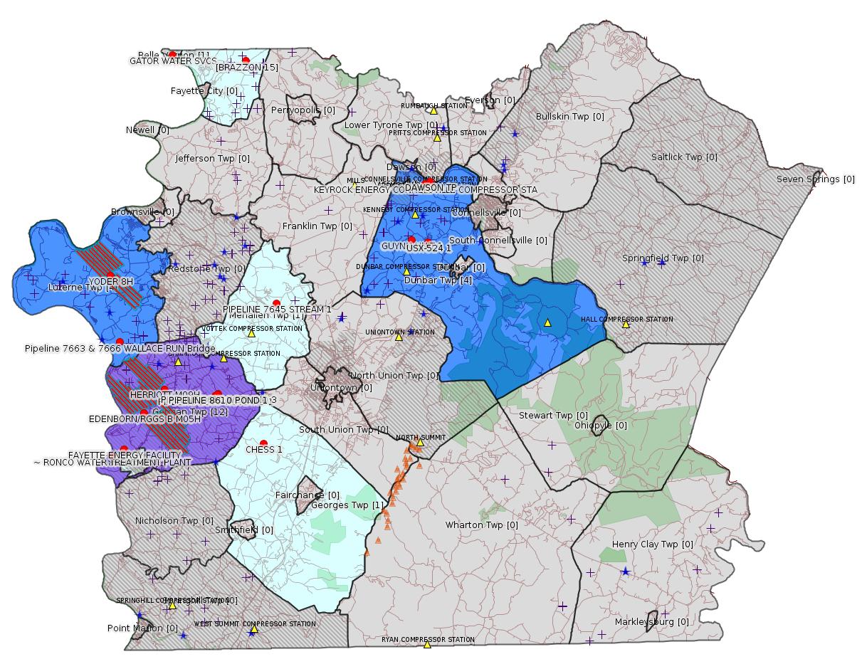
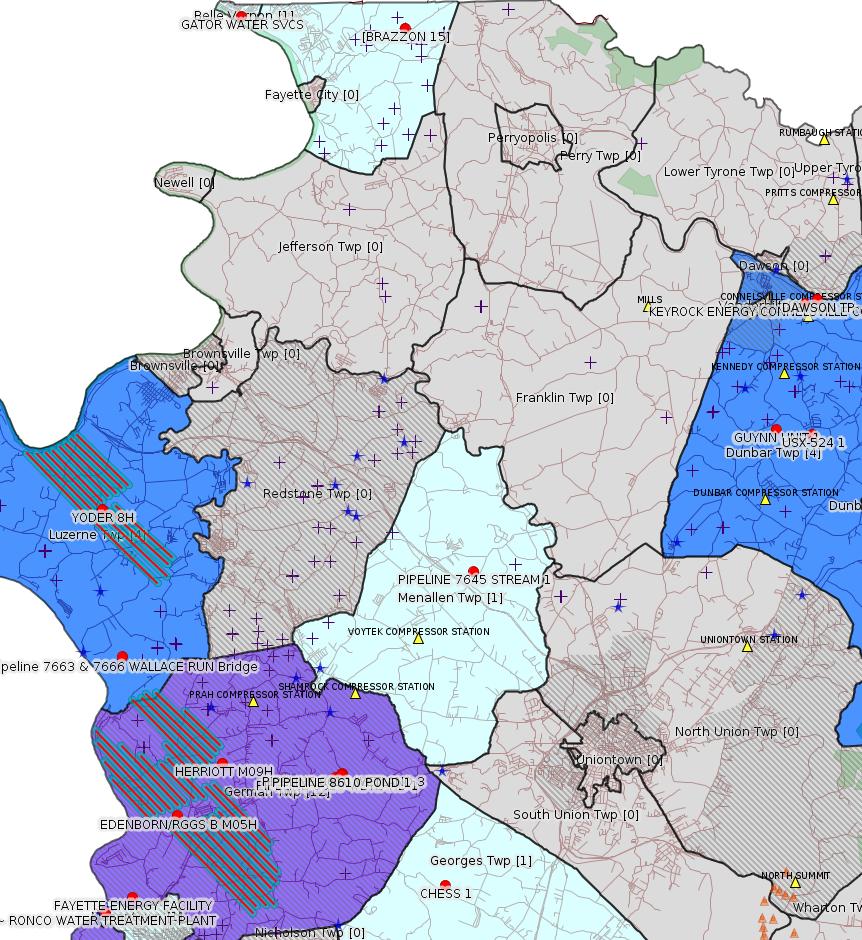
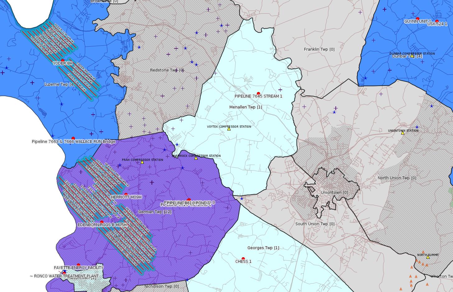
Map
Key
Red dots: items in this permit list with an exact location.
Blue stars: Marcellus Gas Well Water Sources.
Where well laterals are mapped they show in red; a 400-foot buffer surrounding the lateral shows in blue (lavender where it overlaps a mapped mineral tract).
Where mineral tracts are mapped, they show in pink. Mineral tracts can overlap; the overlap will show in red. The precise meaning of "mineral tract" is not clear.
Municipality shading: number of "facilities", with each well counting separately
(includes the red dots):
gray: 0
pale turquoise: 1
turquoise: 2
pale blue: 3
middle blue: 4
dark blue: 5
dark purple: 12
purple: 19
(Color coding may differ from one issue to the next.)
(Note if a project spans multiple municipalities -- e.g. a pipeline -- it will show in the count for each municipality.)
The number of facilities also follows the municipality name in brackets.
Municipality counts are based on the way the permit is listed by DEP; DEP has been known to get a municipality wrong.
Locations in brackets identify a precise location used to locate a surrogate for the actual site being permitted (e.g. locating a well pad or pipeline by the known location of a well.) Locations labeled beginning with "~" and ending in "[?]" are approximate and speculative based on inferences using on-line property and lease records. These are marked in the text as "[Approximate, Speculative]
Cross-hatching: Environmental Justice Areas
Yellow triangles: Compressor Stations
Orange triangles: Storage Field Wells (currently Dominion North Summit Storage Field)
Crosses: SPUD Unconventional well permits
Green: "Natural areas", e.g. state game lands, state forests
Yellow triangles: Compressor Stations
Orange triangles: Storage Field Wells (currently Dominion North Summit Storage Field)
Crosses: SPUD Unconventional well permits
Green: "Natural areas", e.g. state game lands, state forests
More Maps
 |
 |
Source: Pennsylvania Bulletin
https://www.pabulletin.com/secure/data/vol49/49-30/1144.html>
Sub-Facilities for Authorization:
Sub-Facility ID Sub-Facility Name Description
1025459 OUTFALL 001 Discharge Point
Location: 40.036247,-79.640533
Map URL: <http://www.openstreetmap.org/?mlat=40.036247&mlon=-79.640533#map=15/40.036247/-79.640533>
-------------------------Sub-Facility ID Sub-Facility Name Description
1025459 OUTFALL 001 Discharge Point
Location: 40.036247,-79.640533
Map URL: <http://www.openstreetmap.org/?mlat=40.036247&mlon=-79.640533#map=15/40.036247/-79.640533>
Source: eNOTICE
(+ PA
Oil and Gas Mapping, Well
Pad Report.) Well Details via Data
Portal Services: Oil and Gas Wells All (ID: 3).
Please see the Disclaimer below regarding Parcel Id data.
Authorization ID: 1281403
Permit number: GP112607219-016
Site: BRAZZON 15 ACCESS RD CULVERT REPLACEMENT PROJ GP11
Client: DIVERSIFIED OIL & GAS LLC
Authorization type: BWM-GP-11 Maintenance, Testing, Repair, Rehabilitation or Replacement General Pmt
Application type: New
Authorization is for: FACILITY
Date received: 07/23/2019
Status: Pending
Permit Decision Guarantee Applies?: Yes
Permit Decision Guarantee status: ACTIVE
Sub-Facilities for Authorization:
Sub-Facility ID Sub-Facility Name Description
1291040 BRAZZON 15 ACCESS RD CULVERT REPLACEMENT GP11 Other Activities
<https://www.ahs.dep.pa.gov/eFACTSWeb/searchResults_singleAuth.aspx?AuthID=1281403>
Site Programs:
Water Planning and Conservation
Site Municipalities:
Washington Twp, Fayette County
Well Details [of BRAZZON 15]:
Permit Number: 051-23977
Well Name: BRAZZON 15
Unconventional Well: Y
Well Configuration: Vertical Well
Well Type: GAS
Well Status: Active
Coal Association: Coal
Conservation Well: Y
Primary Facility ID: 705611
Site ID: 704775
Site Name: BRAZZON 15 OG WELL
Well Pad ID: 147068
Well Pad Name: BRAZZON 15
Storage Field:
Operator: DIVERSIFIED OIL & GAS LLC
Operator Number: OGO-68792
Permit Date: 2008-05-09
Permit Date Expires: 2009-05-09
SPUD Date: 2008-06-02
Date Plugged:
UIC ID:
UIC Type:
Surface Elevation: 1015
County: Fayette
Municipality: Washington Twp
Location: 40.120332,-79.801974
Map URL: <http://www.openstreetmap.org/?mlat=40.120332&mlon=-79.801974#map=15/40.120332/-79.801974>
---
Authorization ID: 1280692
Permit number: 051-20785
Site: USX-524 1 WELL
Client: AMER EXPLORATION CO
Authorization type: Well Plugging Notice Alternate Method
Application type: New
Authorization is for: FACILITY
Date received: 07/17/2019
Status: Pending
Permit Decision Guarantee Applies?: No
Sub-Facilities for Authorization:
Sub-Facility ID Sub-Facility Name Description
56962 USX-524 1 Well
Permit Review Notes:
Date Review Note
7/17/2019 The permit application package is complete, has been accepted, and is undergoing technical review.
<https://www.ahs.dep.pa.gov/eFACTSWeb/searchResults_singleAuth.aspx?AuthID=1280692>
Site Programs:
Oil & Gas
Site Municipalities:
Dunbar Twp, Fayette County
Well Details:
Permit Number: 051-20785
Well Name: USX-524 1
Unconventional Well: N
Well Configuration: Vertical Well
Well Type: GAS
Well Status: Active
Coal Association: NonCoal
Conservation Well: N
Primary Facility ID: 43432
Site ID: 41680
Site Name: USX-524 1 WELL
Well Pad ID: 0
Well Pad Name:
Storage Field:
Operator: AMER EXPLORATION CO
Operator Number: OGO-49725
Permit Date: 1995-07-07
Permit Date Expires: 1996-07-07
SPUD Date: 1995-07-10
Date Plugged:
UIC ID:
UIC Type:
Surface Elevation: 1060
County: Fayette
Municipality: Dunbar Twp
Location: 39.995084,-79.643142
Map URL: <http://www.openstreetmap.org/?mlat=39.995084&mlon=-79.643142#map=15/39.995084/-79.643142>
Presumed Parcel Id: 09240255
---
Authorization ID: 1280690
Permit number: 051-20785
Site: USX-524 1 WELL
Client: AMER EXPLORATION CO
Authorization type: Well Plugging Notice Intent to Plug Single Well
Application type: New
Authorization is for: FACILITY
Date received: 07/17/2019
Status: Pending
Permit Decision Guarantee Applies?: No
Sub-Facilities for Authorization:
Sub-Facility ID Sub-Facility Name Description
56962 USX-524 1 Well
Permit Review Notes:
Date Review Note
7/17/2019 The permit application package is complete, has been accepted, and is undergoing technical review.
<https://www.ahs.dep.pa.gov/eFACTSWeb/searchResults_singleAuth.aspx?AuthID=1280690>
Site Programs:
Oil & Gas
Site Municipalities:
Dunbar Twp, Fayette County
Well Details above
---
Authorization ID: 1280686
Permit number: 051-20842
Site: GUYNN UNIT 1 Well
Client: AMER EXPLORATION CO
Authorization type: Well Plugging Notice Alternate Method
Application type: New
Authorization is for: FACILITY
Date received: 07/17/2019
Status: Pending
Permit Decision Guarantee Applies?: No
Sub-Facilities for Authorization:
Sub-Facility ID Sub-Facility Name Description
313107 GUYNN UNIT 1 Well
Permit Review Notes:
Date Review Note
7/17/2019 The permit application package is complete, has been accepted, and is undergoing technical review.
<https://www.ahs.dep.pa.gov/eFACTSWeb/searchResults_singleAuth.aspx?AuthID=1280686>
Site Programs:
Oil & Gas
Site Municipalities:
Dunbar Twp, Fayette County
Well Details:
Permit Number: 051-20842
Well Name: GUYNN UNIT 1
Unconventional Well: N
Well Configuration: Vertical Well
Well Type: GAS
Well Status: Active
Coal Association: Coal
Conservation Well: N
Primary Facility ID: 332166
Site ID: 308946
Site Name: GUYNN UNIT 1 Well
Well Pad ID: 0
Well Pad Name:
Storage Field:
Operator: AMER EXPLORATION CO
Operator Number: OGO-49725
Permit Date: 1996-07-22
Permit Date Expires: 1997-07-22
SPUD Date: 1996-07-24
Date Plugged:
UIC ID:
UIC Type:
Surface Elevation: 1145
County: Fayette
Municipality: Dunbar Twp
Location: 39.996731,-79.657603
Map URL: <http://www.openstreetmap.org/?mlat=39.996731&mlon=-79.657603#map=15/39.996731/-79.657603>
Presumed Parcel Id: 09240001
---
Authorization ID: 1280684
Permit number: 051-20842
Site: GUYNN UNIT 1 Well
Client: AMER EXPLORATION CO
Authorization type: Well Plugging Notice Intent to Plug Single Well
Application type: New
Authorization is for: FACILITY
Date received: 07/17/2019
Status: Pending
Permit Decision Guarantee Applies?: No
Sub-Facilities for Authorization:
Sub-Facility ID Sub-Facility Name Description
313107 GUYNN UNIT 1 Well
Permit Review Notes:
Date Review Note
7/17/2019 The permit application package is complete, has been accepted, and is undergoing technical review.
<https://www.ahs.dep.pa.gov/eFACTSWeb/searchResults_singleAuth.aspx?AuthID=1280684>
Site Programs:
Oil & Gas
Site Municipalities:
Dunbar Twp, Fayette County
Well Details above
---
Authorization ID: 1280621
Permit number: 26-00535B
Site: FAYETTE ENERGY FACILITY
Client: DYNEGY FAYETTE II, LLC
Authorization type: Major Facility Plan Approval New Source Performance Std
Application type: Extension
Authorization is for: FACILITY
Date received: 07/16/2019
Status: Pending
Permit Decision Guarantee Applies?: No
Permit Review Notes:
Date Review Note
7/17/2019 The permit application package is complete, has been accepted, and is undergoing technical review.
<https://www.ahs.dep.pa.gov/eFACTSWeb/searchResults_singleAuth.aspx?AuthID=1280621>
Site Programs:
Air Quality
Waste Management
Water Planning and Conservation
Site Municipalities:
German Twp [an Environmental Justice Area], Fayette County
Masontown Boro [incorrect -jr], Fayette County
---
Authorization ID: 1280553
Permit number: GP042605219-001
Site: GATOR WATER SVCS
Client: GATOR WATER SVCS
Authorization type: GP-04 Intake & Outfall Structures
Application type: New
Authorization is for: FACILITY
Date received: 07/11/2019
Status: Pending
Permit Decision Guarantee Applies?: No
Sub-Facilities for Authorization:
Sub-Facility ID Sub-Facility Name Description
1290477 WITHDRAWAL DISTRIBUTION Intake Structure
Location: 40.1246,-79.8666
Map URL: <http://www.openstreetmap.org/?mlat=40.1246&mlon=-79.8666#map=15/40.1246/-79.8666>
<https://www.ahs.dep.pa.gov/eFACTSWeb/searchResults_singleAuth.aspx?AuthID=1280553>
Site Programs:
Water Planning and Conservation
Site Municipalities:
Belle Vernon Boro, Fayette County
Presumed Parcel Id: 01040223
[See Notes.]
---
Authorization ID: 1279814
Permit number: 051-24665
Site: CHESS 1H ESCGP-EXPEDITED
Client: INR OPR LLC
Authorization type: Drill & Operate Well Permit (Conventional)
Application type: Renewal
Authorization is for: FACILITY
Date received: 07/10/2019
Status: Withdrawn on 7/17/2019
Permit Decision Guarantee Applies?: No
Sub-Facilities for Authorization:
Sub-Facility ID Sub-Facility Name Description
1261677 WELLBORE SURFACE HOLE LOCATION Well
<https://www.ahs.dep.pa.gov/eFACTSWeb/searchResults_singleAuth.aspx?AuthID=1279814>
Site Programs:
Oil & Gas
Site Municipalities:
Georges Twp, Fayette County
Well Details:
Permit Number: 051-24665
Well Name: CHESS 1
Unconventional Well: N
Well Configuration: Vertical Well
Well Type: GAS
Well Status: Active
Coal Association: Coal
Conservation Well: Y
Primary Facility ID: 827530
Site ID: 735899
Site Name: CHESS 1H ESCGP-EXPEDITED
Well Pad ID: 154471
Well Pad Name: CHESS 1
Storage Field:
Operator: INR OPR LLC
Operator Number: OGO-51036
Permit Date: 2018-08-02
Permit Date Expires: 2019-08-02
SPUD Date:
Date Plugged:
UIC ID:
UIC Type:
Surface Elevation: 1183
County: Fayette
Municipality: Georges Twp
Location: 39.859844,-79.7907
Map URL: <http://www.openstreetmap.org/?mlat=39.859844&mlon=-79.7907#map=15/39.859844/-79.7907>
OG WELLS PERMIT DOCS:
2018-08-03: Other Permit Documents, Name: RE Notification of unlocked authorization request - Authorization ID 1234983 (for Authorization: 1234983):
<http://www.depgis.state.pa.us/pdfHandler/pdFHandler.ashx?Doc=NjQyMjA5&ext=PDF>
2018-08-03: Final Permit Documents, Name: 1234983 (for Authorization: 1234983):
<http://www.depgis.state.pa.us/pdfHandler/pdFHandler.ashx?Doc=NjQ2NzMy&ext=PDF>
2019-07-17: Initial Submitted Documents, Name: 1279814 (for Authorization: 1279814):
<http://www.depgis.state.pa.us/pdfHandler/pdFHandler.ashx?Doc=ODY4NjQ1&ext=PDF>
2019-07-17: Other Permit Documents, Name: External INR Operating LLC Chess 1H Well Permit Renewal (for Authorization: 1279814):
<http://www.depgis.state.pa.us/pdfHandler/pdFHandler.ashx?Doc=ODcwNzQ5&ext=PDF>
Electronically Submitted Records:
2018-08-03: Submission for Authorization 1234983
Pennsylvania Natural Diversity Inventory Form: project_receipt_chess_1_well_658428_FINAL_1.pdf
<http://www.depgis.state.pa.us/eWellDocHandler/pdFHandler.ashx?Doc=NTc5MzQ2&ext=PDF>
Location Plat: CHESS 1_3702.dwg
<http://www.depgis.state.pa.us/eWellDocHandler/pdFHandler.ashx?Doc=NjEwNzU2&ext=PDF>
Permit Application to Drill and Operate a Well: 1764208.pdf
<http://www.depgis.state.pa.us/eWellDocHandler/pdFHandler.ashx?Doc=NjEwNzU5&ext=PDF>
Authorization ID: 1277911
Permit number: GP5-26-00544C
Site: KEYROCK ENERGY CONNELSVILLE COMPRESSOR STA
Client: KEYROCK ENERGY LLC
Authorization type: AQ GP 5 - Natural Gas Compression and/or Processing Facilities
Application type: New
Authorization is for: FACILITY
Date received: 06/21/2019
Status: Pending
Permit Decision Guarantee Applies?: No
Permit Review Notes:
Date Review Note
6/24/2019 The permit application package is complete, has been accepted, and is undergoing technical review.
<https://www.ahs.dep.pa.gov/eFACTSWeb/searchResults_singleAuth.aspx?AuthID=1277911>
Site Programs:
Air Quality
Site Municipalities:
Dunbar Twp, Fayette County
---
Authorization ID: 1275516
Permit number: 051-24705
Site: HERRIOTT PAD A WELL AND TANK SITE ESCGP ESX18-051-0002
Client: CHEVRON APPALACHIA LLC
Authorization type: Alt Method of Equipping, Casing, or Venting Well
Application type: New
Authorization is for: FACILITY
Date received: 06/04/2019
Status: Issued on 7/23/2019
Permit Decision Guarantee Applies?: Yes
Permit Decision Guarantee status: ACTIVE
Sub-Facilities for Authorization:
Sub-Facility ID Sub-Facility Name Description
1280824 WELLBORE SURFACE HOLE LOCATION Well
Permit Review Notes:
Date Review Note
7/23/2019 The technical review and decision review are complete and either the permit decision and/or permit issuance are forthcoming.
6/5/2019 The permit application package is complete, has been accepted, and is undergoing technical review.
<https://www.ahs.dep.pa.gov/eFACTSWeb/searchResults_singleAuth.aspx?AuthID=1275516>
Site Programs:
Oil & Gas
Site Municipalities:
German Twp [an Environmental Justice Area], Fayette County
Well Details:
Permit Number: 051-24705
Well Name: HERRIOTT M09H
Unconventional Well: Y
Well Configuration: Horizontal Well
Well Type: GAS
Well Status: Active
Coal Association: Coal
Conservation Well: N
Primary Facility ID: 832297
Site ID: 829399
Site Name: HERRIOTT PAD A WELL AND TANK SITE ESCGP ESX18-051-0002
Well Pad ID: 155082
Well Pad Name: HERRIOTT
Storage Field:
Operator: CHEVRON APPALACHIA LLC
Operator Number: OGO-39307
Permit Date: 2019-02-22
Permit Date Expires: 2020-02-22
SPUD Date: 2019-06-21
Date Plugged:
UIC ID:
UIC Type:
Surface Elevation: 1265
County: Fayette
Municipality: German Twp
Location: 39.897794,-79.877717
Map URL: <http://www.openstreetmap.org/?mlat=39.897794&mlon=-79.877717#map=15/39.897794/-79.877717>
OG WELLS PERMIT DOCS:
2019-02-22: Final Permit Documents, Name: auth id 1260912 (for Authorization: 1260912):
<http://www.depgis.state.pa.us/pdfHandler/pdFHandler.ashx?Doc=NzU0NDY4&ext=PDF>
2019-07-23: Other Permit Documents, Name: Alternate Method (for Authorization: 1275516):
<http://www.depgis.state.pa.us/pdfHandler/pdFHandler.ashx?Doc=ODgwOTYz&ext=PDF>
Electronically Submitted Records:
2019-02-22: Submission for Authorization 1260912
Location Plat: 172-319-Well Plat M09H-pages1-2-3_3702.dwg
<http://www.depgis.state.pa.us/eWellDocHandler/pdFHandler.ashx?Doc=NzYzMDg2&ext=PDF>
Pennsylvania Natural Diversity Inventory Form: Herriott PNDI.pdf
<http://www.depgis.state.pa.us/eWellDocHandler/pdFHandler.ashx?Doc=NzYzMDg3&ext=PDF>
Well Cross-Section Diagram: Herriott M09H Page 4.pdf
<http://www.depgis.state.pa.us/eWellDocHandler/pdFHandler.ashx?Doc=NzYzMDg5&ext=PDF>
Coal and Gas Resource Coord Act - Section 7 Exception: Herriott Section 7 Exception.pdf
<http://www.depgis.state.pa.us/eWellDocHandler/pdFHandler.ashx?Doc=NzY4NDg0&ext=PDF>
Permit Application to Drill and Operate a Well: 1865932.pdf
<http://www.depgis.state.pa.us/eWellDocHandler/pdFHandler.ashx?Doc=NzY4NTEx&ext=PDF>
---
Authorization ID: 1275515
Permit number: 051-24703
Site: HERRIOTT PAD A WELL AND TANK SITE ESCGP ESX18-051-0002
Client: CHEVRON APPALACHIA LLC
Authorization type: Alt Method of Equipping, Casing, or Venting Well
Application type: New
Authorization is for: FACILITY
Date received: 06/04/2019
Status: Issued on 7/23/2019
Permit Decision Guarantee Applies?: Yes
Permit Decision Guarantee status: ACTIVE
Sub-Facilities for Authorization:
Sub-Facility ID Sub-Facility Name Description
1280822 WELLBORE SURFACE HOLE LOCATION Well
Permit Review Notes:
Date Review Note
7/23/2019 The technical review and decision review are complete and either the permit decision and/or permit issuance are forthcoming.
6/5/2019 The permit application package is complete, has been accepted, and is undergoing technical review.
<https://www.ahs.dep.pa.gov/eFACTSWeb/searchResults_singleAuth.aspx?AuthID=1275515>
Site Programs:
Oil & Gas
Site Municipalities:
German Twp [an Environmental Justice Area], Fayette County
Well Details:
Permit Number: 051-24703
Well Name: HERRIOTT M08H
Unconventional Well: Y
Well Configuration: Horizontal Well
Well Type: GAS
Well Status: Active
Coal Association: Coal
Conservation Well: N
Primary Facility ID: 832295
Site ID: 829399
Site Name: HERRIOTT PAD A WELL AND TANK SITE ESCGP ESX18-051-0002
Well Pad ID: 155082
Well Pad Name: HERRIOTT
Storage Field:
Operator: CHEVRON APPALACHIA LLC
Operator Number: OGO-39307
Permit Date: 2019-02-22
Permit Date Expires: 2020-02-22
SPUD Date: 2019-06-21
Date Plugged:
UIC ID:
UIC Type:
Surface Elevation: 1265
County: Fayette
Municipality: German Twp
Location: 39.897769,-79.877817
Map URL: <http://www.openstreetmap.org/?mlat=39.897769&mlon=-79.877817#map=15/39.897769/-79.877817>
OG WELLS PERMIT DOCS:
2019-02-22: Final Permit Documents, Name: auth id 1260910 (for Authorization: 1260910):
<http://www.depgis.state.pa.us/pdfHandler/pdFHandler.ashx?Doc=NzU0NDcw&ext=PDF>
2019-07-23: Other Permit Documents, Name: Alternate Method (for Authorization: 1275515):
<http://www.depgis.state.pa.us/pdfHandler/pdFHandler.ashx?Doc=ODgwOTU5&ext=PDF>
Electronically Submitted Records:
2019-02-22: Submission for Authorization 1260910
Location Plat: 172-319-Well Plat M08H-pages1-2-3_3702.dwg
<http://www.depgis.state.pa.us/eWellDocHandler/pdFHandler.ashx?Doc=NzYzMDMw&ext=PDF>
Pennsylvania Natural Diversity Inventory Form: Herriott PNDI.pdf
<http://www.depgis.state.pa.us/eWellDocHandler/pdFHandler.ashx?Doc=NzYzMDMx&ext=PDF>
Well Cross-Section Diagram: Herriott M08H Page 4.pdf
<http://www.depgis.state.pa.us/eWellDocHandler/pdFHandler.ashx?Doc=NzYzMDMz&ext=PDF>
Coal and Gas Resource Coord Act - Section 7 Exception: Herriott Section 7 Exception.pdf
<http://www.depgis.state.pa.us/eWellDocHandler/pdFHandler.ashx?Doc=NzY4NDc2&ext=PDF>
Permit Application to Drill and Operate a Well: 1865928.pdf
<http://www.depgis.state.pa.us/eWellDocHandler/pdFHandler.ashx?Doc=NzY4NTAy&ext=PDF>
---
Authorization ID: 1275511
Permit number: 051-24702
Site: HERRIOTT PAD A WELL AND TANK SITE ESCGP ESX18-051-0002
Client: CHEVRON APPALACHIA LLC
Authorization type: Alt Method of Equipping, Casing, or Venting Well
Application type: New
Authorization is for: FACILITY
Date received: 06/04/2019
Status: Issued on 7/23/2019
Permit Decision Guarantee Applies?: Yes
Permit Decision Guarantee status: ACTIVE
Sub-Facilities for Authorization:
Sub-Facility ID Sub-Facility Name Description
1280821 WELLBORE SURFACE HOLE LOCATION Well
Permit Review Notes:
Date Review Note
7/23/2019 The technical review and decision review are complete and either the permit decision and/or permit issuance are forthcoming.
6/5/2019 The permit application package is complete, has been accepted, and is undergoing technical review.
<https://www.ahs.dep.pa.gov/eFACTSWeb/searchResults_singleAuth.aspx?AuthID=1275511>
Site Programs:
Oil & Gas
Site Municipalities:
German Twp [an Environmental Justice Area], Fayette County
Well Details:
Permit Number: 051-24702
Well Name: HERRIOTT M07H
Unconventional Well: Y
Well Configuration: Horizontal Well
Well Type: GAS
Well Status: Active
Coal Association: Coal
Conservation Well: N
Primary Facility ID: 832294
Site ID: 829399
Site Name: HERRIOTT PAD A WELL AND TANK SITE ESCGP ESX18-051-0002
Well Pad ID: 155082
Well Pad Name: HERRIOTT
Storage Field:
Operator: CHEVRON APPALACHIA LLC
Operator Number: OGO-39307
Permit Date: 2019-02-22
Permit Date Expires: 2020-02-22
SPUD Date: 2019-06-20
Date Plugged:
UIC ID:
UIC Type:
Surface Elevation: 1265
County: Fayette
Municipality: German Twp
Location: 39.897808,-79.877833
Map URL: <http://www.openstreetmap.org/?mlat=39.897808&mlon=-79.877833#map=15/39.897808/-79.877833>
OG WELLS PERMIT DOCS:
2019-02-22: Final Permit Documents, Name: auth id 1260909 (for Authorization: 1260909):
<http://www.depgis.state.pa.us/pdfHandler/pdFHandler.ashx?Doc=NzU0NDcx&ext=PDF>
2019-07-23: Other Permit Documents, Name: Alternate Method (for Authorization: 1275511):
<http://www.depgis.state.pa.us/pdfHandler/pdFHandler.ashx?Doc=ODgwOTQ4&ext=PDF>
Electronically Submitted Records:
2019-02-22: Submission for Authorization 1260909
Pennsylvania Natural Diversity Inventory Form: Herriott PNDI.pdf
<http://www.depgis.state.pa.us/eWellDocHandler/pdFHandler.ashx?Doc=NzYzMDAz&ext=PDF>
Location Plat: 172-319-Well Plat M07H-pages1-2-3_3702.dwg
<http://www.depgis.state.pa.us/eWellDocHandler/pdFHandler.ashx?Doc=NzYzMDA0&ext=PDF>
Well Cross-Section Diagram: Herriott M07H Page 4.pdf
<http://www.depgis.state.pa.us/eWellDocHandler/pdFHandler.ashx?Doc=NzYzMDA2&ext=PDF>
Coal and Gas Resource Coord Act - Section 7 Exception: Herriott Section 7 Exception.pdf
<http://www.depgis.state.pa.us/eWellDocHandler/pdFHandler.ashx?Doc=NzY4NDc1&ext=PDF>
Permit Application to Drill and Operate a Well: 1865905.pdf
<http://www.depgis.state.pa.us/eWellDocHandler/pdFHandler.ashx?Doc=NzY4NTA1&ext=PDF>
---
Authorization ID: 1275510
Permit number: 051-24700
Site: HERRIOTT PAD A WELL AND TANK SITE ESCGP ESX18-051-0002
Client: CHEVRON APPALACHIA LLC
Authorization type: Alt Method of Equipping, Casing, or Venting Well
Application type: New
Authorization is for: FACILITY
Date received: 06/04/2019
Status: Issued on 7/23/2019
Permit Decision Guarantee Applies?: Yes
Permit Decision Guarantee status: ACTIVE
Sub-Facilities for Authorization:
Sub-Facility ID Sub-Facility Name Description
1280819 WELLBORE SURFACE HOLE LOCATION Well
Permit Review Notes:
Date Review Note
7/23/2019 The technical review and decision review are complete and either the permit decision and/or permit issuance are forthcoming.
6/5/2019 The permit application package is complete, has been accepted, and is undergoing technical review.
<https://www.ahs.dep.pa.gov/eFACTSWeb/searchResults_singleAuth.aspx?AuthID=1275510>
Site Programs:
Oil & Gas
Site Municipalities:
German Twp [an Environmental Justice Area], Fayette County
Well Details:
Permit Number: 051-24700
Well Name: HERRIOTT M06H
Unconventional Well: Y
Well Configuration: Horizontal Well
Well Type: GAS
Well Status: Active
Coal Association: Coal
Conservation Well: N
Primary Facility ID: 832292
Site ID: 829399
Site Name: HERRIOTT PAD A WELL AND TANK SITE ESCGP ESX18-051-0002
Well Pad ID: 155082
Well Pad Name: HERRIOTT
Storage Field:
Operator: CHEVRON APPALACHIA LLC
Operator Number: OGO-39307
Permit Date: 2019-02-22
Permit Date Expires: 2020-02-22
SPUD Date: 2019-06-20
Date Plugged:
UIC ID:
UIC Type:
Surface Elevation: 1265
County: Fayette
Municipality: German Twp
Location: 39.897847,-79.87785
Map URL: <http://www.openstreetmap.org/?mlat=39.897847&mlon=-79.87785#map=15/39.897847/-79.87785>
OG WELLS PERMIT DOCS:
2019-02-22: Final Permit Documents, Name: auth id 1260907 (for Authorization: 1260907):
<http://www.depgis.state.pa.us/pdfHandler/pdFHandler.ashx?Doc=NzU0NDcz&ext=PDF>
2019-07-23: Other Permit Documents, Name: Alternate Method (for Authorization: 1275510):
<http://www.depgis.state.pa.us/pdfHandler/pdFHandler.ashx?Doc=ODgwOTQ3&ext=PDF>
Electronically Submitted Records:
2019-02-22: Submission for Authorization 1260907
Pennsylvania Natural Diversity Inventory Form: Herriott PNDI.pdf
<http://www.depgis.state.pa.us/eWellDocHandler/pdFHandler.ashx?Doc=NzYyOTgz&ext=PDF>
Location Plat: 172-319-Well Plat M06H-pages1-2-3_3702.dwg
<http://www.depgis.state.pa.us/eWellDocHandler/pdFHandler.ashx?Doc=NzYyOTg0&ext=PDF>
Well Cross-Section Diagram: Herriott M06H Page 4.pdf
<http://www.depgis.state.pa.us/eWellDocHandler/pdFHandler.ashx?Doc=NzYyOTg2&ext=PDF>
Coal and Gas Resource Coord Act - Section 7 Exception: Herriott Section 7 Exception.pdf
<http://www.depgis.state.pa.us/eWellDocHandler/pdFHandler.ashx?Doc=NzY4MzQ0&ext=PDF>
Permit Application to Drill and Operate a Well: 1865896.pdf
<http://www.depgis.state.pa.us/eWellDocHandler/pdFHandler.ashx?Doc=NzY4NDkz&ext=PDF>
---
Authorization ID: 1275509
Permit number: 051-24699
Site: HERRIOTT PAD A WELL AND TANK SITE ESCGP ESX18-051-0002
Client: CHEVRON APPALACHIA LLC
Authorization type: Alt Method of Equipping, Casing, or Venting Well
Application type: New
Authorization is for: FACILITY
Date received: 06/04/2019
Status: Issued on 7/23/2019
Permit Decision Guarantee Applies?: Yes
Permit Decision Guarantee status: ACTIVE
Sub-Facilities for Authorization:
Sub-Facility ID Sub-Facility Name Description
1280818 WELLBORE SURFACE HOLE LOCATION Well
Permit Review Notes:
Date Review Note
7/23/2019 The technical review and decision review are complete and either the permit decision and/or permit issuance are forthcoming.
6/5/2019 The permit application package is complete, has been accepted, and is undergoing technical review.
<https://www.ahs.dep.pa.gov/eFACTSWeb/searchResults_singleAuth.aspx?AuthID=1275509>
Site Programs:
Oil & Gas
Site Municipalities:
German Twp [an Environmental Justice Area], Fayette County
Well Details:
Permit Number: 051-24699
Well Name: HERRIOTT M05H
Unconventional Well: Y
Well Configuration: Horizontal Well
Well Type: GAS
Well Status: Active
Coal Association: Coal
Conservation Well: N
Primary Facility ID: 832291
Site ID: 829399
Site Name: HERRIOTT PAD A WELL AND TANK SITE ESCGP ESX18-051-0002
Well Pad ID: 155082
Well Pad Name: HERRIOTT
Storage Field:
Operator: CHEVRON APPALACHIA LLC
Operator Number: OGO-39307
Permit Date: 2019-02-22
Permit Date Expires: 2020-02-22
SPUD Date: 2019-06-19
Date Plugged:
UIC ID:
UIC Type:
Surface Elevation: 1265
County: Fayette
Municipality: German Twp
Location: 39.897886,-79.877869
Map URL: <http://www.openstreetmap.org/?mlat=39.897886&mlon=-79.877869#map=15/39.897886/-79.877869>
OG WELLS PERMIT DOCS:
2019-02-22: Final Permit Documents, Name: 051-24699 (for Authorization: 1260905):
<http://www.depgis.state.pa.us/pdfHandler/pdFHandler.ashx?Doc=NzU3Mzc1&ext=PDF>
2019-07-23: Other Permit Documents, Name: Alternate Method (for Authorization: 1275509):
<http://www.depgis.state.pa.us/pdfHandler/pdFHandler.ashx?Doc=ODgwOTQ2&ext=PDF>
Electronically Submitted Records:
2019-02-22: Submission for Authorization 1260905
Location Plat: 172-319-Well Plat M05H-pages1-2-3_3702.dwg
<http://www.depgis.state.pa.us/eWellDocHandler/pdFHandler.ashx?Doc=NzYyOTcw&ext=PDF>
Pennsylvania Natural Diversity Inventory Form: Herriott PNDI.pdf
<http://www.depgis.state.pa.us/eWellDocHandler/pdFHandler.ashx?Doc=NzYyOTcx&ext=PDF>
Well Cross-Section Diagram: Herriott M05H Page 4.pdf
<http://www.depgis.state.pa.us/eWellDocHandler/pdFHandler.ashx?Doc=NzYyOTcy&ext=PDF>
Coal and Gas Resource Coord Act - Section 7 Exception: Herriott Section 7 Exception.pdf
<http://www.depgis.state.pa.us/eWellDocHandler/pdFHandler.ashx?Doc=NzY4MzQy&ext=PDF>
Permit Application to Drill and Operate a Well: 1865638.pdf
<http://www.depgis.state.pa.us/eWellDocHandler/pdFHandler.ashx?Doc=NzY4NDkw&ext=PDF>
---
Authorization ID: 1275508
Permit number: 051-24698
Site: HERRIOTT PAD A WELL AND TANK SITE ESCGP ESX18-051-0002
Client: CHEVRON APPALACHIA LLC
Authorization type: Alt Method of Equipping, Casing, or Venting Well
Application type: New
Authorization is for: FACILITY
Date received: 06/04/2019
Status: Issued on 7/23/2019
Permit Decision Guarantee Applies?: Yes
Permit Decision Guarantee status: ACTIVE
Sub-Facilities for Authorization:
Sub-Facility ID Sub-Facility Name Description
1280817 WELLBORE SURFACE HOLE LOCATION Well
Permit Review Notes:
Date Review Note
7/23/2019 The technical review and decision review are complete and either the permit decision and/or permit issuance are forthcoming.
6/5/2019 The permit application package is complete, has been accepted, and is undergoing technical review.
<https://www.ahs.dep.pa.gov/eFACTSWeb/searchResults_singleAuth.aspx?AuthID=1275508>
Site Programs:
Oil & Gas
Site Municipalities:
German Twp [an Environmental Justice Area], Fayette County
Well Details:
Permit Number: 051-24698
Well Name: HERRIOTT M04H
Unconventional Well: Y
Well Configuration: Horizontal Well
Well Type: GAS
Well Status: Active
Coal Association: Coal
Conservation Well: N
Primary Facility ID: 832290
Site ID: 829399
Site Name: HERRIOTT PAD A WELL AND TANK SITE ESCGP ESX18-051-0002
Well Pad ID: 155082
Well Pad Name: HERRIOTT
Storage Field:
Operator: CHEVRON APPALACHIA LLC
Operator Number: OGO-39307
Permit Date: 2019-02-22
Permit Date Expires: 2020-02-22
SPUD Date: 2019-06-19
Date Plugged:
UIC ID:
UIC Type:
Surface Elevation: 1265
County: Fayette
Municipality: German Twp
Location: 39.897925,-79.877886
Map URL: <http://www.openstreetmap.org/?mlat=39.897925&mlon=-79.877886#map=15/39.897925/-79.877886>
OG WELLS PERMIT DOCS:
2019-02-22: Final Permit Documents, Name: auth id 1260904 (for Authorization: 1260904):
<http://www.depgis.state.pa.us/pdfHandler/pdFHandler.ashx?Doc=NzU0NDc2&ext=PDF>
2019-07-23: Other Permit Documents, Name: Alternate Method (for Authorization: 1275508):
<http://www.depgis.state.pa.us/pdfHandler/pdFHandler.ashx?Doc=ODgwOTcw&ext=PDF>
Electronically Submitted Records:
2019-02-22: Submission for Authorization 1260904
Pennsylvania Natural Diversity Inventory Form: Herriott PNDI.pdf
<http://www.depgis.state.pa.us/eWellDocHandler/pdFHandler.ashx?Doc=NzYyOTUw&ext=PDF>
Location Plat: 172-319-Well Plat M04H-pages1-2-3_3702.dwg
<http://www.depgis.state.pa.us/eWellDocHandler/pdFHandler.ashx?Doc=NzYyOTUx&ext=PDF>
Well Cross-Section Diagram: Herriott M04H Page 4.pdf
<http://www.depgis.state.pa.us/eWellDocHandler/pdFHandler.ashx?Doc=NzYyOTUz&ext=PDF>
Coal and Gas Resource Coord Act - Section 7 Exception: Herriott Section 7 Exception.pdf
<http://www.depgis.state.pa.us/eWellDocHandler/pdFHandler.ashx?Doc=NzY4MzUy&ext=PDF>
Permit Application to Drill and Operate a Well: 1865625.pdf
<http://www.depgis.state.pa.us/eWellDocHandler/pdFHandler.ashx?Doc=NzY4NTE0&ext=PDF>
---
Authorization ID: 1275507
Permit number: 051-24704
Site: HERRIOTT PAD A WELL AND TANK SITE ESCGP ESX18-051-0002
Client: CHEVRON APPALACHIA LLC
Authorization type: Alt Method of Equipping, Casing, or Venting Well
Application type: New
Authorization is for: FACILITY
Date received: 06/04/2019
Status: Issued on 7/23/2019
Permit Decision Guarantee Applies?: Yes
Permit Decision Guarantee status: ACTIVE
Sub-Facilities for Authorization:
Sub-Facility ID Sub-Facility Name Description
1280823 WELLBORE SURFACE HOLE LOCATION Well
Permit Review Notes:
Date Review Note
7/23/2019 The technical review and decision review are complete and either the permit decision and/or permit issuance are forthcoming.
6/5/2019 The permit application package is complete, has been accepted, and is undergoing technical review.
<https://www.ahs.dep.pa.gov/eFACTSWeb/searchResults_singleAuth.aspx?AuthID=1275507>
Site Programs:
Oil & Gas
Site Municipalities:
German Twp [an Environmental Justice Area], Fayette County
Well Details:
Permit Number: 051-24704
Well Name: HERRIOTT M03H
Unconventional Well: Y
Well Configuration: Horizontal Well
Well Type: GAS
Well Status: Active
Coal Association: Coal
Conservation Well: N
Primary Facility ID: 832296
Site ID: 829399
Site Name: HERRIOTT PAD A WELL AND TANK SITE ESCGP ESX18-051-0002
Well Pad ID: 155082
Well Pad Name: HERRIOTT
Storage Field:
Operator: CHEVRON APPALACHIA LLC
Operator Number: OGO-39307
Permit Date: 2019-02-22
Permit Date Expires: 2020-02-22
SPUD Date: 2019-06-18
Date Plugged:
UIC ID:
UIC Type:
Surface Elevation: 1265
County: Fayette
Municipality: German Twp
Location: 39.897964,-79.877903
Map URL: <http://www.openstreetmap.org/?mlat=39.897964&mlon=-79.877903#map=15/39.897964/-79.877903>
OG WELLS PERMIT DOCS:
2019-02-22: Final Permit Documents, Name: auth id 1260911 (for Authorization: 1260911):
<http://www.depgis.state.pa.us/pdfHandler/pdFHandler.ashx?Doc=NzU0NDY5&ext=PDF>
2019-07-23: Other Permit Documents, Name: Alternate Method (for Authorization: 1275507):
<http://www.depgis.state.pa.us/pdfHandler/pdFHandler.ashx?Doc=ODgwOTQz&ext=PDF>
Electronically Submitted Records:
2019-02-22: Submission for Authorization 1260911
Pennsylvania Natural Diversity Inventory Form: Herriott PNDI.pdf
<http://www.depgis.state.pa.us/eWellDocHandler/pdFHandler.ashx?Doc=NzYyOTM1&ext=PDF>
Location Plat: 172-319-Well Plat M03H-pages1-2-3_3702.dwg
<http://www.depgis.state.pa.us/eWellDocHandler/pdFHandler.ashx?Doc=NzYyOTM2&ext=PDF>
Well Cross-Section Diagram: Herriott M03H Page 4.pdf
<http://www.depgis.state.pa.us/eWellDocHandler/pdFHandler.ashx?Doc=NzYyOTM4&ext=PDF>
Coal and Gas Resource Coord Act - Section 7 Exception: Herriott Section 7 Exception.pdf
<http://www.depgis.state.pa.us/eWellDocHandler/pdFHandler.ashx?Doc=NzY4Mzgy&ext=PDF>
Permit Application to Drill and Operate a Well: 1865616.pdf
<http://www.depgis.state.pa.us/eWellDocHandler/pdFHandler.ashx?Doc=NzY4NDk5&ext=PDF>
---
Authorization ID: 1275506
Permit number: 051-24701
Site: HERRIOTT PAD A WELL AND TANK SITE ESCGP ESX18-051-0002
Client: CHEVRON APPALACHIA LLC
Authorization type: Alt Method of Equipping, Casing, or Venting Well
Application type: New
Authorization is for: FACILITY
Date received: 06/04/2019
Status: Issued on 7/23/2019
Permit Decision Guarantee Applies?: Yes
Permit Decision Guarantee status: ACTIVE
Sub-Facilities for Authorization:
Sub-Facility ID Sub-Facility Name Description
1280820 WELLBORE SURFACE HOLE LOCATION Well
Permit Review Notes:
Date Review Note
7/23/2019 The technical review and decision review are complete and either the permit decision and/or permit issuance are forthcoming.
6/5/2019 The permit application package is complete, has been accepted, and is undergoing technical review.
<https://www.ahs.dep.pa.gov/eFACTSWeb/searchResults_singleAuth.aspx?AuthID=1275506>
Site Programs:
Oil & Gas
Site Municipalities:
German Twp [an Environmental Justice Area], Fayette County
Well Details:
Permit Number: 051-24701
Well Name: HERRIOTT M02H
Unconventional Well: Y
Well Configuration: Horizontal Well
Well Type: GAS
Well Status: Active
Coal Association: Coal
Conservation Well: N
Primary Facility ID: 832293
Site ID: 829399
Site Name: HERRIOTT PAD A WELL AND TANK SITE ESCGP ESX18-051-0002
Well Pad ID: 155082
Well Pad Name: HERRIOTT
Storage Field:
Operator: CHEVRON APPALACHIA LLC
Operator Number: OGO-39307
Permit Date: 2019-02-22
Permit Date Expires: 2020-02-22
SPUD Date: 2019-06-18
Date Plugged:
UIC ID:
UIC Type:
Surface Elevation: 1265
County: Fayette
Municipality: German Twp
Location: 39.898003,-79.877919
Map URL: <http://www.openstreetmap.org/?mlat=39.898003&mlon=-79.877919#map=15/39.898003/-79.877919>
OG WELLS PERMIT DOCS:
2019-02-22: Final Permit Documents, Name: auth id 1260908 (for Authorization: 1260908):
<http://www.depgis.state.pa.us/pdfHandler/pdFHandler.ashx?Doc=NzU0NDcy&ext=PDF>
2019-07-23: Other Permit Documents, Name: Alternate Method (for Authorization: 1275506):
<http://www.depgis.state.pa.us/pdfHandler/pdFHandler.ashx?Doc=ODgwOTc2&ext=PDF>
Electronically Submitted Records:
2019-02-22: Submission for Authorization 1260908
Pennsylvania Natural Diversity Inventory Form: Herriott PNDI.pdf
<http://www.depgis.state.pa.us/eWellDocHandler/pdFHandler.ashx?Doc=NzYyOTE4&ext=PDF>
Well Cross-Section Diagram: Herriott M02H Page 4.pdf
<http://www.depgis.state.pa.us/eWellDocHandler/pdFHandler.ashx?Doc=NzYyOTIw&ext=PDF>
Location Plat: 172-319-Well Plat M02H-pages1-2-3_3702.dwg
<http://www.depgis.state.pa.us/eWellDocHandler/pdFHandler.ashx?Doc=NzYyOTIx&ext=PDF>
Coal and Gas Resource Coord Act - Section 7 Exception: Herriott Section 7 Exception.pdf
<http://www.depgis.state.pa.us/eWellDocHandler/pdFHandler.ashx?Doc=NzY4MzQ1&ext=PDF>
Permit Application to Drill and Operate a Well: 1865609.pdf
<http://www.depgis.state.pa.us/eWellDocHandler/pdFHandler.ashx?Doc=NzY4NDk2&ext=PDF>
---
Authorization ID: 1274536
Permit number: GP112607219-014
Site: S PA GATHERING SYSTEM ABANDONMENT PPL 7663 & 7666 PROJ GP08 GP11
Client: COLUMBIA GAS TRANS
Authorization type: BWM-GP-11 Maintenance, Testing, Repair, Rehabilitation or Replacement General Pmt
Application type: New
Authorization is for: FACILITY
Date received: 05/21/2019
Status: Issued on 7/15/2019
Permit Decision Guarantee Applies?: Yes
Permit Decision Guarantee status: ACTIVE
Sub-Facilities for Authorization:
Sub-Facility ID Sub-Facility Name Description
1287626 S PA GATHERING SYS ABANDONMENT PPL 7663 AND 7666 PROJ Other Activities
1287625 WALLACE RUN Bridge
Location: 39.930465,-79.916634
Map URL: <http://www.openstreetmap.org/?mlat=39.930465&mlon=-79.916634#map=15/39.930465/-79.916634>
1290392 WALLACE RUN PIPELINE ABANDONMENT Other Activities
Location: 39.930465,-79.916634
Map URL: <http://www.openstreetmap.org/?mlat=39.930465&mlon=-79.916634#map=15/39.930465/-79.916634>
Permit Review Notes:
Date Review Note
7/15/2019 The technical review and decision review are complete and either the permit decision and/or permit issuance are forthcoming.
5/30/2019 The permit application package is complete, has been accepted, and is undergoing technical review.
<https://www.ahs.dep.pa.gov/eFACTSWeb/searchResults_singleAuth.aspx?AuthID=1274536>
Site Programs:
Water Planning and Conservation
Site Municipalities:
Luzerne Twp, Fayette County
Authorization ID: 1274535
Permit number: GP082607219-006
Site: S PA GATHERING SYSTEM ABANDONMENT PPL 7663 & 7666 PROJ GP08 GP11
Client: COLUMBIA GAS TRANS
Authorization type: GP-08 Temporary Road Crossings
Application type: New
Authorization is for: FACILITY
Date received: 05/21/2019
Status: Issued on 7/15/2019
Permit Decision Guarantee Applies?: No
Sub-Facilities for Authorization:
Sub-Facility ID Sub-Facility Name Description
1287625 WALLACE RUN Bridge
Location: 39.930465,-79.916634
Map URL: <http://www.openstreetmap.org/?mlat=39.930465&mlon=-79.916634#map=15/39.930465/-79.916634>
Permit Review Notes:
Date Review Note
7/15/2019 The technical review and decision review are complete and either the permit decision and/or permit issuance are forthcoming.
5/30/2019 The permit application package is complete, has been accepted, and is undergoing technical review.
<https://www.ahs.dep.pa.gov/eFACTSWeb/searchResults_singleAuth.aspx?AuthID=1274535>
Site Programs:
Water Planning and Conservation
Site Municipalities:
Luzerne Twp, Fayette County
Presumed Parcel Id: 19320049
---
Authorization ID: 1274532
Permit number: GP112607219-013
Site: SOUTHERN PA GATHERING SYSTEM ABANDONMENT PIPELINE 8610 PROJECT GP08 GP11
Client: COLUMBIA GAS TRANS
Authorization type: BWM-GP-11 Maintenance, Testing, Repair, Rehabilitation or Replacement General Pmt
Application type: New
Authorization is for: FACILITY
Date received: 05/23/2019
Status: Pending
Permit Decision Guarantee Applies?: Yes
Permit Decision Guarantee status: ACTIVE
Sub-Facilities for Authorization:
Sub-Facility ID Sub-Facility Name Description
1291085 POND 1- ABANDONMENT Other Activities
Location: 39.893874,-79.831128
Map URL: <http://www.openstreetmap.org/?mlat=39.893874&mlon=-79.831128#map=15/39.893874/-79.831128>
1287623 S PA GATHERING SYS ABANDONMENT PPL 8610 PROJECT GP11 Other Activities
1287622 WETLAND 1 Bridge
Location: 39.892928,-79.833191
Map URL: <http://www.openstreetmap.org/?mlat=39.892928&mlon=-79.833191#map=15/39.892928/-79.833191>
1291082 WETLAND 1 Temporary Wetland Impact
Location: 39.892928,-79.833191
Map URL: <http://www.openstreetmap.org/?mlat=39.892928&mlon=-79.833191#map=15/39.892928/-79.833191>
1291083 WETLAND 1- ABANDONMENT Wetland Impact
Location: 39.892928,-79.833191
Map URL: <http://www.openstreetmap.org/?mlat=39.892928&mlon=-79.833191#map=15/39.892928/-79.833191>
1291084 WETLAND 3- ABANDONMENT Wetland Impact
Location: 39.894175,-79.830501
Map URL: <http://www.openstreetmap.org/?mlat=39.894175&mlon=-79.830501#map=15/39.894175/-79.830501>
Permit Review Notes:
Date Review Note
7/25/2019 The technical review and decision review are complete and either the permit decision and/or permit issuance are forthcoming.
5/30/2019 The permit application package is complete, has been accepted, and is undergoing technical review.
<https://www.ahs.dep.pa.gov/eFACTSWeb/searchResults_singleAuth.aspx?AuthID=1274532>
Site Programs:
Water Planning and Conservation
Site Municipalities:
German Twp [an Environmental Justice Area], Fayette County
Presumed Parcel Id: 15280016 (Sub-Facility 1291085)
Presumed Parcel Id: 15280018 (Sub-Facilities 1287622, 1291084)
---
Authorization ID: 1274531
Permit number: GP082607219-005
Site: SOUTHERN PA GATHERING SYSTEM ABANDONMENT PIPELINE 8610 PROJECT GP08 GP11
Client: COLUMBIA GAS TRANS
Authorization type: GP-08 Temporary Road Crossings
Application type: New
Authorization is for: FACILITY
Date received: 05/23/2019
Status: Pending
Permit Decision Guarantee Applies?: No
Sub-Facilities for Authorization:
Sub-Facility ID Sub-Facility Name Description
1291082 WETLAND 1 Temporary Wetland Impact
Location: 39.892928,-79.833191
Map URL: <http://www.openstreetmap.org/?mlat=39.892928&mlon=-79.833191#map=15/39.892928/-79.833191>
1287622 WETLAND 1 Bridge
Location: 39.892928,-79.833191
Map URL: <http://www.openstreetmap.org/?mlat=39.892928&mlon=-79.833191#map=15/39.892928/-79.833191>
Permit Review Notes:
Date Review Note
7/25/2019 The technical review and decision review are complete and either the permit decision and/or permit issuance are forthcoming.
5/30/2019 The permit application package is complete, has been accepted, and is undergoing technical review.
<https://www.ahs.dep.pa.gov/eFACTSWeb/searchResults_singleAuth.aspx?AuthID=1274531>
Site Programs:
Water Planning and Conservation
Site Municipalities:
German Twp [an Environmental Justice Area], Fayette County
---
Authorization ID: 1274525
Permit number: GP112607219-012
Site: SOUTHERN PA GATHERING SYSTEM ABANDONMENT PIPELINE 7645 PROJECT GP08 GP11
Client: COLUMBIA GAS TRANS
Authorization type: BWM-GP-11 Maintenance, Testing, Repair, Rehabilitation or Replacement General Pmt
Application type: New
Authorization is for: FACILITY
Date received: 05/23/2019
Status: Pending
Permit Decision Guarantee Applies?: Yes
Permit Decision Guarantee status: VOID
Sub-Facilities for Authorization:
Sub-Facility ID Sub-Facility Name Description
1287617 S PA GATHERING SYS ABANDONMENT PPL 7645 PROJ GP11 Other Activities
1287616 STREAM 1 FLOODWAY Bridge
Location: 39.954966,-79.777663
Map URL: <http://www.openstreetmap.org/?mlat=39.954966&mlon=-79.777663#map=15/39.954966/-79.777663>
1291088 STREAM 1 FLOODWAY-ABANDONMENT Floodway Activity
Location: 39.954966,-79.777663
Map URL: <http://www.openstreetmap.org/?mlat=39.954966&mlon=-79.777663#map=15/39.954966/-79.777663>
Permit Review Notes:
Date Review Note
7/25/2019 The technical review and decision review are complete and either the permit decision and/or permit issuance are forthcoming.
7/9/2019 Applicant has been issued a deficiency letter. If applicable, this application no longer qualifies for the Permit Decision Guarantee.
5/30/2019 The permit application package is complete, has been accepted, and is undergoing technical review.
<https://www.ahs.dep.pa.gov/eFACTSWeb/searchResults_singleAuth.aspx?AuthID=1274525>
Site Programs:
Water Planning and Conservation
Site Municipalities:
Menallen Twp, Fayette County
Presumed Parcel Ids: 22060132, 22060125
---
Authorization ID: 1274524
Permit number: GP082607219-004
Site: SOUTHERN PA GATHERING SYSTEM ABANDONMENT PIPELINE 7645 PROJECT GP08 GP11
Client: COLUMBIA GAS TRANS
Authorization type: GP-08 Temporary Road Crossings
Application type: New
Authorization is for: FACILITY
Date received: 05/23/2019
Status: Pending
Permit Decision Guarantee Applies?: No
Sub-Facilities for Authorization:
Sub-Facility ID Sub-Facility Name Description
1287616 STREAM 1 FLOODWAY Bridge
Location: 39.954966,-79.777663
Map URL: <http://www.openstreetmap.org/?mlat=39.954966&mlon=-79.777663#map=15/39.954966/-79.777663>
1291088 STREAM 1 FLOODWAY-ABANDONMENT Floodway Activity
Location: 39.954966,-79.777663
Map URL: <http://www.openstreetmap.org/?mlat=39.954966&mlon=-79.777663#map=15/39.954966/-79.777663>
Permit Review Notes:
Date Review Note
7/25/2019 The technical review and decision review are complete and either the permit decision and/or permit issuance are forthcoming.
7/9/2019 Applicant has been issued a deficiency letter. If applicable, this application no longer qualifies for the Permit Decision Guarantee.
5/30/2019 The permit application package is complete, has been accepted, and is undergoing technical review.
<https://www.ahs.dep.pa.gov/eFACTSWeb/searchResults_singleAuth.aspx?AuthID=1274524>
Site Programs:
Water Planning and Conservation
Site Municipalities:
Menallen Twp, Fayette County
---
Authorization ID: 1274218
Permit number: E26-07-006
Site: RONCO PLANT JPA 326-07-006
Client: APPALACHIAN WATER SVC LLC
Authorization type: Water Obstruction & Encroachment Pmt
Application type: New
Authorization is for: FACILITY
Date received: 05/13/2019
Status: Pending
Permit Decision Guarantee Applies?: Yes
Permit Decision Guarantee status: VOID
Sub-Facilities for Authorization:
Sub-Facility ID Sub-Facility Name Description
1287361 RONCO PLANT JPA 326-07-006 Pipeline or Conduit
Permit Review Notes:
Date Review Note
7/19/2019 Applicant has been issued a deficiency letter. If applicable, this application no longer qualifies for the Permit Decision Guarantee.
<https://www.ahs.dep.pa.gov/eFACTSWeb/searchResults_singleAuth.aspx?AuthID=1274218>
Site Programs:
Water Planning and Conservation
Site Municipalities:
Masontown Boro, Fayette County
---
Authorization ID: 1271846
Permit number: PA0217778
Site: DAWSON TP
Client: KEYROCK ENERGY LLC
Authorization type: Minor IW Facility without ELG
Application type: Renewal
Authorization is for: FACILITY
Date received: 11/28/2017
Status: Issued on 7/15/2019
Permit Decision Guarantee Applies?: No
Sub-Facilities for Authorization:
Sub-Facility ID Sub-Facility Name Description
1025459 OUTFALL 001 Discharge Point
Location: 40.036247,-79.640533
Map URL: <http://www.openstreetmap.org/?mlat=40.036247&mlon=-79.640533#map=15/40.036247/-79.640533>
Permit Review Notes:
Date Review Note
7/8/2019 The technical review and decision review are complete and either the permit decision and/or permit issuance are forthcoming.
4/26/2019 The permit application package is complete, has been accepted, and is undergoing technical review.
<https://www.ahs.dep.pa.gov/eFACTSWeb/searchResults_singleAuth.aspx?AuthID=1271846>
Site Programs:
Clean Water
Oil & Gas
Site Municipalities:
Dunbar Twp, Fayette County
-------------------------
Source: DEP
Oil and Gas Electronic NotificationsPlease see the Disclaimer below regarding Parcel Id data.
Authorization ID: 1281403
Permit number: GP112607219-016
Site: BRAZZON 15 ACCESS RD CULVERT REPLACEMENT PROJ GP11
Client: DIVERSIFIED OIL & GAS LLC
Authorization type: BWM-GP-11 Maintenance, Testing, Repair, Rehabilitation or Replacement General Pmt
Application type: New
Authorization is for: FACILITY
Date received: 07/23/2019
Status: Pending
Permit Decision Guarantee Applies?: Yes
Permit Decision Guarantee status: ACTIVE
Sub-Facilities for Authorization:
Sub-Facility ID Sub-Facility Name Description
1291040 BRAZZON 15 ACCESS RD CULVERT REPLACEMENT GP11 Other Activities
<https://www.ahs.dep.pa.gov/eFACTSWeb/searchResults_singleAuth.aspx?AuthID=1281403>
Site Programs:
Water Planning and Conservation
Site Municipalities:
Washington Twp, Fayette County
Well Details [of BRAZZON 15]:
Permit Number: 051-23977
Well Name: BRAZZON 15
Unconventional Well: Y
Well Configuration: Vertical Well
Well Type: GAS
Well Status: Active
Coal Association: Coal
Conservation Well: Y
Primary Facility ID: 705611
Site ID: 704775
Site Name: BRAZZON 15 OG WELL
Well Pad ID: 147068
Well Pad Name: BRAZZON 15
Storage Field:
Operator: DIVERSIFIED OIL & GAS LLC
Operator Number: OGO-68792
Permit Date: 2008-05-09
Permit Date Expires: 2009-05-09
SPUD Date: 2008-06-02
Date Plugged:
UIC ID:
UIC Type:
Surface Elevation: 1015
County: Fayette
Municipality: Washington Twp
Location: 40.120332,-79.801974
Map URL: <http://www.openstreetmap.org/?mlat=40.120332&mlon=-79.801974#map=15/40.120332/-79.801974>
Presumed Parcel Id: 41090004
---
Authorization ID: 1280692
Permit number: 051-20785
Site: USX-524 1 WELL
Client: AMER EXPLORATION CO
Authorization type: Well Plugging Notice Alternate Method
Application type: New
Authorization is for: FACILITY
Date received: 07/17/2019
Status: Pending
Permit Decision Guarantee Applies?: No
Sub-Facilities for Authorization:
Sub-Facility ID Sub-Facility Name Description
56962 USX-524 1 Well
Permit Review Notes:
Date Review Note
7/17/2019 The permit application package is complete, has been accepted, and is undergoing technical review.
<https://www.ahs.dep.pa.gov/eFACTSWeb/searchResults_singleAuth.aspx?AuthID=1280692>
Site Programs:
Oil & Gas
Site Municipalities:
Dunbar Twp, Fayette County
Well Details:
Permit Number: 051-20785
Well Name: USX-524 1
Unconventional Well: N
Well Configuration: Vertical Well
Well Type: GAS
Well Status: Active
Coal Association: NonCoal
Conservation Well: N
Primary Facility ID: 43432
Site ID: 41680
Site Name: USX-524 1 WELL
Well Pad ID: 0
Well Pad Name:
Storage Field:
Operator: AMER EXPLORATION CO
Operator Number: OGO-49725
Permit Date: 1995-07-07
Permit Date Expires: 1996-07-07
SPUD Date: 1995-07-10
Date Plugged:
UIC ID:
UIC Type:
Surface Elevation: 1060
County: Fayette
Municipality: Dunbar Twp
Location: 39.995084,-79.643142
Map URL: <http://www.openstreetmap.org/?mlat=39.995084&mlon=-79.643142#map=15/39.995084/-79.643142>
Presumed Parcel Id: 09240255
---
Authorization ID: 1280690
Permit number: 051-20785
Site: USX-524 1 WELL
Client: AMER EXPLORATION CO
Authorization type: Well Plugging Notice Intent to Plug Single Well
Application type: New
Authorization is for: FACILITY
Date received: 07/17/2019
Status: Pending
Permit Decision Guarantee Applies?: No
Sub-Facilities for Authorization:
Sub-Facility ID Sub-Facility Name Description
56962 USX-524 1 Well
Permit Review Notes:
Date Review Note
7/17/2019 The permit application package is complete, has been accepted, and is undergoing technical review.
<https://www.ahs.dep.pa.gov/eFACTSWeb/searchResults_singleAuth.aspx?AuthID=1280690>
Site Programs:
Oil & Gas
Site Municipalities:
Dunbar Twp, Fayette County
Well Details above
---
Authorization ID: 1280686
Permit number: 051-20842
Site: GUYNN UNIT 1 Well
Client: AMER EXPLORATION CO
Authorization type: Well Plugging Notice Alternate Method
Application type: New
Authorization is for: FACILITY
Date received: 07/17/2019
Status: Pending
Permit Decision Guarantee Applies?: No
Sub-Facilities for Authorization:
Sub-Facility ID Sub-Facility Name Description
313107 GUYNN UNIT 1 Well
Permit Review Notes:
Date Review Note
7/17/2019 The permit application package is complete, has been accepted, and is undergoing technical review.
<https://www.ahs.dep.pa.gov/eFACTSWeb/searchResults_singleAuth.aspx?AuthID=1280686>
Site Programs:
Oil & Gas
Site Municipalities:
Dunbar Twp, Fayette County
Well Details:
Permit Number: 051-20842
Well Name: GUYNN UNIT 1
Unconventional Well: N
Well Configuration: Vertical Well
Well Type: GAS
Well Status: Active
Coal Association: Coal
Conservation Well: N
Primary Facility ID: 332166
Site ID: 308946
Site Name: GUYNN UNIT 1 Well
Well Pad ID: 0
Well Pad Name:
Storage Field:
Operator: AMER EXPLORATION CO
Operator Number: OGO-49725
Permit Date: 1996-07-22
Permit Date Expires: 1997-07-22
SPUD Date: 1996-07-24
Date Plugged:
UIC ID:
UIC Type:
Surface Elevation: 1145
County: Fayette
Municipality: Dunbar Twp
Location: 39.996731,-79.657603
Map URL: <http://www.openstreetmap.org/?mlat=39.996731&mlon=-79.657603#map=15/39.996731/-79.657603>
Presumed Parcel Id: 09240001
---
Authorization ID: 1280684
Permit number: 051-20842
Site: GUYNN UNIT 1 Well
Client: AMER EXPLORATION CO
Authorization type: Well Plugging Notice Intent to Plug Single Well
Application type: New
Authorization is for: FACILITY
Date received: 07/17/2019
Status: Pending
Permit Decision Guarantee Applies?: No
Sub-Facilities for Authorization:
Sub-Facility ID Sub-Facility Name Description
313107 GUYNN UNIT 1 Well
Permit Review Notes:
Date Review Note
7/17/2019 The permit application package is complete, has been accepted, and is undergoing technical review.
<https://www.ahs.dep.pa.gov/eFACTSWeb/searchResults_singleAuth.aspx?AuthID=1280684>
Site Programs:
Oil & Gas
Site Municipalities:
Dunbar Twp, Fayette County
Well Details above
---
Authorization ID: 1280621
Permit number: 26-00535B
Site: FAYETTE ENERGY FACILITY
Client: DYNEGY FAYETTE II, LLC
Authorization type: Major Facility Plan Approval New Source Performance Std
Application type: Extension
Authorization is for: FACILITY
Date received: 07/16/2019
Status: Pending
Permit Decision Guarantee Applies?: No
Permit Review Notes:
Date Review Note
7/17/2019 The permit application package is complete, has been accepted, and is undergoing technical review.
<https://www.ahs.dep.pa.gov/eFACTSWeb/searchResults_singleAuth.aspx?AuthID=1280621>
Site Programs:
Air Quality
Waste Management
Water Planning and Conservation
Site Municipalities:
German Twp [an Environmental Justice Area], Fayette County
Masontown Boro [incorrect -jr], Fayette County
Location: 39.857408,-79.913878
Map URL: <http://www.openstreetmap.org/?mlat=39.857408&mlon=-79.913878#map=15/39.857408/-79.913878>
Presumed Parcel Id: 1530006703
Map URL: <http://www.openstreetmap.org/?mlat=39.857408&mlon=-79.913878#map=15/39.857408/-79.913878>
Presumed Parcel Id: 1530006703
---
Authorization ID: 1280553
Permit number: GP042605219-001
Site: GATOR WATER SVCS
Client: GATOR WATER SVCS
Authorization type: GP-04 Intake & Outfall Structures
Application type: New
Authorization is for: FACILITY
Date received: 07/11/2019
Status: Pending
Permit Decision Guarantee Applies?: No
Sub-Facilities for Authorization:
Sub-Facility ID Sub-Facility Name Description
1290477 WITHDRAWAL DISTRIBUTION Intake Structure
Location: 40.1246,-79.8666
Map URL: <http://www.openstreetmap.org/?mlat=40.1246&mlon=-79.8666#map=15/40.1246/-79.8666>
<https://www.ahs.dep.pa.gov/eFACTSWeb/searchResults_singleAuth.aspx?AuthID=1280553>
Site Programs:
Water Planning and Conservation
Site Municipalities:
Belle Vernon Boro, Fayette County
Presumed Parcel Id: 01040223
[See Notes.]
---
Authorization ID: 1279814
Permit number: 051-24665
Site: CHESS 1H ESCGP-EXPEDITED
Client: INR OPR LLC
Authorization type: Drill & Operate Well Permit (Conventional)
Application type: Renewal
Authorization is for: FACILITY
Date received: 07/10/2019
Status: Withdrawn on 7/17/2019
Permit Decision Guarantee Applies?: No
Sub-Facilities for Authorization:
Sub-Facility ID Sub-Facility Name Description
1261677 WELLBORE SURFACE HOLE LOCATION Well
<https://www.ahs.dep.pa.gov/eFACTSWeb/searchResults_singleAuth.aspx?AuthID=1279814>
Site Programs:
Oil & Gas
Site Municipalities:
Georges Twp, Fayette County
Well Details:
Permit Number: 051-24665
Well Name: CHESS 1
Unconventional Well: N
Well Configuration: Vertical Well
Well Type: GAS
Well Status: Active
Coal Association: Coal
Conservation Well: Y
Primary Facility ID: 827530
Site ID: 735899
Site Name: CHESS 1H ESCGP-EXPEDITED
Well Pad ID: 154471
Well Pad Name: CHESS 1
Storage Field:
Operator: INR OPR LLC
Operator Number: OGO-51036
Permit Date: 2018-08-02
Permit Date Expires: 2019-08-02
SPUD Date:
Date Plugged:
UIC ID:
UIC Type:
Surface Elevation: 1183
County: Fayette
Municipality: Georges Twp
Location: 39.859844,-79.7907
Map URL: <http://www.openstreetmap.org/?mlat=39.859844&mlon=-79.7907#map=15/39.859844/-79.7907>
OG WELLS PERMIT DOCS:
2018-08-03: Other Permit Documents, Name: RE Notification of unlocked authorization request - Authorization ID 1234983 (for Authorization: 1234983):
<http://www.depgis.state.pa.us/pdfHandler/pdFHandler.ashx?Doc=NjQyMjA5&ext=PDF>
2018-08-03: Final Permit Documents, Name: 1234983 (for Authorization: 1234983):
<http://www.depgis.state.pa.us/pdfHandler/pdFHandler.ashx?Doc=NjQ2NzMy&ext=PDF>
2019-07-17: Initial Submitted Documents, Name: 1279814 (for Authorization: 1279814):
<http://www.depgis.state.pa.us/pdfHandler/pdFHandler.ashx?Doc=ODY4NjQ1&ext=PDF>
2019-07-17: Other Permit Documents, Name: External INR Operating LLC Chess 1H Well Permit Renewal (for Authorization: 1279814):
<http://www.depgis.state.pa.us/pdfHandler/pdFHandler.ashx?Doc=ODcwNzQ5&ext=PDF>
Electronically Submitted Records:
2018-08-03: Submission for Authorization 1234983
Pennsylvania Natural Diversity Inventory Form: project_receipt_chess_1_well_658428_FINAL_1.pdf
<http://www.depgis.state.pa.us/eWellDocHandler/pdFHandler.ashx?Doc=NTc5MzQ2&ext=PDF>
Location Plat: CHESS 1_3702.dwg
<http://www.depgis.state.pa.us/eWellDocHandler/pdFHandler.ashx?Doc=NjEwNzU2&ext=PDF>
Permit Application to Drill and Operate a Well: 1764208.pdf
<http://www.depgis.state.pa.us/eWellDocHandler/pdFHandler.ashx?Doc=NjEwNzU5&ext=PDF>
Target Formation: ORISKANY
GROUP(ORISG)
Producing Formation: ONONDAGA LIMESTONE FORMATION(ONONF)
Producing Formation: TULLY FORMATION(TULLF)
Producing Formation: HUNTERSVILLE CHERT FORMATION(HUNTF)
Oldest Formation Penetrated: ORISKANY GROUP(ORISG)
Bottom Hole True Vertical Depth (TVD): 8198
Watersheds HUC 8: Lower Monongahela
Watersheds HUC 12: York Run
Plat (pdf format) [unofficial] <https://www.faymarwatch.org/documents/CHESS%201_R1_3702.pdf>
Plat (dxf format) [unofficial] <https://www.faymarwatch.org/documents/CHESS%201_R1_3702.dxf>
Presumed Parcel Id: 14060098
---
Permit number: GP5-26-00544C
Site: KEYROCK ENERGY CONNELSVILLE COMPRESSOR STA
Client: KEYROCK ENERGY LLC
Authorization type: AQ GP 5 - Natural Gas Compression and/or Processing Facilities
Application type: New
Authorization is for: FACILITY
Date received: 06/21/2019
Status: Pending
Permit Decision Guarantee Applies?: No
Permit Review Notes:
Date Review Note
6/24/2019 The permit application package is complete, has been accepted, and is undergoing technical review.
<https://www.ahs.dep.pa.gov/eFACTSWeb/searchResults_singleAuth.aspx?AuthID=1277911>
Site Programs:
Air Quality
Site Municipalities:
Dunbar Twp, Fayette County
Location: 40.03491,-79.64521
Map URL: <https://www.openstreetmap.org/?mlat=40.03491&mlon=-79.64521#map=15/40.03491/-79.64521>
Presumed Parcel Id: 0905001404
Map URL: <https://www.openstreetmap.org/?mlat=40.03491&mlon=-79.64521#map=15/40.03491/-79.64521>
Presumed Parcel Id: 0905001404
---
Authorization ID: 1275516
Permit number: 051-24705
Site: HERRIOTT PAD A WELL AND TANK SITE ESCGP ESX18-051-0002
Client: CHEVRON APPALACHIA LLC
Authorization type: Alt Method of Equipping, Casing, or Venting Well
Application type: New
Authorization is for: FACILITY
Date received: 06/04/2019
Status: Issued on 7/23/2019
Permit Decision Guarantee Applies?: Yes
Permit Decision Guarantee status: ACTIVE
Sub-Facilities for Authorization:
Sub-Facility ID Sub-Facility Name Description
1280824 WELLBORE SURFACE HOLE LOCATION Well
Permit Review Notes:
Date Review Note
7/23/2019 The technical review and decision review are complete and either the permit decision and/or permit issuance are forthcoming.
6/5/2019 The permit application package is complete, has been accepted, and is undergoing technical review.
<https://www.ahs.dep.pa.gov/eFACTSWeb/searchResults_singleAuth.aspx?AuthID=1275516>
Site Programs:
Oil & Gas
Site Municipalities:
German Twp [an Environmental Justice Area], Fayette County
Well Details:
Permit Number: 051-24705
Well Name: HERRIOTT M09H
Unconventional Well: Y
Well Configuration: Horizontal Well
Well Type: GAS
Well Status: Active
Coal Association: Coal
Conservation Well: N
Primary Facility ID: 832297
Site ID: 829399
Site Name: HERRIOTT PAD A WELL AND TANK SITE ESCGP ESX18-051-0002
Well Pad ID: 155082
Well Pad Name: HERRIOTT
Storage Field:
Operator: CHEVRON APPALACHIA LLC
Operator Number: OGO-39307
Permit Date: 2019-02-22
Permit Date Expires: 2020-02-22
SPUD Date: 2019-06-21
Date Plugged:
UIC ID:
UIC Type:
Surface Elevation: 1265
County: Fayette
Municipality: German Twp
Location: 39.897794,-79.877717
Map URL: <http://www.openstreetmap.org/?mlat=39.897794&mlon=-79.877717#map=15/39.897794/-79.877717>
OG WELLS PERMIT DOCS:
2019-02-22: Final Permit Documents, Name: auth id 1260912 (for Authorization: 1260912):
<http://www.depgis.state.pa.us/pdfHandler/pdFHandler.ashx?Doc=NzU0NDY4&ext=PDF>
2019-07-23: Other Permit Documents, Name: Alternate Method (for Authorization: 1275516):
<http://www.depgis.state.pa.us/pdfHandler/pdFHandler.ashx?Doc=ODgwOTYz&ext=PDF>
Electronically Submitted Records:
2019-02-22: Submission for Authorization 1260912
Location Plat: 172-319-Well Plat M09H-pages1-2-3_3702.dwg
<http://www.depgis.state.pa.us/eWellDocHandler/pdFHandler.ashx?Doc=NzYzMDg2&ext=PDF>
Pennsylvania Natural Diversity Inventory Form: Herriott PNDI.pdf
<http://www.depgis.state.pa.us/eWellDocHandler/pdFHandler.ashx?Doc=NzYzMDg3&ext=PDF>
Well Cross-Section Diagram: Herriott M09H Page 4.pdf
<http://www.depgis.state.pa.us/eWellDocHandler/pdFHandler.ashx?Doc=NzYzMDg5&ext=PDF>
Coal and Gas Resource Coord Act - Section 7 Exception: Herriott Section 7 Exception.pdf
<http://www.depgis.state.pa.us/eWellDocHandler/pdFHandler.ashx?Doc=NzY4NDg0&ext=PDF>
Permit Application to Drill and Operate a Well: 1865932.pdf
<http://www.depgis.state.pa.us/eWellDocHandler/pdFHandler.ashx?Doc=NzY4NTEx&ext=PDF>
---
Authorization ID: 1275515
Permit number: 051-24703
Site: HERRIOTT PAD A WELL AND TANK SITE ESCGP ESX18-051-0002
Client: CHEVRON APPALACHIA LLC
Authorization type: Alt Method of Equipping, Casing, or Venting Well
Application type: New
Authorization is for: FACILITY
Date received: 06/04/2019
Status: Issued on 7/23/2019
Permit Decision Guarantee Applies?: Yes
Permit Decision Guarantee status: ACTIVE
Sub-Facilities for Authorization:
Sub-Facility ID Sub-Facility Name Description
1280822 WELLBORE SURFACE HOLE LOCATION Well
Permit Review Notes:
Date Review Note
7/23/2019 The technical review and decision review are complete and either the permit decision and/or permit issuance are forthcoming.
6/5/2019 The permit application package is complete, has been accepted, and is undergoing technical review.
<https://www.ahs.dep.pa.gov/eFACTSWeb/searchResults_singleAuth.aspx?AuthID=1275515>
Site Programs:
Oil & Gas
Site Municipalities:
German Twp [an Environmental Justice Area], Fayette County
Well Details:
Permit Number: 051-24703
Well Name: HERRIOTT M08H
Unconventional Well: Y
Well Configuration: Horizontal Well
Well Type: GAS
Well Status: Active
Coal Association: Coal
Conservation Well: N
Primary Facility ID: 832295
Site ID: 829399
Site Name: HERRIOTT PAD A WELL AND TANK SITE ESCGP ESX18-051-0002
Well Pad ID: 155082
Well Pad Name: HERRIOTT
Storage Field:
Operator: CHEVRON APPALACHIA LLC
Operator Number: OGO-39307
Permit Date: 2019-02-22
Permit Date Expires: 2020-02-22
SPUD Date: 2019-06-21
Date Plugged:
UIC ID:
UIC Type:
Surface Elevation: 1265
County: Fayette
Municipality: German Twp
Location: 39.897769,-79.877817
Map URL: <http://www.openstreetmap.org/?mlat=39.897769&mlon=-79.877817#map=15/39.897769/-79.877817>
OG WELLS PERMIT DOCS:
2019-02-22: Final Permit Documents, Name: auth id 1260910 (for Authorization: 1260910):
<http://www.depgis.state.pa.us/pdfHandler/pdFHandler.ashx?Doc=NzU0NDcw&ext=PDF>
2019-07-23: Other Permit Documents, Name: Alternate Method (for Authorization: 1275515):
<http://www.depgis.state.pa.us/pdfHandler/pdFHandler.ashx?Doc=ODgwOTU5&ext=PDF>
Electronically Submitted Records:
2019-02-22: Submission for Authorization 1260910
Location Plat: 172-319-Well Plat M08H-pages1-2-3_3702.dwg
<http://www.depgis.state.pa.us/eWellDocHandler/pdFHandler.ashx?Doc=NzYzMDMw&ext=PDF>
Pennsylvania Natural Diversity Inventory Form: Herriott PNDI.pdf
<http://www.depgis.state.pa.us/eWellDocHandler/pdFHandler.ashx?Doc=NzYzMDMx&ext=PDF>
Well Cross-Section Diagram: Herriott M08H Page 4.pdf
<http://www.depgis.state.pa.us/eWellDocHandler/pdFHandler.ashx?Doc=NzYzMDMz&ext=PDF>
Coal and Gas Resource Coord Act - Section 7 Exception: Herriott Section 7 Exception.pdf
<http://www.depgis.state.pa.us/eWellDocHandler/pdFHandler.ashx?Doc=NzY4NDc2&ext=PDF>
Permit Application to Drill and Operate a Well: 1865928.pdf
<http://www.depgis.state.pa.us/eWellDocHandler/pdFHandler.ashx?Doc=NzY4NTAy&ext=PDF>
---
Authorization ID: 1275511
Permit number: 051-24702
Site: HERRIOTT PAD A WELL AND TANK SITE ESCGP ESX18-051-0002
Client: CHEVRON APPALACHIA LLC
Authorization type: Alt Method of Equipping, Casing, or Venting Well
Application type: New
Authorization is for: FACILITY
Date received: 06/04/2019
Status: Issued on 7/23/2019
Permit Decision Guarantee Applies?: Yes
Permit Decision Guarantee status: ACTIVE
Sub-Facilities for Authorization:
Sub-Facility ID Sub-Facility Name Description
1280821 WELLBORE SURFACE HOLE LOCATION Well
Permit Review Notes:
Date Review Note
7/23/2019 The technical review and decision review are complete and either the permit decision and/or permit issuance are forthcoming.
6/5/2019 The permit application package is complete, has been accepted, and is undergoing technical review.
<https://www.ahs.dep.pa.gov/eFACTSWeb/searchResults_singleAuth.aspx?AuthID=1275511>
Site Programs:
Oil & Gas
Site Municipalities:
German Twp [an Environmental Justice Area], Fayette County
Well Details:
Permit Number: 051-24702
Well Name: HERRIOTT M07H
Unconventional Well: Y
Well Configuration: Horizontal Well
Well Type: GAS
Well Status: Active
Coal Association: Coal
Conservation Well: N
Primary Facility ID: 832294
Site ID: 829399
Site Name: HERRIOTT PAD A WELL AND TANK SITE ESCGP ESX18-051-0002
Well Pad ID: 155082
Well Pad Name: HERRIOTT
Storage Field:
Operator: CHEVRON APPALACHIA LLC
Operator Number: OGO-39307
Permit Date: 2019-02-22
Permit Date Expires: 2020-02-22
SPUD Date: 2019-06-20
Date Plugged:
UIC ID:
UIC Type:
Surface Elevation: 1265
County: Fayette
Municipality: German Twp
Location: 39.897808,-79.877833
Map URL: <http://www.openstreetmap.org/?mlat=39.897808&mlon=-79.877833#map=15/39.897808/-79.877833>
OG WELLS PERMIT DOCS:
2019-02-22: Final Permit Documents, Name: auth id 1260909 (for Authorization: 1260909):
<http://www.depgis.state.pa.us/pdfHandler/pdFHandler.ashx?Doc=NzU0NDcx&ext=PDF>
2019-07-23: Other Permit Documents, Name: Alternate Method (for Authorization: 1275511):
<http://www.depgis.state.pa.us/pdfHandler/pdFHandler.ashx?Doc=ODgwOTQ4&ext=PDF>
Electronically Submitted Records:
2019-02-22: Submission for Authorization 1260909
Pennsylvania Natural Diversity Inventory Form: Herriott PNDI.pdf
<http://www.depgis.state.pa.us/eWellDocHandler/pdFHandler.ashx?Doc=NzYzMDAz&ext=PDF>
Location Plat: 172-319-Well Plat M07H-pages1-2-3_3702.dwg
<http://www.depgis.state.pa.us/eWellDocHandler/pdFHandler.ashx?Doc=NzYzMDA0&ext=PDF>
Well Cross-Section Diagram: Herriott M07H Page 4.pdf
<http://www.depgis.state.pa.us/eWellDocHandler/pdFHandler.ashx?Doc=NzYzMDA2&ext=PDF>
Coal and Gas Resource Coord Act - Section 7 Exception: Herriott Section 7 Exception.pdf
<http://www.depgis.state.pa.us/eWellDocHandler/pdFHandler.ashx?Doc=NzY4NDc1&ext=PDF>
Permit Application to Drill and Operate a Well: 1865905.pdf
<http://www.depgis.state.pa.us/eWellDocHandler/pdFHandler.ashx?Doc=NzY4NTA1&ext=PDF>
---
Authorization ID: 1275510
Permit number: 051-24700
Site: HERRIOTT PAD A WELL AND TANK SITE ESCGP ESX18-051-0002
Client: CHEVRON APPALACHIA LLC
Authorization type: Alt Method of Equipping, Casing, or Venting Well
Application type: New
Authorization is for: FACILITY
Date received: 06/04/2019
Status: Issued on 7/23/2019
Permit Decision Guarantee Applies?: Yes
Permit Decision Guarantee status: ACTIVE
Sub-Facilities for Authorization:
Sub-Facility ID Sub-Facility Name Description
1280819 WELLBORE SURFACE HOLE LOCATION Well
Permit Review Notes:
Date Review Note
7/23/2019 The technical review and decision review are complete and either the permit decision and/or permit issuance are forthcoming.
6/5/2019 The permit application package is complete, has been accepted, and is undergoing technical review.
<https://www.ahs.dep.pa.gov/eFACTSWeb/searchResults_singleAuth.aspx?AuthID=1275510>
Site Programs:
Oil & Gas
Site Municipalities:
German Twp [an Environmental Justice Area], Fayette County
Well Details:
Permit Number: 051-24700
Well Name: HERRIOTT M06H
Unconventional Well: Y
Well Configuration: Horizontal Well
Well Type: GAS
Well Status: Active
Coal Association: Coal
Conservation Well: N
Primary Facility ID: 832292
Site ID: 829399
Site Name: HERRIOTT PAD A WELL AND TANK SITE ESCGP ESX18-051-0002
Well Pad ID: 155082
Well Pad Name: HERRIOTT
Storage Field:
Operator: CHEVRON APPALACHIA LLC
Operator Number: OGO-39307
Permit Date: 2019-02-22
Permit Date Expires: 2020-02-22
SPUD Date: 2019-06-20
Date Plugged:
UIC ID:
UIC Type:
Surface Elevation: 1265
County: Fayette
Municipality: German Twp
Location: 39.897847,-79.87785
Map URL: <http://www.openstreetmap.org/?mlat=39.897847&mlon=-79.87785#map=15/39.897847/-79.87785>
OG WELLS PERMIT DOCS:
2019-02-22: Final Permit Documents, Name: auth id 1260907 (for Authorization: 1260907):
<http://www.depgis.state.pa.us/pdfHandler/pdFHandler.ashx?Doc=NzU0NDcz&ext=PDF>
2019-07-23: Other Permit Documents, Name: Alternate Method (for Authorization: 1275510):
<http://www.depgis.state.pa.us/pdfHandler/pdFHandler.ashx?Doc=ODgwOTQ3&ext=PDF>
Electronically Submitted Records:
2019-02-22: Submission for Authorization 1260907
Pennsylvania Natural Diversity Inventory Form: Herriott PNDI.pdf
<http://www.depgis.state.pa.us/eWellDocHandler/pdFHandler.ashx?Doc=NzYyOTgz&ext=PDF>
Location Plat: 172-319-Well Plat M06H-pages1-2-3_3702.dwg
<http://www.depgis.state.pa.us/eWellDocHandler/pdFHandler.ashx?Doc=NzYyOTg0&ext=PDF>
Well Cross-Section Diagram: Herriott M06H Page 4.pdf
<http://www.depgis.state.pa.us/eWellDocHandler/pdFHandler.ashx?Doc=NzYyOTg2&ext=PDF>
Coal and Gas Resource Coord Act - Section 7 Exception: Herriott Section 7 Exception.pdf
<http://www.depgis.state.pa.us/eWellDocHandler/pdFHandler.ashx?Doc=NzY4MzQ0&ext=PDF>
Permit Application to Drill and Operate a Well: 1865896.pdf
<http://www.depgis.state.pa.us/eWellDocHandler/pdFHandler.ashx?Doc=NzY4NDkz&ext=PDF>
---
Authorization ID: 1275509
Permit number: 051-24699
Site: HERRIOTT PAD A WELL AND TANK SITE ESCGP ESX18-051-0002
Client: CHEVRON APPALACHIA LLC
Authorization type: Alt Method of Equipping, Casing, or Venting Well
Application type: New
Authorization is for: FACILITY
Date received: 06/04/2019
Status: Issued on 7/23/2019
Permit Decision Guarantee Applies?: Yes
Permit Decision Guarantee status: ACTIVE
Sub-Facilities for Authorization:
Sub-Facility ID Sub-Facility Name Description
1280818 WELLBORE SURFACE HOLE LOCATION Well
Permit Review Notes:
Date Review Note
7/23/2019 The technical review and decision review are complete and either the permit decision and/or permit issuance are forthcoming.
6/5/2019 The permit application package is complete, has been accepted, and is undergoing technical review.
<https://www.ahs.dep.pa.gov/eFACTSWeb/searchResults_singleAuth.aspx?AuthID=1275509>
Site Programs:
Oil & Gas
Site Municipalities:
German Twp [an Environmental Justice Area], Fayette County
Well Details:
Permit Number: 051-24699
Well Name: HERRIOTT M05H
Unconventional Well: Y
Well Configuration: Horizontal Well
Well Type: GAS
Well Status: Active
Coal Association: Coal
Conservation Well: N
Primary Facility ID: 832291
Site ID: 829399
Site Name: HERRIOTT PAD A WELL AND TANK SITE ESCGP ESX18-051-0002
Well Pad ID: 155082
Well Pad Name: HERRIOTT
Storage Field:
Operator: CHEVRON APPALACHIA LLC
Operator Number: OGO-39307
Permit Date: 2019-02-22
Permit Date Expires: 2020-02-22
SPUD Date: 2019-06-19
Date Plugged:
UIC ID:
UIC Type:
Surface Elevation: 1265
County: Fayette
Municipality: German Twp
Location: 39.897886,-79.877869
Map URL: <http://www.openstreetmap.org/?mlat=39.897886&mlon=-79.877869#map=15/39.897886/-79.877869>
OG WELLS PERMIT DOCS:
2019-02-22: Final Permit Documents, Name: 051-24699 (for Authorization: 1260905):
<http://www.depgis.state.pa.us/pdfHandler/pdFHandler.ashx?Doc=NzU3Mzc1&ext=PDF>
2019-07-23: Other Permit Documents, Name: Alternate Method (for Authorization: 1275509):
<http://www.depgis.state.pa.us/pdfHandler/pdFHandler.ashx?Doc=ODgwOTQ2&ext=PDF>
Electronically Submitted Records:
2019-02-22: Submission for Authorization 1260905
Location Plat: 172-319-Well Plat M05H-pages1-2-3_3702.dwg
<http://www.depgis.state.pa.us/eWellDocHandler/pdFHandler.ashx?Doc=NzYyOTcw&ext=PDF>
Pennsylvania Natural Diversity Inventory Form: Herriott PNDI.pdf
<http://www.depgis.state.pa.us/eWellDocHandler/pdFHandler.ashx?Doc=NzYyOTcx&ext=PDF>
Well Cross-Section Diagram: Herriott M05H Page 4.pdf
<http://www.depgis.state.pa.us/eWellDocHandler/pdFHandler.ashx?Doc=NzYyOTcy&ext=PDF>
Coal and Gas Resource Coord Act - Section 7 Exception: Herriott Section 7 Exception.pdf
<http://www.depgis.state.pa.us/eWellDocHandler/pdFHandler.ashx?Doc=NzY4MzQy&ext=PDF>
Permit Application to Drill and Operate a Well: 1865638.pdf
<http://www.depgis.state.pa.us/eWellDocHandler/pdFHandler.ashx?Doc=NzY4NDkw&ext=PDF>
---
Authorization ID: 1275508
Permit number: 051-24698
Site: HERRIOTT PAD A WELL AND TANK SITE ESCGP ESX18-051-0002
Client: CHEVRON APPALACHIA LLC
Authorization type: Alt Method of Equipping, Casing, or Venting Well
Application type: New
Authorization is for: FACILITY
Date received: 06/04/2019
Status: Issued on 7/23/2019
Permit Decision Guarantee Applies?: Yes
Permit Decision Guarantee status: ACTIVE
Sub-Facilities for Authorization:
Sub-Facility ID Sub-Facility Name Description
1280817 WELLBORE SURFACE HOLE LOCATION Well
Permit Review Notes:
Date Review Note
7/23/2019 The technical review and decision review are complete and either the permit decision and/or permit issuance are forthcoming.
6/5/2019 The permit application package is complete, has been accepted, and is undergoing technical review.
<https://www.ahs.dep.pa.gov/eFACTSWeb/searchResults_singleAuth.aspx?AuthID=1275508>
Site Programs:
Oil & Gas
Site Municipalities:
German Twp [an Environmental Justice Area], Fayette County
Well Details:
Permit Number: 051-24698
Well Name: HERRIOTT M04H
Unconventional Well: Y
Well Configuration: Horizontal Well
Well Type: GAS
Well Status: Active
Coal Association: Coal
Conservation Well: N
Primary Facility ID: 832290
Site ID: 829399
Site Name: HERRIOTT PAD A WELL AND TANK SITE ESCGP ESX18-051-0002
Well Pad ID: 155082
Well Pad Name: HERRIOTT
Storage Field:
Operator: CHEVRON APPALACHIA LLC
Operator Number: OGO-39307
Permit Date: 2019-02-22
Permit Date Expires: 2020-02-22
SPUD Date: 2019-06-19
Date Plugged:
UIC ID:
UIC Type:
Surface Elevation: 1265
County: Fayette
Municipality: German Twp
Location: 39.897925,-79.877886
Map URL: <http://www.openstreetmap.org/?mlat=39.897925&mlon=-79.877886#map=15/39.897925/-79.877886>
OG WELLS PERMIT DOCS:
2019-02-22: Final Permit Documents, Name: auth id 1260904 (for Authorization: 1260904):
<http://www.depgis.state.pa.us/pdfHandler/pdFHandler.ashx?Doc=NzU0NDc2&ext=PDF>
2019-07-23: Other Permit Documents, Name: Alternate Method (for Authorization: 1275508):
<http://www.depgis.state.pa.us/pdfHandler/pdFHandler.ashx?Doc=ODgwOTcw&ext=PDF>
Electronically Submitted Records:
2019-02-22: Submission for Authorization 1260904
Pennsylvania Natural Diversity Inventory Form: Herriott PNDI.pdf
<http://www.depgis.state.pa.us/eWellDocHandler/pdFHandler.ashx?Doc=NzYyOTUw&ext=PDF>
Location Plat: 172-319-Well Plat M04H-pages1-2-3_3702.dwg
<http://www.depgis.state.pa.us/eWellDocHandler/pdFHandler.ashx?Doc=NzYyOTUx&ext=PDF>
Well Cross-Section Diagram: Herriott M04H Page 4.pdf
<http://www.depgis.state.pa.us/eWellDocHandler/pdFHandler.ashx?Doc=NzYyOTUz&ext=PDF>
Coal and Gas Resource Coord Act - Section 7 Exception: Herriott Section 7 Exception.pdf
<http://www.depgis.state.pa.us/eWellDocHandler/pdFHandler.ashx?Doc=NzY4MzUy&ext=PDF>
Permit Application to Drill and Operate a Well: 1865625.pdf
<http://www.depgis.state.pa.us/eWellDocHandler/pdFHandler.ashx?Doc=NzY4NTE0&ext=PDF>
---
Authorization ID: 1275507
Permit number: 051-24704
Site: HERRIOTT PAD A WELL AND TANK SITE ESCGP ESX18-051-0002
Client: CHEVRON APPALACHIA LLC
Authorization type: Alt Method of Equipping, Casing, or Venting Well
Application type: New
Authorization is for: FACILITY
Date received: 06/04/2019
Status: Issued on 7/23/2019
Permit Decision Guarantee Applies?: Yes
Permit Decision Guarantee status: ACTIVE
Sub-Facilities for Authorization:
Sub-Facility ID Sub-Facility Name Description
1280823 WELLBORE SURFACE HOLE LOCATION Well
Permit Review Notes:
Date Review Note
7/23/2019 The technical review and decision review are complete and either the permit decision and/or permit issuance are forthcoming.
6/5/2019 The permit application package is complete, has been accepted, and is undergoing technical review.
<https://www.ahs.dep.pa.gov/eFACTSWeb/searchResults_singleAuth.aspx?AuthID=1275507>
Site Programs:
Oil & Gas
Site Municipalities:
German Twp [an Environmental Justice Area], Fayette County
Well Details:
Permit Number: 051-24704
Well Name: HERRIOTT M03H
Unconventional Well: Y
Well Configuration: Horizontal Well
Well Type: GAS
Well Status: Active
Coal Association: Coal
Conservation Well: N
Primary Facility ID: 832296
Site ID: 829399
Site Name: HERRIOTT PAD A WELL AND TANK SITE ESCGP ESX18-051-0002
Well Pad ID: 155082
Well Pad Name: HERRIOTT
Storage Field:
Operator: CHEVRON APPALACHIA LLC
Operator Number: OGO-39307
Permit Date: 2019-02-22
Permit Date Expires: 2020-02-22
SPUD Date: 2019-06-18
Date Plugged:
UIC ID:
UIC Type:
Surface Elevation: 1265
County: Fayette
Municipality: German Twp
Location: 39.897964,-79.877903
Map URL: <http://www.openstreetmap.org/?mlat=39.897964&mlon=-79.877903#map=15/39.897964/-79.877903>
OG WELLS PERMIT DOCS:
2019-02-22: Final Permit Documents, Name: auth id 1260911 (for Authorization: 1260911):
<http://www.depgis.state.pa.us/pdfHandler/pdFHandler.ashx?Doc=NzU0NDY5&ext=PDF>
2019-07-23: Other Permit Documents, Name: Alternate Method (for Authorization: 1275507):
<http://www.depgis.state.pa.us/pdfHandler/pdFHandler.ashx?Doc=ODgwOTQz&ext=PDF>
Electronically Submitted Records:
2019-02-22: Submission for Authorization 1260911
Pennsylvania Natural Diversity Inventory Form: Herriott PNDI.pdf
<http://www.depgis.state.pa.us/eWellDocHandler/pdFHandler.ashx?Doc=NzYyOTM1&ext=PDF>
Location Plat: 172-319-Well Plat M03H-pages1-2-3_3702.dwg
<http://www.depgis.state.pa.us/eWellDocHandler/pdFHandler.ashx?Doc=NzYyOTM2&ext=PDF>
Well Cross-Section Diagram: Herriott M03H Page 4.pdf
<http://www.depgis.state.pa.us/eWellDocHandler/pdFHandler.ashx?Doc=NzYyOTM4&ext=PDF>
Coal and Gas Resource Coord Act - Section 7 Exception: Herriott Section 7 Exception.pdf
<http://www.depgis.state.pa.us/eWellDocHandler/pdFHandler.ashx?Doc=NzY4Mzgy&ext=PDF>
Permit Application to Drill and Operate a Well: 1865616.pdf
<http://www.depgis.state.pa.us/eWellDocHandler/pdFHandler.ashx?Doc=NzY4NDk5&ext=PDF>
---
Authorization ID: 1275506
Permit number: 051-24701
Site: HERRIOTT PAD A WELL AND TANK SITE ESCGP ESX18-051-0002
Client: CHEVRON APPALACHIA LLC
Authorization type: Alt Method of Equipping, Casing, or Venting Well
Application type: New
Authorization is for: FACILITY
Date received: 06/04/2019
Status: Issued on 7/23/2019
Permit Decision Guarantee Applies?: Yes
Permit Decision Guarantee status: ACTIVE
Sub-Facilities for Authorization:
Sub-Facility ID Sub-Facility Name Description
1280820 WELLBORE SURFACE HOLE LOCATION Well
Permit Review Notes:
Date Review Note
7/23/2019 The technical review and decision review are complete and either the permit decision and/or permit issuance are forthcoming.
6/5/2019 The permit application package is complete, has been accepted, and is undergoing technical review.
<https://www.ahs.dep.pa.gov/eFACTSWeb/searchResults_singleAuth.aspx?AuthID=1275506>
Site Programs:
Oil & Gas
Site Municipalities:
German Twp [an Environmental Justice Area], Fayette County
Well Details:
Permit Number: 051-24701
Well Name: HERRIOTT M02H
Unconventional Well: Y
Well Configuration: Horizontal Well
Well Type: GAS
Well Status: Active
Coal Association: Coal
Conservation Well: N
Primary Facility ID: 832293
Site ID: 829399
Site Name: HERRIOTT PAD A WELL AND TANK SITE ESCGP ESX18-051-0002
Well Pad ID: 155082
Well Pad Name: HERRIOTT
Storage Field:
Operator: CHEVRON APPALACHIA LLC
Operator Number: OGO-39307
Permit Date: 2019-02-22
Permit Date Expires: 2020-02-22
SPUD Date: 2019-06-18
Date Plugged:
UIC ID:
UIC Type:
Surface Elevation: 1265
County: Fayette
Municipality: German Twp
Location: 39.898003,-79.877919
Map URL: <http://www.openstreetmap.org/?mlat=39.898003&mlon=-79.877919#map=15/39.898003/-79.877919>
OG WELLS PERMIT DOCS:
2019-02-22: Final Permit Documents, Name: auth id 1260908 (for Authorization: 1260908):
<http://www.depgis.state.pa.us/pdfHandler/pdFHandler.ashx?Doc=NzU0NDcy&ext=PDF>
2019-07-23: Other Permit Documents, Name: Alternate Method (for Authorization: 1275506):
<http://www.depgis.state.pa.us/pdfHandler/pdFHandler.ashx?Doc=ODgwOTc2&ext=PDF>
Electronically Submitted Records:
2019-02-22: Submission for Authorization 1260908
Pennsylvania Natural Diversity Inventory Form: Herriott PNDI.pdf
<http://www.depgis.state.pa.us/eWellDocHandler/pdFHandler.ashx?Doc=NzYyOTE4&ext=PDF>
Well Cross-Section Diagram: Herriott M02H Page 4.pdf
<http://www.depgis.state.pa.us/eWellDocHandler/pdFHandler.ashx?Doc=NzYyOTIw&ext=PDF>
Location Plat: 172-319-Well Plat M02H-pages1-2-3_3702.dwg
<http://www.depgis.state.pa.us/eWellDocHandler/pdFHandler.ashx?Doc=NzYyOTIx&ext=PDF>
Coal and Gas Resource Coord Act - Section 7 Exception: Herriott Section 7 Exception.pdf
<http://www.depgis.state.pa.us/eWellDocHandler/pdFHandler.ashx?Doc=NzY4MzQ1&ext=PDF>
Permit Application to Drill and Operate a Well: 1865609.pdf
<http://www.depgis.state.pa.us/eWellDocHandler/pdFHandler.ashx?Doc=NzY4NDk2&ext=PDF>
---
Authorization ID: 1274536
Permit number: GP112607219-014
Site: S PA GATHERING SYSTEM ABANDONMENT PPL 7663 & 7666 PROJ GP08 GP11
Client: COLUMBIA GAS TRANS
Authorization type: BWM-GP-11 Maintenance, Testing, Repair, Rehabilitation or Replacement General Pmt
Application type: New
Authorization is for: FACILITY
Date received: 05/21/2019
Status: Issued on 7/15/2019
Permit Decision Guarantee Applies?: Yes
Permit Decision Guarantee status: ACTIVE
Sub-Facilities for Authorization:
Sub-Facility ID Sub-Facility Name Description
1287626 S PA GATHERING SYS ABANDONMENT PPL 7663 AND 7666 PROJ Other Activities
1287625 WALLACE RUN Bridge
Location: 39.930465,-79.916634
Map URL: <http://www.openstreetmap.org/?mlat=39.930465&mlon=-79.916634#map=15/39.930465/-79.916634>
1290392 WALLACE RUN PIPELINE ABANDONMENT Other Activities
Location: 39.930465,-79.916634
Map URL: <http://www.openstreetmap.org/?mlat=39.930465&mlon=-79.916634#map=15/39.930465/-79.916634>
Permit Review Notes:
Date Review Note
7/15/2019 The technical review and decision review are complete and either the permit decision and/or permit issuance are forthcoming.
5/30/2019 The permit application package is complete, has been accepted, and is undergoing technical review.
<https://www.ahs.dep.pa.gov/eFACTSWeb/searchResults_singleAuth.aspx?AuthID=1274536>
Site Programs:
Water Planning and Conservation
Site Municipalities:
Luzerne Twp, Fayette County
Authorization ID: 1274535
Permit number: GP082607219-006
Site: S PA GATHERING SYSTEM ABANDONMENT PPL 7663 & 7666 PROJ GP08 GP11
Client: COLUMBIA GAS TRANS
Authorization type: GP-08 Temporary Road Crossings
Application type: New
Authorization is for: FACILITY
Date received: 05/21/2019
Status: Issued on 7/15/2019
Permit Decision Guarantee Applies?: No
Sub-Facilities for Authorization:
Sub-Facility ID Sub-Facility Name Description
1287625 WALLACE RUN Bridge
Location: 39.930465,-79.916634
Map URL: <http://www.openstreetmap.org/?mlat=39.930465&mlon=-79.916634#map=15/39.930465/-79.916634>
Permit Review Notes:
Date Review Note
7/15/2019 The technical review and decision review are complete and either the permit decision and/or permit issuance are forthcoming.
5/30/2019 The permit application package is complete, has been accepted, and is undergoing technical review.
<https://www.ahs.dep.pa.gov/eFACTSWeb/searchResults_singleAuth.aspx?AuthID=1274535>
Site Programs:
Water Planning and Conservation
Site Municipalities:
Luzerne Twp, Fayette County
Presumed Parcel Id: 19320049
---
Authorization ID: 1274532
Permit number: GP112607219-013
Site: SOUTHERN PA GATHERING SYSTEM ABANDONMENT PIPELINE 8610 PROJECT GP08 GP11
Client: COLUMBIA GAS TRANS
Authorization type: BWM-GP-11 Maintenance, Testing, Repair, Rehabilitation or Replacement General Pmt
Application type: New
Authorization is for: FACILITY
Date received: 05/23/2019
Status: Pending
Permit Decision Guarantee Applies?: Yes
Permit Decision Guarantee status: ACTIVE
Sub-Facilities for Authorization:
Sub-Facility ID Sub-Facility Name Description
1291085 POND 1- ABANDONMENT Other Activities
Location: 39.893874,-79.831128
Map URL: <http://www.openstreetmap.org/?mlat=39.893874&mlon=-79.831128#map=15/39.893874/-79.831128>
1287623 S PA GATHERING SYS ABANDONMENT PPL 8610 PROJECT GP11 Other Activities
1287622 WETLAND 1 Bridge
Location: 39.892928,-79.833191
Map URL: <http://www.openstreetmap.org/?mlat=39.892928&mlon=-79.833191#map=15/39.892928/-79.833191>
1291082 WETLAND 1 Temporary Wetland Impact
Location: 39.892928,-79.833191
Map URL: <http://www.openstreetmap.org/?mlat=39.892928&mlon=-79.833191#map=15/39.892928/-79.833191>
1291083 WETLAND 1- ABANDONMENT Wetland Impact
Location: 39.892928,-79.833191
Map URL: <http://www.openstreetmap.org/?mlat=39.892928&mlon=-79.833191#map=15/39.892928/-79.833191>
1291084 WETLAND 3- ABANDONMENT Wetland Impact
Location: 39.894175,-79.830501
Map URL: <http://www.openstreetmap.org/?mlat=39.894175&mlon=-79.830501#map=15/39.894175/-79.830501>
Permit Review Notes:
Date Review Note
7/25/2019 The technical review and decision review are complete and either the permit decision and/or permit issuance are forthcoming.
5/30/2019 The permit application package is complete, has been accepted, and is undergoing technical review.
<https://www.ahs.dep.pa.gov/eFACTSWeb/searchResults_singleAuth.aspx?AuthID=1274532>
Site Programs:
Water Planning and Conservation
Site Municipalities:
German Twp [an Environmental Justice Area], Fayette County
Presumed Parcel Id: 15280016 (Sub-Facility 1291085)
Presumed Parcel Id: 15280018 (Sub-Facilities 1287622, 1291084)
---
Authorization ID: 1274531
Permit number: GP082607219-005
Site: SOUTHERN PA GATHERING SYSTEM ABANDONMENT PIPELINE 8610 PROJECT GP08 GP11
Client: COLUMBIA GAS TRANS
Authorization type: GP-08 Temporary Road Crossings
Application type: New
Authorization is for: FACILITY
Date received: 05/23/2019
Status: Pending
Permit Decision Guarantee Applies?: No
Sub-Facilities for Authorization:
Sub-Facility ID Sub-Facility Name Description
1291082 WETLAND 1 Temporary Wetland Impact
Location: 39.892928,-79.833191
Map URL: <http://www.openstreetmap.org/?mlat=39.892928&mlon=-79.833191#map=15/39.892928/-79.833191>
1287622 WETLAND 1 Bridge
Location: 39.892928,-79.833191
Map URL: <http://www.openstreetmap.org/?mlat=39.892928&mlon=-79.833191#map=15/39.892928/-79.833191>
Permit Review Notes:
Date Review Note
7/25/2019 The technical review and decision review are complete and either the permit decision and/or permit issuance are forthcoming.
5/30/2019 The permit application package is complete, has been accepted, and is undergoing technical review.
<https://www.ahs.dep.pa.gov/eFACTSWeb/searchResults_singleAuth.aspx?AuthID=1274531>
Site Programs:
Water Planning and Conservation
Site Municipalities:
German Twp [an Environmental Justice Area], Fayette County
---
Authorization ID: 1274525
Permit number: GP112607219-012
Site: SOUTHERN PA GATHERING SYSTEM ABANDONMENT PIPELINE 7645 PROJECT GP08 GP11
Client: COLUMBIA GAS TRANS
Authorization type: BWM-GP-11 Maintenance, Testing, Repair, Rehabilitation or Replacement General Pmt
Application type: New
Authorization is for: FACILITY
Date received: 05/23/2019
Status: Pending
Permit Decision Guarantee Applies?: Yes
Permit Decision Guarantee status: VOID
Sub-Facilities for Authorization:
Sub-Facility ID Sub-Facility Name Description
1287617 S PA GATHERING SYS ABANDONMENT PPL 7645 PROJ GP11 Other Activities
1287616 STREAM 1 FLOODWAY Bridge
Location: 39.954966,-79.777663
Map URL: <http://www.openstreetmap.org/?mlat=39.954966&mlon=-79.777663#map=15/39.954966/-79.777663>
1291088 STREAM 1 FLOODWAY-ABANDONMENT Floodway Activity
Location: 39.954966,-79.777663
Map URL: <http://www.openstreetmap.org/?mlat=39.954966&mlon=-79.777663#map=15/39.954966/-79.777663>
Permit Review Notes:
Date Review Note
7/25/2019 The technical review and decision review are complete and either the permit decision and/or permit issuance are forthcoming.
7/9/2019 Applicant has been issued a deficiency letter. If applicable, this application no longer qualifies for the Permit Decision Guarantee.
5/30/2019 The permit application package is complete, has been accepted, and is undergoing technical review.
<https://www.ahs.dep.pa.gov/eFACTSWeb/searchResults_singleAuth.aspx?AuthID=1274525>
Site Programs:
Water Planning and Conservation
Site Municipalities:
Menallen Twp, Fayette County
Presumed Parcel Ids: 22060132, 22060125
---
Authorization ID: 1274524
Permit number: GP082607219-004
Site: SOUTHERN PA GATHERING SYSTEM ABANDONMENT PIPELINE 7645 PROJECT GP08 GP11
Client: COLUMBIA GAS TRANS
Authorization type: GP-08 Temporary Road Crossings
Application type: New
Authorization is for: FACILITY
Date received: 05/23/2019
Status: Pending
Permit Decision Guarantee Applies?: No
Sub-Facilities for Authorization:
Sub-Facility ID Sub-Facility Name Description
1287616 STREAM 1 FLOODWAY Bridge
Location: 39.954966,-79.777663
Map URL: <http://www.openstreetmap.org/?mlat=39.954966&mlon=-79.777663#map=15/39.954966/-79.777663>
1291088 STREAM 1 FLOODWAY-ABANDONMENT Floodway Activity
Location: 39.954966,-79.777663
Map URL: <http://www.openstreetmap.org/?mlat=39.954966&mlon=-79.777663#map=15/39.954966/-79.777663>
Permit Review Notes:
Date Review Note
7/25/2019 The technical review and decision review are complete and either the permit decision and/or permit issuance are forthcoming.
7/9/2019 Applicant has been issued a deficiency letter. If applicable, this application no longer qualifies for the Permit Decision Guarantee.
5/30/2019 The permit application package is complete, has been accepted, and is undergoing technical review.
<https://www.ahs.dep.pa.gov/eFACTSWeb/searchResults_singleAuth.aspx?AuthID=1274524>
Site Programs:
Water Planning and Conservation
Site Municipalities:
Menallen Twp, Fayette County
---
Authorization ID: 1274218
Permit number: E26-07-006
Site: RONCO PLANT JPA 326-07-006
Client: APPALACHIAN WATER SVC LLC
Authorization type: Water Obstruction & Encroachment Pmt
Application type: New
Authorization is for: FACILITY
Date received: 05/13/2019
Status: Pending
Permit Decision Guarantee Applies?: Yes
Permit Decision Guarantee status: VOID
Sub-Facilities for Authorization:
Sub-Facility ID Sub-Facility Name Description
1287361 RONCO PLANT JPA 326-07-006 Pipeline or Conduit
Permit Review Notes:
Date Review Note
7/19/2019 Applicant has been issued a deficiency letter. If applicable, this application no longer qualifies for the Permit Decision Guarantee.
<https://www.ahs.dep.pa.gov/eFACTSWeb/searchResults_singleAuth.aspx?AuthID=1274218>
Site Programs:
Water Planning and Conservation
Site Municipalities:
Masontown Boro, Fayette County
Location [approximate]:
39.852778,-79.924722 <http://osm.org/go/ZWpM2V0y--?m=>
Presumed Parcel Id: 21010001---
Authorization ID: 1271846
Permit number: PA0217778
Site: DAWSON TP
Client: KEYROCK ENERGY LLC
Authorization type: Minor IW Facility without ELG
Application type: Renewal
Authorization is for: FACILITY
Date received: 11/28/2017
Status: Issued on 7/15/2019
Permit Decision Guarantee Applies?: No
Sub-Facilities for Authorization:
Sub-Facility ID Sub-Facility Name Description
1025459 OUTFALL 001 Discharge Point
Location: 40.036247,-79.640533
Map URL: <http://www.openstreetmap.org/?mlat=40.036247&mlon=-79.640533#map=15/40.036247/-79.640533>
Permit Review Notes:
Date Review Note
7/8/2019 The technical review and decision review are complete and either the permit decision and/or permit issuance are forthcoming.
4/26/2019 The permit application package is complete, has been accepted, and is undergoing technical review.
<https://www.ahs.dep.pa.gov/eFACTSWeb/searchResults_singleAuth.aspx?AuthID=1271846>
Site Programs:
Clean Water
Oil & Gas
Site Municipalities:
Dunbar Twp, Fayette County
-------------------------
NOTIFICATION_ID: 48960
OGO: 39307
OPERATOR: CHEVRON APPALACHIA LLC
API_PERMIT: 051-24699
SPUD_DATE: 06/19/2019
COUNTY: Fayette
MUNICIPALITY: German [an Environmental Justice Area]
LATITUDE: 39.897886
LONGITUDE: -79.877869
SUBJECT: [NOTIFICATION]: Drilling resumption After Break of 30 days or more notification 58 Pa. C.S. 3211(f)(1) for well API 37-051-24699-00-00
QUESTION: Date and approximate time action is to occur
ANSWER: Date: 07/16/2019 Time: 12:00pm
SENT_DATE: 7/15/2019 7:10:38 AM
SENT_SUCCESS: Yes
LAST_RESENT_DATE:
RESENT_SUCCESS:
Well Details above
Well Name: HERRIOTT M05H
---
NOTIFICATION_ID: 48961
OGO: 39307
OPERATOR: CHEVRON APPALACHIA LLC
API_PERMIT: 051-24699
SPUD_DATE: 06/19/2019
COUNTY: Fayette
MUNICIPALITY: German [an Environmental Justice Area]
LATITUDE: 39.897886
LONGITUDE: -79.877869
SUBJECT: [NOTIFICATION]: Casing cementing notification 58 Pa. C.S. 3211(f)(2) for well API 37-051-24699-00-00
QUESTION: Enter the Date and Time for the applicable Casing Types
ANSWER: Surface: 7/17/2019 6:00:00 PM
SENT_DATE: 7/15/2019 7:11:23 AM
SENT_SUCCESS: Yes
LAST_RESENT_DATE:
RESENT_SUCCESS:
Well Details above
Well Name: HERRIOTT M05H
---
NOTIFICATION_ID: 48962
OGO: 39307
OPERATOR: CHEVRON APPALACHIA LLC
API_PERMIT: 051-24699
SPUD_DATE: 06/19/2019
COUNTY: Fayette
MUNICIPALITY: German [an Environmental Justice Area]
LATITUDE: 39.897886
LONGITUDE: -79.877869
SUBJECT: [NOTIFICATION]: Casing cementing notification 58 Pa. C.S. 3211(f)(2) for well API 37-051-24699-00-00
QUESTION: Enter the Date and Time for the applicable Casing Types
ANSWER: Intermediate: 7/18/2019 6:00:00 PM
SENT_DATE: 7/15/2019 7:12:37 AM
SENT_SUCCESS: Yes
LAST_RESENT_DATE:
RESENT_SUCCESS:
Well Details above
Well Name: HERRIOTT M05H
---
NOTIFICATION_ID: 48988
OGO: 39307
OPERATOR: CHEVRON APPALACHIA LLC
API_PERMIT: 051-24682
SPUD_DATE: 05/11/2019
COUNTY: Fayette
MUNICIPALITY: German [an Environmental Justice Area]
LATITUDE: 39.882
LONGITUDE: -79.896019
SUBJECT: [NOTIFICATION]: Drilling resumption After Break of 30 days or more notification 58 Pa. C.S. 3211(f)(1) for well API 37-051-24682-00-00
QUESTION: Date and approximate time action is to occur
ANSWER: Date: 07/18/2019 Time: 6:00am
SENT_DATE: 7/16/2019 12:59:23 PM
SENT_SUCCESS: Yes
LAST_RESENT_DATE:
RESENT_SUCCESS:
Well Details:
Permit Number: 051-24682
Well Name: EDENBORN/RGGS B M05H
Unconventional Well: Y
Well Configuration: Horizontal Well
Well Type: GAS
Well Status: Active
Coal Association: Coal
Conservation Well: N
Primary Facility ID: 830207
Site ID: 829418
Site Name: EDENBORN/RGGS B ESCGP ESX18-051-0003
Well Pad ID: 155083
Well Pad Name: EDENBORN/RGGS B
Storage Field:
Operator: CHEVRON APPALACHIA LLC
Operator Number: OGO-39307
Permit Date: 2018-12-10
Permit Date Expires: 2019-12-10
SPUD Date: 2019-05-11
Date Plugged:
UIC ID:
UIC Type:
Surface Elevation: 1167
County: Fayette
Municipality: German Twp
Location: 39.882,-79.896019
Map URL: <http://www.openstreetmap.org/?mlat=39.882&mlon=-79.896019#map=15/39.882/-79.896019>
OG WELLS PERMIT DOCS:
2018-12-10: Final Permit Documents, Name: Authorization ID 1251225 (for Authorization: 1251225):
<http://www.depgis.state.pa.us/pdfHandler/pdFHandler.ashx?Doc=NzEyNDM1&ext=PDF>
2019-04-16: Other Permit Documents, Name: Alternate Method (for Authorization: 1263993):
<http://www.depgis.state.pa.us/pdfHandler/pdFHandler.ashx?Doc=Nzg5NDU1&ext=PDF>
Electronically Submitted Records:
2018-12-10: Submission for Authorization 1251225
Pennsylvania Natural Diversity Inventory Form: EdenbornRGGS PNDI.pdf
<http://www.depgis.state.pa.us/eWellDocHandler/pdFHandler.ashx?Doc=NjgyMjM5&ext=PDF>
Location Plat: Edenborn Well Plat M5H.dwg
<http://www.depgis.state.pa.us/eWellDocHandler/pdFHandler.ashx?Doc=NjgyMjQw&ext=PDF>
Coordination of Well Location with Public Resources: Edenborn M05H OG-76.pdf
<http://www.depgis.state.pa.us/eWellDocHandler/pdFHandler.ashx?Doc=NjgyMjQx&ext=PDF>
Well Cross-Section Diagram: Edenborn RGGS M05H Page 4.pdf
<http://www.depgis.state.pa.us/eWellDocHandler/pdFHandler.ashx?Doc=NjgyMjQy&ext=PDF>
Permit Application to Drill and Operate a Well: 1811964.pdf
<http://www.depgis.state.pa.us/eWellDocHandler/pdFHandler.ashx?Doc=NjgyODY1&ext=PDF>
---
NOTIFICATION_ID: 48989
OGO: 39307
OPERATOR: CHEVRON APPALACHIA LLC
API_PERMIT: 051-24682
SPUD_DATE: 05/11/2019
COUNTY: Fayette
MUNICIPALITY: German [an Environmental Justice Area]
LATITUDE: 39.882
LONGITUDE: -79.896019
SUBJECT: [NOTIFICATION]: Casing cementing notification 58 Pa. C.S. 3211(f)(2) for well API 37-051-24682-00-00
QUESTION: Enter the Date and Time for the applicable Casing Types
ANSWER: Intermediate: 7/19/2019 6:00:00 AM
SENT_DATE: 7/16/2019 1:00:05 PM
SENT_SUCCESS: Yes
LAST_RESENT_DATE:
RESENT_SUCCESS:
Well Details above
Well Name: EDENBORN/RGGS B M05H
---
NOTIFICATION_ID: 49029
OGO: 39307
OPERATOR: CHEVRON APPALACHIA LLC
API_PERMIT: 051-24700
SPUD_DATE: 06/20/2019
COUNTY: Fayette
MUNICIPALITY: German [an Environmental Justice Area]
LATITUDE: 39.897847
LONGITUDE: -79.87785
SUBJECT: [NOTIFICATION]: Drilling resumption After Break of 30 days or more notification 58 Pa. C.S. 3211(f)(1) for well API 37-051-24700-00-00
QUESTION: Date and approximate time action is to occur
ANSWER: Date: 07/20/2019 Time: 12:00am
SENT_DATE: 7/18/2019 10:21:47 AM
SENT_SUCCESS: Yes
LAST_RESENT_DATE:
RESENT_SUCCESS:
Well Details above
Well Name: HERRIOTT M06H
---
NOTIFICATION_ID: 49030
OGO: 39307
OPERATOR: CHEVRON APPALACHIA LLC
API_PERMIT: 051-24700
SPUD_DATE: 06/20/2019
COUNTY: Fayette
MUNICIPALITY: German [an Environmental Justice Area]
LATITUDE: 39.897847
LONGITUDE: -79.87785
SUBJECT: [NOTIFICATION]: Casing cementing notification 58 Pa. C.S. 3211(f)(2) for well API 37-051-24700-00-00
QUESTION: Enter the Date and Time for the applicable Casing Types
ANSWER: Surface: 7/21/2019 12:00:00 AM
SENT_DATE: 7/18/2019 10:25:45 AM
SENT_SUCCESS: Yes
LAST_RESENT_DATE:
RESENT_SUCCESS:
Well Details above
Well Name: HERRIOTT M06H
---
NOTIFICATION_ID: 49060
OGO: 39307
OPERATOR: CHEVRON APPALACHIA LLC
API_PERMIT: 051-24700
SPUD_DATE: 06/20/2019
COUNTY: Fayette
MUNICIPALITY: German [an Environmental Justice Area]
LATITUDE: 39.897847
LONGITUDE: -79.87785
SUBJECT: [NOTIFICATION]: Casing cementing notification 58 Pa. C.S. 3211(f)(2) for well API 37-051-24700-00-00
QUESTION: Enter the Date and Time for the applicable Casing Types
ANSWER: Intermediate: 7/22/2019 12:00:00 AM
SENT_DATE: 7/20/2019 9:34:58 AM
SENT_SUCCESS: Yes
LAST_RESENT_DATE:
RESENT_SUCCESS:
Well Details above
Well Name: HERRIOTT M06H
---
NOTIFICATION_ID: 49061
OGO: 39307
OPERATOR: CHEVRON APPALACHIA LLC
API_PERMIT: 051-24659
SPUD_DATE: 05/07/2018
COUNTY: Fayette
MUNICIPALITY: Luzerne
LATITUDE: 39.9754
LONGITUDE: -79.923886
SUBJECT: [NOTIFICATION]: Casing cementing notification 58 Pa. C.S. 3211(f)(2) for well API 37-051-24659-00-00
QUESTION: Enter the Date and Time for the applicable Casing Types
ANSWER: Production Casing: 7/22/2019 12:00:00 AM
SENT_DATE: 7/20/2019 9:37:51 AM
SENT_SUCCESS: Yes
LAST_RESENT_DATE:
RESENT_SUCCESS:
Well Details:
Permit Number: 051-24659
Well Name: YODER 8H
Unconventional Well: Y
Well Configuration: Horizontal Well
Well Type: GAS
Well Status: Active
Coal Association: NonCoal
Conservation Well: N
Primary Facility ID: 824633
Site ID: 790607
Site Name: YODER WELL PAD ESCGP-2 EXPEDITED
Well Pad ID: 153100
Well Pad Name: YODER
Storage Field:
Operator: CHEVRON APPALACHIA LLC
Operator Number: OGO-39307
Permit Date: 2018-03-06
Permit Date Expires: 2019-03-06
SPUD Date: 2018-05-07
Date Plugged:
UIC ID:
UIC Type:
Surface Elevation: 1118
County: Fayette
Municipality: Luzerne Twp
Location: 39.9754,-79.923886
Map URL: <http://www.openstreetmap.org/?mlat=39.9754&mlon=-79.923886#map=15/39.9754/-79.923886>
OG WELLS PERMIT DOCS:
2018-03-08: Final Permit Documents, Name: 1217027 (for Authorization: 1217027):
<http://www.depgis.state.pa.us/pdfHandler/pdFHandler.ashx?Doc=NTY5NzY3&ext=PDF>
2018-03-08: Other Permit Documents, Name: Non-Coal Determination 051-24659 (for Authorization: 1217027):
<http://www.depgis.state.pa.us/pdfHandler/pdFHandler.ashx?Doc=NTY3ODI1&ext=PDF>
Electronically Submitted Records:
2018-03-08: Submission for Authorization 1217027
Pennsylvania Natural Diversity Inventory Form: Yoder PNDI.PDF
<http://www.depgis.state.pa.us/eWellDocHandler/pdFHandler.ashx?Doc=NDgyNjg4&ext=PDF>
Location Plat: Yoder Well Plat 8H.dwg
<http://www.depgis.state.pa.us/eWellDocHandler/pdFHandler.ashx?Doc=NDgyNjg5&ext=PDF>
Justification for Non-Coal Well: Yoder Non Coal Packet.pdf
<http://www.depgis.state.pa.us/eWellDocHandler/pdFHandler.ashx?Doc=NDgyNjkw&ext=PDF>
Well Cross-Section Diagram: Yoder 8H_Page 4.pdf
<http://www.depgis.state.pa.us/eWellDocHandler/pdFHandler.ashx?Doc=NDgyNjkx&ext=PDF>
Permit Application to Drill and Operate a Well: 1679568.pdf
<http://www.depgis.state.pa.us/eWellDocHandler/pdFHandler.ashx?Doc=NDgzMjky&ext=PDF>
---
NOTIFICATION_ID: 49062
OGO: 39307
OPERATOR: CHEVRON APPALACHIA LLC
API_PERMIT: 051-24702
SPUD_DATE: 06/20/2019
COUNTY: Fayette
MUNICIPALITY: German [an Environmental Justice Area]
LATITUDE: 39.897808
LONGITUDE: -79.877833
SUBJECT: [NOTIFICATION]: Drilling resumption After Break of 30 days or more notification 58 Pa. C.S. 3211(f)(1) for well API 37-051-24702-00-00
QUESTION: Date and approximate time action is to occur
ANSWER: Date: 07/23/2019 Time: 12:00am
SENT_DATE: 7/20/2019 9:39:48 AM
SENT_SUCCESS: Yes
LAST_RESENT_DATE:
RESENT_SUCCESS:
Well Details above
Well Name: HERRIOTT M07H
---
NOTIFICATION_ID: 49073
OGO: 39307
OPERATOR: CHEVRON APPALACHIA LLC
API_PERMIT: 051-24702
SPUD_DATE: 06/20/2019
COUNTY: Fayette
MUNICIPALITY: German [an Environmental Justice Area]
LATITUDE: 39.897808
LONGITUDE: -79.877833
SUBJECT: [NOTIFICATION]: Casing cementing notification 58 Pa. C.S. 3211(f)(2) for well API 37-051-24702-00-00
QUESTION: Enter the Date and Time for the applicable Casing Types
ANSWER: Surface: 7/24/2019 12:00:00 AM
SENT_DATE: 7/22/2019 9:40:41 AM
SENT_SUCCESS: Yes
LAST_RESENT_DATE:
RESENT_SUCCESS:
Well Details above
Well Name: HERRIOTT M07H
---
NOTIFICATION_ID: 49074
OGO: 39307
OPERATOR: CHEVRON APPALACHIA LLC
API_PERMIT: 051-24702
SPUD_DATE: 06/20/2019
COUNTY: Fayette
MUNICIPALITY: German [an Environmental Justice Area]
LATITUDE: 39.897808
LONGITUDE: -79.877833
SUBJECT: [NOTIFICATION]: Casing cementing notification 58 Pa. C.S. 3211(f)(2) for well API 37-051-24702-00-00
QUESTION: Enter the Date and Time for the applicable Casing Types
ANSWER: Intermediate: 7/25/2019 12:00:00 PM
SENT_DATE: 7/22/2019 9:44:53 AM
SENT_SUCCESS: Yes
LAST_RESENT_DATE:
RESENT_SUCCESS:
Well Details above
Well Name: HERRIOTT M07H
---
NOTIFICATION_ID: 49075
OGO: 39307
OPERATOR: CHEVRON APPALACHIA LLC
API_PERMIT: 051-24681
SPUD_DATE: 05/10/2019
COUNTY: Fayette
MUNICIPALITY: German [an Environmental Justice Area]
LATITUDE: 39.881994
LONGITUDE: -79.896072
SUBJECT: [NOTIFICATION]: Drilling resumption After Break of 30 days or more notification 58 Pa. C.S. 3211(f)(1) for well API 37-051-24681-00-00
QUESTION: Date and approximate time action is to occur
ANSWER: Date: 07/25/2019 Time: 6:00am
SENT_DATE: 7/22/2019 9:47:10 AM
SENT_SUCCESS: Yes
LAST_RESENT_DATE:
RESENT_SUCCESS:
Well Details:
Permit Number: 051-24681
Well Name: EDENBORN/RGGS B M04H
Unconventional Well: Y
Well Configuration: Horizontal Well
Well Type: GAS
Well Status: Active
Coal Association: Coal
Conservation Well: N
Primary Facility ID: 830206
Site ID: 829418
Site Name: EDENBORN/RGGS B ESCGP ESX18-051-0003
Well Pad ID: 155083
Well Pad Name: EDENBORN/RGGS B
Storage Field:
Operator: CHEVRON APPALACHIA LLC
Operator Number: OGO-39307
Permit Date: 2018-12-06
Permit Date Expires: 2019-12-06
SPUD Date: 2019-05-10
Date Plugged:
UIC ID:
UIC Type:
Surface Elevation: 1167
County: Fayette
Municipality: German Twp
Location: 39.881994,-79.896072
Map URL: <http://www.openstreetmap.org/?mlat=39.881994&mlon=-79.896072#map=15/39.881994/-79.896072>
OG WELLS PERMIT DOCS:
2018-12-06: Final Permit Documents, Name: Authorization ID 1251224 (for Authorization: 1251224):
<http://www.depgis.state.pa.us/pdfHandler/pdFHandler.ashx?Doc=NzEwNDk5&ext=PDF>
2019-04-16: Other Permit Documents, Name: Alternate Method (for Authorization: 1263992):
<http://www.depgis.state.pa.us/pdfHandler/pdFHandler.ashx?Doc=Nzg5NDU0&ext=PDF>
Electronically Submitted Records:
2018-12-06: Submission for Authorization 1251224
Pennsylvania Natural Diversity Inventory Form: EdenbornRGGS PNDI.pdf
<http://www.depgis.state.pa.us/eWellDocHandler/pdFHandler.ashx?Doc=NjgyMjE5&ext=PDF>
Location Plat: Edenborn Well Plat M4H.dwg
<http://www.depgis.state.pa.us/eWellDocHandler/pdFHandler.ashx?Doc=NjgyMjIw&ext=PDF>
Coordination of Well Location with Public Resources: Edenborn M04H OG-76.pdf
<http://www.depgis.state.pa.us/eWellDocHandler/pdFHandler.ashx?Doc=NjgyMjIx&ext=PDF>
Well Cross-Section Diagram: Edenborn RGGS M04H Page 4.pdf
<http://www.depgis.state.pa.us/eWellDocHandler/pdFHandler.ashx?Doc=NjgyMjIy&ext=PDF>
Permit Application to Drill and Operate a Well: 1811952.pdf
<http://www.depgis.state.pa.us/eWellDocHandler/pdFHandler.ashx?Doc=NjgyODYy&ext=PDF>
---
NOTIFICATION_ID: 49076
OGO: 39307
OPERATOR: CHEVRON APPALACHIA LLC
API_PERMIT: 051-24658
SPUD_DATE: 05/07/2018
COUNTY: Fayette
MUNICIPALITY: Luzerne
LATITUDE: 39.975442
LONGITUDE: -79.923883
SUBJECT: [NOTIFICATION]: Drilling resumption After Break of 30 days or more notification 58 Pa. C.S. 3211(f)(1) for well API 37-051-24658-00-00
QUESTION: Date and approximate time action is to occur
ANSWER: Date: 07/23/2019 Time: 11:00am
SENT_DATE: 7/22/2019 9:49:05 AM
SENT_SUCCESS: Yes
LAST_RESENT_DATE:
RESENT_SUCCESS:
Well Details:
Permit Number: 051-24658
Well Name: YODER 7H
Unconventional Well: Y
Well Configuration: Horizontal Well
Well Type: GAS
Well Status: Active
Coal Association: NonCoal
Conservation Well: N
Primary Facility ID: 824632
Site ID: 790607
Site Name: YODER WELL PAD ESCGP-2 EXPEDITED
Well Pad ID: 153100
Well Pad Name: YODER
Storage Field:
Operator: CHEVRON APPALACHIA LLC
Operator Number: OGO-39307
Permit Date: 2018-03-06
Permit Date Expires: 2019-03-06
SPUD Date: 2018-05-07
Date Plugged:
UIC ID:
UIC Type:
Surface Elevation: 1118
County: Fayette
Municipality: Luzerne Twp
Location: 39.975442,-79.923883
Map URL: <http://www.openstreetmap.org/?mlat=39.975442&mlon=-79.923883#map=15/39.975442/-79.923883>
OG WELLS PERMIT DOCS:
2018-03-08: Final Permit Documents, Name: 1217026 (for Authorization: 1217026):
<http://www.depgis.state.pa.us/pdfHandler/pdFHandler.ashx?Doc=NTY5ODgy&ext=PDF>
2018-03-08: Other Permit Documents, Name: Non-Coal Determination 051-24658 (for Authorization: 1217026):
<http://www.depgis.state.pa.us/pdfHandler/pdFHandler.ashx?Doc=NTY3ODIw&ext=PDF>
Electronically Submitted Records:
2018-03-08: Submission for Authorization 1217026
Pennsylvania Natural Diversity Inventory Form: Yoder PNDI.PDF
<http://www.depgis.state.pa.us/eWellDocHandler/pdFHandler.ashx?Doc=NDgyNjc0&ext=PDF>
Location Plat: Yoder Well Plat 7H.dwg
<http://www.depgis.state.pa.us/eWellDocHandler/pdFHandler.ashx?Doc=NDgyNjc1&ext=PDF>
Justification for Non-Coal Well: Yoder Non Coal Packet.pdf
<http://www.depgis.state.pa.us/eWellDocHandler/pdFHandler.ashx?Doc=NDgyNjc2&ext=PDF>
Well Cross-Section Diagram: Yoder 7H_Page 4.pdf
<http://www.depgis.state.pa.us/eWellDocHandler/pdFHandler.ashx?Doc=NDgyNjc3&ext=PDF>
Permit Application to Drill and Operate a Well: 1679561.pdf
<http://www.depgis.state.pa.us/eWellDocHandler/pdFHandler.ashx?Doc=NDgzMjg5&ext=PDF>
---
NOTIFICATION_ID: 49083
OGO: 39307
OPERATOR: CHEVRON APPALACHIA LLC
API_PERMIT: 051-24681
SPUD_DATE: 05/10/2019
COUNTY: Fayette
MUNICIPALITY: German [an Environmental Justice Area]
LATITUDE: 39.881994
LONGITUDE: -79.896072
SUBJECT: [NOTIFICATION]: Casing cementing notification 58 Pa. C.S. 3211(f)(2) for well API 37-051-24681-00-00
QUESTION: Enter the Date and Time for the applicable Casing Types
ANSWER: Intermediate: 7/26/2019 6:00:00 AM
SENT_DATE: 7/23/2019 6:36:53 AM
SENT_SUCCESS: Yes
LAST_RESENT_DATE:
RESENT_SUCCESS:
Well Details above
Well Name: EDENBORN/RGGS B M04H
---
NOTIFICATION_ID: 49095
OGO: 39307
OPERATOR: CHEVRON APPALACHIA LLC
API_PERMIT: 051-24703
SPUD_DATE: 06/21/2019
COUNTY: Fayette
MUNICIPALITY: German [an Environmental Justice Area]
LATITUDE: 39.897769
LONGITUDE: -79.877817
SUBJECT: [NOTIFICATION]: Drilling resumption After Break of 30 days or more notification 58 Pa. C.S. 3211(f)(1) for well API 37-051-24703-00-00
QUESTION: Date and approximate time action is to occur
ANSWER: Date: 07/27/2019 Time: 12:00am
SENT_DATE: 7/24/2019 6:35:42 AM
SENT_SUCCESS: Yes
LAST_RESENT_DATE:
RESENT_SUCCESS:
Well Details above
Well Name: HERRIOTT M08H
---
NOTIFICATION_ID: 49117
OGO: 39307
OPERATOR: CHEVRON APPALACHIA LLC
API_PERMIT: 051-24703
SPUD_DATE: 06/21/2019
COUNTY: Fayette
MUNICIPALITY: German [an Environmental Justice Area]
LATITUDE: 39.897769
LONGITUDE: -79.877817
SUBJECT: [NOTIFICATION]: Casing cementing notification 58 Pa. C.S. 3211(f)(2) for well API 37-051-24703-00-00
QUESTION: Enter the Date and Time for the applicable Casing Types
ANSWER: Surface: 7/28/2019 12:00:00 PM
SENT_DATE: 7/25/2019 8:20:01 AM
SENT_SUCCESS: Yes
LAST_RESENT_DATE:
RESENT_SUCCESS:
Well Details above
Well Name: HERRIOTT M08H
---
NOTIFICATION_ID: 49167
OGO: 39307
OPERATOR: CHEVRON APPALACHIA LLC
API_PERMIT: 051-24658
SPUD_DATE: 05/07/2018
COUNTY: Fayette
MUNICIPALITY: Luzerne
LATITUDE: 39.975442
LONGITUDE: -79.923883
SUBJECT: [NOTIFICATION]: Casing cementing notification 58 Pa. C.S. 3211(f)(2) for well API 37-051-24658-00-00
QUESTION: Enter the Date and Time for the applicable Casing Types
ANSWER: Production Casing: 7/27/2019 11:30:00 AM
SENT_DATE: 7/26/2019 11:26:58 AM
SENT_SUCCESS: Yes
LAST_RESENT_DATE:
RESENT_SUCCESS:
Well Details above
Well Name: YODER 7H
---
NOTIFICATION_ID: 49177
OGO: 39307
OPERATOR: CHEVRON APPALACHIA LLC
API_PERMIT: 051-24703
SPUD_DATE: 06/21/2019
COUNTY: Fayette
MUNICIPALITY: German [an Environmental Justice Area]
LATITUDE: 39.897769
LONGITUDE: -79.877817
SUBJECT: [NOTIFICATION]: Casing cementing notification 58 Pa. C.S. 3211(f)(2) for well API 37-051-24703-00-00
QUESTION: Enter the Date and Time for the applicable Casing Types
ANSWER: Intermediate: 7/30/2019 12:00:00 AM
SENT_DATE: 7/26/2019 8:54:19 PM
SENT_SUCCESS: Yes
LAST_RESENT_DATE:
RESENT_SUCCESS:
Well Details above
Well Name: HERRIOTT M08H
---
NOTIFICATION_ID: 49181
OGO: 39307
OPERATOR: CHEVRON APPALACHIA LLC
API_PERMIT: 051-24657
SPUD_DATE: 05/07/2018
COUNTY: Fayette
MUNICIPALITY: Luzerne
LATITUDE: 39.975481
LONGITUDE: -79.923881
SUBJECT: [NOTIFICATION]: Drilling resumption After Break of 30 days or more notification 58 Pa. C.S. 3211(f)(1) for well API 37-051-24657-00-00
QUESTION: Date and approximate time action is to occur
ANSWER: Date: 07/28/2019 Time: 11:00am
SENT_DATE: 7/27/2019 10:24:22 AM
SENT_SUCCESS: Yes
LAST_RESENT_DATE:
RESENT_SUCCESS:
Well Details:
Permit Number: 051-24657
Well Name: YODER 6H
Unconventional Well: Y
Well Configuration: Horizontal Well
Well Type: GAS
Well Status: Active
Coal Association: NonCoal
Conservation Well: N
Primary Facility ID: 824631
Site ID: 790607
Site Name: YODER WELL PAD ESCGP-2 EXPEDITED
Well Pad ID: 153100
Well Pad Name: YODER
Storage Field:
Operator: CHEVRON APPALACHIA LLC
Operator Number: OGO-39307
Permit Date: 2018-03-06
Permit Date Expires: 2019-03-06
SPUD Date: 2018-05-07
Date Plugged:
UIC ID:
UIC Type:
Surface Elevation: 1118
County: Fayette
Municipality: Luzerne Twp
Location: 39.975481,-79.923881
Map URL: <http://www.openstreetmap.org/?mlat=39.975481&mlon=-79.923881#map=15/39.975481/-79.923881>
OG WELLS PERMIT DOCS:
2018-03-08: Final Permit Documents, Name: 1217025 (for Authorization: 1217025):
<http://www.depgis.state.pa.us/pdfHandler/pdFHandler.ashx?Doc=NTY5ODg2&ext=PDF>
2018-03-08: Other Permit Documents, Name: Non-Coal Determination 051-24657 (for Authorization: 1217025):
<http://www.depgis.state.pa.us/pdfHandler/pdFHandler.ashx?Doc=NTY3ODE4&ext=PDF>
Electronically Submitted Records:
2018-03-08: Submission for Authorization 1217025
Pennsylvania Natural Diversity Inventory Form: Yoder PNDI.PDF
<http://www.depgis.state.pa.us/eWellDocHandler/pdFHandler.ashx?Doc=NDgyNjM3&ext=PDF>
Location Plat: Yoder Well Plat 6H.dwg
<http://www.depgis.state.pa.us/eWellDocHandler/pdFHandler.ashx?Doc=NDgyNjM4&ext=PDF>
Justification for Non-Coal Well: Yoder Non Coal Packet.pdf
<http://www.depgis.state.pa.us/eWellDocHandler/pdFHandler.ashx?Doc=NDgyNjM5&ext=PDF>
Well Cross-Section Diagram: Yoder 6H_Page 4.pdf
<http://www.depgis.state.pa.us/eWellDocHandler/pdFHandler.ashx?Doc=NDgyNjQw&ext=PDF>
Permit Application to Drill and Operate a Well: 1679547.pdf
<http://www.depgis.state.pa.us/eWellDocHandler/pdFHandler.ashx?Doc=NDgzMjgz&ext=PDF>
---
NOTIFICATION_ID: 49182
OGO: 39307
OPERATOR: CHEVRON APPALACHIA LLC
API_PERMIT: 051-24705
SPUD_DATE: 06/21/2019
COUNTY: Fayette
MUNICIPALITY: German [an Environmental Justice Area]
LATITUDE: 39.897794
LONGITUDE: -79.877717
SUBJECT: [NOTIFICATION]: Drilling resumption After Break of 30 days or more notification 58 Pa. C.S. 3211(f)(1) for well API 37-051-24705-00-00
QUESTION: Date and approximate time action is to occur
ANSWER: Date: 07/30/2019 Time: 12:00pm
SENT_DATE: 7/27/2019 10:26:23 AM
SENT_SUCCESS: Yes
LAST_RESENT_DATE:
RESENT_SUCCESS:
Well Details above
Well Name: HERRIOTT M09H
-------------------------
Source: Reuters Commodities: Energy
| Commodity | Exchange | Currency | Expire | Last Trade | Trade Time | Change | Open | Day's High | Day's Low |
|---|---|---|---|---|---|---|---|---|---|
| NATURAL
GAS CON1 Aug19 |
NYM | USD | 08/28 | 2.24 | 07/31 00:00 | +0.00 | 2.24 | 2.24 | 2.23 |
Gator Water Services, LLC includes the following information about itself on its web site:
"Frac Support
GATOR prides itself in being able to provide top of the line frac support services to our customers. Our experienced crew members and crew leaders will coordinate with the frac crew to ensure the frac is completed successfully. Our crew members will run the pumps, valves, tanks, manifolds, and truck fill depos while our crew leaders, field manager, superintendent, and engineers ensure the operation is running efficiently.
Flowback
Our experienced crews can pump flowback into truck fills, filtration systems, tanks, and ASTs. Our team is able to execute this process efficiently and without incident. GATOR owns and maintains many filtration skids and systems to be utilized during this process. The GATOR Group is currently working on new and innovative ways to treat flowback."
The DEP eFACTS system currently lists only this one site and only this one application for this company.
------------------------
DEP defines an environmental justice area as "any census tract where 20 percent or more individuals live in poverty, and/or 30 percent or more of the population is minority". (See:
<http://www.dep.pa.gov/PublicParticipation/OfficeofEnvironmentalJustice/Pages/default.aspx>). There are supposed to be enhanced public participation requirements for permits in environmental justice areas, but news of this actually ever happening is scarce. In Fayette County, the entirety of Redstone, Springhill, Nicholson, and German Townships are environmental justice areas, as well as a large part of Dunbar Township. DEP's policy document on public participation guidelines for environmental justice areas is located here:
<http://www.elibrary.dep.state.pa.us/dsweb/Get/Version-48671/012-0501-002.pdf>
eNOTICE records are likely to list the same permit multiple times, as that permit moves through the DEP process.
Oil & Gas Wells designated with a site a number and the letter H typically designate horizontal wells.
-------------------------
Resources:
Pennsylvania Bulletin: <http://www.pabulletin.com/>
eNOTICE: <http://www.ahs2.dep.state.pa.
DEP Oil and Gas Reports: <http://www.dep.pa.gov/DataandTools/Reports/Oil%20and%20Gas%20Reports/Pages/default.aspx>
DEP Permits Issued Detail Report:
<http://www.depreportingservic
DEP SPUD (drilling started) Report:
<http://www.depreportingservices.state.pa.us/ReportServer/Pages/ReportViewer.aspx?/Oil_Gas/Spud_External_Data>
DEP Oil and Gas Compliance Report:
<http://www.depreportingservices.state.pa.us/ReportServer/Pages/ReportViewer.aspx?/Oil_Gas/OG_Compliance>
DEP PA Oil & Gas Mapping:
<http://www.depgis.state.pa.us/PaOilAndGasMapping>
Data Portal Services Directory [Technical]
<http://www.depgis.state.pa.us/arcgis/rest/services>
Query: Oil and Gas Wells All (ID: 3) [Technical]:
<http://www.depgis.state.pa.us/arcgis/rest/services/OilGas/OilGasAllStrayGasEGSP/MapServer/3/query?where=&text=&objectIds=&time=&geometry=&geometryType=esriGeometryEnvelope&inSR=&spatialRel=esriSpatialRelIntersects&relationParam=&outFields=*&returnGeometry=true&returnTrueCurves=false&maxAllowableOffset=&geometryPrecision=&outSR=&returnIdsOnly=false&returnCountOnly=false&orderByFields=&groupByFieldsForStatistics=&outStatistics=&returnZ=false&returnM=false&gdbVersion=&returnDistinctValues=false&resultOffset=&resultRecordCount=&f=html>
(Be sure to enter a Where clause in SQL format. Dates are in milliseconds since midnight 1/1/1970).
DEP Oil and Gas Electronic Submissions
<http://www.ahs.dep.pa.gov/eSubmissionPublicSearch>
DEP Oil and Gas Electronic Notifications
<http://www.depreportingservices.state.pa.us/ReportServer?/Oil_Gas/OG_Notifications>
DEP Oil and Gas Well Pad Report
<http://www.depreportingservices.state.pa.us/ReportServer?/Oil_Gas/Well_Pads>
Fayette County Assessment Office Search For Tax Records:
<http://property.co.fayette.pa.us/search.aspx>
Pennsylvania Spatial Data Access:
<http://www.pasda.psu.edu/default.asp>
DEP Spatial Data Repository:
<ftp://www.pasda.psu.edu/pub/pasda/dep/>
National Response Center:
<http://www.nrc.uscg.mil/>
EPA-Echo: <http://www.epa-echo.gov/echo/
FERC citizen involvement: <http://www.ferc.gov/for-citiz
To receive E-mail notification of
all documents filed in a FERC docket, see:
<http://www.ferc.gov/docs-filing/esubscription.asp >
<http://www.ferc.gov/docs-fili
Follow the directions and enter the docket number to subscribe to.
Township Supervisors receive information regarding Erosion & Sedimentation permits, and these records may be reviewable at township municipal offices.
DEP permits are reviewable through the File Review process, for application to do file review see: <http://www.portal.state.pa.us/portal/server.pt/community/southwest_regional_office/13775/file_review/593164>
Environmental Hearing Board: <http://ehb.courtapps.com/publ
PA DEP Environmental Policy Comment System:
<http://www.ahs.dep.pa.gov/eComment/>
Federal Register Environment: <https://www.federalregister.g
Browsing of recent comment
opportunities for federal agencies, e.g. EPA. Click "sign up" to
subscribe to daily E-mails of new document listings.
SkyTruth Fayette County Drilling Alerts: <http://frack.skytruth.org/pen
U.S. Army Corps of Engineers, Pittsburgh District, Public Notices:
<http://www.lrp.usace.army.mil/Missions/Regulatory/Public-Notices/>
EPA Pennsylvania Public Notices: <http://www2.epa.gov/aboutepa/epa-pennsylvania#notice>
Marcellus Shale waste disposal
injection wells in Pennsylvania are regulated directly by EPA, not
DEP. Notice of any new permit applications will appear at the
above web address. I'm not aware of any subscription service
to be notified of such applications. I'm not aware of any
Marcellus Shale waste disposal injection wells in Fayette County
(yet ...) but we need to monitor this page for future
applications.
Energy Assurance Daily: <http://www.oe.netl.doe.gov/ead.aspx>
Daily newsletter from the US
Department of Energy about events relating to energy. The Natural
Gas section has information about pipelines.
-------------------------
Disclaimers:
This compilation from the above sources was done in part by hand using copy and paste and in part using automated methods; it may omit relevant permits.
Parcel data is provided via the tax records search web page offered by the Fayette County Assessment Office (http://property.co.fayette.pa.us/). Presumed Parcel Id links are subject to availability provided by that agency and associated web sites. Presumed Parcel Ids are determined as the mapped parcel containing a given latitude and longitude, are a best effort determination which is subject to error, and are not official. In cases where a facility is leased and there is a separate parcel id for the lease, if this parcel id is not separately mapped, the parcel id shown will be the id for the enclosing parcel. Parcel owners may be surface owners only and may or may not have any relationship to oil & gas facilities.
Does not currently include water supply permits. Does not include landfill permits even though many such are for Marcellus Shale waste. (It is not possible at this time to distinguish which landfill permits are for Marcellus Shale waste and which are not without doing File Review for each permit.)
Erosion & Sedimentation permit records do not currently include latitude and longitude. Where I am publishing latitude and longitude with E&S permits it is by inferring an associated well permit and using published latitude and longitude for the well. It is possible I may be inferring the wrong well site.
Municipalities are shown from eFACTS records on the DEP web site. The DEP has been known to list a municipality incorrectly.