The Harmed Success Stories Concepts How To What Is Commentary
Fayette County Marcellus Shale Permits 7/30/18 - 8/12/18
Contents
Pennsylvania Bulletin Listings
Regulatory_AgendaeFACTS Listings
Rumbaugh Compressor Station
ZALAC WELL CONNECT [Termination?] Notification (New)Electronic Notifications
SHAMROCK COMP STA 26-00588 Extension (New)
SHAMROCK COMP STA 26-00588A Extension (New)
FAYETTE ENERGY FACILITY Extension (New)
TEXAS EASTERN TRANSMISSION FAYETTE CNTY Maintenance etc. (New)
STEWART WELL CONNECT Discharge Resulting from Hydrostatic Testing (New)
KOVACH B M03H Drill & Operate Well Permit (Unconventional) (Issued 8/8/2018) (New)
KOVACH B M06H Drill & Operate Well Permit (Unconventional) (Issued 8/8/2018) (New)
KOVACH B M02H Drill & Operate Well Permit (Unconventional) (Issued 8/8/2018) (New)
KOVACH B M01H Drill & Operate Well Permit (Unconventional) (Issued 8/8/2018) (New)
KOVACH B M09H Drill & Operate Well Permit (Unconventional) (Issued 8/8/2018) (New)
KOVACH B M08H Drill & Operate Well Permit (Unconventional) (Issued 8/8/2018) (New)
KOVACH B M07H Drill & Operate Well Permit (Unconventional) (Issued 8/8/2018) (New)
KOVACH B M05H Drill & Operate Well Permit (Unconventional) (Issued 8/8/2018) (New)
KOVACH B M04H Drill & Operate Well Permit (Unconventional) (Issued 8/8/2018) (New)
STEWART WELL CONNECT Expedited E&S Stormwater
CHESTNUT VALLEY LDFL Form 37
CHESS 1 Drill & Operate Well Permit (Conventional) (Issued 8/2/2018)
EDENBORN/RGGS B Expedited E&S Stormwater (8/6/2018 deficiency letter)
DOGBONE WATER LINE SYSTEM GP-08 Temporary Road Crossings
DOGBONE WATER LINE SYSTEM GP-05 Utility Line Stream Crossings
CHESTNUT VALLEY LDFL Form 37
STEWART 7H Casing cementing (Intermediate: 8/14/2018)Inspection Anomalies (Oil & Gas Compliance Report)
STEWART 7H Casing cementing (Surface: 8/11/2018)
BERTHA M & E G MUELLER 604557 Abandonment or plugging (08/06/2018)
STEWART 4H Drilling resumption After Break of 30 days or more (08/02/2018)
LEE UNIT 15H Erosion IssuesSPUD (Drilling Started) Report
KOVACH B Erosion Issues Violations "Mentioned"
STEWART 7H Failed attempts to remove short coal string
FAY-PENN 44 brine tanks exhibited signs of corrosion
CUSTER UNIT 1 valve leaking, no secondary containment Violations Noted
STEWART 7HPrice of Natural Gas
Notes
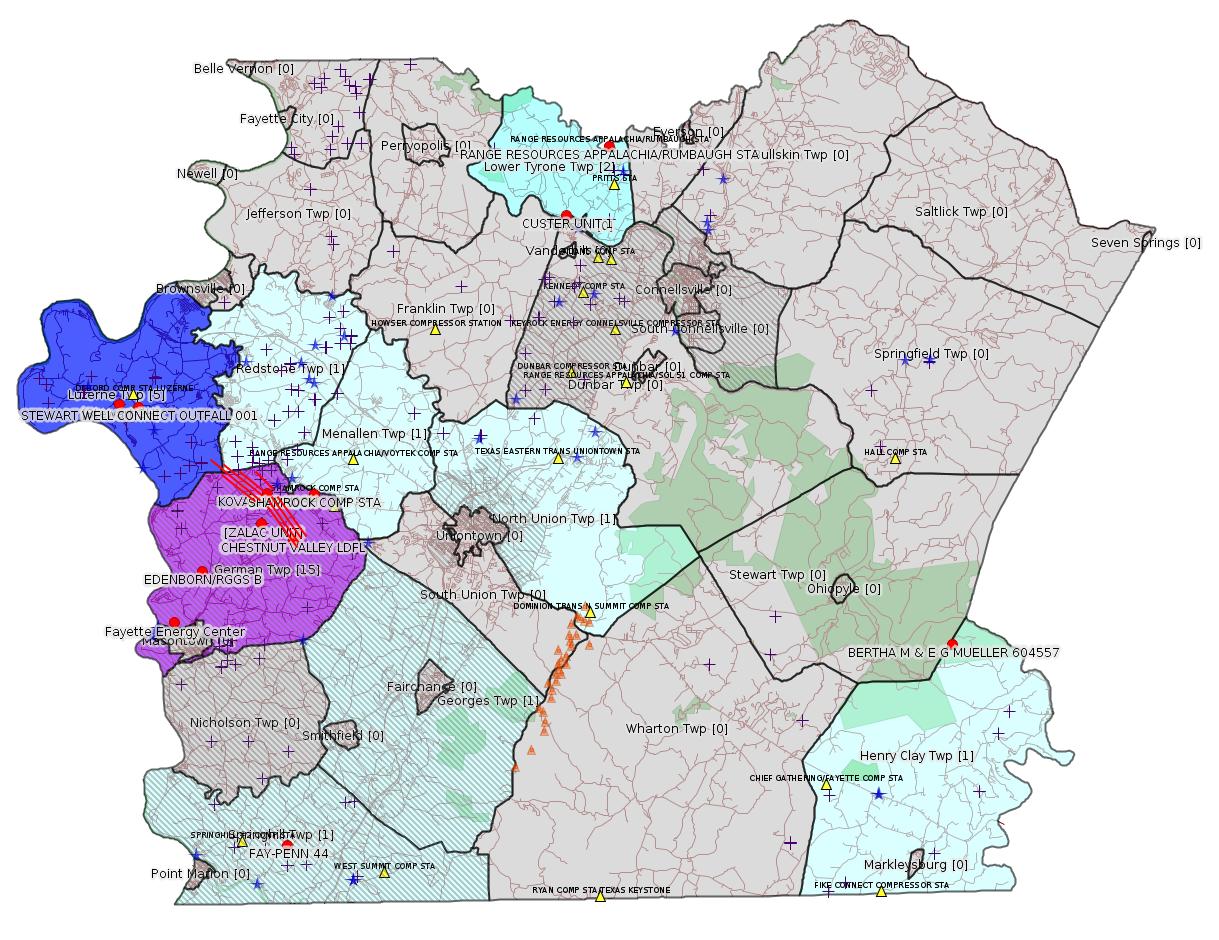
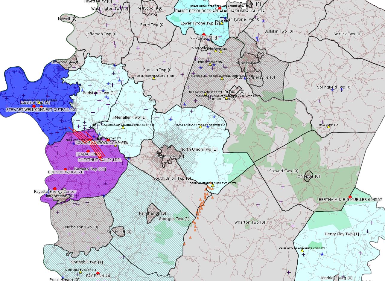
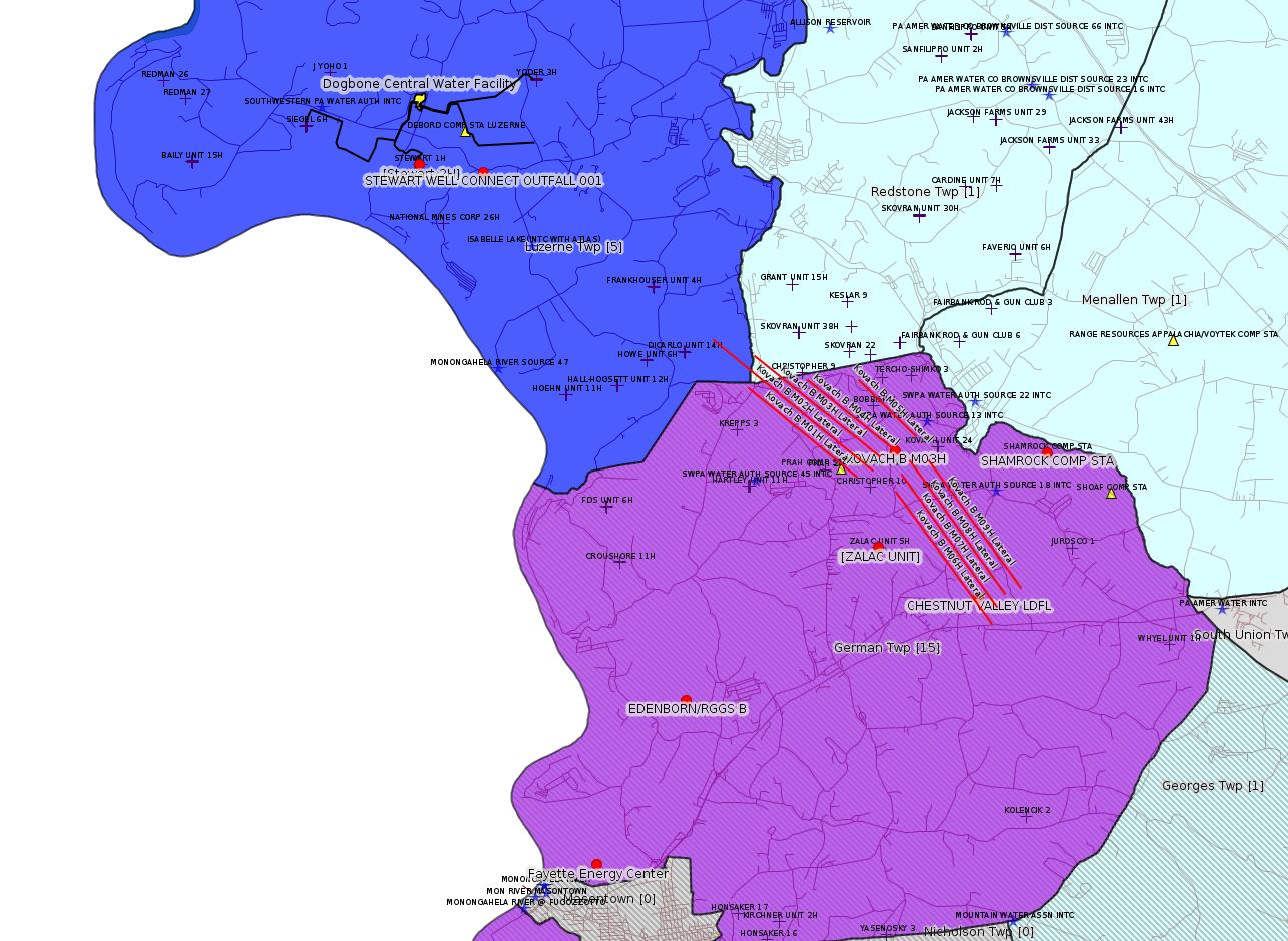
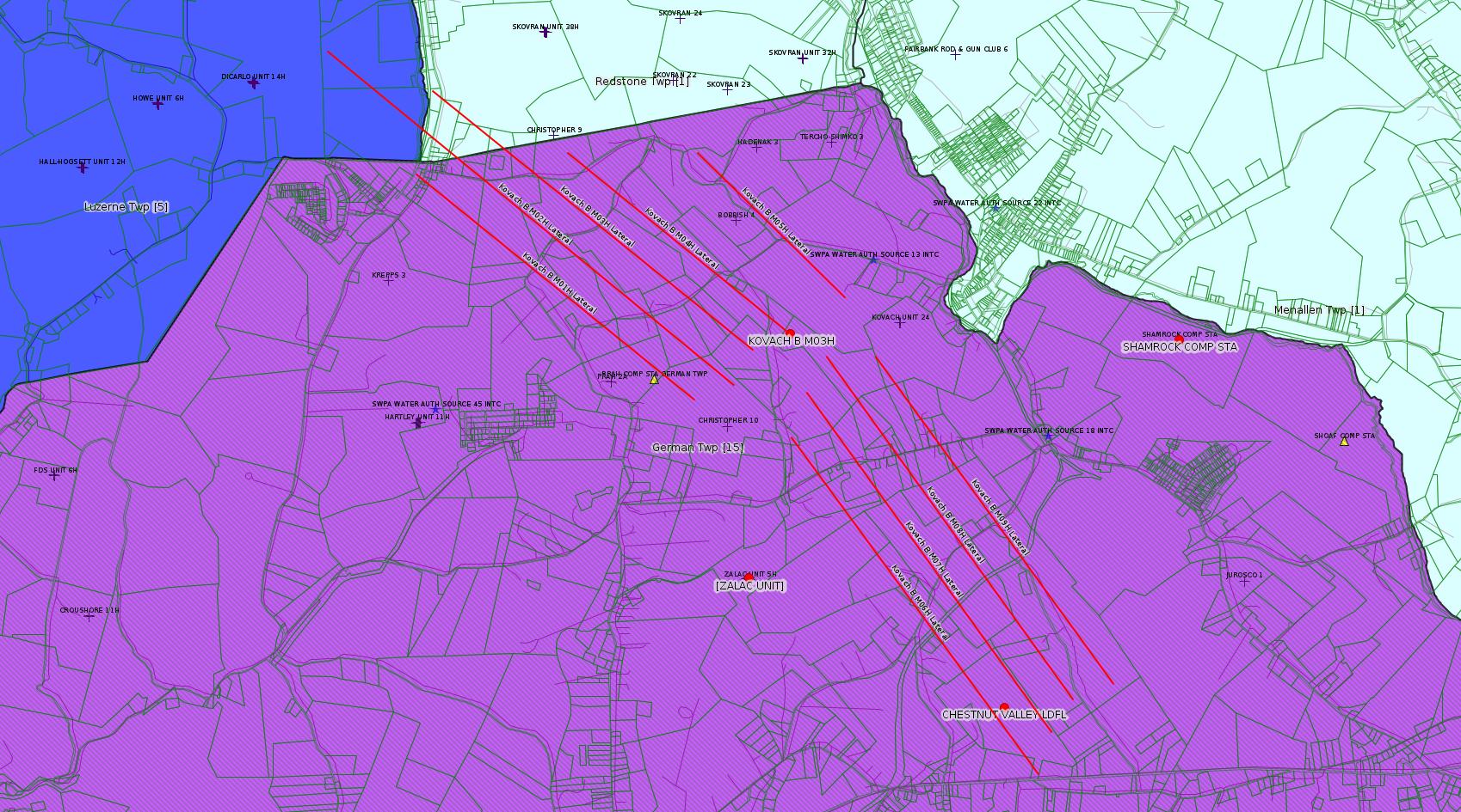
Map
Key
Red dots: items in this permit list with an exact location.
Blue stars: Marcellus Gas Well Water Sources.
Municipality shading: number of "facilities", with each well counting separately
(includes the red dots):
Red dots: items in this permit list with an exact location.
Blue stars: Marcellus Gas Well Water Sources.
Municipality shading: number of "facilities", with each well counting separately
(includes the red dots):
gray: 0
pale turquoise: 1
turquoise: 2
pale blue: 3
middle blue: 4
dark blue: 5
dark purple: 9
purple: 15
(Color coding may differ from one issue to the next.)
(Note if a project spans multiple municipalities -- e.g. a pipeline -- it will show in the count for each municipality.)
The number of facilities also follows the municipality name in brackets.
Municipality counts are based on the way the permit is listed by DEP; DEP has been known to get a municipality wrong.
Locations in brackets identify a precise location used to locate a surrogate for the actual site being permitted (e.g. locating a well pad or pipeline by the known location of a well.) Locations labeled beginning with "~" and ending in "[?]" are approximate and speculative based on inferences using on-line property and lease records. These are marked in the text as "[Approximate, Speculative]
Cross-hatching: Environmental Justice Areas
Yellow triangles: Compressor Stations
Orange triangles: Storage Field Wells (currently Dominion North Summit Storage Field)
Crosses: SPUD Unconventional well permits
Green: "Natural areas", e.g. state game lands, state forests
Yellow triangles: Compressor Stations
Orange triangles: Storage Field Wells (currently Dominion North Summit Storage Field)
Crosses: SPUD Unconventional well permits
Green: "Natural areas", e.g. state game lands, state forests
More Maps
 |
 |
 |
 |
Source: Pennsylvania Bulletin
NOTICES
GOVERNOR'S OFFICE
Regulatory Agenda
[48 Pa.B. 4729]
[Saturday, August 4, 2018]
Executive Order 1996-1 requires all agencies under the jurisdiction of the Governor to submit for publication semi-annually an agenda of regulations under development or consideration.
The agendas are compiled to provide members of the regulated community advanced notice of regulatory activity. It is the intention of the Administration that these agendas will serve to increase public participation in the regulatory process.
Agency contacts should be contacted for more information regarding the regulation and the procedure for submitting comments.
This Agenda represents the Administration's present intentions regarding future regulations. The information provided is current as of July 13, 2018. The nature and complexity of an individual regulation obviously will determine whether and when any particular regulation listed (as well as any considered subsequent to publication of this Agenda) is published.
[Excerpts:]
| Regulation Being Considered | Proposed Date of Promulgation |
Need and Legal Basis for Action |
Agency Contact |
| Unconventional Well Permit Application Fees 25 Pa. Code Chapter 78a (# 7-542) |
Quarter 3, 2018, Publication, as Proposed | This rulemaking proposes amendments to 25 Pa. Code §§ 78a.1 (relating to definitions and 78a.19 (relating to permit application fee schedule). These amendments are necessary to increase fees to support the administration of 58 Pa.C.S. Chapter 32 (related to development) (2012 Oil and Gas Act) by the DEP's Office of Oil and Gas Management. The proposed rulemaking increases the current well permit application fees from $5,000 for nonvertical unconventional wells and $4,200 for vertical unconventional wells, to $12,500 for all unconventional well permit applications to administer the 2012 Oil and Gas Act. (2012 Oil and Gas Act) | Kurt Klapkowski (717) 772-2199 kklapkowsk@pa.gov |
| Environmental Protection Performance
Standards for Conventional Oil and Gas Operators 25 Pa. Code Chapter 78 (# 7-539) |
Quarter 1, 2019, EQB Consideration, as Proposed | This rulemaking proposes to amend the Oil and Gas regulations applicable to conventional operators (Chapter 78) to update the environmental protection performance standards related to oil and gas activities. (2012 Oil and Gas Act, Clean Streams Law, Solid Waste Management Act, Dam Safety Encroachment Act, Land Recycling and Environmental Remediation Standards Act, Radiation Protection Act, Unconventional Well Report Act, Act 126 of 2014) | Kurt Klapkowski (717) 772-2199 kklapkowsk@pa.gov |
| Air Quality Fee Schedule Amendments 25 Pa. Code Chapters 127 and 139 (# 7-536) |
Quarter 4, 2018, EQB Consideration, as Proposed | This rulemaking proposes to revise existing requirements and fee schedules codified in Chapter 127, Subchapter I to ensure that fees collected are sufficient to cover the costs of administering the air program as required under Section 6.3(a) of the Air Pollution Control Act (35 P.S. § 4006.3(a)). Upon promulgation, the final-form regulation will be submitted to the EPA for approval as a revision to the SIP or the Title V Program Approval, as appropriate. (Air Pollution Control Act) | Susan Hoyle (717) 772-2329 shoyle@pa.gov |
| Control of Emissions from the Oil and Natural
Gas Industry 25 Pa. Code Chapter 129 (# 7-544) |
Quarter 1, 2019, EQB Consideration, as Proposed | This rulemaking proposes to establish emission limitations and other requirements codified in 25 Pa. Code Chapter 129 consistent with reasonably available control technology (RACT). The proposed rulemaking would establish RACT requirements for volatile organic compounds and other pollutants from existing oil and natural gas production facilities, compressor stations, processing plants, and transmission stations. (Air Pollution Control Act) | Susan Hoyle (717) 772-2329 shoyle@pa.gov |
| Electronic Submission of Air Quality General
Plan Approval and General Operating Permit Applications 25 Pa. Code Chapter 127 (# 7-549) |
Quarter 3, 2018, EQB Consideration, as Final-Omitted | This final-omitted rulemaking amends 25 Pa. Code § 127.621(b) (relating to application for use of general plan approvals and general operating permits) to add the option of electronic means as authorized by the Department for delivery of applications for air quality general plan approvals (GPA) and general operating permits (GP). (Clean Air Act, Air Pollution Control Act) | Susan Hoyle (717) 772-2329 shoyle@pa.gov |
| Additional Requirements for Control of Fine
Particulate Matter in the Nonattainment New Source Review
Program 25 Pa. Code Chapters 121 and 127 (# 7-551) |
Quarter 4, 2018, EQB Consideration, as Proposed | This proposed rulemaking would amend Chapter 127, Subchapter E to incorporate Federal requirements issued by the EPA on August 26, 2016, for the regulation of precursor emissions to the formation of particulate matter less than and equal to 2.5 micrometers in diameter (PM2.5). The EPA's final rule requires states with nonattainment areas for PM2.5 to amend their new source review (NSR) regulations to include emissions of volatile organic compounds (VOC) and ammonia as PM2.5 precursors. See 81 FR 58010. The proposed amendments would limit the emissions of VOC and ammonia as PM2.5 precursors for new major sources or major sources being modified in certain counties of this Commonwealth that are designated as nonattainment for the PM2.5 National Ambient Air Quality Standard. This proposed rulemaking would also add PM2.5 significant impact levels (SIL) to conform with the EPA guidance for SILs published on April 17, 2018. (Air Pollution Control Act) | Susan Hoyle (717) 772-2329 shoyle@pa.gov |
<https://www.pabulletin.com/secure/data/vol48/48-31/1212.html>
[For the full Regulatory Agenda, see the link above.]
---
GP5-26-00483A (AG5-26-00001A): Range Resources- Appalachia LLC (3000 Town Center Blvd., Canonsburg, PA 15317) on July 19, 2018, to operate previously installed—one (1) natural gas fired Caterpillar compressor engine, Model G3516 LE-4EK03170, 4SLB, rated at 1,340 bhp at 1,400 rpm, equipped with an air fuel ratio controller, no add-on control installed on this unit; one (1) Natco, TEG dehydrator, Model SB12-6, rated at 5.0 MMscfd, and attached to a reboiler rated at 0.25 MMBtu/hr; and four (4) Storage pipeline fluid tanks, each with a capacity of 2,100 gallons. The estimated annual throughput of each of four tanks is 2,100 gallons at their Rumbaugh Compressor Station located in Lower Tyrone Township, Fayette County.
<https://www.pabulletin.com/secure/data/vol48/48-31/1201d.html>
Primary Facility ID: 562423
Location: 40.084655,-79.636567 <https://osm.org/go/ZWsirJaI--?m=>
Presumed Parcel Id: 18050023
-------------------------
Source: eNOTICE (+ PA Oil and Gas Mapping, Well Pad Report.) Well Details via Data Portal Services: Oil and Gas Wells All (ID: 3).
Please see the Disclaimer below regarding Parcel Id data.
New:
Authorization ID: 1238739
Permit number: ESX15-051-0010
Site: ZALAC WELL CONNECT ESCGP-2 EXPEDITED
Client: LAUREL MTN MIDSTREAM OPR LLC
Authorization type: Expedited E&S Stormwater General Permit 1
Application type: Notification
Authorization is for: SITE
Date received: 08/02/2018
Status: Pending
Permit Decision Guarantee Applies?: No
Permit Review Notes:
Date Review Note
8/3/2018 The permit application package is complete, has been accepted, and is undergoing technical review.
<https://www.ahs.dep.pa.gov/eFACTSWeb/searchResults_singleAuth.aspx?AuthID=1238739>
Site Programs:
Site Municipalities:
German Twp [an Environmental Justice Area], Fayette County
Locatiion [of ZALAC UNIT Well Pad]: 39.904611,-79.858172 <https://osm.org/go/ZWpaKHEP--?m=>
Presumed Parcel Id: 15110064
New:
Authorization ID: 1238521
Permit number: 26-00588
Site: SHAMROCK COMP STA
Client: LAUREL MTN MIDSTREAM OPR LLC
Authorization type: Minor Facility Plan Approval New Source Performance Std
Application type: Extension
Authorization is for: FACILITY
Date received: 07/26/2018
Status: Pending
Permit Decision Guarantee Applies?: No
<https://www.ahs.dep.pa.gov/eFACTSWeb/searchResults_singleAuth.aspx?AuthID=1238521>
Site Programs:
Air Quality
Site Municipalities:
German Twp [an Environmental Justice Area], Fayette County
Location: 39.918333,-79.825 <http://osm.org/go/ZWpasXGm--?m=>
Parcel ID: 15140026
New:
Authorization ID: 1238515
Permit number: 26-00588A
Site: SHAMROCK COMP STA
Client: LAUREL MTN MIDSTREAM OPR LLC
Authorization type: Major Facility Plan Approval New Facility Review Prevention of Significant Deterioration
Application type: Extension
Authorization is for: FACILITY
Date received: 07/26/2018
Status: Pending
Permit Decision Guarantee Applies?: No
<https://www.ahs.dep.pa.gov/eFACTSWeb/searchResults_singleAuth.aspx?AuthID=1238515>
Site Programs:
Air Quality
Site Municipalities:
German Twp [an Environmental Justice Area], Fayette County
New:
[Arguably Off-Topic:]
Authorization ID: 1238510
Permit number: 26-00535B
Site: FAYETTE ENERGY FACILITY
Client: DYNEGY FAYETTE II, LLC
Authorization type: Major Facility Plan Approval New Source Performance Std
Application type: Extension
Authorization is for: FACILITY
Date received: 07/24/2018
Status: Pending
Permit Decision Guarantee Applies?: No
<https://www.ahs.dep.pa.gov/eFACTSWeb/searchResults_singleAuth.aspx?AuthID=1238510>
Site Programs:
Air Quality
Waste Management
Water Planning and Conservation
Site Municipalities:
German Twp [an Environmental Justice Area], Fayette County
Masontown Boro [Incorrect -jr], Fayette County
Location: 39.857412,-79.913878 <http://osm.org/go/ZWpM9Ua6--?m=>
Presumed Parcel Id: 1530006703
New:
Authorization ID: 1238328
Permit number: GP112618214
Site: TEXAS EASTERN TRANSMISSION FAYETTE CNTY
Client: TEXAS EASTERN TRANS LP
Authorization type: BWM-GP-11 Maintenance, Testing, Repair, Rehabilitation or Replacement General Pmt
Application type: New
Authorization is for: FACILITY
Date received: 07/26/2018
Status: Issued on 8/2/2018
Permit Decision Guarantee Applies?: Yes
Permit Decision Guarantee status: VOID
Permit Review Notes:
Date Review Note
8/2/2018 The technical review and decision review are complete and either the permit decision and/or permit issuance are forthcoming.
8/1/2018 Applicant has been issued a deficiency letter. If applicable, this application no longer qualifies for the Permit Decision Guarantee.
8/1/2018 The permit application package is complete, has been accepted, and is undergoing technical review.
<https://www.ahs.dep.pa.gov/eFACTSWeb/searchResults_singleAuth.aspx?AuthID=1238328>
Site Programs:
Water Planning and Conservation
Site Municipalities:
German Twp, Fayette County
Menallen Twp, Fayette County
North Union Twp, Fayette County
New:
Authorization ID: 1238283
Permit number: PAG106213
Site: STEWART WELL CONNECT
Client: LAUREL MTN MIDSTREAM OPR LLC
Authorization type: PAG-10 Discharge Resulting from Hydrostatic Testing of Tanks & Pipelines
Application type: New
Authorization is for: FACILITY
Date received: 07/24/2018
Status: Pending
Permit Decision Guarantee Applies?: Yes
Permit Decision Guarantee status: ACTIVE
Sub-Facilities for Authorization:
Sub-Facility ID Sub-Facility Name Description
1263409 OUTFALL 001 Discharge Point
Location: 39.961653,-79.934522
Map URL: <http://www.openstreetmap.org/?mlat=39.961653&mlon=-79.934522#map=15/39.961653/-79.934522>
Permit Review Notes:
Date Review Note
8/8/2018 The permit application package is complete, has been accepted, and is undergoing technical review.
<https://www.ahs.dep.pa.gov/eFACTSWeb/searchResults_singleAuth.aspx?AuthID=1238283>
Site Programs:
Clean Water
Site Municipalities:
Luzerne Twp, Fayette County
Presumed Parcel Id: 19250012
New:
Authorization ID: 1237730
Permit number: 051-24674
Site: KOVACH B WELL SITE AND TANK SITE ESCGP ESX17-051-0003
Client: CHEVRON APPALACHIA LLC
Authorization type: Drill & Operate Well Permit (Unconventional)
Application type: New
Authorization is for: FACILITY
Date received: 07/26/2018
Status: Issued on 8/8/2018
Permit Decision Guarantee Applies?: No
Sub-Facilities for Authorization:
Sub-Facility ID Sub-Facility Name Description
1263132 WELLBORE SURFACE HOLE LOCATION Well
Permit Review Notes:
Date Review Note
8/7/2018 The technical review and decision review are complete and either the permit decision and/or permit issuance are forthcoming.
7/26/2018 The permit application package is complete, has been accepted, and is undergoing technical review.
<https://www.ahs.dep.pa.gov/eFACTSWeb/searchResults_singleAuth.aspx?AuthID=1237730>
Site Programs:
Oil & Gas
Site Municipalities:
German Twp, Fayette County
Well Details:
Permit Number: 051-24674
Well Name: KOVACH B M03H
Unconventional Well: Y
Well Configuration: Horizontal Well
Well Type: GAS
Well Status: Active
Coal Association: Coal
Conservation Well: N
Primary Facility ID: 828040
Site ID: 826949
Site Name: KOVACH B WELL SITE AND TANK SITE ESCGP ESX17-051-0003
Well Pad ID: 155005
Well Pad Name: KOVACH B
Storage Field:
Operator: CHEVRON APPALACHIA LLC
Operator Number: OGO-39307
Permit Date: 2018-08-08
Permit Date Expires: 2019-08-08
SPUD Date:
Date Plugged:
UIC ID:
UIC Type:
Surface Elevation: 1278
County: Fayette
Municipality: German Twp
Location: 39.919008,-79.854764
Map URL: <http://www.openstreetmap.org/?mlat=39.919008&mlon=-79.854764#map=15/39.919008/-79.854764>
OG WELLS PERMIT DOCS:
2018-08-08: Final Permit Documents, Name: 1237730 (for Authorization: 1237730):
<http://www.depgis.state.pa.us/pdfHandler/pdFHandler.ashx?Doc=NjQ2Nzgz&ext=PDF>
Electronically Submitted Records:
2018-08-08: Submission for Authorization 1237730
Interested Party Notification: Kovach B Affidavit of Non-Delivery Venere.pdf
<http://www.depgis.state.pa.us/eWellDocHandler/pdFHandler.ashx?Doc=NjAxOTgy&ext=PDF>
Pennsylvania Natural Diversity Inventory Form: Kovach B PNDI.pdf
<http://www.depgis.state.pa.us/eWellDocHandler/pdFHandler.ashx?Doc=NjAyMDAy&ext=PDF>
Location Plat: Kovach B M03H Plat.dwg
<http://www.depgis.state.pa.us/eWellDocHandler/pdFHandler.ashx?Doc=NjAyMDAz&ext=PDF>
Coal and Gas Resource Coord Act - Section 7 Exception: Kovach B Horizontals Section 7 Exception.pdf
<http://www.depgis.state.pa.us/eWellDocHandler/pdFHandler.ashx?Doc=NjAyMDA0&ext=PDF>
Well Cross-Section Diagram: Kovach B M03H Page 4.pdf
<http://www.depgis.state.pa.us/eWellDocHandler/pdFHandler.ashx?Doc=NjAyMDA1&ext=PDF>
Permit Application to Drill and Operate a Well: 1753252.pdf
<http://www.depgis.state.pa.us/eWellDocHandler/pdFHandler.ashx?Doc=NjAzODM4&ext=PDF>
New:
Authorization ID: 1237729
Permit number: 051-24673
Site: KOVACH B WELL SITE AND TANK SITE ESCGP ESX17-051-0003
Client: CHEVRON APPALACHIA LLC
Authorization type: Drill & Operate Well Permit (Unconventional)
Application type: New
Authorization is for: FACILITY
Date received: 07/26/2018
Status: Issued on 8/8/2018
Permit Decision Guarantee Applies?: No
Sub-Facilities for Authorization:
Sub-Facility ID Sub-Facility Name Description
1263131 WELLBORE SURFACE HOLE LOCATION Well
Permit Review Notes:
Date Review Note
8/7/2018 The technical review and decision review are complete and either the permit decision and/or permit issuance are forthcoming.
7/26/2018 The permit application package is complete, has been accepted, and is undergoing technical review.
<https://www.ahs.dep.pa.gov/eFACTSWeb/searchResults_singleAuth.aspx?AuthID=1237729>
Site Programs:
Oil & Gas
Site Municipalities:
German Twp, Fayette County
Well Details:
Permit Number: 051-24673
Well Name: KOVACH B M06H
Unconventional Well: Y
Well Configuration: Horizontal Well
Well Type: GAS
Well Status: Active
Coal Association: Coal
Conservation Well: N
Primary Facility ID: 828039
Site ID: 826949
Site Name: KOVACH B WELL SITE AND TANK SITE ESCGP ESX17-051-0003
Well Pad ID: 155005
Well Pad Name: KOVACH B
Storage Field:
Operator: CHEVRON APPALACHIA LLC
Operator Number: OGO-39307
Permit Date: 2018-08-08
Permit Date Expires: 2019-08-08
SPUD Date:
Date Plugged:
UIC ID:
UIC Type:
Surface Elevation: 1278
County: Fayette
Municipality: German Twp
Location: 39.919122,-79.8547
Map URL: <http://www.openstreetmap.org/?mlat=39.919122&mlon=-79.8547#map=15/39.919122/-79.8547>
OG WELLS PERMIT DOCS:
2018-08-08: Final Permit Documents, Name: 1237729 (for Authorization: 1237729):
<http://www.depgis.state.pa.us/pdfHandler/pdFHandler.ashx?Doc=NjQ2Nzgx&ext=PDF>
Electronically Submitted Records:
2018-08-08: Submission for Authorization 1237729
Interested Party Notification: Kovach B Affidavit of Non-Delivery Venere.pdf
<http://www.depgis.state.pa.us/eWellDocHandler/pdFHandler.ashx?Doc=NjAyNTE3&ext=PDF>
Pennsylvania Natural Diversity Inventory Form: Kovach B PNDI.pdf
<http://www.depgis.state.pa.us/eWellDocHandler/pdFHandler.ashx?Doc=NjAyNTI1&ext=PDF>
Location Plat: Kovach B M06H Plat.dwg
<http://www.depgis.state.pa.us/eWellDocHandler/pdFHandler.ashx?Doc=NjAyNTI2&ext=PDF>
Coal and Gas Resource Coord Act - Section 7 Exception: Kovach B Horizontals Section 7 Exception.pdf
<http://www.depgis.state.pa.us/eWellDocHandler/pdFHandler.ashx?Doc=NjAyNTI3&ext=PDF>
Well Cross-Section Diagram: Kovach B M06H Page 4.pdf
<http://www.depgis.state.pa.us/eWellDocHandler/pdFHandler.ashx?Doc=NjAyNTI4&ext=PDF>
Permit Application to Drill and Operate a Well: 1753541.pdf
<http://www.depgis.state.pa.us/eWellDocHandler/pdFHandler.ashx?Doc=NjAzODY5&ext=PDF>
New:
Authorization ID: 1237728
Permit number: 051-24672
Site: KOVACH B WELL SITE AND TANK SITE ESCGP ESX17-051-0003
Client: CHEVRON APPALACHIA LLC
Authorization type: Drill & Operate Well Permit (Unconventional)
Application type: New
Authorization is for: FACILITY
Date received: 07/26/2018
Status: Issued on 8/8/2018
Permit Decision Guarantee Applies?: No
Sub-Facilities for Authorization:
Sub-Facility ID Sub-Facility Name Description
1263130 WELLBORE SURFACE HOLE LOCATION Well
Permit Review Notes:
Date Review Note
8/7/2018 The technical review and decision review are complete and either the permit decision and/or permit issuance are forthcoming.
7/26/2018 The permit application package is complete, has been accepted, and is undergoing technical review.
<https://www.ahs.dep.pa.gov/eFACTSWeb/searchResults_singleAuth.aspx?AuthID=1237728>
Site Programs:
Oil & Gas
Site Municipalities:
German Twp, Fayette County
Well Details:
Permit Number: 051-24672
Well Name: KOVACH B M02H
Unconventional Well: Y
Well Configuration: Horizontal Well
Well Type: GAS
Well Status: Active
Coal Association: Coal
Conservation Well: N
Primary Facility ID: 828038
Site ID: 826949
Site Name: KOVACH B WELL SITE AND TANK SITE ESCGP ESX17-051-0003
Well Pad ID: 155005
Well Pad Name: KOVACH B
Storage Field:
Operator: CHEVRON APPALACHIA LLC
Operator Number: OGO-39307
Permit Date: 2018-08-08
Permit Date Expires: 2019-08-08
SPUD Date:
Date Plugged:
UIC ID:
UIC Type:
Surface Elevation: 1278
County: Fayette
Municipality: German Twp
Location: 39.918972,-79.854786
Map URL: <http://www.openstreetmap.org/?mlat=39.918972&mlon=-79.854786#map=15/39.918972/-79.854786>
OG WELLS PERMIT DOCS:
2018-08-08: Final Permit Documents, Name: 1237728 (for Authorization: 1237728):
<http://www.depgis.state.pa.us/pdfHandler/pdFHandler.ashx?Doc=NjQ2Nzc4&ext=PDF>
Electronically Submitted Records:
2018-08-08: Submission for Authorization 1237728
Interested Party Notification: Kovach B Affidavit of Non-Delivery Venere.pdf
<http://www.depgis.state.pa.us/eWellDocHandler/pdFHandler.ashx?Doc=NjAxODc1&ext=PDF>
Pennsylvania Natural Diversity Inventory Form: Kovach B PNDI.pdf
<http://www.depgis.state.pa.us/eWellDocHandler/pdFHandler.ashx?Doc=NjAxODc5&ext=PDF>
Location Plat: Kovach B M02H Plat.dwg
<http://www.depgis.state.pa.us/eWellDocHandler/pdFHandler.ashx?Doc=NjAxODgw&ext=PDF>
Well Cross-Section Diagram: Kovach B M02H Page 4.pdf
<http://www.depgis.state.pa.us/eWellDocHandler/pdFHandler.ashx?Doc=NjAxODgy&ext=PDF>
Coal and Gas Resource Coord Act - Section 7 Exception: Kovach B Horizontals Section 7 Exception.pdf
<http://www.depgis.state.pa.us/eWellDocHandler/pdFHandler.ashx?Doc=NjAxODkz&ext=PDF>
Permit Application to Drill and Operate a Well: 1753234.pdf
<http://www.depgis.state.pa.us/eWellDocHandler/pdFHandler.ashx?Doc=NjAzODI3&ext=PDF>
New:
Authorization ID: 1237727
Permit number: 051-24671
Site: KOVACH B WELL SITE AND TANK SITE ESCGP ESX17-051-0003
Client: CHEVRON APPALACHIA LLC
Authorization type: Drill & Operate Well Permit (Unconventional)
Application type: New
Authorization is for: FACILITY
Date received: 07/26/2018
Status: Issued on 8/8/2018
Permit Decision Guarantee Applies?: No
Sub-Facilities for Authorization:
Sub-Facility ID Sub-Facility Name Description
1263129 WELLBORE SURFACE HOLE LOCATION Well
Permit Review Notes:
Date Review Note
8/7/2018 The technical review and decision review are complete and either the permit decision and/or permit issuance are forthcoming.
7/26/2018 The permit application package is complete, has been accepted, and is undergoing technical review.
<https://www.ahs.dep.pa.gov/eFACTSWeb/searchResults_singleAuth.aspx?AuthID=1237727>
Site Programs:
Oil & Gas
Site Municipalities:
German Twp, Fayette County
Well Details:
Permit Number: 051-24671
Well Name: KOVACH B M01H
Unconventional Well: Y
Well Configuration: Horizontal Well
Well Type: GAS
Well Status: Active
Coal Association: Coal
Conservation Well: N
Primary Facility ID: 828037
Site ID: 826949
Site Name: KOVACH B WELL SITE AND TANK SITE ESCGP ESX17-051-0003
Well Pad ID: 155005
Well Pad Name: KOVACH B
Storage Field:
Operator: CHEVRON APPALACHIA LLC
Operator Number: OGO-39307
Permit Date: 2018-08-08
Permit Date Expires: 2019-08-08
SPUD Date:
Date Plugged:
UIC ID:
UIC Type:
Surface Elevation: 1278
County: Fayette
Municipality: German Twp
Location: 39.918933,-79.854808
Map URL: <http://www.openstreetmap.org/?mlat=39.918933&mlon=-79.854808#map=15/39.918933/-79.854808>
OG WELLS PERMIT DOCS:
2018-08-08: Final Permit Documents, Name: 1237727 (for Authorization: 1237727):
<http://www.depgis.state.pa.us/pdfHandler/pdFHandler.ashx?Doc=NjQ2Nzc2&ext=PDF>
Electronically Submitted Records:
2018-08-08: Submission for Authorization 1237727
Pennsylvania Natural Diversity Inventory Form: Kovach B PNDI.pdf
<http://www.depgis.state.pa.us/eWellDocHandler/pdFHandler.ashx?Doc=NjAxNjky&ext=PDF>
Coal and Gas Resource Coord Act - Section 7 Exception: Kovach B Horizontals Section 7 Exception.pdf
<http://www.depgis.state.pa.us/eWellDocHandler/pdFHandler.ashx?Doc=NjAxNjkz&ext=PDF>
Well Cross-Section Diagram: Kovach B M01H Page 4.pdf
<http://www.depgis.state.pa.us/eWellDocHandler/pdFHandler.ashx?Doc=NjAxODA2&ext=PDF>
Interested Party Notification: Kovach B Affidavit of Non-Delivery Venere.pdf
<http://www.depgis.state.pa.us/eWellDocHandler/pdFHandler.ashx?Doc=NjAxODE4&ext=PDF>
Location Plat: Kovach B M01H Plat.dwg
<http://www.depgis.state.pa.us/eWellDocHandler/pdFHandler.ashx?Doc=NjAxODI5&ext=PDF>
Permit Application to Drill and Operate a Well: 1747807.pdf
<http://www.depgis.state.pa.us/eWellDocHandler/pdFHandler.ashx?Doc=NjAzODE3&ext=PDF>
New:
Authorization ID: 1237726
Permit number: 051-24670
Site: KOVACH B WELL SITE AND TANK SITE ESCGP ESX17-051-0003
Client: CHEVRON APPALACHIA LLC
Authorization type: Drill & Operate Well Permit (Unconventional)
Application type: New
Authorization is for: FACILITY
Date received: 07/26/2018
Status: Issued on 8/8/2018
Permit Decision Guarantee Applies?: No
Sub-Facilities for Authorization:
Sub-Facility ID Sub-Facility Name Description
1263128 WELLBORE SURFACE HOLE LOCATION Well
Permit Review Notes:
Date Review Note
8/7/2018 The technical review and decision review are complete and either the permit decision and/or permit issuance are forthcoming.
7/26/2018 The permit application package is complete, has been accepted, and is undergoing technical review.
<https://www.ahs.dep.pa.gov/eFACTSWeb/searchResults_singleAuth.aspx?AuthID=1237726>
Site Programs:
Oil & Gas
Site Municipalities:
German Twp, Fayette County
Well Details:
Permit Number: 051-24670
Well Name: KOVACH B M09H
Unconventional Well: Y
Well Configuration: Horizontal Well
Well Type: GAS
Well Status: Active
Coal Association: Coal
Conservation Well: N
Primary Facility ID: 828036
Site ID: 826949
Site Name: KOVACH B WELL SITE AND TANK SITE ESCGP ESX17-051-0003
Well Pad ID: 155005
Well Pad Name: KOVACH B
Storage Field:
Operator: CHEVRON APPALACHIA LLC
Operator Number: OGO-39307
Permit Date: 2018-08-08
Permit Date Expires: 2019-08-08
SPUD Date:
Date Plugged:
UIC ID:
UIC Type:
Surface Elevation: 1278
County: Fayette
Municipality: German Twp
Location: 39.919231,-79.854758
Map URL: <http://www.openstreetmap.org/?mlat=39.919231&mlon=-79.854758#map=15/39.919231/-79.854758>
OG WELLS PERMIT DOCS:
2018-08-08: Final Permit Documents, Name: 1237726 (for Authorization: 1237726):
<http://www.depgis.state.pa.us/pdfHandler/pdFHandler.ashx?Doc=NjQ2Nzc1&ext=PDF>
Electronically Submitted Records:
2018-08-08: Submission for Authorization 1237726
Interested Party Notification: Kovach B Affidavit of Non-Delivery Venere.pdf
<http://www.depgis.state.pa.us/eWellDocHandler/pdFHandler.ashx?Doc=NjAyNjM1&ext=PDF>
Coal and Gas Resource Coord Act - Section 7 Exception: Kovach B Horizontals Section 7 Exception.pdf
<http://www.depgis.state.pa.us/eWellDocHandler/pdFHandler.ashx?Doc=NjAyNjQw&ext=PDF>
Pennsylvania Natural Diversity Inventory Form: Kovach B PNDI.pdf
<http://www.depgis.state.pa.us/eWellDocHandler/pdFHandler.ashx?Doc=NjAyNjQx&ext=PDF>
Location Plat: Kovach B M09H Plat.dwg
<http://www.depgis.state.pa.us/eWellDocHandler/pdFHandler.ashx?Doc=NjAyNjQy&ext=PDF>
Well Cross-Section Diagram: Kovach B M09H Page 4.pdf
<http://www.depgis.state.pa.us/eWellDocHandler/pdFHandler.ashx?Doc=NjAyNjQz&ext=PDF>
Permit Application to Drill and Operate a Well: 1753557.pdf
<http://www.depgis.state.pa.us/eWellDocHandler/pdFHandler.ashx?Doc=NjAzODg3&ext=PDF>
New:
Authorization ID: 1237725
Permit number: 051-24669
Site: KOVACH B WELL SITE AND TANK SITE ESCGP ESX17-051-0003
Client: CHEVRON APPALACHIA LLC
Authorization type: Drill & Operate Well Permit (Unconventional)
Application type: New
Authorization is for: FACILITY
Date received: 07/26/2018
Status: Issued on 8/8/2018
Permit Decision Guarantee Applies?: No
Sub-Facilities for Authorization:
Sub-Facility ID Sub-Facility Name Description
1263127 WELLBORE SURFACE HOLE LOCATION Well
Permit Review Notes:
Date Review Note
8/7/2018 The technical review and decision review are complete and either the permit decision and/or permit issuance are forthcoming.
7/26/2018 The permit application package is complete, has been accepted, and is undergoing technical review.
<https://www.ahs.dep.pa.gov/eFACTSWeb/searchResults_singleAuth.aspx?AuthID=1237725>
Site Programs:
Oil & Gas
Site Municipalities:
German Twp, Fayette County
Well Details:
Permit Number: 051-24669
Well Name: KOVACH B M08H
Unconventional Well: Y
Well Configuration: Horizontal Well
Well Type: GAS
Well Status: Active
Coal Association: Coal
Conservation Well: N
Primary Facility ID: 828035
Site ID: 826949
Site Name: KOVACH B WELL SITE AND TANK SITE ESCGP ESX17-051-0003
Well Pad ID: 155005
Well Pad Name: KOVACH B
Storage Field:
Operator: CHEVRON APPALACHIA LLC
Operator Number: OGO-39307
Permit Date: 2018-08-08
Permit Date Expires: 2019-08-08
SPUD Date:
Date Plugged:
UIC ID:
UIC Type:
Surface Elevation: 1278
County: Fayette
Municipality: German Twp
Location: 39.919197,-79.854658
Map URL: <http://www.openstreetmap.org/?mlat=39.919197&mlon=-79.854658#map=15/39.919197/-79.854658>
OG WELLS PERMIT DOCS:
2018-08-08: Final Permit Documents, Name: 1237725 (for Authorization: 1237725):
<http://www.depgis.state.pa.us/pdfHandler/pdFHandler.ashx?Doc=NjQ2Nzc0&ext=PDF>
Electronically Submitted Records:
2018-08-08: Submission for Authorization 1237725
Interested Party Notification: Kovach B Affidavit of Non-Delivery Venere.pdf
<http://www.depgis.state.pa.us/eWellDocHandler/pdFHandler.ashx?Doc=NjAyNjA5&ext=PDF>
Coal and Gas Resource Coord Act - Section 7 Exception: Kovach B Horizontals Section 7 Exception.pdf
<http://www.depgis.state.pa.us/eWellDocHandler/pdFHandler.ashx?Doc=NjAyNjE1&ext=PDF>
Pennsylvania Natural Diversity Inventory Form: Kovach B PNDI.pdf
<http://www.depgis.state.pa.us/eWellDocHandler/pdFHandler.ashx?Doc=NjAyNjE2&ext=PDF>
Location Plat: Kovach B M08H Plat.dwg
<http://www.depgis.state.pa.us/eWellDocHandler/pdFHandler.ashx?Doc=NjAyNjE3&ext=PDF>
Well Cross-Section Diagram: Kovach B M08H Page 4.pdf
<http://www.depgis.state.pa.us/eWellDocHandler/pdFHandler.ashx?Doc=NjAyNjE4&ext=PDF>
Permit Application to Drill and Operate a Well: 1753555.pdf
<http://www.depgis.state.pa.us/eWellDocHandler/pdFHandler.ashx?Doc=NjAzODgz&ext=PDF>
New:
Authorization ID: 1237724
Permit number: 051-24668
Site: KOVACH B WELL SITE AND TANK SITE ESCGP ESX17-051-0003
Client: CHEVRON APPALACHIA LLC
Authorization type: Drill & Operate Well Permit (Unconventional)
Application type: New
Authorization is for: FACILITY
Date received: 07/26/2018
Status: Issued on 8/8/2018
Permit Decision Guarantee Applies?: No
Sub-Facilities for Authorization:
Sub-Facility ID Sub-Facility Name Description
1263126 WELLBORE SURFACE HOLE LOCATION Well
Permit Review Notes:
Date Review Note
8/7/2018 The technical review and decision review are complete and either the permit decision and/or permit issuance are forthcoming.
7/26/2018 The permit application package is complete, has been accepted, and is undergoing technical review.
<https://www.ahs.dep.pa.gov/eFACTSWeb/searchResults_singleAuth.aspx?AuthID=1237724>
Site Programs:
Oil & Gas
Site Municipalities:
German Twp, Fayette County
Well Details:
Permit Number: 051-24668
Well Name: KOVACH B M07H
Unconventional Well: Y
Well Configuration: Horizontal Well
Well Type: GAS
Well Status: Active
Coal Association: Coal
Conservation Well: N
Primary Facility ID: 828034
Site ID: 826949
Site Name: KOVACH B WELL SITE AND TANK SITE ESCGP ESX17-051-0003
Well Pad ID: 155005
Well Pad Name: KOVACH B
Storage Field:
Operator: CHEVRON APPALACHIA LLC
Operator Number: OGO-39307
Permit Date: 2018-08-08
Permit Date Expires: 2019-08-08
SPUD Date:
Date Plugged:
UIC ID:
UIC Type:
Surface Elevation: 1278
County: Fayette
Municipality: German Twp
Location: 39.919161,-79.854681
Map URL: <http://www.openstreetmap.org/?mlat=39.919161&mlon=-79.854681#map=15/39.919161/-79.854681>
OG WELLS PERMIT DOCS:
2018-08-08: Final Permit Documents, Name: 1237724 (for Authorization: 1237724):
<http://www.depgis.state.pa.us/pdfHandler/pdFHandler.ashx?Doc=NjQ2Nzcz&ext=PDF>
Electronically Submitted Records:
2018-08-08: Submission for Authorization 1237724
Interested Party Notification: Kovach B Affidavit of Non-Delivery Venere.pdf
<http://www.depgis.state.pa.us/eWellDocHandler/pdFHandler.ashx?Doc=NjAyNTUw&ext=PDF>
Coal and Gas Resource Coord Act - Section 7 Exception: Kovach B Horizontals Section 7 Exception.pdf
<http://www.depgis.state.pa.us/eWellDocHandler/pdFHandler.ashx?Doc=NjAyNTY1&ext=PDF>
Pennsylvania Natural Diversity Inventory Form: Kovach B PNDI.pdf
<http://www.depgis.state.pa.us/eWellDocHandler/pdFHandler.ashx?Doc=NjAyNTY2&ext=PDF>
Location Plat: Kovach B M07H Plat.dwg
<http://www.depgis.state.pa.us/eWellDocHandler/pdFHandler.ashx?Doc=NjAyNTY3&ext=PDF>
Well Cross-Section Diagram: Kovach B M07H Page 4.pdf
<http://www.depgis.state.pa.us/eWellDocHandler/pdFHandler.ashx?Doc=NjAyNTY4&ext=PDF>
Permit Application to Drill and Operate a Well: 1753553.pdf
<http://www.depgis.state.pa.us/eWellDocHandler/pdFHandler.ashx?Doc=NjAzODcy&ext=PDF>
New:
Authorization ID: 1237723
Permit number: 051-24667
Site: KOVACH B WELL SITE AND TANK SITE ESCGP ESX17-051-0003
Client: CHEVRON APPALACHIA LLC
Authorization type: Drill & Operate Well Permit (Unconventional)
Application type: New
Authorization is for: FACILITY
Date received: 07/26/2018
Status: Issued on 8/8/2018
Permit Decision Guarantee Applies?: No
Sub-Facilities for Authorization:
Sub-Facility ID Sub-Facility Name Description
1263125 WELLBORE SURFACE HOLE LOCATION Well
Permit Review Notes:
Date Review Note
8/7/2018 The technical review and decision review are complete and either the permit decision and/or permit issuance are forthcoming.
7/26/2018 The permit application package is complete, has been accepted, and is undergoing technical review.
<https://www.ahs.dep.pa.gov/eFACTSWeb/searchResults_singleAuth.aspx?AuthID=1237723>
Site Programs:
Oil & Gas
Site Municipalities:
German Twp, Fayette County
Well Details:
Permit Number: 051-24667
Well Name: KOVACH B M05H
Unconventional Well: Y
Well Configuration: Horizontal Well
Well Type: GAS
Well Status: Active
Coal Association: Coal
Conservation Well: N
Primary Facility ID: 828033
Site ID: 826949
Site Name: KOVACH B WELL SITE AND TANK SITE ESCGP ESX17-051-0003
Well Pad ID: 155005
Well Pad Name: KOVACH B
Storage Field:
Operator: CHEVRON APPALACHIA LLC
Operator Number: OGO-39307
Permit Date: 2018-08-08
Permit Date Expires: 2019-08-08
SPUD Date:
Date Plugged:
UIC ID:
UIC Type:
Surface Elevation: 1278
County: Fayette
Municipality: German Twp
Location: 39.919086,-79.854722
Map URL: <http://www.openstreetmap.org/?mlat=39.919086&mlon=-79.854722#map=15/39.919086/-79.854722>
OG WELLS PERMIT DOCS:
2018-08-08: Final Permit Documents, Name: 1237723 (for Authorization: 1237723):
<http://www.depgis.state.pa.us/pdfHandler/pdFHandler.ashx?Doc=NjQ2Nzcw&ext=PDF>
Electronically Submitted Records:
2018-08-08: Submission for Authorization 1237723
Interested Party Notification: Kovach B Affidavit of Non-Delivery Venere.pdf
<http://www.depgis.state.pa.us/eWellDocHandler/pdFHandler.ashx?Doc=NjAyNDYz&ext=PDF>
Pennsylvania Natural Diversity Inventory Form: Kovach B PNDI.pdf
<http://www.depgis.state.pa.us/eWellDocHandler/pdFHandler.ashx?Doc=NjAyNDY5&ext=PDF>
Location Plat: Kovach B M05H Plat.dwg
<http://www.depgis.state.pa.us/eWellDocHandler/pdFHandler.ashx?Doc=NjAyNDcw&ext=PDF>
Coal and Gas Resource Coord Act - Section 7 Exception: Kovach B Horizontals Section 7 Exception.pdf
<http://www.depgis.state.pa.us/eWellDocHandler/pdFHandler.ashx?Doc=NjAyNDcx&ext=PDF>
Well Cross-Section Diagram: Kovach B M05H Page 4.pdf
<http://www.depgis.state.pa.us/eWellDocHandler/pdFHandler.ashx?Doc=NjAyNDcy&ext=PDF>
Permit Application to Drill and Operate a Well: 1753273.pdf
<http://www.depgis.state.pa.us/eWellDocHandler/pdFHandler.ashx?Doc=NjAzODYx&ext=PDF>
New:
Authorization ID: 1237722
Permit number: 051-24666
Site: KOVACH B WELL SITE AND TANK SITE ESCGP ESX17-051-0003
Client: CHEVRON APPALACHIA LLC
Authorization type: Drill & Operate Well Permit (Unconventional)
Application type: New
Authorization is for: FACILITY
Date received: 07/26/2018
Status: Issued on 8/8/2018
Permit Decision Guarantee Applies?: No
Sub-Facilities for Authorization:
Sub-Facility ID Sub-Facility Name Description
1263124 WELLBORE SURFACE HOLE LOCATION Well
Permit Review Notes:
Date Review Note
8/7/2018 The technical review and decision review are complete and either the permit decision and/or permit issuance are forthcoming.
7/26/2018 The permit application package is complete, has been accepted, and is undergoing technical review.
<https://www.ahs.dep.pa.gov/eFACTSWeb/searchResults_singleAuth.aspx?AuthID=1237722>
Site Programs:
Oil & Gas
Site Municipalities:
German Twp, Fayette County
Well Details:
Permit Number: 051-24666
Well Name: KOVACH B M04H
Unconventional Well: Y
Well Configuration: Horizontal Well
Well Type: GAS
Well Status: Active
Coal Association: Coal
Conservation Well: N
Primary Facility ID: 828032
Site ID: 826949
Site Name: KOVACH B WELL SITE AND TANK SITE ESCGP ESX17-051-0003
Well Pad ID: 155005
Well Pad Name: KOVACH B
Storage Field:
Operator: CHEVRON APPALACHIA LLC
Operator Number: OGO-39307
Permit Date: 2018-08-08
Permit Date Expires: 2019-08-08
SPUD Date:
Date Plugged:
UIC ID:
UIC Type:
Surface Elevation: 1278
County: Fayette
Municipality: German Twp
Location: 39.919047,-79.854742
Map URL: <http://www.openstreetmap.org/?mlat=39.919047&mlon=-79.854742#map=15/39.919047/-79.854742>
OG WELLS PERMIT DOCS:
2018-08-08: Final Permit Documents, Name: 1237722 (for Authorization: 1237722):
<http://www.depgis.state.pa.us/pdfHandler/pdFHandler.ashx?Doc=NjQ2NzY1&ext=PDF>
Electronically Submitted Records:
2018-08-08: Submission for Authorization 1237722
Interested Party Notification: Kovach B Affidavit of Non-Delivery Venere.pdf
<http://www.depgis.state.pa.us/eWellDocHandler/pdFHandler.ashx?Doc=NjAyMDMz&ext=PDF>
Coal and Gas Resource Coord Act - Section 7 Exception: Kovach B Horizontals Section 7 Exception.pdf
<http://www.depgis.state.pa.us/eWellDocHandler/pdFHandler.ashx?Doc=NjAyMDQx&ext=PDF>
Pennsylvania Natural Diversity Inventory Form: Kovach B PNDI.pdf
<http://www.depgis.state.pa.us/eWellDocHandler/pdFHandler.ashx?Doc=NjAyMDQy&ext=PDF>
Location Plat: Kovach B M04H Plat.dwg
<http://www.depgis.state.pa.us/eWellDocHandler/pdFHandler.ashx?Doc=NjAyMDQz&ext=PDF>
Well Cross-Section Diagram: Kovach B M04H Page 4.pdf
<http://www.depgis.state.pa.us/eWellDocHandler/pdFHandler.ashx?Doc=NjAyMDQ0&ext=PDF>
Permit Application to Drill and Operate a Well: 1753263.pdf
<http://www.depgis.state.pa.us/eWellDocHandler/pdFHandler.ashx?Doc=NjAzODU0&ext=PDF>
Authorization ID: 1237602
Permit number: ESX18-051-0007
Site: STEWART WELL CONNECT PIPELINE PROJECT ESCGP ESX18-051-0007
Client: LAUREL MTN MIDSTREAM OPR LLC
Authorization type: Expedited E&S Stormwater General Permit 1
Application type: New
Authorization is for: SITE
Date received: 06/08/2018
Status: Pending
Permit Decision Guarantee Applies?: Yes
Permit Decision Guarantee status: ACTIVE
Permit Review Notes:
Date Review Note
7/30/2018 The permit application package is complete, has been accepted, and is undergoing technical review.
<https://www.ahs.dep.pa.gov/eFACTSWeb/searchResults_singleAuth.aspx?AuthID=1237602>
Site Programs:
Site Municipalities:
Luzerne Twp, Fayette County
Location [of Stewart 2H]: 39.962947,-79.946842
Map URL: <http://www.openstreetmap.org/?mlat=39.962947&mlon=-79.946842#map=15/39.962947/-79.946842>
Presumed Parcel Id: 19250010
Authorization ID: 1235970
Permit number: 100419
Site: CHESTNUT VALLEY LDFL
Client: ADVANCED DSPL SVC CHESTNUT VALLEY LDFL INC
Authorization type: Landfill Pmt Final Construction Certification Form 37
Application type: Modification
Authorization is for: FACILITY
Date received: 06/29/2018
Status: Pending
Permit Decision Guarantee Applies?: Yes
Permit Decision Guarantee status: VOID
Permit Review Notes:
Date Review Note
8/8/2018 Applicant has been issued a deficiency letter. If applicable, this application no longer qualifies for the Permit Decision Guarantee.
7/19/2018 Applicant has been issued a deficiency letter. If applicable, this application no longer qualifies for the Permit Decision Guarantee.
7/19/2018 The permit application package is complete, has been accepted, and is undergoing technical review.
<https://www.ahs.dep.pa.gov/eFACTSWeb/searchResults_singleAuth.aspx?AuthID=1235970>
Site Programs:
Air Quality
Clean Water
Environmental Cleanup & Brownfields
Mining
Radiation Protection
Waste Management
Water Planning and Conservation
Site Municipalities:
German Twp, Fayette County
Location: 39.896765,-79.838766 <http://osm.org/go/ZWpP0~XK--?m=>
Presumed Parcel Id: 15280012
Authorization ID: 1234983
Permit number: 051-24665
Site: CHESS 1H ESCGP-EXPEDITED
Client: INR OPERATING LLC
Authorization type: Drill & Operate Well Permit (Conventional)
Application type: New
Authorization is for: FACILITY
Date received: 07/02/2018
Status: Issued on 8/2/2018
Permit Decision Guarantee Applies?: No
Sub-Facilities for Authorization:
Sub-Facility ID Sub-Facility Name Description
1261677 WELLBORE SURFACE HOLE LOCATION Well
Permit Review Notes:
Date Review Note
7/31/2018 Applicant has been issued a deficiency letter. If applicable, this application no longer qualifies for the Permit Decision Guarantee.
7/31/2018 The technical review and decision review are complete and either the permit decision and/or permit issuance are forthcoming.
7/11/2018 Applicant has been issued a deficiency letter. If applicable, this application no longer qualifies for the Permit Decision Guarantee.
<https://www.ahs.dep.pa.gov/eFACTSWeb/searchResults_singleAuth.aspx?AuthID=1234983>
Site Programs:
Oil & Gas
Site Municipalities:
Georges Twp [an Environmental Justice Area], Fayette County
Well Details:
Permit Number: 051-24665
Well Name: CHESS 1
Unconventional Well: N
Well Configuration: Vertical Well
Well Type: GAS
Well Status: Active
Coal Association: Coal
Conservation Well: Y
Primary Facility ID: 827530
Site ID: 735899
Site Name: CHESS 1H ESCGP-EXPEDITED
Well Pad ID: 154471
Well Pad Name: CHESS 1
Storage Field:
Operator: INR OPERATING LLC
Operator Number: OGO-51036
Permit Date: 2018-08-02
Permit Date Expires: 2019-08-02
SPUD Date:
Date Plugged:
UIC ID:
UIC Type:
Surface Elevation: 1183
County: Fayette
Municipality: Georges Twp
Location: 39.859844,-79.7907
Map URL: <http://www.openstreetmap.org/?mlat=39.859844&mlon=-79.7907#map=15/39.859844/-79.7907>
OG WELLS PERMIT DOCS:
2018-08-03: Other Permit Documents, Name: RE Notification of unlocked authorization request - Authorization ID 1234983 (for Authorization: 1234983):
<http://www.depgis.state.pa.us/pdfHandler/pdFHandler.ashx?Doc=NjQyMjA5&ext=PDF>
2018-08-03: Final Permit Documents, Name: 1234983 (for Authorization: 1234983):
<http://www.depgis.state.pa.us/pdfHandler/pdFHandler.ashx?Doc=NjQ2NzMy&ext=PDF>
Electronically Submitted Records:
2018-08-03: Submission for Authorization 1234983
Pennsylvania Natural Diversity Inventory Form: project_receipt_chess_1_well_658428_FINAL_1.pdf
<http://www.depgis.state.pa.us/eWellDocHandler/pdFHandler.ashx?Doc=NTc5MzQ2&ext=PDF>
Location Plat: CHESS 1_3702.dwg
<http://www.depgis.state.pa.us/eWellDocHandler/pdFHandler.ashx?Doc=NjEwNzU2&ext=PDF>
Permit Application to Drill and Operate a Well: 1764208.pdf
<http://www.depgis.state.pa.us/eWellDocHandler/pdFHandler.ashx?Doc=NjEwNzU5&ext=PDF>
Target Formation: ORISKANY GROUP(ORISG)
Producing Formation: ONONDAGA LIMESTONE FORMATION(ONONF)
Producing Formation: TULLY FORMATION(TULLF)
Producing Formation: HUNTERSVILLE CHERT FORMATION(HUNTF)
Oldest Formation Penetrated: ORISKANY GROUP(ORISG)
Bottom Hole True Vertical Depth (TVD): 8198
Watersheds HUC 8: Lower Monongahela
Watersheds HUC 12: York Run
Plat (pdf format) [unofficial] <https://www.faymarwatch.org/documents/CHESS%201_R1_3702.pdf>
Plat (dxf format) [unofficial] <https://www.faymarwatch.org/documents/CHESS%201_R1_3702.dxf>
Presumed Parcel Id: 14060098
Authorization ID: 1227101
Permit number: ESX18-051-0003
Site: EDENBORN/RGGS B ESCGP ESX18-051-0003
Client: CHEVRON APPALACHIA LLC
Authorization type: Expedited E&S Stormwater General Permit 1
Application type: New
Authorization is for: SITE
Date received: 05/03/2018
Status: Pending
Permit Decision Guarantee Applies?: Yes
Permit Decision Guarantee status: VOID
Permit Review Notes:
Date Review Note
8/6/2018 Applicant has been issued a deficiency letter. If applicable, this application no longer qualifies for the Permit Decision Guarantee.
6/6/2018 Applicant has been issued a deficiency letter. If applicable, this application no longer qualifies for the Permit Decision Guarantee.
5/14/2018 The permit application package is complete, has been accepted, and is undergoing technical review.
<https://www.ahs.dep.pa.gov/eFACTSWeb/searchResults_singleAuth.aspx?AuthID=1227101>
Site Programs:
Oil & Gas
Site Municipalities:
German Twp, Fayette County
Well Pad ID: 155083
Location: 39.881931,-79.896106 <https://osm.org/go/ZWpN6mOL--?m=>
Wells on this Pad:
051-24651 EDENBORN/RGGS B 1
Presumed Parcel Id: 15220014
Authorization ID: 1219473
Permit number: GP08260718001
Site: DOGBONE WATER LINE SYSTEM GP5 & GP8
Client: CHEVRON APPALACHIA LLC
Authorization type: GP-08 Temporary Road Crossings
Application type: New
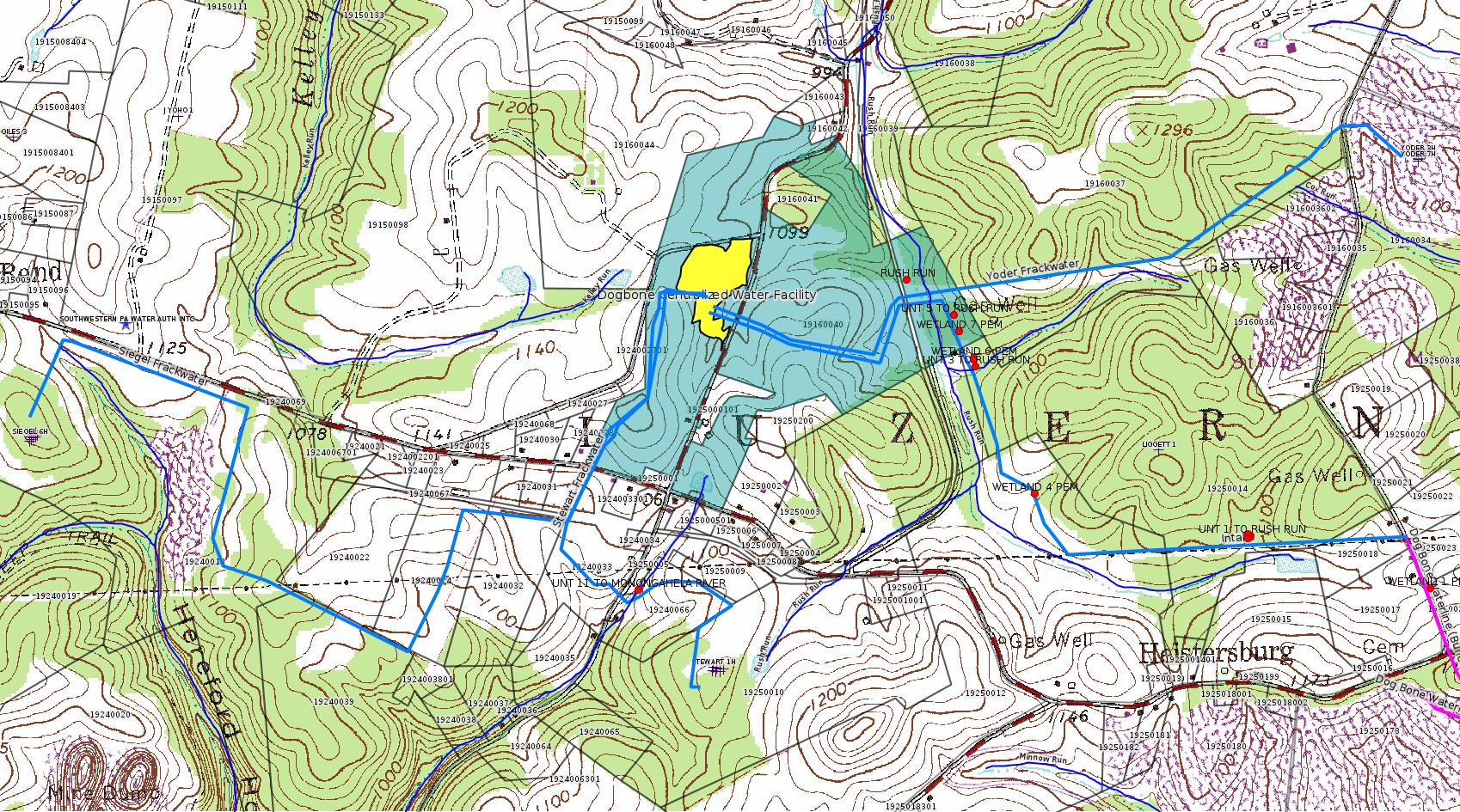
Authorization is for: FACILITY
Date received: 02/26/2018
Status: Pending
Permit Decision Guarantee Applies?: No
Sub-Facilities for Authorization:
Sub-Facility ID Sub-Facility Name Description
1255183 DOGBONE WATER LINE SYSTEM GP08260718-001 Bridge
1263383 RUSH RUN Bridge
Location: 39.972594,-79.94053
Map URL: <http://www.openstreetmap.org/?mlat=39.972594&mlon=-79.94053#map=15/39.972594/-79.94053>
1263344 UNT 1 TO RUSH RUN Bridge
Location: 39.966089,-79.929451
Map URL: <http://www.openstreetmap.org/?mlat=39.966089&mlon=-79.929451#map=15/39.966089/-79.929451>
1263387 UNT 11 TO MONONGAHELA RIVER Bridge
Location: 39.964927,-79.949358
Map URL: <http://www.openstreetmap.org/?mlat=39.964927&mlon=-79.949358#map=15/39.964927/-79.949358>
1263345 UNT 2 TO RUSH RUN Bridge
Location: 39.966133,-79.929546
Map URL: <http://www.openstreetmap.org/?mlat=39.966133&mlon=-79.929546#map=15/39.966133/-79.929546>
1263355 UNT 3 TO RUSH RUN Bridge
Location: 39.970406,-79.938318
Map URL: <http://www.openstreetmap.org/?mlat=39.970406&mlon=-79.938318#map=15/39.970406/-79.938318>
1263381 UNT 5 TO RUSH RUN Bridge
Location: 39.97171,-79.939012
Map URL: <http://www.openstreetmap.org/?mlat=39.97171&mlon=-79.939012#map=15/39.97171/-79.939012>
1263342 WETLAND 1 PEM Temporary Wetland Impact
Location: 39.964732,-79.923644
Map URL: <http://www.openstreetmap.org/?mlat=39.964732&mlon=-79.923644#map=15/39.964732/-79.923644>
1263341 WETLAND 1 PEM Bridge
Location: 39.964732,-79.923644
Map URL: <http://www.openstreetmap.org/?mlat=39.964732&mlon=-79.923644#map=15/39.964732/-79.923644>
1263349 WETLAND 2 PEM Bridge
Location: 39.966029,-79.929549
Map URL: <http://www.openstreetmap.org/?mlat=39.966029&mlon=-79.929549#map=15/39.966029/-79.929549>
1263350 WETLAND 2 PEM Temporary Wetland Impact
Location: 39.966029,-79.929549
Map URL: <http://www.openstreetmap.org/?mlat=39.966029&mlon=-79.929549#map=15/39.966029/-79.929549>
1263353 WETLAND 4 PEM Temporary Wetland Impact
Location: 39.967206,-79.936459
Map URL: <http://www.openstreetmap.org/?mlat=39.967206&mlon=-79.936459#map=15/39.967206/-79.936459>
1263352 WETLAND 4 PEM Bridge
Location: 39.967206,-79.936459
Map URL: <http://www.openstreetmap.org/?mlat=39.967206&mlon=-79.936459#map=15/39.967206/-79.936459>
1263362 WETLAND 6 Temporary Wetland Impact
Location: 39.970569,-79.93838
Map URL: <http://www.openstreetmap.org/?mlat=39.970569&mlon=-79.93838#map=15/39.970569/-79.93838>
1263356 WETLAND 6 PEM Bridge
Location: 39.970622,-79.938392
Map URL: <http://www.openstreetmap.org/?mlat=39.970622&mlon=-79.938392#map=15/39.970622/-79.938392>
1263361 WETLAND 6 PFO Bridge
Location: 39.970569,-79.93838
Map URL: <http://www.openstreetmap.org/?mlat=39.970569&mlon=-79.93838#map=15/39.970569/-79.93838>
1263371 WETLAND 7 PEM Temporary Wetland Impact
Location: 39.9713,-79.938846
Map URL: <http://www.openstreetmap.org/?mlat=39.9713&mlon=-79.938846#map=15/39.9713/-79.938846>
1263368 WETLAND 7 PEM Bridge
Location: 39.9713,-79.938846
Map URL: <http://www.openstreetmap.org/?mlat=39.9713&mlon=-79.938846#map=15/39.9713/-79.938846>
Permit Review Notes:
Date Review Note
5/2/2018 Applicant has been issued a deficiency letter. If applicable, this application no longer qualifies for the Permit Decision Guarantee.
4/20/2018 Applicant has been issued a deficiency letter. If applicable, this application no longer qualifies for the Permit Decision Guarantee.
<https://www.ahs.dep.pa.gov/eFACTSWeb/searchResults_singleAuth.aspx?AuthID=1219473>
Site Programs:
Water Planning and Conservation
Site Municipalities:
Luzerne Twp, Fayette County
Authorization ID: 1219469
Permit number: GP05260718001
Site: DOGBONE WATER LINE SYSTEM GP5 & GP8
Client: CHEVRON APPALACHIA LLC
Authorization type: GP-05 Utility Line Stream Crossings
Application type: New
Authorization is for: FACILITY
Date received: 02/26/2018
Status: Pending
Permit Decision Guarantee Applies?: Yes
Permit Decision Guarantee status: VOID
Sub-Facilities for Authorization:
Sub-Facility ID Sub-Facility Name Description
1263384 RUSH RUN Pipeline or Conduit
Location: 39.972594,-79.94053
Map URL: <http://www.openstreetmap.org/?mlat=39.972594&mlon=-79.94053#map=15/39.972594/-79.94053>
1263343 UNT 1 TO RUSH RUN Pipeline or Conduit
Location: 39.966089,-79.929451
Map URL: <http://www.openstreetmap.org/?mlat=39.966089&mlon=-79.929451#map=15/39.966089/-79.929451>
1263386 UNT 11 TO MONONGAHELA RIVER Pipeline or Conduit
Location: 39.964927,-79.949358
Map URL: <http://www.openstreetmap.org/?mlat=39.964927&mlon=-79.949358#map=15/39.964927/-79.949358>
1263346 UNT 2 TO RUSH RUN Pipeline or Conduit
Location: 39.966133,-79.929546
Map URL: <http://www.openstreetmap.org/?mlat=39.966133&mlon=-79.929546#map=15/39.966133/-79.929546>
1263354 UNT 3 TO RUSH RUN Pipeline or Conduit
Location: 39.970406,-79.938318
Map URL: <http://www.openstreetmap.org/?mlat=39.970406&mlon=-79.938318#map=15/39.970406/-79.938318>
1263374 UNT 5 TO RUSH RUN Pipeline or Conduit
Location: 39.97171,-79.939012
Map URL: <http://www.openstreetmap.org/?mlat=39.97171&mlon=-79.939012#map=15/39.97171/-79.939012>
1255180 WETLAND 1 PEM Pipeline or Conduit
Location: 39.964732,-79.923644
Map URL: <http://www.openstreetmap.org/?mlat=39.964732&mlon=-79.923644#map=15/39.964732/-79.923644>
1263342 WETLAND 1 PEM Temporary Wetland Impact
Location: 39.964732,-79.923644
Map URL: <http://www.openstreetmap.org/?mlat=39.964732&mlon=-79.923644#map=15/39.964732/-79.923644>
1263350 WETLAND 2 PEM Temporary Wetland Impact
Location: 39.966029,-79.929549
Map URL: <http://www.openstreetmap.org/?mlat=39.966029&mlon=-79.929549#map=15/39.966029/-79.929549>
1263353 WETLAND 4 PEM Temporary Wetland Impact
Location: 39.967206,-79.936459
Map URL: <http://www.openstreetmap.org/?mlat=39.967206&mlon=-79.936459#map=15/39.967206/-79.936459>
1263362 WETLAND 6 Temporary Wetland Impact
Location: 39.970569,-79.93838
Map URL: <http://www.openstreetmap.org/?mlat=39.970569&mlon=-79.93838#map=15/39.970569/-79.93838>
1263358 WETLAND 6 PFO Pipeline or Conduit
Location: 39.970569,-79.93838
Map URL: <http://www.openstreetmap.org/?mlat=39.970569&mlon=-79.93838#map=15/39.970569/-79.93838>
1263371 WETLAND 7 PEM Temporary Wetland Impact
Location: 39.9713,-79.938846
Map URL: <http://www.openstreetmap.org/?mlat=39.9713&mlon=-79.938846#map=15/39.9713/-79.938846>
1263366 WETLAND 7 PEM Pipeline or Conduit
Location: 39.9713,-79.938846
Map URL: <http://www.openstreetmap.org/?mlat=39.9713&mlon=-79.938846#map=15/39.9713/-79.938846>
Permit Review Notes:
Date Review Note
5/2/2018 Applicant has been issued a deficiency letter. If applicable, this application no longer qualifies for the Permit Decision Guarantee.
4/20/2018 Applicant has been issued a deficiency letter. If applicable, this application no longer qualifies for the Permit Decision Guarantee.
<https://www.ahs.dep.pa.gov/eFACTSWeb/searchResults_singleAuth.aspx?AuthID=1219469>
Site Programs:
Water Planning and Conservation
Site Municipalities:
Luzerne Twp, Fayette County
[Possibly Off-Topic:]
Authorization ID: 1204807
Permit number: 100419
Site: CHESTNUT VALLEY LDFL
Client: ADVANCED DSPL SVC CHESTNUT VALLEY LDFL INC
Authorization type: Landfill Pmt Final Construction Certification Form 37
Application type: Modification
Authorization is for: FACILITY
Date received: 10/31/2017
Status: Pending
Permit Decision Guarantee Applies?: Yes
Permit Decision Guarantee status: VOID
Permit Review Notes:
Date Review Note
7/17/2018 Applicant has been issued a deficiency letter. If applicable, this application no longer qualifies for the Permit Decision Guarantee.
6/21/2018 Applicant has been issued a deficiency letter. If applicable, this application no longer qualifies for the Permit Decision Guarantee.
12/27/2017 The permit application package is complete, has been accepted, and is undergoing technical review.
<https://www.ahs.dep.pa.gov/eFACTSWeb/searchResults_singleAuth.aspx?AuthID=1204807>
Site Programs:
Air Quality
Clean Water
Environmental Cleanup & Brownfields
Mining
Radiation Protection
Waste Management
Water Planning and Conservation
Site Municipalities:
German Twp, Fayette County
-------------------------
Source: DEP Oil and Gas Electronic Notifications
NOTIFICATION_ID: 42802
OGO: 39307
OPERATOR: CHEVRON APPALACHIA LLC
API_PERMIT: 051-24639
SPUD_DATE: 07/31/2018
COUNTY: Fayette
MUNICIPALITY: Luzerne
LATITUDE: 39.962917
LONGITUDE: -79.946617
SUBJECT: [NOTIFICATION]: Casing cementing notification 58 Pa. C.S. 3211(f)(2) for well API 37-051-24639-00-00
QUESTION: Enter the Date and Time for the applicable Casing Types
ANSWER: Intermediate: 8/14/2018 12:00:00 AM
SENT_DATE: 8/10/2018 3:17:08 PM
SENT_SUCCESS: Yes
LAST_RESENT_DATE:
RESENT_SUCCESS:
Well Details:
Permit Number: 051-24639
Well Name: STEWART 7H
Unconventional Well: Y
Well Configuration: Horizontal Well
Well Type: GAS
Well Status: Active
Coal Association: Coal
Conservation Well: N
Primary Facility ID: 822072
Site ID: 788124
Site Name: STEWART WELL SITE ESCGP-2 EXPEDITED
Well Pad ID: 152396
Well Pad Name: STEWART
Storage Field:
Operator: CHEVRON APPALACHIA LLC
Operator Number: OGO-39307
Permit Date: 2018-01-26
Permit Date Expires: 2019-01-26
SPUD Date: 2018-07-31
Date Plugged:
UIC ID:
UIC Type:
Surface Elevation: 1140
County: Fayette
Municipality: Luzerne Twp
Location: 39.962917,-79.946617
Map URL: <http://www.openstreetmap.org/?mlat=39.962917&mlon=-79.946617#map=15/39.962917/-79.946617>
OG WELLS PERMIT DOCS:
2018-01-26: Other Permit Documents, Name: Approval of Surface Locations by Landowners (for Authorization: 1203103):
<http://www.depgis.state.pa.us/pdfHandler/pdFHandler.ashx?Doc=NTQ5NzEz&ext=PDF>
2018-01-26: Final Permit Documents, Name: 1203103 (for Authorization: 1203103):
<http://www.depgis.state.pa.us/pdfHandler/pdFHandler.ashx?Doc=NTUxMTMw&ext=PDF>
2018-01-17: Other Permit Documents, Name: 051-24639 Alt Method (for Authorization: 1212314):
<http://www.depgis.state.pa.us/pdfHandler/pdFHandler.ashx?Doc=NTQ2MTgw&ext=PDF>
Electronically Submitted Records:
2018-01-26: Submission for Authorization 1203103
Pennsylvania Natural Diversity Inventory Form: Stewart Pad A PNDI 8-22-17.pdf
<http://www.depgis.state.pa.us/eWellDocHandler/pdFHandler.ashx?Doc=MzcwNTYy&ext=PDF>
Location Plat: Stewart Well Plats 7H.dwg
<http://www.depgis.state.pa.us/eWellDocHandler/pdFHandler.ashx?Doc=MzkxMTE3&ext=PDF>
Coal and Gas Resource Coord Act - Section 7 Exception: Stewart 1H-7H Waiver Request Section 7.pdf
<http://www.depgis.state.pa.us/eWellDocHandler/pdFHandler.ashx?Doc=MzkxMTE4&ext=PDF>
Well Cross-Section Diagram: Stewart 7H Page 4.pdf
<http://www.depgis.state.pa.us/eWellDocHandler/pdFHandler.ashx?Doc=MzkxMTE5&ext=PDF>
Well Permit Application - Coal Module: Stewart 1H-7H 2017 Coal Module.pdf
<http://www.depgis.state.pa.us/eWellDocHandler/pdFHandler.ashx?Doc=MzkxMTIw&ext=PDF>
Interested Party Notification: Stewart 1H-7H Affidavit of Non-Delivery.pdf
<http://www.depgis.state.pa.us/eWellDocHandler/pdFHandler.ashx?Doc=MzkxMTI5&ext=PDF>
Interested Party Notification: Stewart 1H-7H Affidavit of Non-Delivery.pdf
<http://www.depgis.state.pa.us/eWellDocHandler/pdFHandler.ashx?Doc=MzkxMTM4&ext=PDF>
Interested Party Notification: Stewart 1H-7H Affidavit of Non-Delivery.pdf
<http://www.depgis.state.pa.us/eWellDocHandler/pdFHandler.ashx?Doc=MzkxMTM5&ext=PDF>
Interested Party Notification: Stewart 1H-7H Affidavit of Non-Delivery.pdf
<http://www.depgis.state.pa.us/eWellDocHandler/pdFHandler.ashx?Doc=MzkxMTQw&ext=PDF>
Interested Party Notification: Stewart 1H-7H Affidavit of Non-Delivery.pdf
<http://www.depgis.state.pa.us/eWellDocHandler/pdFHandler.ashx?Doc=MzkxMTQx&ext=PDF>
Interested Party Notification: Stewart 1H-7H Affidavit of Non-Delivery.pdf
<http://www.depgis.state.pa.us/eWellDocHandler/pdFHandler.ashx?Doc=MzkxMTQ2&ext=PDF>
Permit Application to Drill and Operate a Well: 1609175.pdf
<http://www.depgis.state.pa.us/eWellDocHandler/pdFHandler.ashx?Doc=MzkyODA2&ext=PDF>
Presumed Parcel Id: 19250010
---
NOTIFICATION_ID: 42801
OGO: 39307
OPERATOR: CHEVRON APPALACHIA LLC
API_PERMIT: 051-24639
SPUD_DATE: 07/31/2018
COUNTY: Fayette
MUNICIPALITY: Luzerne
LATITUDE: 39.962917
LONGITUDE: -79.946617
SUBJECT: [NOTIFICATION]: Casing cementing notification 58 Pa. C.S. 3211(f)(2) for well API 37-051-24639-00-00
QUESTION: Enter the Date and Time for the applicable Casing Types
ANSWER: Surface: 8/11/2018 3:30:00 PM
SENT_DATE: 8/10/2018 3:16:05 PM
SENT_SUCCESS: Yes
LAST_RESENT_DATE:
RESENT_SUCCESS:
[Well info for Stewart 7H above.]
---
NOTIFICATION_ID: 42665
OGO: 61555
OPERATOR: EQT PRODUCTION CO
API_PERMIT: 051-20011
SPUD_DATE: 08/29/1959
COUNTY: Fayette
MUNICIPALITY: Henry Clay
LATITUDE: 39.84126
LONGITUDE: -79.42603
SUBJECT: [NOTIFICATION]: Abandonment or plugging notification 58 Pa. C.S. 3211(f)(2) for well API 37-051-20011-00-00
QUESTION: Date and approximate time action is to occur
ANSWER: Date: 08/06/2018 Time: 07:00 AM
SENT_DATE: 8/4/2018 7:33:53 PM
SENT_SUCCESS: Yes
LAST_RESENT_DATE:
RESENT_SUCCESS:
Well Details:
Permit Number: 051-20011
Well Name: BERTHA M & E G MUELLER 604557
Unconventional Well: N
Well Configuration: Vertical Well
Well Type: GAS
Well Status: Active
Coal Association: NonCoal
Conservation Well: N
Primary Facility ID: 42688
Site ID: 40936
Site Name: BERTHA M & E G MUELLER 604557 WELL
Well Pad ID: 0
Well Pad Name:
Storage Field:
Operator: EQT PRODUCTION CO
Operator Number: OGO-61555
Permit Date: 1901-01-01
Permit Date Expires:
SPUD Date: 1959-08-29
Date Plugged:
UIC ID:
UIC Type:
Surface Elevation: 2825
County: Fayette
Municipality: Henry Clay Twp
Location: 39.84126,-79.42603
Map URL: <http://www.openstreetmap.org/?mlat=39.84126&mlon=-79.42603#map=15/39.84126/-79.42603>
OG WELLS PERMIT DOCS:
2018-04-05: Other Permit Documents, Name: Notice of Intention to Plug a Well (for Authorization: 1223083):
<http://www.depgis.state.pa.us/pdfHandler/pdFHandler.ashx?Doc=NjI1OTc4&ext=PDF>
---
NOTIFICATION_ID: 42554
OGO: 39307
OPERATOR: CHEVRON APPALACHIA LLC
API_PERMIT: 051-24630
SPUD_DATE: 09/01/2015
COUNTY: Fayette
MUNICIPALITY: Luzerne
LATITUDE: 39.96285
LONGITUDE: -79.946747
SUBJECT: [NOTIFICATION]: Drilling resumption After Break of 30 days or more notification 58 Pa. C.S. 3211(f)(1) for well API 37-051-24630-00-00
QUESTION: Date and approximate time action is to occur
ANSWER: Date: 08/02/2018 Time: 12:00am
SENT_DATE: 7/30/2018 10:34:39 AM
SENT_SUCCESS: Yes
LAST_RESENT_DATE:
RESENT_SUCCESS:
Well Details:
Permit Number: 051-24630
Well Name: STEWART 4H
Unconventional Well: Y
Well Configuration: Horizontal Well
Well Type: GAS
Well Status: Active
Coal Association: Coal
Conservation Well: N
Primary Facility ID: 794416
Site ID: 788124
Site Name: STEWART WELL SITE ESCGP-2 EXPEDITED
Well Pad ID: 152396
Well Pad Name: STEWART
Storage Field:
Operator: CHEVRON APPALACHIA LLC
Operator Number: OGO-39307
Permit Date: 2015-07-17
Permit Date Expires: 2019-01-26
SPUD Date: 2015-09-01
Date Plugged:
UIC ID:
UIC Type:
Surface Elevation: 1145
County: Fayette
Municipality: Luzerne Twp
Location: 39.96285,-79.946747
Map URL: <http://www.openstreetmap.org/?mlat=39.96285&mlon=-79.946747#map=15/39.96285/-79.946747>
OG WELLS PERMIT DOCS:
2015-07-17: Final Permit Documents, Name: 051-24630-00-00 1077198 (for Authorization: 1077198):
<http://www.depgis.state.pa.us/pdfHandler/pdFHandler.ashx?Doc=MjExNjEy&ext=PDF>
2018-01-26: Final Permit Documents, Name: 1203100 (for Authorization: 1203100):
<http://www.depgis.state.pa.us/pdfHandler/pdFHandler.ashx?Doc=NTUxMTI0&ext=PDF>
2018-01-26: Other Permit Documents, Name: Approval of Surface Locations by Landowners (for Authorization: 1203100):
<http://www.depgis.state.pa.us/pdfHandler/pdFHandler.ashx?Doc=NTQ5NzA5&ext=PDF>
Electronically Submitted Records:
2018-01-26: Submission for Authorization 1203100
Permit Application to Drill and Operate a Well: Stewart 4H Mod Application 2017.pdf
<http://www.depgis.state.pa.us/eWellDocHandler/pdFHandler.ashx?Doc=MzkwODgz&ext=PDF>
Pennsylvania Natural Diversity Inventory Form: Stewart Pad A PNDI 8-22-17.pdf
<http://www.depgis.state.pa.us/eWellDocHandler/pdFHandler.ashx?Doc=MzkwODg0&ext=PDF>
Location Plat: Stewart Well Plats 4H.dwg
<http://www.depgis.state.pa.us/eWellDocHandler/pdFHandler.ashx?Doc=MzkwODg1&ext=PDF>
Coal and Gas Resource Coord Act - Section 7 Exception: Stewart 1H-7H Waiver Request Section 7.pdf
<http://www.depgis.state.pa.us/eWellDocHandler/pdFHandler.ashx?Doc=MzkwODg2&ext=PDF>
Well Cross-Section Diagram: Stewart 4H Page 4.pdf
<http://www.depgis.state.pa.us/eWellDocHandler/pdFHandler.ashx?Doc=MzkwODg3&ext=PDF>
Record of Notification to Interested Parties: Stewart 4H Notification of Interested Parties.pdf
<http://www.depgis.state.pa.us/eWellDocHandler/pdFHandler.ashx?Doc=MzkwODg4&ext=PDF>
Well Permit Application - Coal Module: Stewart 1H-7H 2017 Coal Module.pdf
<http://www.depgis.state.pa.us/eWellDocHandler/pdFHandler.ashx?Doc=MzkwODg5&ext=PDF>
Electronic Submission Docket: 1628612.pdf
<http://www.depgis.state.pa.us/eWellDocHandler/pdFHandler.ashx?Doc=MzkyNzc1&ext=PDF>
-------------------------
Source: Oil and Gas Compliance Report
OPERATOR: CHEVRON APPALACHIA LLC
INSPECTION_ID: 2760065
INSPECTION_DATE: 08/01/2018
INSPECTION_TYPE: Routine/Partial Inspection
API_PERMIT: 051-24485
FARM_NAME: LEE UNIT 15H
UNCONVENTIONAL: Yes
SITE_ID: 755446
SITE_NAME: LEE UNIT 14H OG WELL
FACILITY_TYPE: Oil & Gas Location
INSPECTION_CATEGORY: Primary Facility
REGION: EP DOGO SWDO Dstr Off
COUNTY: Fayette
MUNICIPALITY: Redstone Twp
INSPECTOR: NAJEWICZ, JUSTIN
INSPECTION_SOURCE: SAIR
INSPECTION_RESULT_DESCRIPTION: No Violations Noted
INSPECTION_COMMENT: On 08/01/18 at approximately 1345 hours I conducted a routine partial inspection of the site. The Act 9 sign was in place and all required documents were present at the site. Chevron had recently installed a french drain type system below the well pad to alleviate a wet spot in the field. Accelerated erosion and poor vegetative cover were observed in the recently disturbed area (see photographs). It is recommended that the erosion be repaired and additional seed and mulch be applied. Several small pieces of scrap black pipe were observed. It is recommended the scrap material be removed.
Well Details:
Permit Number: 051-24485
Well Name: LEE UNIT 15H
Unconventional Well: Y
Well Configuration: Horizontal Well
Well Type: GAS
Well Status: Active
Coal Association: Coal
Conservation Well: Y
Primary Facility ID: 747562
Site ID: 755446
Site Name: LEE UNIT 14H OG WELL
Well Pad ID: 148748
Well Pad Name: LEE UNIT
Storage Field:
Operator: CHEVRON APPALACHIA LLC
Operator Number: OGO-39307
Permit Date: 2011-12-14
Permit Date Expires: 2012-12-14
SPUD Date: 2011-12-31
Date Plugged:
UIC ID:
UIC Type:
Surface Elevation: 1022
County: Fayette
Municipality: Redstone Twp
Location: 40.003908,-79.814256
Map URL: <http://www.openstreetmap.org/?mlat=40.003908&mlon=-79.814256#map=15/40.003908/-79.814256>
---
OPERATOR: CHEVRON APPALACHIA LLC
INSPECTION_ID: 2760084
INSPECTION_DATE: 08/01/2018
INSPECTION_TYPE: Incident- Response to Accident or Event
API_PERMIT: 051-24640
FARM_NAME: KOVACH B 1
UNCONVENTIONAL: Yes
SITE_ID: 826949
SITE_NAME: KOVACH B WELL SITE AND TANK SITE ESCGP ESX17-051-0003
FACILITY_TYPE: Oil & Gas Location
INSPECTION_CATEGORY: Primary Facility
REGION: EP DOGO SWDO Dstr Off
COUNTY: Fayette
MUNICIPALITY: German Twp
INSPECTOR: NAJEWICZ, JUSTIN
INSPECTION_SOURCE: SAIR
INSPECTION_RESULT_DESCRIPTION: No Violations Noted
INSPECTION_COMMENT: "On 07/31/18 Chevron notified the Department that heavy rains had caused BMP failures at the site.
On 08/01/18 Chevron provided the Department rain gauge data showing the site received 1.32 inches of rain between 1515 and 1530 hours.
On 08/01/18 at approximately 0900 hours I conducted an incident response inspection. Sediment basin #1 had received sediment, but still had remaining volume and appeared to be structurally sound. The diversion channel leading to the sediment basin had been over run and erosion was present on the north side of the channel. The erosion channel flowed to the basin and no impacts outside the LOD were observed.
Sediment detention basin #1 also received a large amount of sediment, but still had remaining volume and appeared to be structurally sound.
On the east side of the site sediment laden water was observed leaving the LOD between the topsoil stockpile and access road slope. Erosion was also observed within the LOD at this location. At the time of inspection Chevron was repairing the access road to enable access to the east portion of the site. Chevron and the Department discussed adding temporary straw bales to redirect the sediment laden water to the south east to existing silt sock to prevent further discharge from the site. Chevron indicated the straw bales would be installed as soon as possible.
Violations of 102.4(m)5, 102.4(b)(1), and 78a.53 have occurred. See inspection ID# 2759849."
Well Details:
Permit Number: 051-24640
Well Name: KOVACH B 1
Unconventional Well: Y
Well Configuration: Vertical Well
Well Type: GAS
Well Status: Active
Coal Association: Coal
Conservation Well: N
Primary Facility ID: 823474
Site ID: 826949
Site Name: KOVACH B WELL SITE AND TANK SITE ESCGP ESX17-051-0003
Well Pad ID: 155005
Well Pad Name: KOVACH B
Storage Field:
Operator: CHEVRON APPALACHIA LLC
Operator Number: OGO-39307
Permit Date: 2018-02-22
Permit Date Expires: 2019-02-22
SPUD Date:
Date Plugged:
UIC ID:
UIC Type:
Surface Elevation: 1278
County: Fayette
Municipality: German Twp
Location: 39.918967,-79.854906
Map URL: <http://www.openstreetmap.org/?mlat=39.918967&mlon=-79.854906#map=15/39.918967/-79.854906>
OG WELLS PERMIT DOCS:
2018-02-22: Final Permit Documents, Name: 1210459 (for Authorization: 1210459):
<http://www.depgis.state.pa.us/pdfHandler/pdFHandler.ashx?Doc=NTY1ODMy&ext=PDF>
2018-02-22: Other Permit Documents, Name: RE Notification of unlocked authorization request - Authorization ID 1210459 (for Authorization: 1210459):
<http://www.depgis.state.pa.us/pdfHandler/pdFHandler.ashx?Doc=NTYyMjM4&ext=PDF>
Electronically Submitted Records:
2018-02-22: Submission for Authorization 1210459
Pennsylvania Natural Diversity Inventory Form: Kovach B PNDI.pdf
<http://www.depgis.state.pa.us/eWellDocHandler/pdFHandler.ashx?Doc=NDM0MTAy&ext=PDF>
Coal and Gas Resource Coord Act - Section 7 Exception: Kovach B Section 7 Exception.pdf
<http://www.depgis.state.pa.us/eWellDocHandler/pdFHandler.ashx?Doc=NDM0MTAz&ext=PDF>
Interested Party Notification: Affidavit of Non-Delivery Spychala.pdf
<http://www.depgis.state.pa.us/eWellDocHandler/pdFHandler.ashx?Doc=NDM0OTgx&ext=PDF>
Interested Party Notification: Affidavit of Non-Delivery Spychala.pdf
<http://www.depgis.state.pa.us/eWellDocHandler/pdFHandler.ashx?Doc=NDM0OTgz&ext=PDF>
Interested Party Notification: Affidavit of Non-Delivery Prah.pdf
<http://www.depgis.state.pa.us/eWellDocHandler/pdFHandler.ashx?Doc=NDM0OTg0&ext=PDF>
Interested Party Notification: Affidavit of Non-Delivery Prah.pdf
<http://www.depgis.state.pa.us/eWellDocHandler/pdFHandler.ashx?Doc=NDM0OTg2&ext=PDF>
Interested Party Notification: Affidavit of Non-Delivery Venere.pdf
<http://www.depgis.state.pa.us/eWellDocHandler/pdFHandler.ashx?Doc=NDM0OTg3&ext=PDF>
Interested Party Notification: Affidavit of Non-Delivery Prah.pdf
<http://www.depgis.state.pa.us/eWellDocHandler/pdFHandler.ashx?Doc=NDM0OTg5&ext=PDF>
Interested Party Notification: Affidavit of Non-Delivery Prah.pdf
<http://www.depgis.state.pa.us/eWellDocHandler/pdFHandler.ashx?Doc=NDM0OTkw&ext=PDF>
Location Plat: Kovach B 1 Plat 2-9-18.dwg
<http://www.depgis.state.pa.us/eWellDocHandler/pdFHandler.ashx?Doc=NDc5NTc4&ext=PDF>
Permit Application to Drill and Operate a Well: 1654493.pdf
<http://www.depgis.state.pa.us/eWellDocHandler/pdFHandler.ashx?Doc=NDg4MzE1&ext=PDF>
---
OPERATOR: CHEVRON APPALACHIA LLC
INSPECTION_ID: 2761586
INSPECTION_DATE: 08/08/2018
INSPECTION_TYPE: Drilling/Alteration
API_PERMIT: 051-24639
FARM_NAME: STEWART 7H
UNCONVENTIONAL: Yes
SITE_ID: 788124
SITE_NAME: STEWART WELL SITE ESCGP-2 EXPEDITED
FACILITY_TYPE: Oil & Gas Location
INSPECTION_CATEGORY: Primary Facility
REGION: EP DOGO SWDO Dstr Off
COUNTY: Fayette
MUNICIPALITY: Luzerne Twp
INSPECTOR: PETERSON, ERIC
INSPECTION_SOURCE: SUBSAIR
INSPECTION_RESULT_DESCRIPTION: No Violations Noted
INSPECTION_COMMENT: "Highlands #14 setting up to pull csg weight+ in attempt to remove short coal string. 40K# pulled with no movement. 60K# pulled with approx. one inch stretch. Operator determined to shoot casing and pull.
Safety meeting held prior to wireline shot. Rig set to pull 15-20K# over floating weight to keep pipe in tension.
NOVIO"
OPERATOR: CHEVRON APPALACHIA LLC
INSPECTION_ID: 2762201
INSPECTION_DATE: 08/09/2018
INSPECTION_TYPE: Drilling/Alteration
API_PERMIT: 051-24639
FARM_NAME: STEWART 7H
UNCONVENTIONAL: Yes
SITE_ID: 788124
SITE_NAME: STEWART WELL SITE ESCGP-2 EXPEDITED
FACILITY_TYPE: Oil & Gas Location
INSPECTION_CATEGORY: Primary Facility
REGION: EP DOGO SWDO Dstr Off
COUNTY: Fayette
MUNICIPALITY: Luzerne Twp
INSPECTOR: PETERSON, ERIC
INSPECTION_SOURCE: SUBSAIR
INSPECTION_RESULT_DESCRIPTION: No Violations Noted
INSPECTION_COMMENT: Operator attempted several times to pull coal csg string without success. Based on OGI approval operator perforated csg, RIH with drill string to approved TD and set a cement plug in open hole and extending above two sets of perforations. Operator has tagged top of plug and is prepping to cement last plug to surface. NOVIO
VIOLATION_ID:
VIOLATION_DATE:
[Well info above.]
[See Notes.]
---
OPERATOR: DIVERSIFIED OIL & GAS LLC
INSPECTION_ID: 2762483
INSPECTION_DATE: 08/10/2018
INSPECTION_TYPE: Routine/Complete Inspection
API_PERMIT: 051-24267
FARM_NAME: FAY-PENN 44
UNCONVENTIONAL: Yes
SITE_ID: 724387
SITE_NAME: FAY-PENN 44 OG WELL
FACILITY_TYPE: Oil & Gas Location
INSPECTION_CATEGORY: Primary Facility
REGION: EP DOGO SWDO Dstr Off
COUNTY: Fayette
MUNICIPALITY: Springhill Twp
INSPECTOR: NAJEWICZ, JUSTIN
INSPECTION_SOURCE: SAIR
INSPECTION_RESULT_DESCRIPTION: No Violations Noted
INSPECTION_COMMENT: The Act 9 sign was in place. The site was well vegetated and there were no signs of erosion observed. The brine tanks exhibited signs of corrosion. It is recommended the tanks be inspected for structural integrity.
Well Details:
Permit Number: 051-24267
Well Name: FAY-PENN 44
Unconventional Well: Y
Well Configuration: Vertical Well
Well Type: GAS
Well Status: Active
Coal Association: Coal
Conservation Well: Y
Primary Facility ID: 722392
Site ID: 724387
Site Name: FAY-PENN 44 OG WELL
Well Pad ID: 147498
Well Pad Name: FAY-PENN 44
Storage Field:
Operator: DIVERSIFIED OIL & GAS LLC
Operator Number: OGO-68792
Permit Date: 2009-09-18
Permit Date Expires: 2010-09-18
SPUD Date: 2009-09-27
Date Plugged:
UIC ID:
UIC Type:
Surface Elevation: 1141
County: Fayette
Municipality: Springhill Twp
Location: 39.748776,-79.844685
Map URL: <http://www.openstreetmap.org/?mlat=39.748776&mlon=-79.844685#map=15/39.748776/-79.844685>
Presumed Parcel Id: 36080105
---
[Conventional Well:]
OPERATOR: RANGE RESOURCES APPALACHIA LLC
INSPECTION_ID: 2762187
INSPECTION_DATE: 08/07/2018
INSPECTION_TYPE: Incident- Response to Accident or Event
API_PERMIT: 051-22443
FARM_NAME: CUSTER UNIT 1
UNCONVENTIONAL: No
SITE_ID: 646282
SITE_NAME: CUSTER UNIT 1 OG WELL
FACILITY_TYPE: Oil & Gas Location
INSPECTION_CATEGORY: Primary Facility
REGION: EP DOGO SWDO Dstr Off
COUNTY: Fayette
MUNICIPALITY: Lower Tyrone Twp
INSPECTOR: NAJEWICZ, JUSTIN
INSPECTION_SOURCE: SAIR
INSPECTION_RESULT_DESCRIPTION: Violation(s) Noted
INSPECTION_COMMENT: "On 08/02/18 at approximately 1700 hours a Range production supervisor observed the poly brine tank nipple/valve was leaking. The brine tank did not have secondary containment. Range reported the release was believed to be 5 barrels of produced water. The leak was stopped with a band clamp and the remaining fluid was hauled off.
On 08/07/18 at approximately 1500 hours an incident response inspection was conducted. The brine tank had been drained and removed. Five roll off boxes were present at the site. The area downslope of the well head had been excavated to remove impacted material. In an email received by the Department on 08/06/18 Range Resources indicated they would be remediating the release in accordance with the alternate method described in DEP Spill Policy."
VIOLATION_ID: 824896
VIOLATION_DATE: 08/02/2018
VIOLATION_CODE: SWMA 301 - MANAGEMENT OF RESIDUAL WASTE - Person operated a residual waste processing or disposal facility without obtaining a permit for such facility from DEP. Person stored, transported, processed, or disposed of residual waste inconsistent with or unauthorized by the rules and regulations of DEP.
VIOLATION_TYPE: Environmental Health & Safety
VIOLATION_COMMENT:
RESOLVED_DATE:
RESOLUTION_REASON_CODE_DESCRIPTION:
CONTINUING_VIOLATION:
ENFORCEMENT_ID: 366491
ENFORCEMENT_CODE_DESCRIPTION: NOV - Notice of Violation
DATE_EXECUTED: 08/10/2018
ENFORCEMENT_FINAL_DATE:
ENFORCEMENT_FINAL_STATUS:
PENALTY_FINAL_DATE:
PENALTY_FINAL_STATUS_CODE_DESCRIPTION:
PENALTY_AMOUNT:
TOTAL_AMOUNT_COLLECTED:
Well Details:
Permit Number: 051-22443
Well Name: CUSTER UNIT 1
Unconventional Well: N
Well Configuration: Vertical Well
Well Type: GAS
Well Status: Active
Coal Association: NonCoal
Conservation Well: N
Primary Facility ID: 660888
Site ID: 646282
Site Name: CUSTER UNIT 1 OG WELL
Well Pad ID: 0
Well Pad Name:
Storage Field:
Operator: RANGE RESOURCES APPALACHIA LLC
Operator Number: OGO-60915
Permit Date: 2004-11-10
Permit Date Expires: 2005-11-10
SPUD Date: 2005-02-10
Date Plugged:
UIC ID:
UIC Type:
Surface Elevation: 880
County: Fayette
Municipality: Lower Tyrone Twp
Location: 40.051413,-79.663922
Map URL: <http://www.openstreetmap.org/?mlat=40.051413&mlon=-79.663922#map=15/40.051413/-79.663922>
Presumed Parcel Id: 18070054
-------------------------
Source: DEP SPUD (drilling started) Report
API: 051-24639
OGO_NUM: OGO-39307
OPERATOR: CHEVRON APPALACHIA LLC
REGION: EP DOGO SWDO Dstr Off
COUNTY: Fayette
MUNICIPALITY: Luzerne Twp
FARM_NAME: STEWART 7H
WELL_CODE_DESC: GAS
WELL_STATUS: Active
LATITUDE: 39.96
LONGITUDE: -79.95
CONFIGURATION: Horizontal Well
UNCONVENTIONAL: Yes
[Well info above.]
------------------------
Source: Reuters Commodities: Energy
| Commodity | Exchange | Currency | Expire | Last Trade | Trade Time | Change | Open | Day's High | Day's Low |
|---|---|---|---|---|---|---|---|---|---|
| NATURAL
GAS CON1 Aug18 |
NYM | USD | 08/29 | 2.94 | 08/15 14:18 | -0.02 | 2.95 | 2.96 | 2.93 |
<http://www.reuters.com/finance/commodities/energy>
-------------------------
Notes:
Stewart 7H is "new" -- i.e. was not SPUD until Chevron resumed drilling after its approximately 2 1/2 year hiatus. The Stewart Well Pad is a deeply troubled site.
------------------------
DEP defines an environmental justice area as "any census tract where 20 percent or more individuals live in poverty, and/or 30 percent or more of the population is minority". (See:
<http://www.dep.pa.gov/PublicParticipation/OfficeofEnvironmentalJustice/Pages/default.aspx>). There are supposed to be enhanced public participation requirements for permits in environmental justice areas, but news of this actually ever happening is scarce. In Fayette County, the entirety of Springhill, Nicholson, German, and Georges Townships are environmental justice areas, as well as a large part of Dunbar Township. DEP's policy document on public participation guidelines for environmental justice areas is located here:
<http://www.elibrary.dep.state.pa.us/dsweb/Get/Version-48671/012-0501-002.pdf>
eNOTICE records are likely to list the same permit multiple times, as that permit moves through the DEP process.
Oil & Gas Wells designated with a site a number and the letter H typically designate horizontal wells.
-------------------------
Resources:
Pennsylvania Bulletin: <http://www.pabulletin.com/>
eNOTICE: <http://www.ahs2.dep.state.pa.
DEP Oil and Gas Reports: <http://www.dep.pa.gov/DataandTools/Reports/Oil%20and%20Gas%20Reports/Pages/default.aspx>
DEP Permits Issued Detail Report:
<http://www.depreportingservic
DEP SPUD (drilling started) Report:
<http://www.depreportingservices.state.pa.us/ReportServer/Pages/ReportViewer.aspx?/Oil_Gas/Spud_External_Data>
DEP Oil and Gas Compliance Report:
<http://www.depreportingservices.state.pa.us/ReportServer/Pages/ReportViewer.aspx?/Oil_Gas/OG_Compliance>
DEP PA Oil & Gas Mapping:
<http://www.depgis.state.pa.us/PaOilAndGasMapping>
Data Portal Services Directory [Technical]
<http://www.depgis.state.pa.us/arcgis/rest/services>
Query: Oil and Gas Wells All (ID: 3) [Technical]:
<http://www.depgis.state.pa.us/arcgis/rest/services/OilGas/OilGasAllStrayGasEGSP/MapServer/3/query?where=&text=&objectIds=&time=&geometry=&geometryType=esriGeometryEnvelope&inSR=&spatialRel=esriSpatialRelIntersects&relationParam=&outFields=*&returnGeometry=true&returnTrueCurves=false&maxAllowableOffset=&geometryPrecision=&outSR=&returnIdsOnly=false&returnCountOnly=false&orderByFields=&groupByFieldsForStatistics=&outStatistics=&returnZ=false&returnM=false&gdbVersion=&returnDistinctValues=false&resultOffset=&resultRecordCount=&f=html>
(Be sure to enter a Where clause in SQL format. Dates are in milliseconds since midnight 1/1/1970).
New:
DEP Oil and Gas Electronic Submissions
<http://www.ahs.dep.pa.gov/eSubmissionPublicSearch>
DEP Oil and Gas Electronic Notifications
<http://www.depreportingservices.state.pa.us/ReportServer?/Oil_Gas/OG_Notifications>
DEP Oil and Gas Well Pad Report
<http://www.depreportingservices.state.pa.us/ReportServer?/Oil_Gas/Well_Pads>
Fayette County Assessment Office Search For Tax Records:
<http://property.co.fayette.pa.us/search.aspx>
Pennsylvania Spatial Data Access:
<http://www.pasda.psu.edu/default.asp>
DEP Spatial Data Repository:
<ftp://www.pasda.psu.edu/pub/pasda/dep/>
National Response Center:
<http://www.nrc.uscg.mil/>
EPA-Echo: <http://www.epa-echo.gov/echo/
FERC citizen involvement: <http://www.ferc.gov/for-citiz
To receive E-mail notification of
all documents filed in a FERC docket, see:
<http://www.ferc.gov/docs-filing/esubscription.asp >
<http://www.ferc.gov/docs-fili
Follow the directions and enter the docket number to subscribe to.
Township Supervisors receive information regarding Erosion & Sedimentation permits, and these records may be reviewable at township municipal offices.
DEP permits are reviewable through the File Review process, for application to do file review see: <http://www.portal.state.pa.us/portal/server.pt/community/southwest_regional_office/13775/file_review/593164>
Environmental Hearing Board: <http://ehb.courtapps.com/publ
PA DEP Environmental Policy Comment System:
<http://www.ahs.dep.pa.gov/eComment/>
Federal Register Environment: <https://www.federalregister.g
Browsing of recent comment
opportunities for federal agencies, e.g. EPA. Click "sign up" to
subscribe to daily E-mails of new document listings.
SkyTruth Fayette County Drilling Alerts: <http://frack.skytruth.org/pen
U.S. Army Corps of Engineers, Pittsburgh District, Public Notices:
<http://www.lrp.usace.army.mil/Missions/Regulatory/Public-Notices/>
EPA Pennsylvania Public Notices: <http://www2.epa.gov/aboutepa/epa-pennsylvania#notice>
Marcellus Shale waste disposal
injection wells in Pennsylvania are regulated directly by EPA, not
DEP. Notice of any new permit applications will appear at the
above web address. I'm not aware of any subscription service
to be notified of such applications. I'm not aware of any
Marcellus Shale waste disposal injection wells in Fayette County
(yet ...) but we need to monitor this page for future
applications.
Energy Assurance Daily: <http://www.oe.netl.doe.gov/ead.aspx>
Daily newsletter from the US
Department of Energy about events relating to energy. The Natural
Gas section has information about pipelines.
-------------------------
Disclaimers:
This compilation from the above sources was done in part by hand using copy and paste and in part using automated methods; it may omit relevant permits.
Parcel data is provided via the tax records search web page offered by the Fayette County Assessment Office (http://property.co.fayette.pa.us/). Presumed Parcel Id links are subject to availability provided by that agency and associated web sites. Presumed Parcel Ids are determined as the mapped parcel containing a given latitude and longitude, are a best effort determination which is subject to error, and are not official. In cases where a facility is leased and there is a separate parcel id for the lease, if this parcel id is not separately mapped, the parcel id shown will be the id for the enclosing parcel. Parcel owners may be surface owners only and may or may not have any relationship to oil & gas facilities.
Does not currently include water supply permits. Does not include landfill permits even though many such are for Marcellus Shale waste. (It is not possible at this time to distinguish which landfill permits are for Marcellus Shale waste and which are not without doing File Review for each permit.)
Erosion & Sedimentation permit records do not currently include latitude and longitude. Where I am publishing latitude and longitude with E&S permits it is by inferring an associated well permit and using published latitude and longitude for the well. It is possible I may be inferring the wrong well site.
Municipalities are shown from eFACTS records on the DEP web site. The DEP has been known to list a municipality incorrectly.