The Harmed Success Stories Concepts How To What Is Commentary
Fayette County Marcellus Shale Permits 8/10/20 - 8/23/20
Contents
Pennsylvania Bulletin Listings
[No Activity]eFACTS Listings
DAWSON TP Water Quality Mgmt Part II, Industrial Wastewater Fac 8/18/2020 deficiency letter (New)
DAWSON TP Minor IW Facility without ELG 8/18/2020 deficiency letter (New)
APOLLO RESOURCES LLC/CONNELSVILLE COMPRESSOR STA AQ GP 5 - Natural Gas Compression and/or Processing Facilities (New)
DYNEGY FAYETTE II LLC Major Facility Plan Approval New Source Performance Std Extension (New)
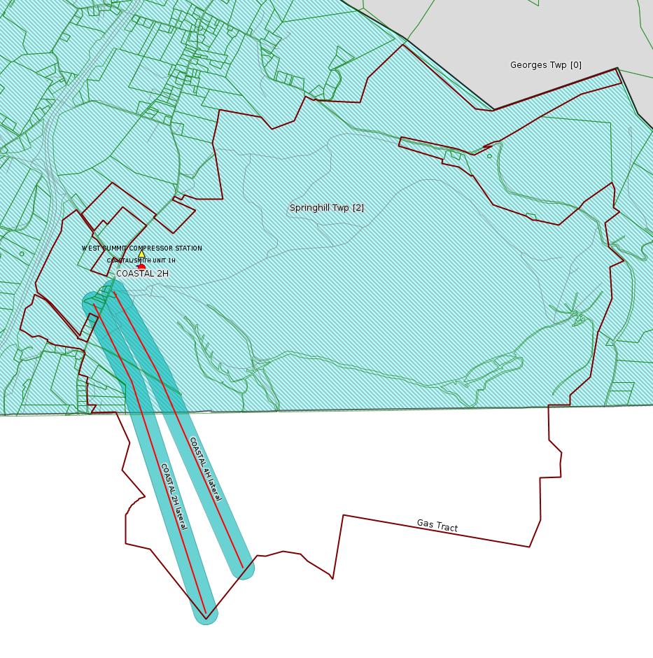
COASTAL 2H Drill & Operate Well Permit (Unconventional) 8/18/2020 deficiency letter (New)
COASTAL 4H Drill & Operate Well Permit (Unconventional )8/18/2020 deficiency letter (New)
RONCO RW General Permit Renewal, Fac
TEXAS EASTERN TRANS FAYETTE CNTY GP-05 Utility Line Stream Crossings
CHESTNUT VALLEY LDFL Landfill Permit Form 37(per component) 8/21/2020 deficiency letter
SHOAF NORTH CENTRALIZED FRESHWATER IMPOUNDMENT Erosion and Sediment Control GP-2 [Termination?] Notification
DOGBONE CENTRALIZED WATER FACILITY RW General Permit Renewal, Fac 8/19/2020 deficiency letter
R E EBERLY TRUST ET AL 3 Stimulation notification: 09/01/2020Price of Natural Gas
R E EBERLY TRUST ET AL 4 Stimulation notification: 09/02/2020
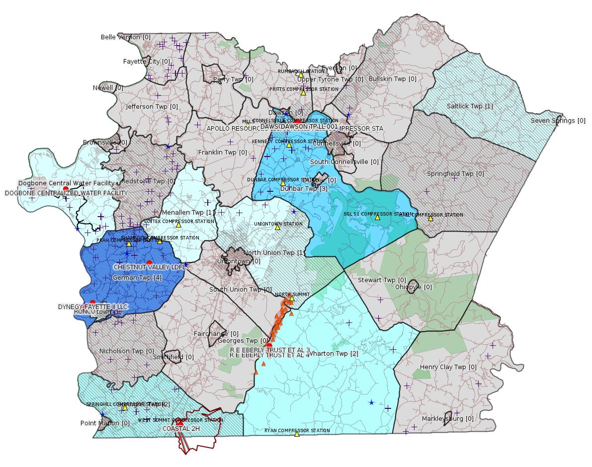
Map
Key
Red dots: items in this permit list with an exact location.
Blue stars: Marcellus Gas Well Water Sources.
Where well laterals are mapped they show in red; a 400-foot buffer surrounding the lateral shows in blue (lavender where it overlaps a mapped mineral tract).
Where mineral tracts are mapped, they show in pink. Mineral tracts can overlap; the overlap will show in red. The precise meaning of "mineral tract" is not clear.
Municipality shading: number of "facilities", with each well counting separately
(includes the red dots):
gray: 0
pale turquoise: 1
turquoise: 2
pale blue: 3
middle blue: 4
dark blue: 5
dark purple: 6
purple: 18
(Color coding may differ from one issue to the next.)
(Note if a project spans multiple municipalities -- e.g. a pipeline -- it will show in the count for each municipality.)
The number of facilities also follows the municipality name in brackets.
Municipality counts are based on the way the permit is listed by DEP; DEP has been known to get a municipality wrong.
Locations in brackets identify a precise location used to locate a surrogate for the actual site being permitted (e.g. locating a well pad or pipeline by the known location of a well.) Locations labeled beginning with "~" and ending in "[?]" are approximate and speculative based on inferences using on-line property and lease records. These are marked in the text as "[Approximate, Speculative]
Cross-hatching: Environmental Justice Areas
Yellow triangles: Compressor Stations
Orange triangles: Storage Field Wells (currently Dominion North Summit Storage Field)
Crosses: SPUD Unconventional well permits
Green: "Natural areas", e.g. state game lands, state forests
Yellow triangles: Compressor Stations
Orange triangles: Storage Field Wells (currently Dominion North Summit Storage Field)
Crosses: SPUD Unconventional well permits
Green: "Natural areas", e.g. state game lands, state forests
More Maps
 |
 |
 |
Source: Pennsylvania Bulletin
[No Activity]
-------------------------
Source: eNOTICE
(+ PA
Oil and Gas Mapping, Well
Pad Report.) Well Details via Data
Portal Services: Oil and Gas Wells All (ID: 3).
Please see the Disclaimer below regarding Parcel Id data.
Authorization ID: 1323787
Permit number: 2698201
Site: DAWSON TP
Client: APOLLO RESOURCES LLC
Authorization type: Water Quality Mgmt Part II, Industrial Wastewater Fac
Application type: Transfer
Authorization is for: FACILITY
Date received: 07/24/2020
Status: Pending
Permit Decision Guarantee Applies?: No
Sub-Facilities for Authorization:
Sub-Facility ID Sub-Facility Name Description
1025461 TRMT PLANT Treatment Plant
Location: 40.036413,-79.640588
Map URL: <http://www.openstreetmap.org/?mlat=40.036413&mlon=-79.640588#map=15/40.036413/-79.640588>
Permit Review Notes:
Date Review Note
8/18/2020 Applicant has been issued a deficiency letter. If applicable, this application no longer qualifies for the Permit Decision Guarantee.
<https://www.ahs.dep.pa.gov/eFACTSWeb/searchResults_singleAuth.aspx?AuthID=1323787>
Site Programs:
Clean Water
Oil & Gas
Site Municipalities:
Dunbar Twp, Fayette County
Presumed Parcel Id: 09050007
[See Notes.]
---
Authorization ID: 1323785
Permit number: PA0217778
Site: DAWSON TP
Client: APOLLO RESOURCES LLC
Authorization type: Minor IW Facility without ELG
Application type: Transfer
Authorization is for: FACILITY
Date received: 07/24/2020
Status: Pending
Permit Decision Guarantee Applies?: No
Sub-Facilities for Authorization:
Sub-Facility ID Sub-Facility Name Description
1025459 OUTFALL 001 Discharge Point
Location: 40.036247,-79.640533
Map URL: <http://www.openstreetmap.org/?mlat=40.036247&mlon=-79.640533#map=15/40.036247/-79.640533>
Permit Review Notes:
Date Review Note
8/18/2020 Applicant has been issued a deficiency letter. If applicable, this application no longer qualifies for the Permit Decision Guarantee.
<https://www.ahs.dep.pa.gov/eFACTSWeb/searchResults_singleAuth.aspx?AuthID=1323785>
Site Programs:
Clean Water
Oil & Gas
Site Municipalities:
Dunbar Twp, Fayette County
Presumed Parcel Id: 09050007
---
Authorization ID: 1323030
Permit number: GP5-26-00544D
Site: APOLLO RESOURCES LLC/CONNELSVILLE COMPRESSOR STA
Client: APOLLO RESOURCES LLC
Authorization type: AQ GP 5 - Natural Gas Compression and/or Processing Facilities
Application type: New
Authorization is for: FACILITY
Date received: 07/23/2020
Status: Pending
Permit Decision Guarantee Applies?: No
<https://www.ahs.dep.pa.gov/eFACTSWeb/searchResults_singleAuth.aspx?AuthID=1323030>
Site Programs:
Air Quality
Site Municipalities:
Dunbar Twp, Fayette County
---
Authorization ID: 1323017
Permit number: 26-00535B
Site: DYNEGY FAYETTE II LLC
Client: DYNEGY FAYETTE II LLC
Authorization type: Major Facility Plan Approval New Source Performance Std
Application type: Extension
Authorization is for: FACILITY
Date received: 08/03/2020
Status: Pending
Permit Decision Guarantee Applies?: No
Sub-Facilities for Authorization:
Sub-Facility ID Sub-Facility Name Description
805961 CGT STACK 1 Point of Air Emission
805962 CGT STACK 2 Point of Air Emission
805954 CGT TRAIN 1 COMBINED CYCLE TURBINE Process
805959 CGT TRAIN 2 COMBINED CYCLE TURBINE Process
1095705 OXIDATION CATALYST UNIT 1 Air Pollution Control Device
Location: 39.857408,-79.913878
Map URL: <http://www.openstreetmap.org/?mlat=39.857408&mlon=-79.913878#map=15/39.857408/-79.913878>
1095706 OXIDATION CATALYST UNIT 2 Air Pollution Control Device
Location: 39.857408,-79.913878
Map URL: <http://www.openstreetmap.org/?mlat=39.857408&mlon=-79.913878#map=15/39.857408/-79.913878>
1095701 SCR UNIT 1 Air Pollution Control Device
Location: 39.857408,-79.913878
Map URL: <http://www.openstreetmap.org/?mlat=39.857408&mlon=-79.913878#map=15/39.857408/-79.913878>
1095702 SCR UNIT 2 Air Pollution Control Device
Location: 39.857408,-79.913878
Map URL: <http://www.openstreetmap.org/?mlat=39.857408&mlon=-79.913878#map=15/39.857408/-79.913878>
Permit Review Notes:
Date Review Note
8/20/2020 The technical review and decision review are complete and either the permit decision and/or permit issuance are forthcoming.
8/12/2020 The permit application package is complete, has been accepted, and is undergoing technical review.
<https://www.ahs.dep.pa.gov/eFACTSWeb/searchResults_singleAuth.aspx?AuthID=1323017>
Site Programs:
Air Quality
Waste Management
Water Planning and Conservation
Site Municipalities:
German Twp, Fayette County
Masontown Boro [apparently incorrect -jr], Fayette County
---
Authorization ID: 1322984
Permit number: 051-24722
Site: COASTAL 1H FLOW BACK PIT FRESHWATER PITS ESCGP-EXPEDITED
Client: INR OPR LLC
Authorization type: Drill & Operate Well Permit (Unconventional)
Application type: New
Authorization is for: FACILITY
Date received: 08/11/2020
Status: Pending
Permit Decision Guarantee Applies?: Yes
Permit Decision Guarantee status: VOID
Sub-Facilities for Authorization:
Sub-Facility ID Sub-Facility Name Description
1313193 WELLBORE SURFACE HOLE LOCATION Well
Permit Review Notes:
Date Review Note
8/18/2020 Applicant has been issued a deficiency letter. If applicable, this application no longer qualifies for the Permit Decision Guarantee.
8/12/2020 The permit application package is complete, has been accepted, and is undergoing technical review.
<https://www.ahs.dep.pa.gov/eFACTSWeb/searchResults_singleAuth.aspx?AuthID=1322984>
Site Programs:
Oil & Gas
Site Municipalities:
Springhill Twp, Fayette County
Well Details:
Permit Number: 051-24722
Well Name: COASTAL 2H
Unconventional Well: Y
Well Configuration: Horizontal Well
Well Type: GAS
Well Status: Active
Coal Association: Coal
Conservation Well: N
Primary Facility ID: 843825
Site ID: 739525
Site Name: COASTAL 1H FLOW BACK PIT FRESHWATER PITS ESCGP-EXPEDITED
Well Pad ID: 147971
Well Pad Name: COASTAL WELL PAD
Storage Field:
Operator: INR OPR LLC
Operator Number: OGO-51036
Permit Date:
Permit Date Expires:
SPUD Date:
Date Plugged:
UIC ID:
UIC Type:
Surface Elevation: 1127
County: Fayette
Municipality: Springhill Twp
Location: 39.73315,-79.800903
Map URL: <http://www.openstreetmap.org/?mlat=39.73315&mlon=-79.800903#map=15/39.73315/-79.800903>
Electronically Submitted Records:
2020-08-21: Submission for Authorization 1322984
Interested Party Notification: Coastal 2H - Springhill Township - Interested Party Signed Receipt - 08.04.2020.pdf
<http://www.depgis.state.pa.us/eWellDocHandler/pdFHandler.ashx?Doc=MTI1MjgxNw==&ext=PDF>
Coordination of Well Location with Public Resources: INR OPERATING - COASTAL 2H - COORDINATION_OF_WELL_LOCATION_WITH_PUBLIC_RESOURCES.pdf
<http://www.depgis.state.pa.us/eWellDocHandler/pdFHandler.ashx?Doc=MTI2MTg1Mg==&ext=PDF>
Pennsylvania Natural Diversity Inventory Form: INR OPERATING - COASTAL 2H - PNDI INVENTORY 07.21.2020.pdf
<http://www.depgis.state.pa.us/eWellDocHandler/pdFHandler.ashx?Doc=MTI2MTg1Mw==&ext=PDF>
Pennsylvania Natural Diversity Inventory Support Document: INR OPERATING - COASTAL 2H - PNDI SUPPORT 07.21.2020.pdf
<http://www.depgis.state.pa.us/eWellDocHandler/pdFHandler.ashx?Doc=MTI2MTg1NQ==&ext=PDF>
Operator Ownership and Control Information: INR OPERATING - COASTAL 2H - OPERATOR_OWNERSHIP_AND_CONTROL_INFORMATION_FORM 07.21.2020.pdf
<http://www.depgis.state.pa.us/eWellDocHandler/pdFHandler.ashx?Doc=MTI2MTg1Ng==&ext=PDF>
Well Cross-Section Diagram: Coastal 2H Well Plat 08.04.2020.pdf
<http://www.depgis.state.pa.us/eWellDocHandler/pdFHandler.ashx?Doc=MTI2MTg1Nw==&ext=PDF>
Well Permit Application - Coal Module: INR OPERATING - COASTAL 2H - COAL STATUS REPORT 07.24.2020.pdf
<http://www.depgis.state.pa.us/eWellDocHandler/pdFHandler.ashx?Doc=MTI2MTg1OA==&ext=PDF>
Location Plat: INR OPERATING - COASTAL 2H - LOCATION PLAT 08.04.2020.dwg
<http://www.depgis.state.pa.us/eWellDocHandler/pdFHandler.ashx?Doc=MTI2MTg5Mg==&ext=PDF>
Permit Application to Drill and Operate a Well: 1958801.pdf
<http://www.depgis.state.pa.us/eWellDocHandler/pdFHandler.ashx?Doc=MTI2NDA4Ng==&ext=PDF>
[See Notes.]
---
Authorization ID: 1322978
Permit number: 051-24721
Site: COASTAL 1H FLOW BACK PIT FRESHWATER PITS ESCGP-EXPEDITED
Client: INR OPR LLC
Authorization type: Drill & Operate Well Permit (Unconventional)
Application type: New
Authorization is for: FACILITY
Date received: 08/11/2020
Status: Pending
Permit Decision Guarantee Applies?: Yes
Permit Decision Guarantee status: VOID
Sub-Facilities for Authorization:
Sub-Facility ID Sub-Facility Name Description
1313192 WELLBORE SURFACE HOLE LOCATION Well
Permit Review Notes:
Date Review Note
8/18/2020 Applicant has been issued a deficiency letter. If applicable, this application no longer qualifies for the Permit Decision Guarantee.
8/12/2020 The permit application package is complete, has been accepted, and is undergoing technical review.
<https://www.ahs.dep.pa.gov/eFACTSWeb/searchResults_singleAuth.aspx?AuthID=1322978>
Site Programs:
Oil & Gas
Site Municipalities:
Springhill Twp, Fayette County
Well Details:
Permit Number: 051-24721
Well Name: COASTAL 4H
Unconventional Well: Y
Well Configuration: Horizontal Well
Well Type: GAS
Well Status: Active
Coal Association: Coal
Conservation Well: N
Primary Facility ID: 843824
Site ID: 739525
Site Name: COASTAL 1H FLOW BACK PIT FRESHWATER PITS ESCGP-EXPEDITED
Well Pad ID: 147971
Well Pad Name: COASTAL WELL PAD
Storage Field:
Operator: INR OPR LLC
Operator Number: OGO-51036
Permit Date:
Permit Date Expires:
SPUD Date:
Date Plugged:
UIC ID:
UIC Type:
Surface Elevation: 1127
County: Fayette
Municipality: Springhill Twp
Location: 39.733181,-79.800869
Map URL: <http://www.openstreetmap.org/?mlat=39.733181&mlon=-79.800869#map=15/39.733181/-79.800869>
Electronically Submitted Records:
2020-08-21: Submission for Authorization 1322978
Pennsylvania Natural Diversity Inventory Form: INR OPERATING - COASTAL 4H - PNDI INVENTORY 07.21.2020.pdf
<http://www.depgis.state.pa.us/eWellDocHandler/pdFHandler.ashx?Doc=MTIzMzcxOQ==&ext=PDF>
Pennsylvania Natural Diversity Inventory Support Document: INR OPERATING - COASTAL 4H - PNDI SUPPORT 07.21.2020.pdf
<http://www.depgis.state.pa.us/eWellDocHandler/pdFHandler.ashx?Doc=MTIzMzcyMQ==&ext=PDF>
Operator Ownership and Control Information: INR OPERATING - COASTAL 4H - OPERATOR_OWNERSHIP_AND_CONTROL_INFORMATION_FORM 07.21.2020.pdf
<http://www.depgis.state.pa.us/eWellDocHandler/pdFHandler.ashx?Doc=MTIzMzcyMg==&ext=PDF>
Coordination of Well Location with Public Resources: INR OPERATING - COASTAL 4H - COORDINATION_OF_WELL_LOCATION_WITH_PUBLIC_RESOURCES.pdf
<http://www.depgis.state.pa.us/eWellDocHandler/pdFHandler.ashx?Doc=MTIzNjcxMQ==&ext=PDF>
Well Permit Application - Coal Module: INR OPERATING - COASTAL 4H - COAL STATUS REPORT 07.24.2020.pdf
<http://www.depgis.state.pa.us/eWellDocHandler/pdFHandler.ashx?Doc=MTIzOTY5MA==&ext=PDF>
Location Plat: INR OPERATING - COASTAL 4H - LOCATION PLAT 08.04.2020.dwg
<http://www.depgis.state.pa.us/eWellDocHandler/pdFHandler.ashx?Doc=MTI1MjM1Nw==&ext=PDF>
Interested Party Notification: Coastal 4H - Springhill Township - Interested Party Signed Receipt - 08.04.2020.pdf
<http://www.depgis.state.pa.us/eWellDocHandler/pdFHandler.ashx?Doc=MTI1MjgyNA==&ext=PDF>
Well Cross-Section Diagram: Coastal 4H Well Plat 08.04.2020.pdf
<http://www.depgis.state.pa.us/eWellDocHandler/pdFHandler.ashx?Doc=MTI2MTgwMQ==&ext=PDF>
Permit Application to Drill and Operate a Well: 2141432.pdf
<http://www.depgis.state.pa.us/eWellDocHandler/pdFHandler.ashx?Doc=MTI2NDIxMA==&ext=PDF>
---
Authorization ID: 1322280
Permit number: WMGR123SW001
Site: RONCO
Client: SHALLENBERGER CONST INC
Authorization type: RW General Permit Renewal, Fac
Application type: Renewal
Authorization is for: FACILITY
Date received: 08/04/2020
Status: Pending
Permit Decision Guarantee Applies?: Yes
Permit Decision Guarantee status: VOID
<https://www.ahs.dep.pa.gov/eFACTSWeb/searchResults_singleAuth.aspx?AuthID=1322280>
Site Programs:
Radiation Protection
Waste Management
Site Municipalities:
Masontown Boro, Fayette County
[See Notes.]
---
Authorization ID: 1321905
Permit number: GP052605220-025
Site: TEXAS EASTERN TRANS FAYETTE CNTY
Client: TEXAS EASTERN TRANS LP
Authorization type: GP-05 Utility Line Stream Crossings
Application type: New
Authorization is for: FACILITY
Date received: 07/27/2020
Status: Pending
Permit Decision Guarantee Applies?: Yes
Permit Decision Guarantee status: VOID
<https://www.ahs.dep.pa.gov/eFACTSWeb/searchResults_singleAuth.aspx?AuthID=1321905>
Site Programs:
Water Planning and Conservation
Site Municipalities:
German Twp, Fayette County
Menallen Twp, Fayette County
North Union Twp, Fayette County
---
Authorization ID: 1320528
Permit number: 100419
Site: CHESTNUT VALLEY LDFL
Client: ADVANCED DSPL SVC CHESTNUT VALLEY LDFL INC
Authorization type: Landfill Permit Form 37(per component)
Application type: Modification
Authorization is for: FACILITY
Date received: 07/17/2020
Status: Pending
Permit Decision Guarantee Applies?: Yes
Permit Decision Guarantee status: VOID
Permit Review Notes:
Date Review Note
8/21/2020 Applicant has been issued a deficiency letter. If applicable, this application no longer qualifies for the Permit Decision Guarantee.
7/17/2020 The permit application package is complete, has been accepted, and is undergoing technical review.
<https://www.ahs.dep.pa.gov/eFACTSWeb/searchResults_singleAuth.aspx?AuthID=1320528>
Site Programs:
Air Quality
Clean Water
Environmental Cleanup & Brownfields
Mining
Radiation Protection
Waste Management
Water Planning and Conservation
Site Municipalities:
German Twp, Fayette County
---
Authorization ID: 1317955
Permit number: ESX11-051-0042
Site: SHOAF NORTH CENTRALIZED FRESHWATER IMPOUNDMENT ESCGP-X
Client: BURNETT OIL CO INC
Authorization type: Erosion and Sediment Control GP-2
Application type: Notification
Authorization is for: SITE
Date received: 06/17/2020
Status: Pending
Permit Decision Guarantee Applies?: No
Permit Review Notes:
Date Review Note
6/17/2020 The permit application package is complete, has been accepted, and is undergoing technical review.
<https://www.ahs.dep.pa.gov/eFACTSWeb/searchResults_singleAuth.aspx?AuthID=1317955>
Site Programs:
Site Municipalities:
German Twp, Fayette County
---
Authorization ID: 1313955
Permit number: WMGR123SW025
Site: DOGBONE CENTRALIZED WATER FACILITY
Client: CHEVRON APPALACHIA LLC
Authorization type: RW General Permit Renewal, Fac
Application type: Renewal
Authorization is for: FACILITY
Date received: 05/08/2020
Status: Pending
Permit Decision Guarantee Applies?: Yes
Permit Decision Guarantee status: VOID
Permit Review Notes:
Date Review Note
8/19/2020 Applicant has been issued a deficiency letter. If applicable, this application no longer qualifies for the Permit Decision Guarantee.
<https://www.ahs.dep.pa.gov/eFACTSWeb/searchResults_singleAuth.aspx?AuthID=1313955>
Site Programs:
Waste Management
Site Municipalities:
Luzerne Twp, Fayette County
Presumed Parcel Id: 19160040
Fayette County Act 14 Notification: <http://faymarwatch.org/documents/SKM_554e17050309530.pdf>
Chevron Topographic Map Including "Proposed" Pipelines: <http://faymarwatch.org/documents/ZHB_17-41_121317_topo.pdf>
-------------------------
Source: DEP
Electronic Notifications
NOTIFICATION_ID: 53793
OGO: 2239
OPERATOR: DOMINION ENERGY TRANS INC
API_PERMIT: 051-24409
SPUD_DATE: 01/01/1800
COUNTY: Fayette
MUNICIPALITY: Wharton
LATITUDE: 39.811311
LONGITUDE: -79.683064
SUBJECT: [NOTIFICATION]: Stimulation notification 58 Pa. C.S. 3211(f)(2) for well API 37-051-24409-00-00
QUESTION: Date and approximate time action is to occur
ANSWER: Date: 09/01/2020 Time: 07:00 AM
SENT_DATE: 8/25/2020 2:41:21 PM
SENT_SUCCESS: Yes
LAST_RESENT_DATE:
RESENT_SUCCESS:
REGION: EP DOGO SWDO Dstr Off
COMMENTS: This notification is in regards to a fracture stimulation planned on gas storage well UW-209. This work is being done to stimulate the upper section of the storage horizon.
Well Details:
Permit Number: 051-24409
Well Name: R E EBERLY TRUST ET AL 3
Unconventional Well: N
Well Configuration: Deviated Well
Well Type: STORAGE WELL
Well Status: Active
Coal Association: NonCoal
Conservation Well: N
Primary Facility ID: 736422
Site ID: 741884
Site Name: R E EBERLY TRUST ET AL 3 OG WELL
Well Pad ID: 0
Well Pad Name:
Storage Field: NORTH SUMMIT
Operator: DOMINION ENERGY TRANS INC
Operator Number: OGO-2239
Permit Date: 2010-12-21
Permit Date Expires: 2011-12-21
SPUD Date: 1800-01-01
Date Plugged:
UIC ID:
UIC Type:
Surface Elevation: 2670
County: Fayette
Municipality: Wharton Twp
Location: 39.811311,-79.683064
Map URL: <http://www.openstreetmap.org/?mlat=39.811311&mlon=-79.683064#map=15/39.811311/-79.683064>
[See Notes.]
---
NOTIFICATION_ID: 53794
OGO: 2239
OPERATOR: DOMINION ENERGY TRANS INC
API_PERMIT: 051-24397
SPUD_DATE: 01/01/1800
COUNTY: Fayette
MUNICIPALITY: Wharton
LATITUDE: 39.806353
LONGITUDE: -79.683925
SUBJECT: [NOTIFICATION]: Stimulation notification 58 Pa. C.S. 3211(f)(2) for well API 37-051-24397-00-00
QUESTION: Date and approximate time action is to occur
ANSWER: Date: 09/02/2020 Time: 07:00 AM
SENT_DATE: 8/25/2020 2:44:23 PM
SENT_SUCCESS: Yes
LAST_RESENT_DATE:
RESENT_SUCCESS:
REGION: EP DOGO SWDO Dstr Off
COMMENTS: This notification is in regards to a fracture stimulation planned on gas storage well UW-210. This work is being done to stimulate the upper section of the storage horizon.
Well Details:
Permit Number: 051-24397
Well Name: R E EBERLY TRUST ET AL 4
Unconventional Well: N
Well Configuration: Deviated Well
Well Type: STORAGE WELL
Well Status: Active
Coal Association: NonCoal
Conservation Well: N
Primary Facility ID: 734814
Site ID: 739813
Site Name: R E EBERLY TRUST ET AL 4 OG WELL
Well Pad ID: 0
Well Pad Name:
Storage Field: NORTH SUMMIT
Operator: DOMINION ENERGY TRANS INC
Operator Number: OGO-2239
Permit Date: 2010-11-18
Permit Date Expires: 2011-11-18
SPUD Date: 1800-01-01
Date Plugged:
UIC ID:
UIC Type:
Surface Elevation: 2606
County: Fayette
Municipality: Wharton Twp
Location: 39.806353,-79.683925
Map URL: <http://www.openstreetmap.org/?mlat=39.806353&mlon=-79.683925#map=15/39.806353/-79.683925>
-------------------------
Please see the Disclaimer below regarding Parcel Id data.
Authorization ID: 1323787
Permit number: 2698201
Site: DAWSON TP
Client: APOLLO RESOURCES LLC
Authorization type: Water Quality Mgmt Part II, Industrial Wastewater Fac
Application type: Transfer
Authorization is for: FACILITY
Date received: 07/24/2020
Status: Pending
Permit Decision Guarantee Applies?: No
Sub-Facilities for Authorization:
Sub-Facility ID Sub-Facility Name Description
1025461 TRMT PLANT Treatment Plant
Location: 40.036413,-79.640588
Map URL: <http://www.openstreetmap.org/?mlat=40.036413&mlon=-79.640588#map=15/40.036413/-79.640588>
Permit Review Notes:
Date Review Note
8/18/2020 Applicant has been issued a deficiency letter. If applicable, this application no longer qualifies for the Permit Decision Guarantee.
<https://www.ahs.dep.pa.gov/eFACTSWeb/searchResults_singleAuth.aspx?AuthID=1323787>
Site Programs:
Clean Water
Oil & Gas
Site Municipalities:
Dunbar Twp, Fayette County
Presumed Parcel Id: 09050007
[See Notes.]
---
Authorization ID: 1323785
Permit number: PA0217778
Site: DAWSON TP
Client: APOLLO RESOURCES LLC
Authorization type: Minor IW Facility without ELG
Application type: Transfer
Authorization is for: FACILITY
Date received: 07/24/2020
Status: Pending
Permit Decision Guarantee Applies?: No
Sub-Facilities for Authorization:
Sub-Facility ID Sub-Facility Name Description
1025459 OUTFALL 001 Discharge Point
Location: 40.036247,-79.640533
Map URL: <http://www.openstreetmap.org/?mlat=40.036247&mlon=-79.640533#map=15/40.036247/-79.640533>
Permit Review Notes:
Date Review Note
8/18/2020 Applicant has been issued a deficiency letter. If applicable, this application no longer qualifies for the Permit Decision Guarantee.
<https://www.ahs.dep.pa.gov/eFACTSWeb/searchResults_singleAuth.aspx?AuthID=1323785>
Site Programs:
Clean Water
Oil & Gas
Site Municipalities:
Dunbar Twp, Fayette County
Presumed Parcel Id: 09050007
---
Authorization ID: 1323030
Permit number: GP5-26-00544D
Site: APOLLO RESOURCES LLC/CONNELSVILLE COMPRESSOR STA
Client: APOLLO RESOURCES LLC
Authorization type: AQ GP 5 - Natural Gas Compression and/or Processing Facilities
Application type: New
Authorization is for: FACILITY
Date received: 07/23/2020
Status: Pending
Permit Decision Guarantee Applies?: No
<https://www.ahs.dep.pa.gov/eFACTSWeb/searchResults_singleAuth.aspx?AuthID=1323030>
Site Programs:
Air Quality
Site Municipalities:
Dunbar Twp, Fayette County
Location: 40.03491,-79.64521
Map URL: <https://www.openstreetmap.org/?mlat=40.03491&mlon=-79.64521#map=15/40.03491/-79.64521>
Presumed Parcel Id: 0905001404
Map URL: <https://www.openstreetmap.org/?mlat=40.03491&mlon=-79.64521#map=15/40.03491/-79.64521>
Presumed Parcel Id: 0905001404
---
Authorization ID: 1323017
Permit number: 26-00535B
Site: DYNEGY FAYETTE II LLC
Client: DYNEGY FAYETTE II LLC
Authorization type: Major Facility Plan Approval New Source Performance Std
Application type: Extension
Authorization is for: FACILITY
Date received: 08/03/2020
Status: Pending
Permit Decision Guarantee Applies?: No
Sub-Facilities for Authorization:
Sub-Facility ID Sub-Facility Name Description
805961 CGT STACK 1 Point of Air Emission
805962 CGT STACK 2 Point of Air Emission
805954 CGT TRAIN 1 COMBINED CYCLE TURBINE Process
805959 CGT TRAIN 2 COMBINED CYCLE TURBINE Process
1095705 OXIDATION CATALYST UNIT 1 Air Pollution Control Device
Location: 39.857408,-79.913878
Map URL: <http://www.openstreetmap.org/?mlat=39.857408&mlon=-79.913878#map=15/39.857408/-79.913878>
1095706 OXIDATION CATALYST UNIT 2 Air Pollution Control Device
Location: 39.857408,-79.913878
Map URL: <http://www.openstreetmap.org/?mlat=39.857408&mlon=-79.913878#map=15/39.857408/-79.913878>
1095701 SCR UNIT 1 Air Pollution Control Device
Location: 39.857408,-79.913878
Map URL: <http://www.openstreetmap.org/?mlat=39.857408&mlon=-79.913878#map=15/39.857408/-79.913878>
1095702 SCR UNIT 2 Air Pollution Control Device
Location: 39.857408,-79.913878
Map URL: <http://www.openstreetmap.org/?mlat=39.857408&mlon=-79.913878#map=15/39.857408/-79.913878>
Permit Review Notes:
Date Review Note
8/20/2020 The technical review and decision review are complete and either the permit decision and/or permit issuance are forthcoming.
8/12/2020 The permit application package is complete, has been accepted, and is undergoing technical review.
<https://www.ahs.dep.pa.gov/eFACTSWeb/searchResults_singleAuth.aspx?AuthID=1323017>
Site Programs:
Air Quality
Waste Management
Water Planning and Conservation
Site Municipalities:
German Twp, Fayette County
Masontown Boro [apparently incorrect -jr], Fayette County
Presumed Parcel Id: 1530006703
---
Authorization ID: 1322984
Permit number: 051-24722
Site: COASTAL 1H FLOW BACK PIT FRESHWATER PITS ESCGP-EXPEDITED
Client: INR OPR LLC
Authorization type: Drill & Operate Well Permit (Unconventional)
Application type: New
Authorization is for: FACILITY
Date received: 08/11/2020
Status: Pending
Permit Decision Guarantee Applies?: Yes
Permit Decision Guarantee status: VOID
Sub-Facilities for Authorization:
Sub-Facility ID Sub-Facility Name Description
1313193 WELLBORE SURFACE HOLE LOCATION Well
Permit Review Notes:
Date Review Note
8/18/2020 Applicant has been issued a deficiency letter. If applicable, this application no longer qualifies for the Permit Decision Guarantee.
8/12/2020 The permit application package is complete, has been accepted, and is undergoing technical review.
<https://www.ahs.dep.pa.gov/eFACTSWeb/searchResults_singleAuth.aspx?AuthID=1322984>
Site Programs:
Oil & Gas
Site Municipalities:
Springhill Twp, Fayette County
Well Details:
Permit Number: 051-24722
Well Name: COASTAL 2H
Unconventional Well: Y
Well Configuration: Horizontal Well
Well Type: GAS
Well Status: Active
Coal Association: Coal
Conservation Well: N
Primary Facility ID: 843825
Site ID: 739525
Site Name: COASTAL 1H FLOW BACK PIT FRESHWATER PITS ESCGP-EXPEDITED
Well Pad ID: 147971
Well Pad Name: COASTAL WELL PAD
Storage Field:
Operator: INR OPR LLC
Operator Number: OGO-51036
Permit Date:
Permit Date Expires:
SPUD Date:
Date Plugged:
UIC ID:
UIC Type:
Surface Elevation: 1127
County: Fayette
Municipality: Springhill Twp
Location: 39.73315,-79.800903
Map URL: <http://www.openstreetmap.org/?mlat=39.73315&mlon=-79.800903#map=15/39.73315/-79.800903>
Electronically Submitted Records:
2020-08-21: Submission for Authorization 1322984
Interested Party Notification: Coastal 2H - Springhill Township - Interested Party Signed Receipt - 08.04.2020.pdf
<http://www.depgis.state.pa.us/eWellDocHandler/pdFHandler.ashx?Doc=MTI1MjgxNw==&ext=PDF>
Coordination of Well Location with Public Resources: INR OPERATING - COASTAL 2H - COORDINATION_OF_WELL_LOCATION_WITH_PUBLIC_RESOURCES.pdf
<http://www.depgis.state.pa.us/eWellDocHandler/pdFHandler.ashx?Doc=MTI2MTg1Mg==&ext=PDF>
Pennsylvania Natural Diversity Inventory Form: INR OPERATING - COASTAL 2H - PNDI INVENTORY 07.21.2020.pdf
<http://www.depgis.state.pa.us/eWellDocHandler/pdFHandler.ashx?Doc=MTI2MTg1Mw==&ext=PDF>
Pennsylvania Natural Diversity Inventory Support Document: INR OPERATING - COASTAL 2H - PNDI SUPPORT 07.21.2020.pdf
<http://www.depgis.state.pa.us/eWellDocHandler/pdFHandler.ashx?Doc=MTI2MTg1NQ==&ext=PDF>
Operator Ownership and Control Information: INR OPERATING - COASTAL 2H - OPERATOR_OWNERSHIP_AND_CONTROL_INFORMATION_FORM 07.21.2020.pdf
<http://www.depgis.state.pa.us/eWellDocHandler/pdFHandler.ashx?Doc=MTI2MTg1Ng==&ext=PDF>
Well Cross-Section Diagram: Coastal 2H Well Plat 08.04.2020.pdf
<http://www.depgis.state.pa.us/eWellDocHandler/pdFHandler.ashx?Doc=MTI2MTg1Nw==&ext=PDF>
Well Permit Application - Coal Module: INR OPERATING - COASTAL 2H - COAL STATUS REPORT 07.24.2020.pdf
<http://www.depgis.state.pa.us/eWellDocHandler/pdFHandler.ashx?Doc=MTI2MTg1OA==&ext=PDF>
Location Plat: INR OPERATING - COASTAL 2H - LOCATION PLAT 08.04.2020.dwg
<http://www.depgis.state.pa.us/eWellDocHandler/pdFHandler.ashx?Doc=MTI2MTg5Mg==&ext=PDF>
Permit Application to Drill and Operate a Well: 1958801.pdf
<http://www.depgis.state.pa.us/eWellDocHandler/pdFHandler.ashx?Doc=MTI2NDA4Ng==&ext=PDF>
[See Notes.]
---
Authorization ID: 1322978
Permit number: 051-24721
Site: COASTAL 1H FLOW BACK PIT FRESHWATER PITS ESCGP-EXPEDITED
Client: INR OPR LLC
Authorization type: Drill & Operate Well Permit (Unconventional)
Application type: New
Authorization is for: FACILITY
Date received: 08/11/2020
Status: Pending
Permit Decision Guarantee Applies?: Yes
Permit Decision Guarantee status: VOID
Sub-Facilities for Authorization:
Sub-Facility ID Sub-Facility Name Description
1313192 WELLBORE SURFACE HOLE LOCATION Well
Permit Review Notes:
Date Review Note
8/18/2020 Applicant has been issued a deficiency letter. If applicable, this application no longer qualifies for the Permit Decision Guarantee.
8/12/2020 The permit application package is complete, has been accepted, and is undergoing technical review.
<https://www.ahs.dep.pa.gov/eFACTSWeb/searchResults_singleAuth.aspx?AuthID=1322978>
Site Programs:
Oil & Gas
Site Municipalities:
Springhill Twp, Fayette County
Well Details:
Permit Number: 051-24721
Well Name: COASTAL 4H
Unconventional Well: Y
Well Configuration: Horizontal Well
Well Type: GAS
Well Status: Active
Coal Association: Coal
Conservation Well: N
Primary Facility ID: 843824
Site ID: 739525
Site Name: COASTAL 1H FLOW BACK PIT FRESHWATER PITS ESCGP-EXPEDITED
Well Pad ID: 147971
Well Pad Name: COASTAL WELL PAD
Storage Field:
Operator: INR OPR LLC
Operator Number: OGO-51036
Permit Date:
Permit Date Expires:
SPUD Date:
Date Plugged:
UIC ID:
UIC Type:
Surface Elevation: 1127
County: Fayette
Municipality: Springhill Twp
Location: 39.733181,-79.800869
Map URL: <http://www.openstreetmap.org/?mlat=39.733181&mlon=-79.800869#map=15/39.733181/-79.800869>
Electronically Submitted Records:
2020-08-21: Submission for Authorization 1322978
Pennsylvania Natural Diversity Inventory Form: INR OPERATING - COASTAL 4H - PNDI INVENTORY 07.21.2020.pdf
<http://www.depgis.state.pa.us/eWellDocHandler/pdFHandler.ashx?Doc=MTIzMzcxOQ==&ext=PDF>
Pennsylvania Natural Diversity Inventory Support Document: INR OPERATING - COASTAL 4H - PNDI SUPPORT 07.21.2020.pdf
<http://www.depgis.state.pa.us/eWellDocHandler/pdFHandler.ashx?Doc=MTIzMzcyMQ==&ext=PDF>
Operator Ownership and Control Information: INR OPERATING - COASTAL 4H - OPERATOR_OWNERSHIP_AND_CONTROL_INFORMATION_FORM 07.21.2020.pdf
<http://www.depgis.state.pa.us/eWellDocHandler/pdFHandler.ashx?Doc=MTIzMzcyMg==&ext=PDF>
Coordination of Well Location with Public Resources: INR OPERATING - COASTAL 4H - COORDINATION_OF_WELL_LOCATION_WITH_PUBLIC_RESOURCES.pdf
<http://www.depgis.state.pa.us/eWellDocHandler/pdFHandler.ashx?Doc=MTIzNjcxMQ==&ext=PDF>
Well Permit Application - Coal Module: INR OPERATING - COASTAL 4H - COAL STATUS REPORT 07.24.2020.pdf
<http://www.depgis.state.pa.us/eWellDocHandler/pdFHandler.ashx?Doc=MTIzOTY5MA==&ext=PDF>
Location Plat: INR OPERATING - COASTAL 4H - LOCATION PLAT 08.04.2020.dwg
<http://www.depgis.state.pa.us/eWellDocHandler/pdFHandler.ashx?Doc=MTI1MjM1Nw==&ext=PDF>
Interested Party Notification: Coastal 4H - Springhill Township - Interested Party Signed Receipt - 08.04.2020.pdf
<http://www.depgis.state.pa.us/eWellDocHandler/pdFHandler.ashx?Doc=MTI1MjgyNA==&ext=PDF>
Well Cross-Section Diagram: Coastal 4H Well Plat 08.04.2020.pdf
<http://www.depgis.state.pa.us/eWellDocHandler/pdFHandler.ashx?Doc=MTI2MTgwMQ==&ext=PDF>
Permit Application to Drill and Operate a Well: 2141432.pdf
<http://www.depgis.state.pa.us/eWellDocHandler/pdFHandler.ashx?Doc=MTI2NDIxMA==&ext=PDF>
---
Authorization ID: 1322280
Permit number: WMGR123SW001
Site: RONCO
Client: SHALLENBERGER CONST INC
Authorization type: RW General Permit Renewal, Fac
Application type: Renewal
Authorization is for: FACILITY
Date received: 08/04/2020
Status: Pending
Permit Decision Guarantee Applies?: Yes
Permit Decision Guarantee status: VOID
<https://www.ahs.dep.pa.gov/eFACTSWeb/searchResults_singleAuth.aspx?AuthID=1322280>
Site Programs:
Radiation Protection
Waste Management
Site Municipalities:
Masontown Boro, Fayette County
[See Notes.]
---
Authorization ID: 1321905
Permit number: GP052605220-025
Site: TEXAS EASTERN TRANS FAYETTE CNTY
Client: TEXAS EASTERN TRANS LP
Authorization type: GP-05 Utility Line Stream Crossings
Application type: New
Authorization is for: FACILITY
Date received: 07/27/2020
Status: Pending
Permit Decision Guarantee Applies?: Yes
Permit Decision Guarantee status: VOID
<https://www.ahs.dep.pa.gov/eFACTSWeb/searchResults_singleAuth.aspx?AuthID=1321905>
Site Programs:
Water Planning and Conservation
Site Municipalities:
German Twp, Fayette County
Menallen Twp, Fayette County
North Union Twp, Fayette County
---
Authorization ID: 1320528
Permit number: 100419
Site: CHESTNUT VALLEY LDFL
Client: ADVANCED DSPL SVC CHESTNUT VALLEY LDFL INC
Authorization type: Landfill Permit Form 37(per component)
Application type: Modification
Authorization is for: FACILITY
Date received: 07/17/2020
Status: Pending
Permit Decision Guarantee Applies?: Yes
Permit Decision Guarantee status: VOID
Permit Review Notes:
Date Review Note
8/21/2020 Applicant has been issued a deficiency letter. If applicable, this application no longer qualifies for the Permit Decision Guarantee.
7/17/2020 The permit application package is complete, has been accepted, and is undergoing technical review.
<https://www.ahs.dep.pa.gov/eFACTSWeb/searchResults_singleAuth.aspx?AuthID=1320528>
Site Programs:
Air Quality
Clean Water
Environmental Cleanup & Brownfields
Mining
Radiation Protection
Waste Management
Water Planning and Conservation
Site Municipalities:
German Twp, Fayette County
Location: 39.896749,-79.838809
Map URL: <http://www.openstreetmap.org/?mlat=39.896749&mlon=-79.838809#map=15/39.896749/-79.838809>
Presumed Parcel Id: 15280012
Map URL: <http://www.openstreetmap.org/?mlat=39.896749&mlon=-79.838809#map=15/39.896749/-79.838809>
Presumed Parcel Id: 15280012
Authorization ID: 1317955
Permit number: ESX11-051-0042
Site: SHOAF NORTH CENTRALIZED FRESHWATER IMPOUNDMENT ESCGP-X
Client: BURNETT OIL CO INC
Authorization type: Erosion and Sediment Control GP-2
Application type: Notification
Authorization is for: SITE
Date received: 06/17/2020
Status: Pending
Permit Decision Guarantee Applies?: No
Permit Review Notes:
Date Review Note
6/17/2020 The permit application package is complete, has been accepted, and is undergoing technical review.
<https://www.ahs.dep.pa.gov/eFACTSWeb/searchResults_singleAuth.aspx?AuthID=1317955>
Site Programs:
Site Municipalities:
German Twp, Fayette County
---
Authorization ID: 1313955
Permit number: WMGR123SW025
Site: DOGBONE CENTRALIZED WATER FACILITY
Client: CHEVRON APPALACHIA LLC
Authorization type: RW General Permit Renewal, Fac
Application type: Renewal
Authorization is for: FACILITY
Date received: 05/08/2020
Status: Pending
Permit Decision Guarantee Applies?: Yes
Permit Decision Guarantee status: VOID
Permit Review Notes:
Date Review Note
8/19/2020 Applicant has been issued a deficiency letter. If applicable, this application no longer qualifies for the Permit Decision Guarantee.
<https://www.ahs.dep.pa.gov/eFACTSWeb/searchResults_singleAuth.aspx?AuthID=1313955>
Site Programs:
Waste Management
Site Municipalities:
Luzerne Twp, Fayette County
Location:
39.972496,-79.946939 <http://osm.org/go/ZWpZaULM--?m=>
Presumed Parcel Id: 19160040
Fayette County Act 14 Notification: <http://faymarwatch.org/documents/SKM_554e17050309530.pdf>
Chevron Topographic Map Including "Proposed" Pipelines: <http://faymarwatch.org/documents/ZHB_17-41_121317_topo.pdf>
-------------------------
NOTIFICATION_ID: 53793
OGO: 2239
OPERATOR: DOMINION ENERGY TRANS INC
API_PERMIT: 051-24409
SPUD_DATE: 01/01/1800
COUNTY: Fayette
MUNICIPALITY: Wharton
LATITUDE: 39.811311
LONGITUDE: -79.683064
SUBJECT: [NOTIFICATION]: Stimulation notification 58 Pa. C.S. 3211(f)(2) for well API 37-051-24409-00-00
QUESTION: Date and approximate time action is to occur
ANSWER: Date: 09/01/2020 Time: 07:00 AM
SENT_DATE: 8/25/2020 2:41:21 PM
SENT_SUCCESS: Yes
LAST_RESENT_DATE:
RESENT_SUCCESS:
REGION: EP DOGO SWDO Dstr Off
COMMENTS: This notification is in regards to a fracture stimulation planned on gas storage well UW-209. This work is being done to stimulate the upper section of the storage horizon.
Well Details:
Permit Number: 051-24409
Well Name: R E EBERLY TRUST ET AL 3
Unconventional Well: N
Well Configuration: Deviated Well
Well Type: STORAGE WELL
Well Status: Active
Coal Association: NonCoal
Conservation Well: N
Primary Facility ID: 736422
Site ID: 741884
Site Name: R E EBERLY TRUST ET AL 3 OG WELL
Well Pad ID: 0
Well Pad Name:
Storage Field: NORTH SUMMIT
Operator: DOMINION ENERGY TRANS INC
Operator Number: OGO-2239
Permit Date: 2010-12-21
Permit Date Expires: 2011-12-21
SPUD Date: 1800-01-01
Date Plugged:
UIC ID:
UIC Type:
Surface Elevation: 2670
County: Fayette
Municipality: Wharton Twp
Location: 39.811311,-79.683064
Map URL: <http://www.openstreetmap.org/?mlat=39.811311&mlon=-79.683064#map=15/39.811311/-79.683064>
[See Notes.]
---
NOTIFICATION_ID: 53794
OGO: 2239
OPERATOR: DOMINION ENERGY TRANS INC
API_PERMIT: 051-24397
SPUD_DATE: 01/01/1800
COUNTY: Fayette
MUNICIPALITY: Wharton
LATITUDE: 39.806353
LONGITUDE: -79.683925
SUBJECT: [NOTIFICATION]: Stimulation notification 58 Pa. C.S. 3211(f)(2) for well API 37-051-24397-00-00
QUESTION: Date and approximate time action is to occur
ANSWER: Date: 09/02/2020 Time: 07:00 AM
SENT_DATE: 8/25/2020 2:44:23 PM
SENT_SUCCESS: Yes
LAST_RESENT_DATE:
RESENT_SUCCESS:
REGION: EP DOGO SWDO Dstr Off
COMMENTS: This notification is in regards to a fracture stimulation planned on gas storage well UW-210. This work is being done to stimulate the upper section of the storage horizon.
Well Details:
Permit Number: 051-24397
Well Name: R E EBERLY TRUST ET AL 4
Unconventional Well: N
Well Configuration: Deviated Well
Well Type: STORAGE WELL
Well Status: Active
Coal Association: NonCoal
Conservation Well: N
Primary Facility ID: 734814
Site ID: 739813
Site Name: R E EBERLY TRUST ET AL 4 OG WELL
Well Pad ID: 0
Well Pad Name:
Storage Field: NORTH SUMMIT
Operator: DOMINION ENERGY TRANS INC
Operator Number: OGO-2239
Permit Date: 2010-11-18
Permit Date Expires: 2011-11-18
SPUD Date: 1800-01-01
Date Plugged:
UIC ID:
UIC Type:
Surface Elevation: 2606
County: Fayette
Municipality: Wharton Twp
Location: 39.806353,-79.683925
Map URL: <http://www.openstreetmap.org/?mlat=39.806353&mlon=-79.683925#map=15/39.806353/-79.683925>
-------------------------
Apollo Resources, LLC appears to have bought out the Fayette County resources of Keyrock Energy, LLC.
---
INR Operating, LLC appears to be a subsidiary of a company called Infinity Natural Resources, LLC, headquartered in Morgantown, WV. They have apparently bought out the Fayette County resources of Burnett Oil. Burnett had been in and out of the Permit List ever since its inception in 2011. They had plans to build a compressor station called Shoaf Compressor Station on land leased from Fayette County, which apparently was never built.
The wells Coastal 2H and Coastal 4H shown in this issue are the first horizontal wells we have seen where the wells originate in Fayette County and extend into West Virginia. A couple of notes about the mapping in this issue:
The oval shapes surrounding the well bore paths are what is known in GIS-speak as buffers. IMPORTANT: None of the buffers shown on Fayette Marcellus Watch reflect actual data for how far horizontal fractures go. The width of the buffers is based on what we can solidly infer from data supplied by the driller, and are almost certainly too narrow. For Chevron wells, the radius of 400 feet is based on plats in which this radius was shown as the distance from the well bore of the boundary of a feature marked on the plat as "Mineral Tract". For Coastal 2H and 4H, the feature labelled "Gas Tract" on the plats is pretty huge, and seems to be the entirety of leased landholdings that includes the paths of the well bores. In Chevron's case, plats have shown differing concepts for "Mineral Tract", including: (1) A straight buffer around the well bore, which may be related to the extent of that well's Unit; (2) A buffer as in (1) with one or more notches removed for parcels that are not leased; (3) The total leaseholding including "several" wells on the pad; and possibly the same concept as for INR above. An obvious question here is: What are DEP's instructions to drillers for what to show on the plat for "tract"? There don't seem to be any, and there is very little consistency. There is a statutory requirement in the Oil & Gas Act (aka Act 13) to show "the tract" on plats, but there is no definition of "tract" in the statute. The buffers for Coastal 2H and Coastal 4H shown in the maps for this issue of the Permit List are drawn with a radius based on half the apparent shortest distance between the paths of Coastal 2H and Coastal 4H. To repeat: these buffers are almost certainly too narrow to depict the actual "frack width" of these wells.
At a presentation in Southwest Pennsylvania a while ago, Dr. Anthony Ingraffea, who is one of the most important authorities on fracking in the world, was asked the question of how far the fractures go, and replied:
If you are within 1000 feet of the well bore you should assume you are fracked.
It is also worth noting that DEP requires a report on each well drilled called AOR Summary (AOR stands for "Area Of Review") in which the driller is required to show all wells within 1000 feet of the proposed well bore, including long-time abandoned wells which may be anecdotally known by property owners and not present in DEP records.
The well bores for Coastal 2H and Coastal 4H do not show on the plats as completely straight lines, but rather as straight lines with a bend in the middle. The bend point is shown on the plats as "Azimuth Change"; on Chevron's plats this same concept is annotated as "Inflection Point".
Apologies for the lack of background mapping data for West Virginia.
DEP requires the driller to structure plats into specific pages. The path of the well bore for horizontal wells is located on "page 3". ("Page 2", which is supposed to contain notifications, may be longer than one page when printed.) The horizontal cross-section is located on "Page 4". DEP now requires "Page 3" to be submitted as a CAD file (".dwg") which most users will have difficulty opening. In the case of these two wells, the files shown above as horizontal cross-section files are PDF files and actually contain all 4 "pages" 1-4. (For Coastal 2H Cross-Section see:
<http://www.depgis.state.pa.us/eWellDocHandler/pdFHandler.ashx?Doc=MTI2MTg1Nw==&ext=PDF>
and for Coastal 4H Cross-Section see:
<http://www.depgis.state.pa.us/eWellDocHandler/pdFHandler.ashx?Doc=MTI2MTgwMQ==&ext=PDF>
Finally: Fayette County parcel number 36250029 appears to have "Briggs issues" with respect to Coastal 2H. This refers to an important court case known as Briggs v. Southwestern Energy, in which the Pennsylvania Supreme Court ruled that fracking from a leased subsurface into an adjoining unleased subsurface may constitute trespass, but that a claimant claiming trespass must prove that entry of their subsurface actually occurred by a preponderance of expert testimony. It is unclear if the Briggs litigation can be used to appeal the Drill and Operate Well permit for Coastal 2H just based on the proximity of the well bore to parcel number 36250029. (There are other nearby parcels that may also be affected by this same issue, though it's not as obvious.) Historically, DEP has been very reluctant to consider property rights issues.
Where well bore paths for horizontal wells are mapped on Fayette Marcellus Watch, they are mapped from the Landing Point to the Bottom Hole. This gives the extent of the well bore within the target formation -- in this case the Marcellus Shale -- and does not extend all the way to the surface. The intent is to show where the actual fracking (in the narrow sense) actually occurs.
---
[Repeat Note
from the 5/19/19 issue:]
The Ronco Water Treatment Plant is one of the few facilities in
this area that claims to be able to recycle frackwater. It was the
subject of extensive litigation by Clean Water Action and other
environmental groups under Environmental
Hearing Board Case 009-134-R, with EarthJustice attorney
Deborah Goldberg acting as the principal environmental groups'
attorney. A settlement in the case was achieved, which can be
found here:
<https://earthjustice.org/sites/default/files/files/Fracking_Wastewater_Settlement.pdf>
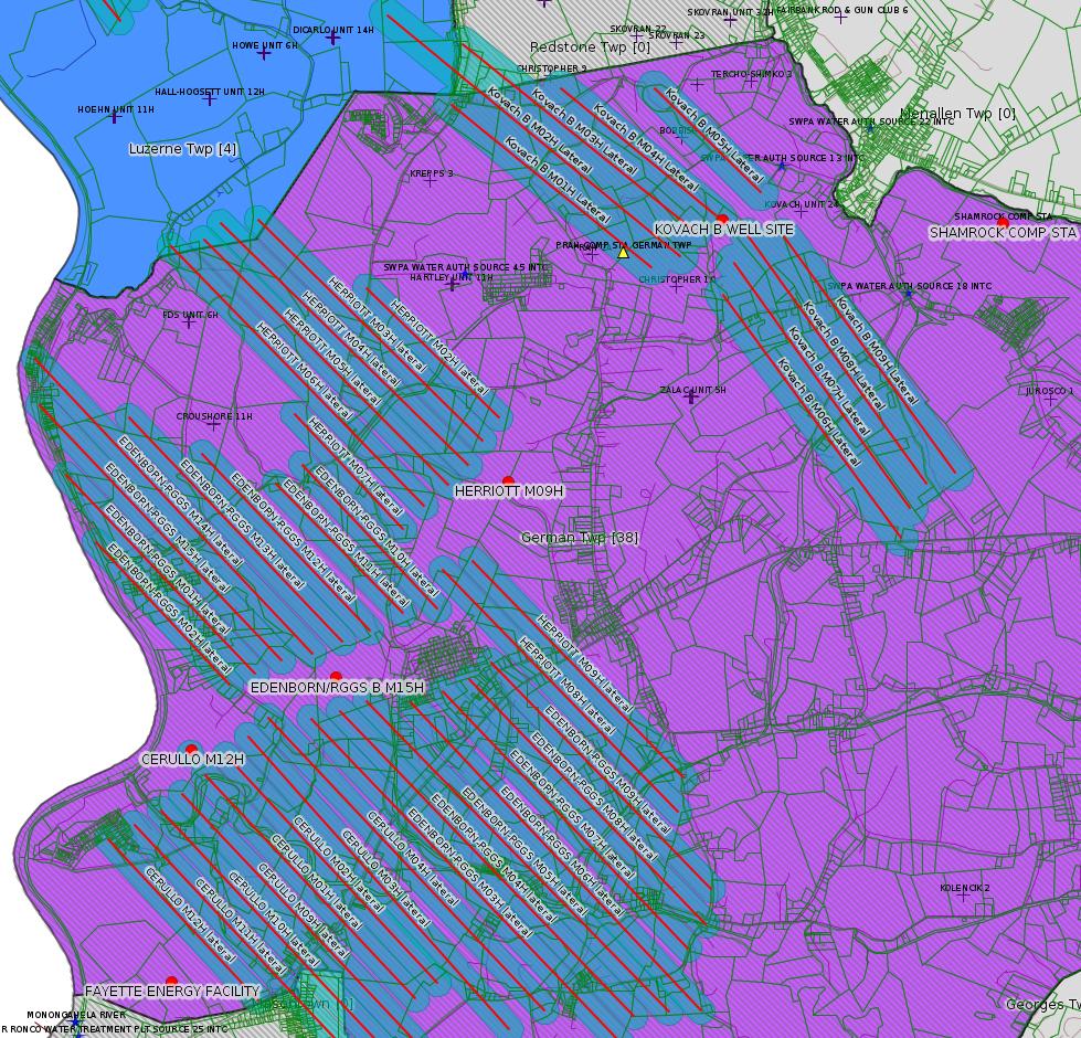
DEP Waste Reports show that the Ronco facility is the principal destination for frackwater from Chevron's Fayette County Marcellus Shale wells. Chevron has recently been in negotiation with German Twp landowners for easements for a frackwater pipeline from the Ronco facility to the recently permitted well pads in German Twp. (Herriott, Edenborn RGGS, Cerrulo, and Kovach B; for a map see <https://www.faymarwatch.org/happening/permits/map_focus1_031019.jpg> from the 3/10/19 issue of this bulletin).
---
There is a list of Jurisdictional Natural Gas Storage Fields (regulated by FERC) here:
<https://www.ferc.gov/sites/default/files/2020-05/Sortable.xlsx>
There is only one listed for Fayette County, Dominion's North Summit Field, which shows the following data in the spreadsheet linked above:
Company Name: Dominion Transmission, Inc.
Field Name: North Summit
Reservoir Name: Chert
Type: Depleted Field
Report State: PA
County: Fayette
AGA Region: East Region
Working Gas Capacity (Mcf): 11,500,000
Total Field Capacity (Mcf): 11,500,000
Maximum Daily Delivery (Mcf): 23,000,000
Status: Active
When industry advocates claim they have been fracking for decades, they are referring to stimulation of conventional wells, which normally occurred toward toward the end of the useful lifetime of a well. This is a far cry from today's fracking, which is both mandatory (no frack no gas) and up-front as a business capital cost.
That Dominion seeks to stimulate the North Summit storage field is interesting, suggesting perhaps that they are not receiving enough gas to keep the field going.
Note that the Comments in the stimulation notices refer to wells with different names than DEP attaches to the indicated permit numbers.
For the technically inclined: DCNR maintains a data set for Natural Gas Storage fields in its "Open Data Repository" here:
<http://www.gis.dcnr.state.pa.us/agsprod/rest/services/topo/Oil_n_Gas_Pool_Thematic/MapServer/9>
This is the source for the shaded area mapped above for the North Summit storage fields. Note that DEP records for wells with Storage Field "NORTH SUMMIT" (orange triangles) occur outside the area mapped by DCNR. It's not clear what methodology DCNR uses to map storage fields. (The Oakford field in Westmoreland County is one of the largest natural gas storage fields in the county, and also has storage wells DEP shows as part of the field outside the area mapped by DCNR.)
<https://earthjustice.org/sites/default/files/files/Fracking_Wastewater_Settlement.pdf>
DEP Waste Reports show that the Ronco facility is the principal destination for frackwater from Chevron's Fayette County Marcellus Shale wells. Chevron has recently been in negotiation with German Twp landowners for easements for a frackwater pipeline from the Ronco facility to the recently permitted well pads in German Twp. (Herriott, Edenborn RGGS, Cerrulo, and Kovach B; for a map see <https://www.faymarwatch.org/happening/permits/map_focus1_031019.jpg> from the 3/10/19 issue of this bulletin).
---
There is a list of Jurisdictional Natural Gas Storage Fields (regulated by FERC) here:
<https://www.ferc.gov/sites/default/files/2020-05/Sortable.xlsx>
There is only one listed for Fayette County, Dominion's North Summit Field, which shows the following data in the spreadsheet linked above:
Company Name: Dominion Transmission, Inc.
Field Name: North Summit
Reservoir Name: Chert
Type: Depleted Field
Report State: PA
County: Fayette
AGA Region: East Region
Working Gas Capacity (Mcf): 11,500,000
Total Field Capacity (Mcf): 11,500,000
Maximum Daily Delivery (Mcf): 23,000,000
Status: Active
When industry advocates claim they have been fracking for decades, they are referring to stimulation of conventional wells, which normally occurred toward toward the end of the useful lifetime of a well. This is a far cry from today's fracking, which is both mandatory (no frack no gas) and up-front as a business capital cost.
That Dominion seeks to stimulate the North Summit storage field is interesting, suggesting perhaps that they are not receiving enough gas to keep the field going.
Note that the Comments in the stimulation notices refer to wells with different names than DEP attaches to the indicated permit numbers.
For the technically inclined: DCNR maintains a data set for Natural Gas Storage fields in its "Open Data Repository" here:
<http://www.gis.dcnr.state.pa.us/agsprod/rest/services/topo/Oil_n_Gas_Pool_Thematic/MapServer/9>
This is the source for the shaded area mapped above for the North Summit storage fields. Note that DEP records for wells with Storage Field "NORTH SUMMIT" (orange triangles) occur outside the area mapped by DCNR. It's not clear what methodology DCNR uses to map storage fields. (The Oakford field in Westmoreland County is one of the largest natural gas storage fields in the county, and also has storage wells DEP shows as part of the field outside the area mapped by DCNR.)
------------------------
<https://www.dep.pa.gov/PublicParticipation/OfficeofEnvironmentalJustice/Pages/default.aspx>). There are supposed to be enhanced public participation requirements for permits in environmental justice areas, but news of this actually ever happening is scarce. In Fayette County, the entirety of Redstone, Springhill, Nicholson, and German Townships are environmental justice areas, as well as a large part of Dunbar Township. DEP's policy document on public participation guidelines for environmental justice areas is located here:
<https://www.elibrary.dep.state.pa.us/dsweb/Get/Version-48671/012-0501-002.pdf>
eNOTICE records are likely to list the same permit multiple times, as that permit moves through the DEP process.
Oil & Gas Wells designated with a site a number and the letter H typically designate horizontal wells.
-------------------------
Resources:
Pennsylvania Bulletin: <https://www.pabulletin.com/>
eNOTICE: <https://www.ahs2.dep.state.pa.
DEP Oil and Gas Reports: <https://www.dep.pa.gov/DataandTools/Reports/Oil%20and%20Gas%20Reports/Pages/default.aspx>
DEP Permits Issued Detail Report:
<http://cedatareporting.pa.gov/Reportserver/Pages/ReportViewer.aspx?/Public/DEP/OG/SSRS/Permits_Issued_Detail>
DEP SPUD (drilling started) Report:
<http://cedatareporting.pa.gov/Reportserver/Pages/ReportViewer.aspx?/Public/DEP/OG/SSRS/Spud_External_Data>
DEP Oil and Gas Compliance Report:
<http://cedatareporting.pa.gov/Reportserver/Pages/ReportViewer.aspx?/Public/DEP/OG/SSRS/OG_Compliance>
DEP PA Oil & Gas Mapping:
<https://www.depgis.state.pa.us/PaOilAndGasMapping>
Data Portal Services Directory [Technical]
<https://www.depgis.state.pa.us/arcgis/rest/services>
Query: Oil and Gas Wells All (ID: 3) [Technical]:
<https://www.depgis.state.pa.us/arcgis/rest/services/OilGas/OilGasAllStrayGasEGSP/MapServer/3/query?where=&text=&objectIds=&time=&geometry=&geometryType=esriGeometryEnvelope&inSR=&spatialRel=esriSpatialRelIntersects&relationParam=&outFields=*&returnGeometry=true&returnTrueCurves=false&maxAllowableOffset=&geometryPrecision=&outSR=&returnIdsOnly=false&returnCountOnly=false&orderByFields=&groupByFieldsForStatistics=&outStatistics=&returnZ=false&returnM=false&gdbVersion=&returnDistinctValues=false&resultOffset=&resultRecordCount=&f=html>
(Be sure to enter a Where clause in SQL format. Dates are in milliseconds since midnight 1/1/1970).
DEP Oil and Gas Electronic Submissions
<https://www.ahs.dep.pa.gov/eSubmissionPublicSearch>
DEP Air Quality Air Emission Plants Facilities Report
<http://cedatareporting.pa.gov/Reportserver/Pages/ReportViewer.aspx?/Public/DEP/AQ/SSRS/AQ_AEP_Facilities>
DEP Oil and Gas Electronic Notifications
<http://cedatareporting.pa.gov/Reportserver/Pages/ReportViewer.aspx?/Public/DEP/OG/SSRS/OG_Notifications>
DEP Oil and Gas Well Pad Report
<http://cedatareporting.pa.gov/Reportserver/Pages/ReportViewer.aspx?/Public/DEP/OG/SSRS/Well_Pads>
Fayette County Assessment Office Search For Tax Records:
<http://property.co.fayette.pa.us/search.aspx>
Pennsylvania Spatial Data Access:
<https://www.pasda.psu.edu/default.asp>
DEP Spatial Data Repository:
<ftp://www.pasda.psu.edu/pub/pasda/dep/>
National Response Center:
<https://www.nrc.uscg.mil/>
EPA-Echo: <https://www.epa-echo.gov/echo/
FERC citizen involvement: <https://www.ferc.gov/for-citiz
To receive E-mail notification of
all documents filed in a FERC docket, see:
<https://www.ferc.gov/docs-filing/esubscription.asp >
<https://www.ferc.gov/docs-fili
Follow the directions and enter the docket number to subscribe to.
Township Supervisors receive information regarding Erosion & Sedimentation permits, and these records may be reviewable at township municipal offices.
DEP permits are reviewable through the File Review process, for application to do file review see: <https://www.portal.state.pa.us/portal/server.pt/community/southwest_regional_office/13775/file_review/593164>
Environmental Hearing Board: <https://ehb.courtapps.com/publ
PA DEP Environmental Policy Comment System:
<https://www.ahs.dep.pa.gov/eComment/>
Federal Register Environment: <https://www.federalregister.g
Browsing of recent comment
opportunities for federal agencies, e.g. EPA. Click "sign up" to
subscribe to daily E-mails of new document listings.
SkyTruth Fayette County Drilling Alerts: <https://frack.skytruth.org/pen
U.S. Army Corps of Engineers, Pittsburgh District, Public Notices:
<https://www.lrp.usace.army.mil/Missions/Regulatory/Public-Notices/>
EPA Pennsylvania Public Notices: <https://www2.epa.gov/aboutepa/epa-pennsylvania#notice>
Marcellus Shale waste disposal
injection wells in Pennsylvania are regulated directly by EPA, not
DEP. Notice of any new permit applications will appear at the
above web address. I'm not aware of any subscription service
to be notified of such applications. I'm not aware of any
Marcellus Shale waste disposal injection wells in Fayette County
(yet ...) but we need to monitor this page for future
applications.
Energy Assurance Daily: <https://www.oe.netl.doe.gov/ead.aspx>
Daily newsletter from the US
Department of Energy about events relating to energy. The Natural
Gas section has information about pipelines.
-------------------------
Disclaimers:
This compilation from the above sources was done in part by hand using copy and paste and in part using automated methods; it may omit relevant permits.
Parcel data is provided via the tax records search web page offered by the Fayette County Assessment Office (http://property.co.fayette.pa.us/). Presumed Parcel Id links are subject to availability provided by that agency and associated web sites. Presumed Parcel Ids are determined as the mapped parcel containing a given latitude and longitude, are a best effort determination which is subject to error, and are not official. In cases where a facility is leased and there is a separate parcel id for the lease, if this parcel id is not separately mapped, the parcel id shown will be the id for the enclosing parcel. Parcel owners may be surface owners only and may or may not have any relationship to oil & gas facilities.
Does not currently include water supply permits. Does not include landfill permits even though many such are for Marcellus Shale waste. (It is not possible at this time to distinguish which landfill permits are for Marcellus Shale waste and which are not without doing File Review for each permit.)
Erosion & Sedimentation permit records do not currently include latitude and longitude. Where I am publishing latitude and longitude with E&S permits it is by inferring an associated well permit and using published latitude and longitude for the well. It is possible I may be inferring the wrong well site.
Municipalities are shown from eFACTS records on the DEP web site. The DEP has been known to list a municipality incorrectly.