The Harmed Success Stories Concepts How To What Is Commentary
Fayette County Marcellus Shale Permits 9/21/20 - 10/4/20
Contents
Pennsylvania Bulletin Listings
GOVERNOR'S OFFICE Regulatory AgendaeFACTS Listings
Residual Waste General Permit WMGR123; Base Permit Extension
YODER WELL PAD Expedited E&S Stormwater General Permit 1 [Termination?] Notification (New)Wells SPUD (Drilling Started)
CHESTNUT VALLEY LDFL Landfill Permit Form 37(per component)
(SARA GORLEY ML&HCO)A G MILLER EST 963 Well Plugging Notice Intent to Plug Single Well Issued 9/23/2020
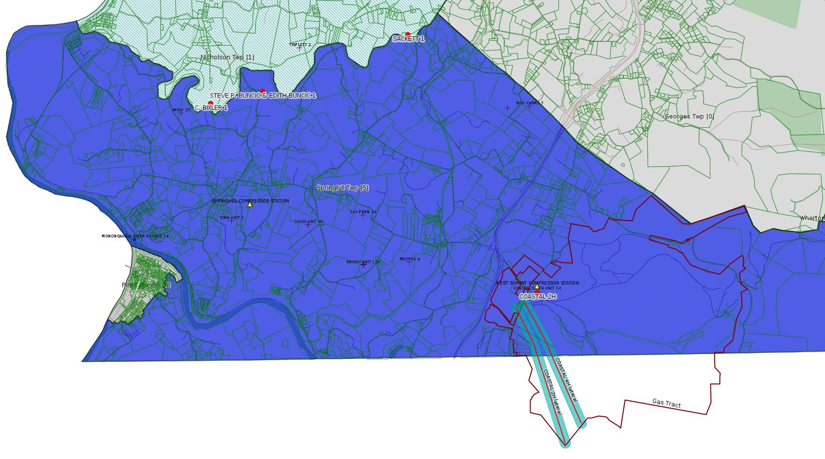
COASTAL 2H Drill & Operate Well Permit (Unconventional) Issued 9/22/2020
COASTAL 4H Drill & Operate Well Permit (Unconventional) Issued 9/22/2020
ENERGY RESOURCES LLC FAYETTE CNTY GP-04 Intake & Outfall Structures Issued 9/22/2020
CHESTNUT VALLEY LDFL Major Facility Operating Permit
COASTAL 2H 9/29/2020Inspection Issues
COASTAL 4H 9/29/2020
JACKSON FARMS UNIT 38H completion report was not located Violation(s) Noted 09/02/2020Inspection Issues -- Catch-up (2/1/20 - 8/31/20) [See Notes.]
JACKSON FARMS UNIT 39H completion report was not located Violation(s) Noted 09/10/2020
(SARA GORLEY ML&HCO)A G MILLER EST 963 obstructions in the wellbore; casing is in extremely corroded 09/11/2020
GRAHAM HEIRS 1 operator has not reported Production or MIA since 2017 Violation(s) Noted 09/15/2020
JACKSON FARMS UNIT 37H completion report was not located Violation(s) Noted 09/15/2020
CANIGIANI 2 Tank is heavily corroded and has been taken out of use Violation(s) Noted 09/24/2020
JOHN E DUNAY 4917 operator failed to erect a permanent well marker Violation(s) Noted 09/25/2020
STEVE P. BUNCIC & EDITH BUNCIC 1 No Annual Production or Mechanical Integrity Reports since 2016 Violation(s) Noted 10/02/2020
C. BIXLER 1 No Annual Production or Mechanical Integrity Reports Violation(s) Noted 10/02/2020
SACKETT 1 No Annual Production or Mechanical Integrity Reports since 2016 Violation(s) Noted 10/02/2020
OHLER/FORSYTHE 1 Equipment is heavily corroded 02/24/2020Price of Natural Gas
SOBERDASH COAL & COKE COMPANY 1 Equipment has moderate corrosion 02/26/2020
BRAZZON 15 Failure to deal with numerous violations 03/03/2020 Outstanding Violations - Viols Req'd
YASENOSKY 3 12/4/18 Violations not corrected 03/11/2020 Violation(s) & Outstanding Violations
BERTHA M & E G MUELLER 604557 Site Restoration Temporary BMPs still in place; access road has not been restored
SPROUL 7005 Well is being taken off inactive status by the Pa DEP Violation(s) Noted
MAWC 7020 3H Well is no longer approved for inactive status Violation(s) Noted
SPROUL 7005 Erosion issues, signage & document issues, etc. Violation(s) Noted
MAWC 7020 3H Numerous issues Violation(s) Noted
ARMSTRONG ET AL UNIT 1 Well label was missing from the wellhead and no marker present Violation(s) Noted
MOORE 11 Vehicle hit well & pipeline equipment, spilled material not properly cleaned up; Violation(s) Noted
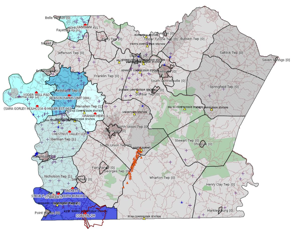
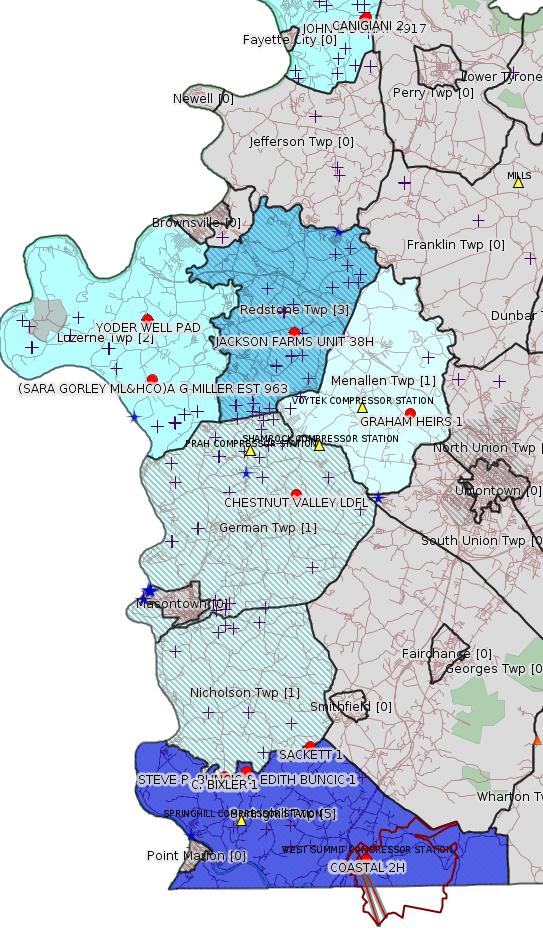
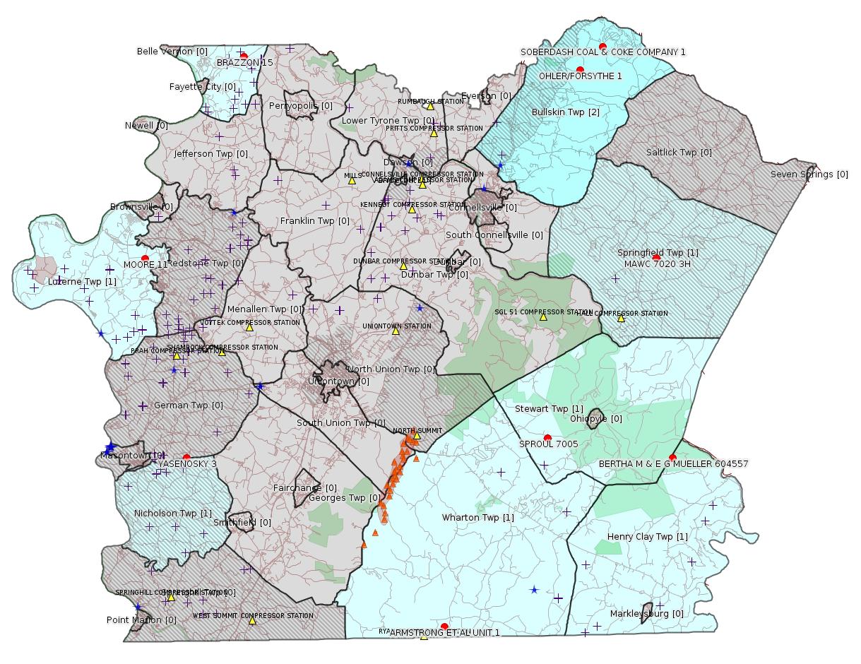
Map
Key
Red dots: items in this permit list with an exact location.
Blue stars: Marcellus Gas Well Water Sources.
Where well laterals are mapped they show in red; a 400-foot buffer surrounding the lateral shows in blue (lavender where it overlaps a mapped mineral tract).
Where mineral tracts are mapped, they show in pink. Mineral tracts can overlap; the overlap will show in red. The precise meaning of "mineral tract" is not clear.
Municipality shading: number of "facilities", with each well counting separately
(includes the red dots):
gray: 0
pale turquoise: 1
turquoise: 2
pale blue: 3
middle blue: 4
dark blue: 5
dark purple: 6
purple: 18
(Color coding may differ from one issue to the next.)
(Note if a project spans multiple municipalities -- e.g. a pipeline -- it will show in the count for each municipality.)
The number of facilities also follows the municipality name in brackets.
Municipality counts are based on the way the permit is listed by DEP; DEP has been known to get a municipality wrong.
Locations in brackets identify a precise location used to locate a surrogate for the actual site being permitted (e.g. locating a well pad or pipeline by the known location of a well.) Locations labeled beginning with "~" and ending in "[?]" are approximate and speculative based on inferences using on-line property and lease records. These are marked in the text as "[Approximate, Speculative]
Cross-hatching: Environmental Justice Areas
Yellow triangles: Compressor Stations
Orange triangles: Storage Field Wells (currently Dominion North Summit Storage Field)
Crosses: SPUD Unconventional well permits
Green: "Natural areas", e.g. state game lands, state forests
Yellow triangles: Compressor Stations
Orange triangles: Storage Field Wells (currently Dominion North Summit Storage Field)
Crosses: SPUD Unconventional well permits
Green: "Natural areas", e.g. state game lands, state forests
More Maps
 |
 |
 Inspection Catch-Up 2/1/20 - 8/31/20 [See Notes.] |
Source: Pennsylvania Bulletin
NOTICES
GOVERNOR'S OFFICE
Regulatory Agenda
[50 Pa.B. 5568]
[Saturday, October 3, 2020]
Executive Order 1996-1 requires all agencies under the jurisdiction of the Governor to submit for publication semi-annually an agenda of regulations under development or consideration.
The agendas are compiled to provide members of the regulated community advanced notice of regulatory activity. It is the intention of the Administration that these agendas will serve to increase public participation in the regulatory process.
Agency contacts should be contacted for more information regarding the regulation and the procedure for submitting comments.
This Agenda represents the Administration's present intentions regarding future regulations. The information provided is current as of September 21, 2020. The nature and complexity of an individual regulation obviously will determine whether and when any particular regulation listed (as well as any considered subsequent to publication of this Agenda) is published.
[Excerpt:]
| Regulation Being Considered | Proposed Date of Promulgation | Need and Legal Basis for Action | Agency Contact |
|---|---|---|---|
| Environmental Protection Performance Standards for
Conventional Oil and Gas Operators 25 Pa. Code Chapter 78 (# 7-539) |
Quarter 2, 2021, EQB Consideration, as Proposed |
This rulemaking proposes to amend the Oil and Gas regulations applicable to conventional operators (Chapter 78) to update the environmental protection performance standards related to oil and gas activities. (2012 Oil and Gas Act, Clean Streams Law, Solid Waste Management Act, Dam Safety Encroachment Act, Land Recycling and Environmental Remediation Standards Act, Radiation Protection Act, Unconventional Well Report Act, Act 126 of 2014) | Kurt Klapkowski (717) 772-2199 kklapkowsk@pa.gov |
| Waste Management and Related Issues at Conventional Oil
and Gas Well Sites 25 Pa. Code Chapter 78 (# 7-540) |
Quarter 2, 2021, EQB Consideration, as Proposed |
This proposed rulemaking relates primarily to the proper management of waste generated at conventional oil and gas well sites. The purpose of this regulation is to update the performance standards for surface activities at conventional well sites to ensure that these activities are conducted in a manner that protects the health, safety, and environment and property of Pennsylvania's residents. | Kurt Klapkowski (717) 772-2199 kklapkowsk@pa.gov |
| Control of VOC Emissions from Oil and Natural Gas Sources 25 Pa. Code Chapter 129 (# 7-544) |
Quarter 3, 2021, EQB Consideration, as Final |
This rulemaking proposes to establish emission limitations and other requirements codified in 25 Pa. Code Chapter 129 consistent with reasonably available control technology (RACT). The proposed rulemaking would establish RACT requirements for volatile organic compounds and other pollutants from existing oil and natural gas production facilities, compressor stations, processing plants, and transmission stations. Upon promulgation, the final-form regulation would be submitted to the EPA for approval as a SIP revision. (Air Pollution Control Act) | Susan Hoyle (717) 772-2329 shoyle@pa.gov |
---
NOTICES
DEPARTMENT OF
ENVIRONMENTAL PROTECTION
Residual Waste General Permit WMGR123; Base Permit Extension
[50 Pa.B. 5547]
[Saturday, October 3, 2020]
Under the authority of the Solid Waste Management Act (35 P.S. §§ 6018.101—6018.1003) and the Municipal Waste Planning, Recycling and Waste Reduction Act (53 P.S. §§ 4000.101—4000.1904), the Department of Environmental Protection (Department) by this notice issues a 3-month extension of the terms of its current General Permit No. WMGR123. The current General Permit No. WMGR1213 is scheduled to expire October 4, 2020. This General Permit authorizes permittees to process, transfer and beneficially use oil and gas liquid waste to develop or hydraulically fracture an oil or gas well.
The Department published notice of its intent to modify and renew General Permit No. WMGR123 (WMGR123) at 50 Pa.B. 2137 (April 18, 2020). The Department received significant public interest in the proposed modifications to WMGR123. Due to the volume and breadth of the comments received, WMGR123 will be renewed with its existing permit language for 3 months, until January 4, 2021. This will allow time for the Department to finalize responses to the comments received during the 60-day public comment period.
At this time, the Department will not take a final action on pending renewal applications under WMGR123 until the revised General Permit WMGR123 has been issued. Until the Department acts on the pending renewal applications, existing coverage under WMGR123 will automatically continue in accordance with the following general permit Condition C.19., provided permittees are in compliance with all other terms and conditions of WMGR123:
''In the event that a timely and complete application for renewal has been submitted and the Department is unable, through no fault of the permittee, to reissue the general permit or approval for coverage before its current coverage expiration date, the terms and conditions of the approved coverage will automatically continue and will remain fully effective and enforceable pending the issuance or denial of the renewal for permit coverage, provided the permittee is, and has been, operating in compliance with the terms and conditions of the general permit.''
The terms and conditions of WMGR123 remain fully effective and enforceable pending the Department's final action on the application for renewal of permit coverage.
Persons interested in reviewing the general permit may contact Chris Solloway at csolloway@pa.gov, (717) 787-7381, or Environmental Group Manager, Permits Section, Division of Municipal and Residual Waste, Bureau of Waste Management, P.O. Box 69170, Harrisburg, PA 17106-9170.
Persons in need of accommodations as provided for in the Americans with Disabilities Act of 1990 should contact Chris Solloway at (717) 787-7381 or through the Pennsylvania AT&T Relay Service at (800) 654-5984 (TDD users) or (800) 654-5988 (voice users) to discuss how the Department may accommodate their needs.
PATRICK McDONNELL,
Secretary
<http://www.pacodeandbulletin.gov/Display/pabull?file=/secure/pabulletin/data/vol50/50-40/1357.html>
-------------------------
Source: eNOTICE
(+ PA
Oil and Gas Mapping, Well
Pad Report.) Well Details via Data
Portal Services: Oil and Gas Wells All (ID: 3).
Please see the Disclaimer below regarding Parcel Id data.
Authorization ID: 1328735
Permit number: ESX15-051-0007
Site: YODER WELL PAD ESCGP-2 EXPEDITED
Client: CHEVRON APPALACHIA LLC
Authorization type: Expedited E&S Stormwater General Permit 1
Application type: Notification
Authorization is for: SITE
Date received: 09/30/2020
Status: Pending
Permit Decision Guarantee Applies?: No
Permit Review Notes:
Date Review Note
9/30/2020 The permit application package is complete, has been accepted, and is undergoing technical review.
<https://www.ahs.dep.pa.gov/eFACTSWeb/searchResults_singleAuth.aspx?AuthID=1328735>
Site Programs:
Oil & Gas
Site Municipalities:
Luzerne Twp, Fayette County
Well Pad Id: 153100
Location: 39.975683, -79.923763
Wells on this Pad:
Presumed Parcel Id: 19160034
---
Authorization ID: 1327102
Permit number: 100419
Site: CHESTNUT VALLEY LDFL
Client: ADVANCED DSPL SVC CHESTNUT VALLEY LDFL INC
Authorization type: Landfill Permit Form 37(per component)
Application type: Modification
Authorization is for: FACILITY
Date received: 09/11/2020
Status: Pending
Permit Decision Guarantee Applies?: Yes
Permit Decision Guarantee status: ACTIVE
Permit Review Notes:
Date Review Note
10/1/2020 The technical review and decision review are complete and either the permit decision and/or permit issuance are forthcoming.
9/11/2020 The permit application package is complete, has been accepted, and is undergoing technical review.
<https://www.ahs.dep.pa.gov/eFACTSWeb/searchResults_singleAuth.aspx?AuthID=1327102>
Site Programs:
Air Quality
Clean Water
Environmental Cleanup & Brownfields
Mining
Radiation Protection
Waste Management
Water Planning and Conservation
Site Municipalities:
German Twp, Fayette County
Authorization ID: 1326625
Permit number: 051-20054
Site: SARA GORLEY ML & HCO AG MILL 963 WELL
Client: FORTRESS ENERGY CORP
Authorization type: Well Plugging Notice Intent to Plug Single Well
Application type: New
Authorization is for: FACILITY
Date received: 09/09/2020
Status: Issued on 9/23/2020
Permit Decision Guarantee Applies?: No
Sub-Facilities for Authorization:
Sub-Facility ID Sub-Facility Name Description
1054667 (SARA GORLEY ML&HCO)A G MILLER EST 963 Well
56261 (SARA GORLEY ML&HCO)A G MILLER EST 963 Well
Permit Review Notes:
Date Review Note
9/23/2020 The technical review and decision review are complete and either the permit decision and/or permit issuance are forthcoming.
9/10/2020 The permit application package is complete, has been accepted, and is undergoing technical review.
<https://www.ahs.dep.pa.gov/eFACTSWeb/searchResults_singleAuth.aspx?AuthID=1326625>
Site Programs:
Oil & Gas
Site Municipalities:
Luzerne Twp, Fayette County
Well Details:
Permit Number: 051-20054
Well Name: (SARA GORLEY ML&HCO)A G MILLER EST 963
Unconventional Well: N
Well Configuration: Vertical Well
Well Type: GAS
Well Status: Active
Coal Association: Coal
Conservation Well: N
Primary Facility ID: 42731
Site ID: 40979
Site Name: SARA GORLEY ML & HCO AG MILL 963 WELL
Well Pad ID: 0
Well Pad Name:
Storage Field:
Operator: FORTRESS ENERGY CORP
Operator Number: OGO-34106
Permit Date: 1901-01-01
Permit Date Expires:
SPUD Date: 2004-03-09
Date Plugged:
UIC ID:
UIC Type:
Surface Elevation: 1120
County: Fayette
Municipality: Luzerne Twp
Location: 39.948663,-79.921789
Map URL: <http://www.openstreetmap.org/?mlat=39.948663&mlon=-79.921789#map=15/39.948663/-79.921789>
OG WELLS PERMIT DOCS:
2020-09-24: Final Permit Documents, Name: 051-20054 - Notice of Intent to Plug (for Authorization: 1326625):
<http://www.depgis.state.pa.us/pdfHandler/pdFHandler.ashx?Doc=MTQ2MjA0NA==&ext=PDF>
---
Authorization ID: 1322984
Permit number: 051-24722
Site: COASTAL 1H FLOW BACK PIT FRESHWATER PITS ESCGP-EXPEDITED
Client: INR OPR LLC
Authorization type: Drill & Operate Well Permit (Unconventional)
Application type: New
Authorization is for: FACILITY
Date received: 08/11/2020
Status: Issued on 9/22/2020
Permit Decision Guarantee Applies?: Yes
Permit Decision Guarantee status: VOID
Sub-Facilities for Authorization:
Sub-Facility ID Sub-Facility Name Description
1313193 WELLBORE SURFACE HOLE LOCATION Well
Permit Review Notes:
Date Review Note
8/27/2020 The technical review and decision review are complete and either the permit decision and/or permit issuance are forthcoming.
8/24/2020 Applicant has been issued a deficiency letter. If applicable, this application no longer qualifies for the Permit Decision Guarantee.
8/18/2020 Applicant has been issued a deficiency letter. If applicable, this application no longer qualifies for the Permit Decision Guarantee.
8/12/2020 The permit application package is complete, has been accepted, and is undergoing technical review.
<https://www.ahs.dep.pa.gov/eFACTSWeb/searchResults_singleAuth.aspx?AuthID=1322984>
Site Programs:
Oil & Gas
Site Municipalities:
Springhill Twp, Fayette County
Well Details:
Permit Number: 051-24722
Well Name: COASTAL 2H
Unconventional Well: Y
Well Configuration: Horizontal Well
Well Type: GAS
Well Status: Active
Coal Association: Coal
Conservation Well: N
Primary Facility ID: 843825
Site ID: 739525
Site Name: COASTAL 1H FLOW BACK PIT FRESHWATER PITS ESCGP-EXPEDITED
Well Pad ID: 147971
Well Pad Name: COASTAL WELL PAD
Storage Field:
Operator: INR OPR LLC
Operator Number: OGO-51036
Permit Date: 2020-09-22
Permit Date Expires: 2021-09-22
SPUD Date: 2020-09-29
Date Plugged:
UIC ID:
UIC Type:
Surface Elevation: 1127
County: Fayette
Municipality: Springhill Twp
Location: 39.73315,-79.800903
Map URL: <http://www.openstreetmap.org/?mlat=39.73315&mlon=-79.800903#map=15/39.73315/-79.800903>
OG WELLS PERMIT DOCS:
2020-09-22: Final Permit Documents, Name: Auth 1322984 051-24722 (for Authorization: 1322984):
<http://www.depgis.state.pa.us/pdfHandler/pdFHandler.ashx?Doc=MTQ1NTA4Mg==&ext=PDF>
2020-09-22: Other Permit Documents, Name: Coastal Wells Deficiency Email (for Authorization: 1322984):
<http://www.depgis.state.pa.us/pdfHandler/pdFHandler.ashx?Doc=MTQwNzgyOQ==&ext=PDF>
Electronically Submitted Records:
2020-09-22: Submission for Authorization 1322984
Interested Party Notification: Coastal 2H - Springhill Township - Interested Party Signed Receipt - 08.04.2020.pdf
<http://www.depgis.state.pa.us/eWellDocHandler/pdFHandler.ashx?Doc=MTI1MjgxNw==&ext=PDF>
Coordination of Well Location with Public Resources: INR OPERATING - COASTAL 2H - COORDINATION_OF_WELL_LOCATION_WITH_PUBLIC_RESOURCES.pdf
<http://www.depgis.state.pa.us/eWellDocHandler/pdFHandler.ashx?Doc=MTI2MTg1Mg==&ext=PDF>
Pennsylvania Natural Diversity Inventory Form: INR OPERATING - COASTAL 2H - PNDI INVENTORY 07.21.2020.pdf
<http://www.depgis.state.pa.us/eWellDocHandler/pdFHandler.ashx?Doc=MTI2MTg1Mw==&ext=PDF>
Pennsylvania Natural Diversity Inventory Support Document: INR OPERATING - COASTAL 2H - PNDI SUPPORT 07.21.2020.pdf
<http://www.depgis.state.pa.us/eWellDocHandler/pdFHandler.ashx?Doc=MTI2MTg1NQ==&ext=PDF>
Operator Ownership and Control Information: INR OPERATING - COASTAL 2H - OPERATOR_OWNERSHIP_AND_CONTROL_INFORMATION_FORM 07.21.2020.pdf
<http://www.depgis.state.pa.us/eWellDocHandler/pdFHandler.ashx?Doc=MTI2MTg1Ng==&ext=PDF>
Well Permit Application - Coal Module: INR OPERATING - COASTAL 2H - COAL STATUS REPORT 07.24.2020.pdf
<http://www.depgis.state.pa.us/eWellDocHandler/pdFHandler.ashx?Doc=MTI2MTg1OA==&ext=PDF>
Location Plat: INR OPERATING - COASTAL 2H - LOCATION PLAT 08.25.2020 DEP COMMENT REVISIONS.dwg
<http://www.depgis.state.pa.us/eWellDocHandler/pdFHandler.ashx?Doc=MTI2ODM2Nw==&ext=PDF>
Well Cross-Section Diagram: INR OPERATING - COASTAL 2H - WELL CROSS-SECTION DIAGRAM 08.25.2020 DEP COMMENT REVISIONS.pdf
<http://www.depgis.state.pa.us/eWellDocHandler/pdFHandler.ashx?Doc=MTI2ODM3Mw==&ext=PDF>
Location Plat: INR OPERATING - COASTAL 2H - LOCATION PLAT 08.25.2020 DEP COMMENT REVISIONS.dwg
<http://www.depgis.state.pa.us/eWellDocHandler/pdFHandler.ashx?Doc=MTI2ODM3OA==&ext=PDF>
Permit Application to Drill and Operate a Well: 1958801.pdf
<http://www.depgis.state.pa.us/eWellDocHandler/pdFHandler.ashx?Doc=MTI2ODM4MA==&ext=PDF>
---
Authorization ID: 1322978
Permit number: 051-24721
Site: COASTAL 1H FLOW BACK PIT FRESHWATER PITS ESCGP-EXPEDITED
Client: INR OPR LLC
Authorization type: Drill & Operate Well Permit (Unconventional)
Application type: New
Authorization is for: FACILITY
Date received: 08/11/2020
Status: Issued on 9/22/2020
Permit Decision Guarantee Applies?: Yes
Permit Decision Guarantee status: VOID
Sub-Facilities for Authorization:
Sub-Facility ID Sub-Facility Name Description
1313192 WELLBORE SURFACE HOLE LOCATION Well
Permit Review Notes:
Date Review Note
8/27/2020 The technical review and decision review are complete and either the permit decision and/or permit issuance are forthcoming.
8/24/2020 Applicant has been issued a deficiency letter. If applicable, this application no longer qualifies for the Permit Decision Guarantee.
8/18/2020 Applicant has been issued a deficiency letter. If applicable, this application no longer qualifies for the Permit Decision Guarantee.
8/12/2020 The permit application package is complete, has been accepted, and is undergoing technical review.
<https://www.ahs.dep.pa.gov/eFACTSWeb/searchResults_singleAuth.aspx?AuthID=1322978>
Site Programs:
Oil & Gas
Site Municipalities:
Springhill Twp, Fayette County
Well Details:
Permit Number: 051-24721
Well Name: COASTAL 4H
Unconventional Well: Y
Well Configuration: Horizontal Well
Well Type: GAS
Well Status: Active
Coal Association: Coal
Conservation Well: N
Primary Facility ID: 843824
Site ID: 739525
Site Name: COASTAL 1H FLOW BACK PIT FRESHWATER PITS ESCGP-EXPEDITED
Well Pad ID: 147971
Well Pad Name: COASTAL WELL PAD
Storage Field:
Operator: INR OPR LLC
Operator Number: OGO-51036
Permit Date: 2020-09-22
Permit Date Expires: 2021-09-22
SPUD Date: 2020-09-29
Date Plugged:
UIC ID:
UIC Type:
Surface Elevation: 1127
County: Fayette
Municipality: Springhill Twp
Location: 39.733181,-79.800869
Map URL: <http://www.openstreetmap.org/?mlat=39.733181&mlon=-79.800869#map=15/39.733181/-79.800869>
OG WELLS PERMIT DOCS:
2020-09-22: Final Permit Documents, Name: Auth 1322978 051-24721 (for Authorization: 1322978):
<http://www.depgis.state.pa.us/pdfHandler/pdFHandler.ashx?Doc=MTQ1NTA3OQ==&ext=PDF>
2020-09-22: Other Permit Documents, Name: Coastal Wells Deficiency Email (for Authorization: 1322978):
<http://www.depgis.state.pa.us/pdfHandler/pdFHandler.ashx?Doc=MTQwNzk4MQ==&ext=PDF>
Electronically Submitted Records:
2020-09-22: Submission for Authorization 1322978
Pennsylvania Natural Diversity Inventory Form: INR OPERATING - COASTAL 4H - PNDI INVENTORY 07.21.2020.pdf
<http://www.depgis.state.pa.us/eWellDocHandler/pdFHandler.ashx?Doc=MTIzMzcxOQ==&ext=PDF>
Pennsylvania Natural Diversity Inventory Support Document: INR OPERATING - COASTAL 4H - PNDI SUPPORT 07.21.2020.pdf
<http://www.depgis.state.pa.us/eWellDocHandler/pdFHandler.ashx?Doc=MTIzMzcyMQ==&ext=PDF>
Operator Ownership and Control Information: INR OPERATING - COASTAL 4H - OPERATOR_OWNERSHIP_AND_CONTROL_INFORMATION_FORM 07.21.2020.pdf
<http://www.depgis.state.pa.us/eWellDocHandler/pdFHandler.ashx?Doc=MTIzMzcyMg==&ext=PDF>
Coordination of Well Location with Public Resources: INR OPERATING - COASTAL 4H - COORDINATION_OF_WELL_LOCATION_WITH_PUBLIC_RESOURCES.pdf
<http://www.depgis.state.pa.us/eWellDocHandler/pdFHandler.ashx?Doc=MTIzNjcxMQ==&ext=PDF>
Well Permit Application - Coal Module: INR OPERATING - COASTAL 4H - COAL STATUS REPORT 07.24.2020.pdf
<http://www.depgis.state.pa.us/eWellDocHandler/pdFHandler.ashx?Doc=MTIzOTY5MA==&ext=PDF>
Interested Party Notification: Coastal 4H - Springhill Township - Interested Party Signed Receipt - 08.04.2020.pdf
<http://www.depgis.state.pa.us/eWellDocHandler/pdFHandler.ashx?Doc=MTI1MjgyNA==&ext=PDF>
Location Plat: INR OPERATING - COASTAL 4H - LOCATION PLAT 08.25.2020 DEP COMMENT REVISIONS.dwg
<http://www.depgis.state.pa.us/eWellDocHandler/pdFHandler.ashx?Doc=MTI2ODY2Mw==&ext=PDF>
Well Cross-Section Diagram: INR OPERATING - COASTAL 4H - WELL CROSS-SECTION DIAGRAM 08.25.2020 DEP COMMENT REVISIONS.pdf
<http://www.depgis.state.pa.us/eWellDocHandler/pdFHandler.ashx?Doc=MTI2ODY2NA==&ext=PDF>
Location Plat: INR OPERATING - COASTAL 4H - LOCATION PLAT 08.25.2020 DEP COMMENT REVISIONS.dwg
<http://www.depgis.state.pa.us/eWellDocHandler/pdFHandler.ashx?Doc=MTI2ODY2NQ==&ext=PDF>
Permit Application to Drill and Operate a Well: 2141432.pdf
<http://www.depgis.state.pa.us/eWellDocHandler/pdFHandler.ashx?Doc=MTI2ODY3MA==&ext=PDF>
---
Authorization ID: 1322848
Permit number: GP042607220-024
Site: ENERGY RESOURCES LLC FAYETTE CNTY
Client: ENERGY RESOURCES LLC
Authorization type: GP-04 Intake & Outfall Structures
Application type: New
Authorization is for: FACILITY
Date received: 08/07/2020
Status: Issued on 9/22/2020
Permit Decision Guarantee Applies?: No
Sub-Facilities for Authorization:
Sub-Facility ID Sub-Facility Name Description
1313162 GP042607220-024 WATER WITHDRAWAL Intake Structure
Permit Review Notes:
Date Review Note
9/22/2020 The technical review and decision review are complete and either the permit decision and/or permit issuance are forthcoming.
8/27/2020 Applicant has been issued a deficiency letter. If applicable, this application no longer qualifies for the Permit Decision Guarantee.
8/27/2020 The permit application package is complete, has been accepted, and is undergoing technical review.
<https://www.ahs.dep.pa.gov/eFACTSWeb/searchResults_singleAuth.aspx?AuthID=1322848>
Site Programs:
Water Planning and Conservation
Site Municipalities:
Springhill Twp, Fayette County
---
Authorization ID: 1309840
Permit number: 26-00402
Site: CHESTNUT VALLEY LDFL
Client: ADVANCED DSPL SVC CHESTNUT VALLEY LDFL INC
Authorization type: Major Facility Operating Permit
Application type: Amendment
Authorization is for: FACILITY
Date received: 01/27/2020
Status: Pending
Permit Decision Guarantee Applies?: No
Permit Review Notes:
Date Review Note
3/20/2020 Applicant has been issued a deficiency letter. If applicable, this application no longer qualifies for the Permit Decision Guarantee.
3/20/2020 Applicant has been issued a deficiency letter. If applicable, this application no longer qualifies for the Permit Decision Guarantee.
<https://www.ahs.dep.pa.gov/eFACTSWeb/searchResults_singleAuth.aspx?AuthID=1309840>
Site Programs:
Air Quality
Clean Water
Environmental Cleanup & Brownfields
Mining
Radiation Protection
Waste Management
Water Planning and Conservation
Site Municipalities:
German Twp, Fayette County
As shown above, SPUD date for Coastal 2H and Coastal 4H is 9/29/2020
-------------------------
Please see the Disclaimer below regarding Parcel Id data.
Authorization ID: 1328735
Permit number: ESX15-051-0007
Site: YODER WELL PAD ESCGP-2 EXPEDITED
Client: CHEVRON APPALACHIA LLC
Authorization type: Expedited E&S Stormwater General Permit 1
Application type: Notification
Authorization is for: SITE
Date received: 09/30/2020
Status: Pending
Permit Decision Guarantee Applies?: No
Permit Review Notes:
Date Review Note
9/30/2020 The permit application package is complete, has been accepted, and is undergoing technical review.
<https://www.ahs.dep.pa.gov/eFACTSWeb/searchResults_singleAuth.aspx?AuthID=1328735>
Site Programs:
Oil & Gas
Site Municipalities:
Luzerne Twp, Fayette County
Well Pad Id: 153100
Location: 39.975683, -79.923763
Wells on this Pad:
051-24652 YODER 1HPost Drill Restoration Report Yoder Pad A.pdf
051-24653 YODER 2H
051-24654 YODER 3H
051-24655 YODER 4H
051-24656 YODER 5H
051-24657 YODER 6H
051-24658 YODER 7H
051-24659 YODER 8H
051-24660 YODER 9H
051-24661 YODER 10H
051-24662 YODER 11H
051-24663 YODER 12H
Presumed Parcel Id: 19160034
---
Authorization ID: 1327102
Permit number: 100419
Site: CHESTNUT VALLEY LDFL
Client: ADVANCED DSPL SVC CHESTNUT VALLEY LDFL INC
Authorization type: Landfill Permit Form 37(per component)
Application type: Modification
Authorization is for: FACILITY
Date received: 09/11/2020
Status: Pending
Permit Decision Guarantee Applies?: Yes
Permit Decision Guarantee status: ACTIVE
Permit Review Notes:
Date Review Note
10/1/2020 The technical review and decision review are complete and either the permit decision and/or permit issuance are forthcoming.
9/11/2020 The permit application package is complete, has been accepted, and is undergoing technical review.
<https://www.ahs.dep.pa.gov/eFACTSWeb/searchResults_singleAuth.aspx?AuthID=1327102>
Site Programs:
Air Quality
Clean Water
Environmental Cleanup & Brownfields
Mining
Radiation Protection
Waste Management
Water Planning and Conservation
Site Municipalities:
German Twp, Fayette County
Location: 39.896749,-79.838809
Map URL: <http://www.openstreetmap.org/?mlat=39.896749&mlon=-79.838809#map=15/39.896749/-79.838809>
Presumed Parcel Id: 15280012
---Map URL: <http://www.openstreetmap.org/?mlat=39.896749&mlon=-79.838809#map=15/39.896749/-79.838809>
Presumed Parcel Id: 15280012
Authorization ID: 1326625
Permit number: 051-20054
Site: SARA GORLEY ML & HCO AG MILL 963 WELL
Client: FORTRESS ENERGY CORP
Authorization type: Well Plugging Notice Intent to Plug Single Well
Application type: New
Authorization is for: FACILITY
Date received: 09/09/2020
Status: Issued on 9/23/2020
Permit Decision Guarantee Applies?: No
Sub-Facilities for Authorization:
Sub-Facility ID Sub-Facility Name Description
1054667 (SARA GORLEY ML&HCO)A G MILLER EST 963 Well
56261 (SARA GORLEY ML&HCO)A G MILLER EST 963 Well
Permit Review Notes:
Date Review Note
9/23/2020 The technical review and decision review are complete and either the permit decision and/or permit issuance are forthcoming.
9/10/2020 The permit application package is complete, has been accepted, and is undergoing technical review.
<https://www.ahs.dep.pa.gov/eFACTSWeb/searchResults_singleAuth.aspx?AuthID=1326625>
Site Programs:
Oil & Gas
Site Municipalities:
Luzerne Twp, Fayette County
Well Details:
Permit Number: 051-20054
Well Name: (SARA GORLEY ML&HCO)A G MILLER EST 963
Unconventional Well: N
Well Configuration: Vertical Well
Well Type: GAS
Well Status: Active
Coal Association: Coal
Conservation Well: N
Primary Facility ID: 42731
Site ID: 40979
Site Name: SARA GORLEY ML & HCO AG MILL 963 WELL
Well Pad ID: 0
Well Pad Name:
Storage Field:
Operator: FORTRESS ENERGY CORP
Operator Number: OGO-34106
Permit Date: 1901-01-01
Permit Date Expires:
SPUD Date: 2004-03-09
Date Plugged:
UIC ID:
UIC Type:
Surface Elevation: 1120
County: Fayette
Municipality: Luzerne Twp
Location: 39.948663,-79.921789
Map URL: <http://www.openstreetmap.org/?mlat=39.948663&mlon=-79.921789#map=15/39.948663/-79.921789>
OG WELLS PERMIT DOCS:
2020-09-24: Final Permit Documents, Name: 051-20054 - Notice of Intent to Plug (for Authorization: 1326625):
<http://www.depgis.state.pa.us/pdfHandler/pdFHandler.ashx?Doc=MTQ2MjA0NA==&ext=PDF>
---
Authorization ID: 1322984
Permit number: 051-24722
Site: COASTAL 1H FLOW BACK PIT FRESHWATER PITS ESCGP-EXPEDITED
Client: INR OPR LLC
Authorization type: Drill & Operate Well Permit (Unconventional)
Application type: New
Authorization is for: FACILITY
Date received: 08/11/2020
Status: Issued on 9/22/2020
Permit Decision Guarantee Applies?: Yes
Permit Decision Guarantee status: VOID
Sub-Facilities for Authorization:
Sub-Facility ID Sub-Facility Name Description
1313193 WELLBORE SURFACE HOLE LOCATION Well
Permit Review Notes:
Date Review Note
8/27/2020 The technical review and decision review are complete and either the permit decision and/or permit issuance are forthcoming.
8/24/2020 Applicant has been issued a deficiency letter. If applicable, this application no longer qualifies for the Permit Decision Guarantee.
8/18/2020 Applicant has been issued a deficiency letter. If applicable, this application no longer qualifies for the Permit Decision Guarantee.
8/12/2020 The permit application package is complete, has been accepted, and is undergoing technical review.
<https://www.ahs.dep.pa.gov/eFACTSWeb/searchResults_singleAuth.aspx?AuthID=1322984>
Site Programs:
Oil & Gas
Site Municipalities:
Springhill Twp, Fayette County
Well Details:
Permit Number: 051-24722
Well Name: COASTAL 2H
Unconventional Well: Y
Well Configuration: Horizontal Well
Well Type: GAS
Well Status: Active
Coal Association: Coal
Conservation Well: N
Primary Facility ID: 843825
Site ID: 739525
Site Name: COASTAL 1H FLOW BACK PIT FRESHWATER PITS ESCGP-EXPEDITED
Well Pad ID: 147971
Well Pad Name: COASTAL WELL PAD
Storage Field:
Operator: INR OPR LLC
Operator Number: OGO-51036
Permit Date: 2020-09-22
Permit Date Expires: 2021-09-22
SPUD Date: 2020-09-29
Date Plugged:
UIC ID:
UIC Type:
Surface Elevation: 1127
County: Fayette
Municipality: Springhill Twp
Location: 39.73315,-79.800903
Map URL: <http://www.openstreetmap.org/?mlat=39.73315&mlon=-79.800903#map=15/39.73315/-79.800903>
OG WELLS PERMIT DOCS:
2020-09-22: Final Permit Documents, Name: Auth 1322984 051-24722 (for Authorization: 1322984):
<http://www.depgis.state.pa.us/pdfHandler/pdFHandler.ashx?Doc=MTQ1NTA4Mg==&ext=PDF>
2020-09-22: Other Permit Documents, Name: Coastal Wells Deficiency Email (for Authorization: 1322984):
<http://www.depgis.state.pa.us/pdfHandler/pdFHandler.ashx?Doc=MTQwNzgyOQ==&ext=PDF>
Electronically Submitted Records:
2020-09-22: Submission for Authorization 1322984
Interested Party Notification: Coastal 2H - Springhill Township - Interested Party Signed Receipt - 08.04.2020.pdf
<http://www.depgis.state.pa.us/eWellDocHandler/pdFHandler.ashx?Doc=MTI1MjgxNw==&ext=PDF>
Coordination of Well Location with Public Resources: INR OPERATING - COASTAL 2H - COORDINATION_OF_WELL_LOCATION_WITH_PUBLIC_RESOURCES.pdf
<http://www.depgis.state.pa.us/eWellDocHandler/pdFHandler.ashx?Doc=MTI2MTg1Mg==&ext=PDF>
Pennsylvania Natural Diversity Inventory Form: INR OPERATING - COASTAL 2H - PNDI INVENTORY 07.21.2020.pdf
<http://www.depgis.state.pa.us/eWellDocHandler/pdFHandler.ashx?Doc=MTI2MTg1Mw==&ext=PDF>
Pennsylvania Natural Diversity Inventory Support Document: INR OPERATING - COASTAL 2H - PNDI SUPPORT 07.21.2020.pdf
<http://www.depgis.state.pa.us/eWellDocHandler/pdFHandler.ashx?Doc=MTI2MTg1NQ==&ext=PDF>
Operator Ownership and Control Information: INR OPERATING - COASTAL 2H - OPERATOR_OWNERSHIP_AND_CONTROL_INFORMATION_FORM 07.21.2020.pdf
<http://www.depgis.state.pa.us/eWellDocHandler/pdFHandler.ashx?Doc=MTI2MTg1Ng==&ext=PDF>
Well Permit Application - Coal Module: INR OPERATING - COASTAL 2H - COAL STATUS REPORT 07.24.2020.pdf
<http://www.depgis.state.pa.us/eWellDocHandler/pdFHandler.ashx?Doc=MTI2MTg1OA==&ext=PDF>
Location Plat: INR OPERATING - COASTAL 2H - LOCATION PLAT 08.25.2020 DEP COMMENT REVISIONS.dwg
<http://www.depgis.state.pa.us/eWellDocHandler/pdFHandler.ashx?Doc=MTI2ODM2Nw==&ext=PDF>
Well Cross-Section Diagram: INR OPERATING - COASTAL 2H - WELL CROSS-SECTION DIAGRAM 08.25.2020 DEP COMMENT REVISIONS.pdf
<http://www.depgis.state.pa.us/eWellDocHandler/pdFHandler.ashx?Doc=MTI2ODM3Mw==&ext=PDF>
Location Plat: INR OPERATING - COASTAL 2H - LOCATION PLAT 08.25.2020 DEP COMMENT REVISIONS.dwg
<http://www.depgis.state.pa.us/eWellDocHandler/pdFHandler.ashx?Doc=MTI2ODM3OA==&ext=PDF>
Permit Application to Drill and Operate a Well: 1958801.pdf
<http://www.depgis.state.pa.us/eWellDocHandler/pdFHandler.ashx?Doc=MTI2ODM4MA==&ext=PDF>
---
Authorization ID: 1322978
Permit number: 051-24721
Site: COASTAL 1H FLOW BACK PIT FRESHWATER PITS ESCGP-EXPEDITED
Client: INR OPR LLC
Authorization type: Drill & Operate Well Permit (Unconventional)
Application type: New
Authorization is for: FACILITY
Date received: 08/11/2020
Status: Issued on 9/22/2020
Permit Decision Guarantee Applies?: Yes
Permit Decision Guarantee status: VOID
Sub-Facilities for Authorization:
Sub-Facility ID Sub-Facility Name Description
1313192 WELLBORE SURFACE HOLE LOCATION Well
Permit Review Notes:
Date Review Note
8/27/2020 The technical review and decision review are complete and either the permit decision and/or permit issuance are forthcoming.
8/24/2020 Applicant has been issued a deficiency letter. If applicable, this application no longer qualifies for the Permit Decision Guarantee.
8/18/2020 Applicant has been issued a deficiency letter. If applicable, this application no longer qualifies for the Permit Decision Guarantee.
8/12/2020 The permit application package is complete, has been accepted, and is undergoing technical review.
<https://www.ahs.dep.pa.gov/eFACTSWeb/searchResults_singleAuth.aspx?AuthID=1322978>
Site Programs:
Oil & Gas
Site Municipalities:
Springhill Twp, Fayette County
Well Details:
Permit Number: 051-24721
Well Name: COASTAL 4H
Unconventional Well: Y
Well Configuration: Horizontal Well
Well Type: GAS
Well Status: Active
Coal Association: Coal
Conservation Well: N
Primary Facility ID: 843824
Site ID: 739525
Site Name: COASTAL 1H FLOW BACK PIT FRESHWATER PITS ESCGP-EXPEDITED
Well Pad ID: 147971
Well Pad Name: COASTAL WELL PAD
Storage Field:
Operator: INR OPR LLC
Operator Number: OGO-51036
Permit Date: 2020-09-22
Permit Date Expires: 2021-09-22
SPUD Date: 2020-09-29
Date Plugged:
UIC ID:
UIC Type:
Surface Elevation: 1127
County: Fayette
Municipality: Springhill Twp
Location: 39.733181,-79.800869
Map URL: <http://www.openstreetmap.org/?mlat=39.733181&mlon=-79.800869#map=15/39.733181/-79.800869>
OG WELLS PERMIT DOCS:
2020-09-22: Final Permit Documents, Name: Auth 1322978 051-24721 (for Authorization: 1322978):
<http://www.depgis.state.pa.us/pdfHandler/pdFHandler.ashx?Doc=MTQ1NTA3OQ==&ext=PDF>
2020-09-22: Other Permit Documents, Name: Coastal Wells Deficiency Email (for Authorization: 1322978):
<http://www.depgis.state.pa.us/pdfHandler/pdFHandler.ashx?Doc=MTQwNzk4MQ==&ext=PDF>
Electronically Submitted Records:
2020-09-22: Submission for Authorization 1322978
Pennsylvania Natural Diversity Inventory Form: INR OPERATING - COASTAL 4H - PNDI INVENTORY 07.21.2020.pdf
<http://www.depgis.state.pa.us/eWellDocHandler/pdFHandler.ashx?Doc=MTIzMzcxOQ==&ext=PDF>
Pennsylvania Natural Diversity Inventory Support Document: INR OPERATING - COASTAL 4H - PNDI SUPPORT 07.21.2020.pdf
<http://www.depgis.state.pa.us/eWellDocHandler/pdFHandler.ashx?Doc=MTIzMzcyMQ==&ext=PDF>
Operator Ownership and Control Information: INR OPERATING - COASTAL 4H - OPERATOR_OWNERSHIP_AND_CONTROL_INFORMATION_FORM 07.21.2020.pdf
<http://www.depgis.state.pa.us/eWellDocHandler/pdFHandler.ashx?Doc=MTIzMzcyMg==&ext=PDF>
Coordination of Well Location with Public Resources: INR OPERATING - COASTAL 4H - COORDINATION_OF_WELL_LOCATION_WITH_PUBLIC_RESOURCES.pdf
<http://www.depgis.state.pa.us/eWellDocHandler/pdFHandler.ashx?Doc=MTIzNjcxMQ==&ext=PDF>
Well Permit Application - Coal Module: INR OPERATING - COASTAL 4H - COAL STATUS REPORT 07.24.2020.pdf
<http://www.depgis.state.pa.us/eWellDocHandler/pdFHandler.ashx?Doc=MTIzOTY5MA==&ext=PDF>
Interested Party Notification: Coastal 4H - Springhill Township - Interested Party Signed Receipt - 08.04.2020.pdf
<http://www.depgis.state.pa.us/eWellDocHandler/pdFHandler.ashx?Doc=MTI1MjgyNA==&ext=PDF>
Location Plat: INR OPERATING - COASTAL 4H - LOCATION PLAT 08.25.2020 DEP COMMENT REVISIONS.dwg
<http://www.depgis.state.pa.us/eWellDocHandler/pdFHandler.ashx?Doc=MTI2ODY2Mw==&ext=PDF>
Well Cross-Section Diagram: INR OPERATING - COASTAL 4H - WELL CROSS-SECTION DIAGRAM 08.25.2020 DEP COMMENT REVISIONS.pdf
<http://www.depgis.state.pa.us/eWellDocHandler/pdFHandler.ashx?Doc=MTI2ODY2NA==&ext=PDF>
Location Plat: INR OPERATING - COASTAL 4H - LOCATION PLAT 08.25.2020 DEP COMMENT REVISIONS.dwg
<http://www.depgis.state.pa.us/eWellDocHandler/pdFHandler.ashx?Doc=MTI2ODY2NQ==&ext=PDF>
Permit Application to Drill and Operate a Well: 2141432.pdf
<http://www.depgis.state.pa.us/eWellDocHandler/pdFHandler.ashx?Doc=MTI2ODY3MA==&ext=PDF>
---
Authorization ID: 1322848
Permit number: GP042607220-024
Site: ENERGY RESOURCES LLC FAYETTE CNTY
Client: ENERGY RESOURCES LLC
Authorization type: GP-04 Intake & Outfall Structures
Application type: New
Authorization is for: FACILITY
Date received: 08/07/2020
Status: Issued on 9/22/2020
Permit Decision Guarantee Applies?: No
Sub-Facilities for Authorization:
Sub-Facility ID Sub-Facility Name Description
1313162 GP042607220-024 WATER WITHDRAWAL Intake Structure
Permit Review Notes:
Date Review Note
9/22/2020 The technical review and decision review are complete and either the permit decision and/or permit issuance are forthcoming.
8/27/2020 Applicant has been issued a deficiency letter. If applicable, this application no longer qualifies for the Permit Decision Guarantee.
8/27/2020 The permit application package is complete, has been accepted, and is undergoing technical review.
<https://www.ahs.dep.pa.gov/eFACTSWeb/searchResults_singleAuth.aspx?AuthID=1322848>
Site Programs:
Water Planning and Conservation
Site Municipalities:
Springhill Twp, Fayette County
---
Authorization ID: 1309840
Permit number: 26-00402
Site: CHESTNUT VALLEY LDFL
Client: ADVANCED DSPL SVC CHESTNUT VALLEY LDFL INC
Authorization type: Major Facility Operating Permit
Application type: Amendment
Authorization is for: FACILITY
Date received: 01/27/2020
Status: Pending
Permit Decision Guarantee Applies?: No
Permit Review Notes:
Date Review Note
3/20/2020 Applicant has been issued a deficiency letter. If applicable, this application no longer qualifies for the Permit Decision Guarantee.
3/20/2020 Applicant has been issued a deficiency letter. If applicable, this application no longer qualifies for the Permit Decision Guarantee.
<https://www.ahs.dep.pa.gov/eFACTSWeb/searchResults_singleAuth.aspx?AuthID=1309840>
Site Programs:
Air Quality
Clean Water
Environmental Cleanup & Brownfields
Mining
Radiation Protection
Waste Management
Water Planning and Conservation
Site Municipalities:
German Twp, Fayette County
[See Notes.]
-------------------------
Inspection Issues Source: DEP Oil and Gas Compliance Report
OPERATOR: CHEVRON APPALACHIA LLC
INSPECTION_ID: 3075009
INSPECTION_DATE: 09/02/2020
INSPECTION_TYPE: Administrative/File Review
API_PERMIT: 051-24373
FARM_NAME: JACKSON FARMS UNIT 38H
UNCONVENTIONAL: Yes
SITE_ID: 720740
SITE_NAME: JACKSON FARMS 30 OG WELL
FACILITY_TYPE: Oil & Gas Location
INSPECTION_CATEGORY: Primary Facility
REGION: EP DOGO SWDO Dstr Off
COUNTY: Fayette
MUNICIPALITY: Redstone Twp
INSPECTOR: WOODS, MATTHEW
INSPECTION_SOURCE: SUBSAIR
INSPECTION_RESULT_DESCRIPTION: Violation(s) Noted
INSPECTION_COMMENT: An Administrative review was conducted and the completion report was not located.
VIOLATION_ID: 894462
VIOLATION_DATE: 09/02/2020
VIOLATION_CODE: OGA 3222(B3) - WELL REPORTING – COMPLETION REPORT – Operator failed to submit a completion report within 30 days after completion of the well.
VIOLATION_TYPE: Administrative
VIOLATION_COMMENT:
RESOLVED_DATE:
RESOLUTION_REASON_CODE_DESCRIPTION:
CONTINUING_VIOLATION:
ENFORCEMENT_ID: 388765
ENFORCEMENT_CODE_DESCRIPTION: NOV - Notice of Violation
DATE_EXECUTED: 09/21/2020
ENFORCEMENT_FINAL_DATE:
ENFORCEMENT_FINAL_STATUS:
PENALTY_FINAL_DATE:
PENALTY_FINAL_STATUS_CODE_DESCRIPTION:
PENALTY_AMOUNT:
TOTAL_AMOUNT_COLLECTED:
VIOLATION_ID: 894467
VIOLATION_DATE: 09/02/2020
VIOLATION_CODE: OGA3222(B.1) - WELL REPORTING – COMPLETION REPORT – Operator failed to submit a completion report containing all necessary information.
VIOLATION_TYPE: Administrative
VIOLATION_COMMENT:
RESOLVED_DATE:
RESOLUTION_REASON_CODE_DESCRIPTION:
CONTINUING_VIOLATION:
ENFORCEMENT_ID: 388765
ENFORCEMENT_CODE_DESCRIPTION: NOV - Notice of Violation
DATE_EXECUTED: 09/21/2020
ENFORCEMENT_FINAL_DATE:
ENFORCEMENT_FINAL_STATUS:
PENALTY_FINAL_DATE:
PENALTY_FINAL_STATUS_CODE_DESCRIPTION:
PENALTY_AMOUNT:
TOTAL_AMOUNT_COLLECTED:
Well Details:
Permit Number: 051-24373
Well Name: JACKSON FARMS UNIT 38H
Unconventional Well: Y
Well Configuration: Horizontal Well
Well Type: GAS
Well Status: Active
Coal Association: Coal
Conservation Well: Y
Primary Facility ID: 731832
Site ID: 720740
Site Name: JACKSON FARMS 30 OG WELL
Well Pad ID: 148606
Well Pad Name: JACKSON FARMS UNIT 37H
Storage Field:
Operator: CHEVRON APPALACHIA LLC
Operator Number: OGO-39307
Permit Date: 2010-07-08
Permit Date Expires: 2011-07-08
SPUD Date: 2010-08-11
Date Plugged:
UIC ID:
UIC Type:
Surface Elevation: 1210
County: Fayette
Municipality: Redstone Twp
Location: 39.969081,-79.838631
Map URL: <http://www.openstreetmap.org/?mlat=39.969081&mlon=-79.838631#map=15/39.969081/-79.838631>
Presumed Parcel Id: 30310028
---
OPERATOR: CHEVRON APPALACHIA LLC
INSPECTION_ID: 3080045
INSPECTION_DATE: 09/10/2020
INSPECTION_TYPE: Administrative/File Review
API_PERMIT: 051-24372
FARM_NAME: JACKSON FARMS UNIT 39H
UNCONVENTIONAL: Yes
SITE_ID: 720740
SITE_NAME: JACKSON FARMS 30 OG WELL
FACILITY_TYPE: Oil & Gas Location
INSPECTION_CATEGORY: Primary Facility
REGION: EP DOGO SWDO Dstr Off
COUNTY: Fayette
MUNICIPALITY: Redstone Twp
INSPECTOR: WOODS, MATTHEW
INSPECTION_SOURCE: SUBSAIR
INSPECTION_RESULT_DESCRIPTION: Violation(s) Noted
INSPECTION_COMMENT: An administrative review was conducted and the completion report was not located.
VIOLATION_ID: 894467
VIOLATION_DATE: 09/02/2020
VIOLATION_CODE: OGA3222(B.1) - WELL REPORTING – COMPLETION REPORT – Operator failed to submit a completion report containing all necessary information.
VIOLATION_TYPE: Administrative
VIOLATION_COMMENT:
RESOLVED_DATE:
RESOLUTION_REASON_CODE_DESCRIPTION:
CONTINUING_VIOLATION:
ENFORCEMENT_ID: 388765
ENFORCEMENT_CODE_DESCRIPTION: NOV - Notice of Violation
DATE_EXECUTED: 09/21/2020
ENFORCEMENT_FINAL_DATE:
ENFORCEMENT_FINAL_STATUS:
PENALTY_FINAL_DATE:
PENALTY_FINAL_STATUS_CODE_DESCRIPTION:
PENALTY_AMOUNT:
TOTAL_AMOUNT_COLLECTED:
VIOLATION_ID: 894466
VIOLATION_DATE: 09/02/2020
VIOLATION_CODE: OGA 3222(B3) - WELL REPORTING – COMPLETION REPORT – Operator failed to submit a completion report within 30 days after completion of the well.
VIOLATION_TYPE: Administrative
VIOLATION_COMMENT:
RESOLVED_DATE:
RESOLUTION_REASON_CODE_DESCRIPTION:
CONTINUING_VIOLATION:
ENFORCEMENT_ID: 388765
ENFORCEMENT_CODE_DESCRIPTION: NOV - Notice of Violation
DATE_EXECUTED: 09/21/2020
ENFORCEMENT_FINAL_DATE:
ENFORCEMENT_FINAL_STATUS:
PENALTY_FINAL_DATE:
PENALTY_FINAL_STATUS_CODE_DESCRIPTION:
PENALTY_AMOUNT:
TOTAL_AMOUNT_COLLECTED:
Well Details:
Permit Number: 051-24372
Well Name: JACKSON FARMS UNIT 39H
Unconventional Well: Y
Well Configuration: Horizontal Well
Well Type: GAS
Well Status: Active
Coal Association: Coal
Conservation Well: Y
Primary Facility ID: 731843
Site ID: 720740
Site Name: JACKSON FARMS 30 OG WELL
Well Pad ID: 148606
Well Pad Name: JACKSON FARMS UNIT 37H
Storage Field:
Operator: CHEVRON APPALACHIA LLC
Operator Number: OGO-39307
Permit Date: 2010-07-08
Permit Date Expires: 2011-07-08
SPUD Date: 2010-08-12
Date Plugged:
UIC ID:
UIC Type:
Surface Elevation: 1210
County: Fayette
Municipality: Redstone Twp
Location: 39.969081,-79.838603
Map URL: <http://www.openstreetmap.org/?mlat=39.969081&mlon=-79.838603#map=15/39.969081/-79.838603>
---
OPERATOR: FORTRESS ENERGY CORP
INSPECTION_ID: 3079706
INSPECTION_DATE: 09/11/2020
INSPECTION_TYPE: Routine/Complete Inspection
API_PERMIT: 051-20054
FARM_NAME: (SARA GORLEY ML&HCO)A G MILLER EST 963
UNCONVENTIONAL: No
SITE_ID: 40979
SITE_NAME: SARA GORLEY ML & HCO AG MILL 963 WELL
FACILITY_TYPE: Oil & Gas Location
INSPECTION_CATEGORY: Primary Facility
REGION: EP DOGO SWDO Dstr Off
COUNTY: Fayette
MUNICIPALITY: Luzerne Twp
INSPECTOR: WOODS, MATTHEW
INSPECTION_SOURCE: SUBSAIR
INSPECTION_RESULT_DESCRIPTION: No Violations Noted
INSPECTION_COMMENT: "On 9/11/20 OGI Matt Woods conducted an inspection of the well with plugging crew on site. At the time the crew was unable to get below 200' inside the 4"" casing due to obstructions in the wellbore. Crew was performing a camera run in an attempt to see the obstruction. Crew was unable see what was in the well. The casing is in extremely corroded. The crew has only been able to pull 8' of the four inch out of the hole. The crew plans to continue working on pulling the 4"" to reach BOH.
The well has five strings of casing, all on wall hangers without cement behind them."
Well Details above
---
OPERATOR: THE PRODUCTION CO LLC
INSPECTION_ID: 3080012
INSPECTION_DATE: 09/15/2020
INSPECTION_TYPE: Routine/Complete Inspection
API_PERMIT: 051-20807
FARM_NAME: GRAHAM HEIRS 1
UNCONVENTIONAL: No
SITE_ID: 41702
SITE_NAME: GRAHAM HEIRS 1 WELL
FACILITY_TYPE: Oil & Gas Location
INSPECTION_CATEGORY: Primary Facility
REGION: EP DOGO SWDO Dstr Off
COUNTY: Fayette
MUNICIPALITY: Menallen Twp
INSPECTOR: WOODS, MATTHEW
INSPECTION_SOURCE: SUBSAIR
INSPECTION_RESULT_DESCRIPTION: Violation(s) Noted
INSPECTION_COMMENT: "I have reviewed Production Reports and MIA reporting, the operator has not reported Production or MIA since 2017.
Follow up on a CTS. No issues found at site."
VIOLATION_ID: 894157
VIOLATION_DATE: 08/28/2020
VIOLATION_CODE: 78.121(A) - WELL REPORTING – PRODUCTION REPORTING – Conventional operator failed to submit annual conventional production and status report for permitted or registered well.
VIOLATION_TYPE: Administrative
VIOLATION_COMMENT:
RESOLVED_DATE:
RESOLUTION_REASON_CODE_DESCRIPTION:
CONTINUING_VIOLATION:
ENFORCEMENT_ID:
ENFORCEMENT_CODE_DESCRIPTION:
DATE_EXECUTED:
ENFORCEMENT_FINAL_DATE:
ENFORCEMENT_FINAL_STATUS:
PENALTY_FINAL_DATE:
PENALTY_FINAL_STATUS_CODE_DESCRIPTION:
PENALTY_AMOUNT:
TOTAL_AMOUNT_COLLECTED:
VIOLATION_ID: 894156
VIOLATION_DATE: 08/28/2020
VIOLATION_CODE: 78a88(a) - OPERATING WELLS - MECHANICAL INTEGRITY OF OPERATING WELLS - Operator failed to inspect each operating well quarterly for compliance with the well construction and operating requirements.
VIOLATION_TYPE: Environmental Health & Safety
VIOLATION_COMMENT:
RESOLVED_DATE:
RESOLUTION_REASON_CODE_DESCRIPTION:
CONTINUING_VIOLATION:
ENFORCEMENT_ID:
ENFORCEMENT_CODE_DESCRIPTION:
DATE_EXECUTED:
ENFORCEMENT_FINAL_DATE:
ENFORCEMENT_FINAL_STATUS:
PENALTY_FINAL_DATE:
PENALTY_FINAL_STATUS_CODE_DESCRIPTION:
PENALTY_AMOUNT:
TOTAL_AMOUNT_COLLECTED:
Well Details:
Permit Number: 051-20807
Well Name: GRAHAM HEIRS 1
Unconventional Well: N
Well Configuration: Vertical Well
Well Type: GAS
Well Status: Active
Coal Association: Coal
Conservation Well: N
Primary Facility ID: 43454
Site ID: 41702
Site Name: GRAHAM HEIRS 1 WELL
Well Pad ID: 0
Well Pad Name:
Storage Field:
Operator: THE PRODUCTION CO LLC
Operator Number: OGO-39567
Permit Date: 1996-02-21
Permit Date Expires: 1997-02-21
SPUD Date: 1996-03-05
Date Plugged:
UIC ID:
UIC Type:
Surface Elevation: 1213
County: Fayette
Municipality: Menallen Twp
Location: 39.93228,-79.771876
Map URL: <http://www.openstreetmap.org/?mlat=39.93228&mlon=-79.771876#map=15/39.93228/-79.771876>
Presumed Parcel Id: 2217006301
---
OPERATOR: CHEVRON APPALACHIA LLC
INSPECTION_ID: 3080049
INSPECTION_DATE: 09/15/2020
INSPECTION_TYPE: Administrative/File Review
API_PERMIT: 051-24369
FARM_NAME: JACKSON FARMS UNIT 37H
UNCONVENTIONAL: Yes
SITE_ID: 720740
SITE_NAME: JACKSON FARMS 30 OG WELL
FACILITY_TYPE: Oil & Gas Location
INSPECTION_CATEGORY: Primary Facility
REGION: EP DOGO SWDO Dstr Off
COUNTY: Fayette
MUNICIPALITY: Redstone Twp
INSPECTOR: WOODS, MATTHEW
INSPECTION_SOURCE: SUBSAIR
INSPECTION_RESULT_DESCRIPTION: Violation(s) Noted
INSPECTION_COMMENT: An administrative review was conducted and the completion report was not located.
VIOLATION_ID: 894469
VIOLATION_DATE: 09/02/2020
VIOLATION_CODE: OGA3222(B.1) - WELL REPORTING – COMPLETION REPORT – Operator failed to submit a completion report containing all necessary information.
VIOLATION_TYPE: Administrative
VIOLATION_COMMENT:
RESOLVED_DATE:
RESOLUTION_REASON_CODE_DESCRIPTION:
CONTINUING_VIOLATION:
ENFORCEMENT_ID: 388765
ENFORCEMENT_CODE_DESCRIPTION: NOV - Notice of Violation
DATE_EXECUTED: 09/21/2020
ENFORCEMENT_FINAL_DATE:
ENFORCEMENT_FINAL_STATUS:
PENALTY_FINAL_DATE:
PENALTY_FINAL_STATUS_CODE_DESCRIPTION:
PENALTY_AMOUNT:
TOTAL_AMOUNT_COLLECTED:
VIOLATION_ID: 894468
VIOLATION_DATE: 09/02/2020
VIOLATION_CODE: OGA 3222(B3) - WELL REPORTING – COMPLETION REPORT – Operator failed to submit a completion report within 30 days after completion of the well.
VIOLATION_TYPE: Administrative
VIOLATION_COMMENT:
RESOLVED_DATE:
RESOLUTION_REASON_CODE_DESCRIPTION:
CONTINUING_VIOLATION:
ENFORCEMENT_ID: 388765
ENFORCEMENT_CODE_DESCRIPTION: NOV - Notice of Violation
DATE_EXECUTED: 09/21/2020
ENFORCEMENT_FINAL_DATE:
ENFORCEMENT_FINAL_STATUS:
PENALTY_FINAL_DATE:
PENALTY_FINAL_STATUS_CODE_DESCRIPTION:
PENALTY_AMOUNT:
TOTAL_AMOUNT_COLLECTED:
Well Details:
Permit Number: 051-24369
Well Name: JACKSON FARMS UNIT 37H
Unconventional Well: Y
Well Configuration: Horizontal Well
Well Type: GAS
Well Status: Active
Coal Association: Coal
Conservation Well: Y
Primary Facility ID: 731806
Site ID: 720740
Site Name: JACKSON FARMS 30 OG WELL
Well Pad ID: 148606
Well Pad Name: JACKSON FARMS UNIT 37H
Storage Field:
Operator: CHEVRON APPALACHIA LLC
Operator Number: OGO-39307
Permit Date: 2010-06-30
Permit Date Expires: 2011-06-30
SPUD Date: 2010-08-05
Date Plugged:
UIC ID:
UIC Type:
Surface Elevation: 1210
County: Fayette
Municipality: Redstone Twp
Location: 39.969078,-79.838689
Map URL: <http://www.openstreetmap.org/?mlat=39.969078&mlon=-79.838689#map=15/39.969078/-79.838689>
---
OPERATOR: DIVERSIFIED OIL & GAS LLC
INSPECTION_ID: 3087486
INSPECTION_DATE: 09/24/2020
INSPECTION_TYPE: Routine/Complete Inspection
API_PERMIT: 051-22966
FARM_NAME: CANIGIANI 2
UNCONVENTIONAL: No
SITE_ID: 660402
SITE_NAME: CANIGIANI 2 OG WELL
FACILITY_TYPE: Oil & Gas Location
INSPECTION_CATEGORY: Primary Facility
REGION: EP DOGO SWDO Dstr Off
COUNTY: Fayette
MUNICIPALITY: Washington Twp
INSPECTOR: WOODS, MATTHEW
INSPECTION_SOURCE: SUBSAIR
INSPECTION_RESULT_DESCRIPTION: Violation(s) Noted
INSPECTION_COMMENT: "Well is in production.
MIA and APR up to date.
Tank is heavily corroded and has been taken out if use.
Violation 78.56(a) was written to address tank."
VIOLATION_ID: 896155
VIOLATION_DATE: 09/24/2020
VIOLATION_CODE: 78.56(a)3 - PITS AND TANKS FOR TEMPORARY CONTAINMENT - Operator failed to design, construct and maintain pits or tanks to be structurally sound.
VIOLATION_TYPE: Environmental Health & Safety
VIOLATION_COMMENT:
RESOLVED_DATE:
RESOLUTION_REASON_CODE_DESCRIPTION:
CONTINUING_VIOLATION:
ENFORCEMENT_ID:
ENFORCEMENT_CODE_DESCRIPTION:
DATE_EXECUTED:
ENFORCEMENT_FINAL_DATE:
ENFORCEMENT_FINAL_STATUS:
PENALTY_FINAL_DATE:
PENALTY_FINAL_STATUS_CODE_DESCRIPTION:
PENALTY_AMOUNT:
TOTAL_AMOUNT_COLLECTED:
Well Details:
Permit Number: 051-22966
Well Name: CANIGIANI 2
Unconventional Well: N
Well Configuration: Vertical Well
Well Type: GAS
Well Status: Active
Coal Association: Coal
Conservation Well: N
Primary Facility ID: 671685
Site ID: 660402
Site Name: CANIGIANI 2 OG WELL
Well Pad ID: 0
Well Pad Name:
Storage Field:
Operator: DIVERSIFIED OIL & GAS LLC
Operator Number: OGO-68792
Permit Date: 2005-09-23
Permit Date Expires: 2007-09-23
SPUD Date: 2007-09-20
Date Plugged:
UIC ID:
UIC Type:
Surface Elevation: 1010
County: Fayette
Municipality: Washington Twp
Location: 40.109666,-79.79409
Map URL: <http://www.openstreetmap.org/?mlat=40.109666&mlon=-79.79409#map=15/40.109666/-79.79409>
Presumed Parcel Id: 4119001701
---
OPERATOR: CAMPBELL DALE H
INSPECTION_ID: 3084526
INSPECTION_DATE: 09/25/2020
INSPECTION_TYPE: Follow-up Inspection
API_PERMIT: 051-20150
FARM_NAME: JOHN E DUNAY 4917
UNCONVENTIONAL: No
SITE_ID: 41048
SITE_NAME: JOHN E DUNAY 4917 WELL
FACILITY_TYPE: Oil & Gas Location
INSPECTION_CATEGORY: Primary Facility
REGION: EP DOGO SWDO Dstr Off
COUNTY: Fayette
MUNICIPALITY: Washington Twp
INSPECTOR: WOODS, MATTHEW
INSPECTION_SOURCE: SUBSAIR
INSPECTION_RESULT_DESCRIPTION: Violation(s) Noted
INSPECTION_COMMENT: "Area has been completely restored.
Well does not have a marker of any kind. After plugging of the well operator failed to erect a permanent well marker."
VIOLATION_ID: 895739
VIOLATION_DATE: 09/24/2020
VIOLATION_CODE: 78.96 - PLUGGING – MARKING THE LOCATION OF A PLUGGED WELL – Upon completion of plugging or replugging a well, the operator failed to erect a permanent marker with permit or registration number.
VIOLATION_TYPE: Environmental Health & Safety
VIOLATION_COMMENT:
RESOLVED_DATE:
RESOLUTION_REASON_CODE_DESCRIPTION:
CONTINUING_VIOLATION:
ENFORCEMENT_ID:
ENFORCEMENT_CODE_DESCRIPTION:
DATE_EXECUTED:
ENFORCEMENT_FINAL_DATE:
ENFORCEMENT_FINAL_STATUS:
PENALTY_FINAL_DATE:
PENALTY_FINAL_STATUS_CODE_DESCRIPTION:
PENALTY_AMOUNT:
TOTAL_AMOUNT_COLLECTED:
Well Details:
Permit Number: 051-20150
Well Name: JOHN E DUNAY 4917
Unconventional Well: N
Well Configuration: Vertical Well
Well Type: GAS
Well Status: Plugged OG Well
Coal Association: Coal
Conservation Well: N
Primary Facility ID: 42800
Site ID: 41048
Site Name: JOHN E DUNAY 4917 WELL
Well Pad ID: 0
Well Pad Name:
Storage Field:
Operator: CAMPBELL DALE H
Operator Number: OGO-10597
Permit Date: 1974-08-22
Permit Date Expires:
SPUD Date: 1974-09-18
Date Plugged: 1975-03-03
UIC ID:
UIC Type:
Surface Elevation: 0
County: Fayette
Municipality: Washington Twp
Location: 40.10875,-79.795688
Map URL: <http://www.openstreetmap.org/?mlat=40.10875&mlon=-79.795688#map=15/40.10875/-79.795688>
Presumed Parcel Id: 4119001701
---
OPERATOR: THE PRODUCTION CO LLC
INSPECTION_ID: 3088831
INSPECTION_DATE: 10/02/2020
INSPECTION_TYPE: Routine/Complete Inspection
API_PERMIT: 051-20810
FARM_NAME: STEVE P. BUNCIC & EDITH BUNCIC 1
UNCONVENTIONAL: No
SITE_ID: 41705
SITE_NAME: EDITH & STEVE P BUNCIC 1 WELL
FACILITY_TYPE: Oil & Gas Location
INSPECTION_CATEGORY: Primary Facility
REGION: EP DOGO SWDO Dstr Off
COUNTY: Fayette
MUNICIPALITY: Springhill Twp
INSPECTOR: WOODS, MATTHEW
INSPECTION_SOURCE: SUBSAIR
INSPECTION_RESULT_DESCRIPTION: Violation(s) Noted
INSPECTION_COMMENT: "No well label or marker.
Operator has not submitted an MIA or APR since 2016."
VIOLATION_ID: 896161
VIOLATION_DATE: 10/02/2020
VIOLATION_CODE: 78.121(A) - WELL REPORTING – PRODUCTION REPORTING – Conventional operator failed to submit annual conventional production and status report for permitted or registered well.
VIOLATION_TYPE: Administrative
VIOLATION_COMMENT:
RESOLVED_DATE:
RESOLUTION_REASON_CODE_DESCRIPTION:
CONTINUING_VIOLATION:
ENFORCEMENT_ID:
ENFORCEMENT_CODE_DESCRIPTION:
DATE_EXECUTED:
ENFORCEMENT_FINAL_DATE:
ENFORCEMENT_FINAL_STATUS:
PENALTY_FINAL_DATE:
PENALTY_FINAL_STATUS_CODE_DESCRIPTION:
PENALTY_AMOUNT:
TOTAL_AMOUNT_COLLECTED:
VIOLATION_ID 896160
VIOLATION_DATE 10/02/2020
VIOLATION_CODE 78.88(e) - OPERATING WELLS - MECHANICAL INTEGRITY OF OPERATING WELLS - Operator failed to submit an annual report to the Department identifying the compliance status of each well with the mechanical integrity requirements for structurally sound wells in compliance with 25 Pa. Code Section 78.73(c).
VIOLATION_TYPE Administrative
VIOLATION_COMMENT
RESOLVED_DATE
RESOLUTION_REASON_CODE_DESCRIPTION
CONTINUING_VIOLATION
ENFORCEMENT_ID
ENFORCEMENT_CODE_DESCRIPTION
DATE_EXECUTED
ENFORCEMENT_FINAL_DATE
ENFORCEMENT_FINAL_STATUS
PENALTY_FINAL_DATE
PENALTY_FINAL_STATUS_CODE_DESCRIPTION
PENALTY_AMOUNT
TOTAL_AMOUNT_COLLECTED
VIOLATION_ID: 896159
VIOLATION_DATE: 10/02/2020
VIOLATION_CODE: OGA3211(H) - WELL PERMITS - LABELING - Failure to install, in a permanent manner, the permit number on a completed well.
VIOLATION_TYPE: Administrative
VIOLATION_COMMENT:
RESOLVED_DATE:
RESOLUTION_REASON_CODE_DESCRIPTION:
CONTINUING_VIOLATION:
ENFORCEMENT_ID:
ENFORCEMENT_CODE_DESCRIPTION:
DATE_EXECUTED:
ENFORCEMENT_FINAL_DATE:
ENFORCEMENT_FINAL_STATUS:
PENALTY_FINAL_DATE:
PENALTY_FINAL_STATUS_CODE_DESCRIPTION:
PENALTY_AMOUNT:
TOTAL_AMOUNT_COLLECTED:
Well Details:
Permit Number: 051-20810
Well Name: STEVE P. BUNCIC & EDITH BUNCIC 1
Unconventional Well: N
Well Configuration: Vertical Well
Well Type: GAS
Well Status: Active
Coal Association: Coal
Conservation Well: N
Primary Facility ID: 43457
Site ID: 41705
Site Name: EDITH & STEVE P BUNCIC 1 WELL
Well Pad ID: 0
Well Pad Name:
Storage Field:
Operator: THE PRODUCTION CO LLC
Operator Number: OGO-39567
Permit Date: 1996-02-21
Permit Date Expires: 1997-02-21
SPUD Date: 1996-03-09
Date Plugged:
UIC ID:
UIC Type:
Surface Elevation: 1100
County: Fayette
Municipality: Springhill Twp
Location: 39.773047,-79.869606
Map URL: <http://www.openstreetmap.org/?mlat=39.773047&mlon=-79.869606#map=15/39.773047/-79.869606>
Presumed Parcel Id: 36070045
---
OPERATOR: THE PRODUCTION CO LLC
INSPECTION_ID: 3088843
INSPECTION_DATE: 10/02/2020
INSPECTION_TYPE: Routine/Complete Inspection
API_PERMIT: 051-00235
FARM_NAME: C. BIXLER 1
UNCONVENTIONAL: No
SITE_ID: 40913
SITE_NAME: C BIXLER 1 OG WELL
FACILITY_TYPE: Oil & Gas Location
INSPECTION_CATEGORY: Primary Facility
REGION: EP DOGO SWDO Dstr Off
COUNTY: Fayette
MUNICIPALITY: Nicholson Twp
INSPECTOR: WOODS, MATTHEW
INSPECTION_SOURCE: SUBSAIR
INSPECTION_RESULT_DESCRIPTION: Violation(s) Noted
INSPECTION_COMMENT: "Well was difficult to find, it sits at the edge of the tree line with vegetation grown around well tree.
Meter is attached to the home at the top of the hill."
VIOLATION_ID: 896129
VIOLATION_DATE: 10/02/2020
VIOLATION_CODE: 78.88(e) - OPERATING WELLS - MECHANICAL INTEGRITY OF OPERATING WELLS - Operator failed to submit an annual report to the Department identifying the compliance status of each well with the mechanical integrity requirements for structurally sound wells in compliance with 25 Pa. Code Section 78.73(c).
VIOLATION_TYPE: Administrative
VIOLATION_COMMENT:
RESOLVED_DATE:
RESOLUTION_REASON_CODE_DESCRIPTION:
CONTINUING_VIOLATION:
ENFORCEMENT_ID:
ENFORCEMENT_CODE_DESCRIPTION:
DATE_EXECUTED:
ENFORCEMENT_FINAL_DATE:
ENFORCEMENT_FINAL_STATUS:
PENALTY_FINAL_DATE:
PENALTY_FINAL_STATUS_CODE_DESCRIPTION:
PENALTY_AMOUNT:
TOTAL_AMOUNT_COLLECTED:
VIOLATION_ID: 896130
VIOLATION_DATE: 10/02/2020
VIOLATION_CODE: 78.121(A) - WELL REPORTING – PRODUCTION REPORTING – Conventional operator failed to submit annual conventional production and status report for permitted or registered well.
VIOLATION_TYPE: Administrative
VIOLATION_COMMENT:
RESOLVED_DATE:
RESOLUTION_REASON_CODE_DESCRIPTION:
CONTINUING_VIOLATION:
ENFORCEMENT_ID:
ENFORCEMENT_CODE_DESCRIPTION:
DATE_EXECUTED:
ENFORCEMENT_FINAL_DATE:
ENFORCEMENT_FINAL_STATUS:
PENALTY_FINAL_DATE:
PENALTY_FINAL_STATUS_CODE_DESCRIPTION:
PENALTY_AMOUNT:
TOTAL_AMOUNT_COLLECTED:
Well Details:
Permit Number: 051-00235
Well Name: C. BIXLER 1
Unconventional Well: N
Well Configuration: Vertical Well
Well Type: GAS
Well Status: Active
Coal Association: Coal
Conservation Well: N
Primary Facility ID: 42665
Site ID: 40913
Site Name: C BIXLER 1 OG WELL
Well Pad ID: 0
Well Pad Name:
Storage Field:
Operator: THE PRODUCTION CO LLC
Operator Number: OGO-39567
Permit Date: 1989-06-23
Permit Date Expires:
SPUD Date: 1800-01-01
Date Plugged:
UIC ID:
UIC Type:
Surface Elevation: 0
County: Fayette
Municipality: Nicholson Twp
Location: 39.770831,-79.88277
Map URL: <http://www.openstreetmap.org/?mlat=39.770831&mlon=-79.88277#map=15/39.770831/-79.88277>
Presumed Parcel Id: 24200006
---
OPERATOR: THE PRODUCTION CO LLC
INSPECTION_ID: 3088852
INSPECTION_DATE: 10/02/2020
INSPECTION_TYPE: Routine/Complete Inspection
API_PERMIT: 051-00106
FARM_NAME: SACKETT 1
UNCONVENTIONAL: No
SITE_ID: 40784
SITE_NAME: SACKETT 1 WELL
FACILITY_TYPE: Oil & Gas Location
INSPECTION_CATEGORY: Primary Facility
REGION: EP DOGO SWDO Dstr Off
COUNTY: Fayette
MUNICIPALITY: Springhill Twp [?? Lat/Long shows Nicholson Twp -jr]
INSPECTOR: WOODS, MATTHEW
INSPECTION_SOURCE: SUBSAIR
INSPECTION_RESULT_DESCRIPTION: Violation(s) Noted
INSPECTION_COMMENT: "Well is shut in.
Operator has not submitted an MIA or APR since 2016."
VIOLATION_ID: 896127
VIOLATION_DATE: 10/02/2020
VIOLATION_CODE: 78.88(e) - OPERATING WELLS - MECHANICAL INTEGRITY OF OPERATING WELLS - Operator failed to submit an annual report to the Department identifying the compliance status of each well with the mechanical integrity requirements for structurally sound wells in compliance with 25 Pa. Code Section 78.73(c).
VIOLATION_TYPE: Administrative
VIOLATION_COMMENT:
RESOLVED_DATE:
RESOLUTION_REASON_CODE_DESCRIPTION:
CONTINUING_VIOLATION:
ENFORCEMENT_ID:
ENFORCEMENT_CODE_DESCRIPTION:
DATE_EXECUTED:
ENFORCEMENT_FINAL_DATE:
ENFORCEMENT_FINAL_STATUS:
PENALTY_FINAL_DATE:
PENALTY_FINAL_STATUS_CODE_DESCRIPTION:
PENALTY_AMOUNT:
TOTAL_AMOUNT_COLLECTED:
VIOLATION_ID: 896128
VIOLATION_DATE: 10/02/2020
VIOLATION_CODE: 78.121(A) - WELL REPORTING – PRODUCTION REPORTING – Conventional operator failed to submit annual conventional production and status report for permitted or registered well.
VIOLATION_TYPE: Administrative
VIOLATION_COMMENT:
RESOLVED_DATE:
RESOLUTION_REASON_CODE_DESCRIPTION:
CONTINUING_VIOLATION:
ENFORCEMENT_ID:
ENFORCEMENT_CODE_DESCRIPTION:
DATE_EXECUTED:
ENFORCEMENT_FINAL_DATE:
ENFORCEMENT_FINAL_STATUS:
PENALTY_FINAL_DATE:
PENALTY_FINAL_STATUS_CODE_DESCRIPTION:
PENALTY_AMOUNT:
TOTAL_AMOUNT_COLLECTED:
Well Details:
Permit Number: 051-00106
Well Name: SACKETT 1
Unconventional Well: N
Well Configuration: Vertical Well
Well Type: GAS
Well Status: Active
Coal Association: Coal
Conservation Well: N
Primary Facility ID: 42536
Site ID: 40784
Site Name: SACKETT 1 WELL
Well Pad ID: 0
Well Pad Name:
Storage Field:
Operator: THE PRODUCTION CO LLC
Operator Number: OGO-39567
Permit Date: 1986-02-25
Permit Date Expires:
SPUD Date: 1800-01-01
Date Plugged:
UIC ID:
UIC Type:
Surface Elevation: 0
County: Fayette
Municipality: Springhill Twp [?? Lat/Long shows Nicholson Twp -jr]
Location: 39.783731,-79.832694
Map URL: <http://www.openstreetmap.org/?mlat=39.783731&mlon=-79.832694#map=15/39.783731/-79.832694>
Presumed Parcel Id: 24190044
-------------------------
Inspection Issues -- Catch-up (2/1/20 - 8/31/20) -- Source: DEP Oil and Gas Compliance Report
OPERATOR: DIVERSIFIED PROD LLC
INSPECTION_ID: 3002242
INSPECTION_DATE: 02/24/2020
INSPECTION_TYPE: Routine/Complete Inspection
API_PERMIT: 051-20512
FARM_NAME: OHLER/FORSYTHE 1
UNCONVENTIONAL: No
SITE_ID: 41410
SITE_NAME: OHLER FORSYTHE 1 WELL
FACILITY_TYPE: Oil & Gas Location
INSPECTION_CATEGORY: Primary Facility
REGION: EP DOGO SWDO Dstr Off
COUNTY: Fayette
MUNICIPALITY: Bullskin Twp
INSPECTOR: WOODS, MATTHEW
INSPECTION_SOURCE: SUBSAIR
INSPECTION_RESULT_DESCRIPTION: No Violations Noted
INSPECTION_COMMENT: "Conventional well.
Equipment is heavily corroded by in working condition. No issues found."
Well Details:
Permit Number: 051-20512
Well Name: OHLER/FORSYTHE 1
Unconventional Well: N
Well Configuration: Vertical Well
Well Type: GAS
Well Status: Active
Coal Association: Coal
Conservation Well: Y
Primary Facility ID: 43162
Site ID: 41410
Site Name: OHLER FORSYTHE 1 WELL
Well Pad ID: 0
Well Pad Name:
Storage Field:
Operator: DIVERSIFIED PROD LLC
Operator Number: OGO-65675
Permit Date: 1989-11-30
Permit Date Expires: 1990-11-30
SPUD Date: 1990-11-01
Date Plugged:
UIC ID:
UIC Type:
Surface Elevation: 1300
County: Fayette
Municipality: Bullskin Twp
Location: 40.107719,-79.502406
Map URL: <http://www.openstreetmap.org/?mlat=40.107719&mlon=-79.502406#map=15/40.107719/-79.502406>
Presumed Parcel Id: 04170081
---
OPERATOR: DIVERSIFIED PROD LLC
INSPECTION_ID: 3003343
INSPECTION_DATE: 02/26/2020
INSPECTION_TYPE: Routine/Complete Inspection
API_PERMIT: 051-20568
FARM_NAME: SOBERDASH COAL & COKE COMPANY 1
UNCONVENTIONAL: No
SITE_ID: 41466
SITE_NAME: SOBERDASH COAL & COKE COMPAN 1 WELL
FACILITY_TYPE: Oil & Gas Location
INSPECTION_CATEGORY: Primary Facility
REGION: EP DOGO SWDO Dstr Off
COUNTY: Fayette
MUNICIPALITY: Bullskin Twp
INSPECTOR: WOODS, MATTHEW
INSPECTION_SOURCE: SUBSAIR
INSPECTION_RESULT_DESCRIPTION: No Violations Noted
INSPECTION_COMMENT: "Conventional well.
Equipment has moderate corrosion but is in working condition."
Well Details:
Permit Number: 051-20568
Well Name: SOBERDASH COAL & COKE COMPANY 1
Unconventional Well: N
Well Configuration: Vertical Well
Well Type: GAS
Well Status: Active
Coal Association: NonCoal
Conservation Well: Y
Primary Facility ID: 43218
Site ID: 41466
Site Name: SOBERDASH COAL & COKE COMPAN 1 WELL
Well Pad ID: 0
Well Pad Name:
Storage Field:
Operator: DIVERSIFIED PROD LLC
Operator Number: OGO-65675
Permit Date: 1991-06-11
Permit Date Expires: 1992-06-11
SPUD Date: 1991-08-06
Date Plugged:
UIC ID:
UIC Type:
Surface Elevation: 1608
County: Fayette
Municipality: Bullskin Twp
Location: 40.12345,-79.48185
Map URL: <http://www.openstreetmap.org/?mlat=40.12345&mlon=-79.48185#map=15/40.12345/-79.48185>
Presumed Parcel Id: 04170037
---
OPERATOR: DIVERSIFIED OIL & GAS LLC
INSPECTION_ID: 3007580
INSPECTION_DATE: 03/03/2020
INSPECTION_TYPE: Follow-up Inspection
API_PERMIT: 051-23977
FARM_NAME: BRAZZON 15
UNCONVENTIONAL: Yes
SITE_ID: 704775
SITE_NAME: BRAZZON 15 OG WELL
FACILITY_TYPE: Oil & Gas Location
INSPECTION_CATEGORY: Primary Facility
REGION: EP DOGO SWDO Dstr Off
COUNTY: Fayette
MUNICIPALITY: Washington Twp
INSPECTOR: NAJEWICZ, JUSTIN
INSPECTION_SOURCE: SAIR
INSPECTION_RESULT_DESCRIPTION: Outstanding Violations - Viols Req'd
INSPECTION_COMMENT: "On 04/04/19 the Department conducted an inspection of the site and found the stream crossing over Lutz Run had been destroyed and was no longer present. Two heavily corroded brine tanks were observed that exhibited poor structural integrity. Violations of 105.171(a), 105.172(a), 105.51, CSL 401, 78A57(I), and 78a57(d) occurred. An NOV was issued (inspection #2867038).
On 03/03/2020 at approximately 1320 I, along with Environmental Group Manager Dave McDermott, conducted a follow up inspection at the site.
On 01/17/2020 GP082607219-010 was issued to allow temporary access to remove the material in Lutz Run. As of inspection on 03/03/2020, no work had been conducted to remove material from Lutz Run. The Department requests Diversified provide a plan and schedule for work to be conducted under the GP8. The Department recommends the debris in the stream is promptly removed.
Diversified indicated they do not intend to reconstruct the stream crossing, as an alternate access route is available. The Operator should erect a new Act 9 sign at the new site entrance. The ERP and Act 9 sign should be updated with a new 911 address and GPS coordinates. The Operator should ensure they comply with 78a55(i) by registering the change of the well site address and GPS coordinates with PEMA, the Department, the Public Safety Answering Point, and the county emergency management organization.
Since the existing access road crossing is not going to be reconstructed, the Department requests Diversified provide a written response indicating their intentions for the restoration of the abandoned portions of the access road.
The brine tanks were still present at the site. Diversified provided an NOV response 'NOV Response for violations associated with Enforcement Record # 373838' on May 9, 2019. Diversified indicated both tanks would be removed from the site within 90 days of the date of their response. As of 03/03/2020 both tanks remained on site and had not been removed. The Department requests Diversified provide a schedule for removing the brine tanks."
VIOLATION_ID: 880487
VIOLATION_DATE: 03/03/2020
VIOLATION_CODE: 91.34(A) - ACTIVITIES UTILIZING POLLUTANTS - Failure to take necessary measures to prevent the substances from directly or indirectly reaching waters of this Commonwealth, through accident, carelessness, maliciousness, hazards of weather or from another cause.
VIOLATION_TYPE: Environmental Health & Safety
VIOLATION_COMMENT:
RESOLVED_DATE:
RESOLUTION_REASON_CODE_DESCRIPTION:
CONTINUING_VIOLATION:
ENFORCEMENT_ID: 373838
ENFORCEMENT_CODE_DESCRIPTION: NOV - Notice of Violation
DATE_EXECUTED: 04/16/2019
ENFORCEMENT_FINAL_DATE:
ENFORCEMENT_FINAL_STATUS:
PENALTY_FINAL_DATE:
PENALTY_FINAL_STATUS_CODE_DESCRIPTION:
PENALTY_AMOUNT:
TOTAL_AMOUNT_COLLECTED:
VIOLATION_ID: 880485
VIOLATION_DATE: 03/03/2020
VIOLATION_CODE: 105.171(A)_ - MAINTENANCE – Owner or permittee of a culvert or bridge failed to remove silt and debris which might obstruct the flow of water through the structure.
VIOLATION_TYPE: Environmental Health & Safety
VIOLATION_COMMENT:
RESOLVED_DATE:
RESOLUTION_REASON_CODE_DESCRIPTION:
CONTINUING_VIOLATION: Yes
ENFORCEMENT_ID: 373838
ENFORCEMENT_CODE_DESCRIPTION: NOV - Notice of Violation
DATE_EXECUTED: 04/16/2019
ENFORCEMENT_FINAL_DATE:
ENFORCEMENT_FINAL_STATUS:
PENALTY_FINAL_DATE:
PENALTY_FINAL_STATUS_CODE_DESCRIPTION:
PENALTY_AMOUNT:
TOTAL_AMOUNT_COLLECTED:
VIOLATION_ID: 880486
VIOLATION_DATE: 03/03/2020
VIOLATION_CODE: 105.51 - OPERATION AND MAINTENANCE - Permittee or owner of a water obstruction or encroachment failed to operate and maintain the facility and appurtenant structures in a safe condition in accordance with permit terms and conditions.
VIOLATION_TYPE: Environmental Health & Safety
VIOLATION_COMMENT:
RESOLVED_DATE:
RESOLUTION_REASON_CODE_DESCRIPTION:
CONTINUING_VIOLATION: Yes
ENFORCEMENT_ID: 373838
ENFORCEMENT_CODE_DESCRIPTION: NOV - Notice of Violation
DATE_EXECUTED: 04/16/2019
ENFORCEMENT_FINAL_DATE:
ENFORCEMENT_FINAL_STATUS:
PENALTY_FINAL_DATE:
PENALTY_FINAL_STATUS_CODE_DESCRIPTION:
PENALTY_AMOUNT:
TOTAL_AMOUNT_COLLECTED:
VIOLATION_ID: 880488
VIOLATION_DATE: 03/03/2020
VIOLATION_CODE: 78A57(I)___ - CONTROL, STORAGE AND DISPOSAL OF PRODUCTION FLUIDS – Operator failed to address and remedy deficiencies noted during an inspection prior to continued use of the tank. Substantial modification(s) to correct deficiencies are not in accordance with manufacturer’s specifications and applicable engineering design criteria.
VIOLATION_TYPE: Environmental Health & Safety
VIOLATION_COMMENT:
RESOLVED_DATE:
RESOLUTION_REASON_CODE_DESCRIPTION:
CONTINUING_VIOLATION: Yes
ENFORCEMENT_ID: 373838
ENFORCEMENT_CODE_DESCRIPTION: NOV - Notice of Violation
DATE_EXECUTED: 04/16/2019
ENFORCEMENT_FINAL_DATE:
ENFORCEMENT_FINAL_STATUS:
PENALTY_FINAL_DATE:
PENALTY_FINAL_STATUS_CODE_DESCRIPTION:
PENALTY_AMOUNT:
TOTAL_AMOUNT_COLLECTED:
VIOLATION_ID: 880489
VIOLATION_DATE: 03/03/2020
VIOLATION_CODE: 78a57(d) - CONTROL, STORAGE AND DISPOSAL OF PRODUCTION FLUIDS – Primary containment used to store brine or other fluids produced during operation of the well was not designed, constructed and maintained to be structurally sound in accordance with sound engineering practices adhering to nationally recognized industry standards and the manufacturer’s specifications.
VIOLATION_TYPE: Environmental Health & Safety
VIOLATION_COMMENT:
RESOLVED_DATE:
RESOLUTION_REASON_CODE_DESCRIPTION:
CONTINUING_VIOLATION: Yes
ENFORCEMENT_ID: 373838
ENFORCEMENT_CODE_DESCRIPTION: NOV - Notice of Violation
DATE_EXECUTED: 04/16/2019
ENFORCEMENT_FINAL_DATE:
ENFORCEMENT_FINAL_STATUS:
PENALTY_FINAL_DATE:
PENALTY_FINAL_STATUS_CODE_DESCRIPTION:
PENALTY_AMOUNT:
TOTAL_AMOUNT_COLLECTED:
Well Details:
Permit Number: 051-23977
Well Name: BRAZZON 15
Unconventional Well: Y
Well Configuration: Vertical Well
Well Type: GAS
Well Status: Active
Coal Association: Coal
Conservation Well: Y
Primary Facility ID: 705611
Site ID: 704775
Site Name: BRAZZON 15 OG WELL
Well Pad ID: 147068
Well Pad Name: BRAZZON 15
Storage Field:
Operator: DIVERSIFIED OIL & GAS LLC
Operator Number: OGO-68792
Permit Date: 2008-05-09
Permit Date Expires: 2009-05-09
SPUD Date: 2008-06-02
Date Plugged:
UIC ID:
UIC Type:
Surface Elevation: 1015
County: Fayette
Municipality: Washington Twp
Location: 40.120332,-79.801974
Map URL: <http://www.openstreetmap.org/?mlat=40.120332&mlon=-79.801974#map=15/40.120332/-79.801974>
Presumed Parcel Id: 41090004
---
OPERATOR: DIVERSIFIED OIL & GAS LLC
INSPECTION_ID: 3013242
INSPECTION_DATE: 03/11/2020
INSPECTION_TYPE: Follow-up Inspection
API_PERMIT: 051-23989
FARM_NAME: YASENOSKY 3
UNCONVENTIONAL: Yes
SITE_ID: 705360
SITE_NAME: YASENOSKY 3 OG WELL
FACILITY_TYPE: Oil & Gas Location
INSPECTION_CATEGORY: Primary Facility
REGION: EP DOGO SWDO Dstr Off
COUNTY: Fayette
MUNICIPALITY: Nicholson Twp
INSPECTOR: NAJEWICZ, JUSTIN
INSPECTION_SOURCE: SAIR
INSPECTION_RESULT_DESCRIPTION: Violation(s) & Outstanding Violations
INSPECTION_COMMENT: "On 12/4/18 the Department conducted inspection #2811412 and issued violations of OGA 3218.2(a) and OGA 3218.2(d) due to a breach in the earthen berm around the brine tanks.
On 08/16/19 the Department conducted inspection #2921017. The earthen berm around the brine tanks had not been repaired. The two brine tanks were heavily corroded and large holes were observed. An NOV was issued for violations of 78a56(a)6, 78a57(c), 78a57(i), 78a57(d), OGA 3218.2(a), and OGA 3218.2(d).
On 03/11/2020 I conducted a follow up Inspection at the site. Two heavily corroded brine tanks were still present at the site. The earthen berm had not been repaired and was not vegetated. A Violation of 102.22(a) has occurred. Violations of 78a57(i), 78a57(d), 78a57(c), 78a56(a)6, OGA 3218.2(b), and OGA 3218.2(d) remain outstanding."
VIOLATION_ID: 880820
VIOLATION_DATE: 03/11/2020
VIOLATION_CODE: 102.22(a) - SITE STABILIZATION – PERMANENT STABILIZATION – Permitee failed to have site permanently stabilized and protected from accelerated erosion and sedimentation upon final completion of earth disturbance activity.
VIOLATION_TYPE: Environmental Health & Safety
VIOLATION_COMMENT:
RESOLVED_DATE:
RESOLUTION_REASON_CODE_DESCRIPTION:
CONTINUING_VIOLATION:
ENFORCEMENT_ID: 370186
ENFORCEMENT_CODE_DESCRIPTION: NOV - Notice of Violation
DATE_EXECUTED: 12/07/2018
ENFORCEMENT_FINAL_DATE:
ENFORCEMENT_FINAL_STATUS:
PENALTY_FINAL_DATE:
PENALTY_FINAL_STATUS_CODE_DESCRIPTION:
PENALTY_AMOUNT:
TOTAL_AMOUNT_COLLECTED:
Well Details:
Permit Number: 051-23989
Well Name: YASENOSKY 3
Unconventional Well: Y
Well Configuration: Horizontal Well
Well Type: GAS
Well Status: Active
Coal Association: Coal
Conservation Well: Y
Primary Facility ID: 706064
Site ID: 705360
Site Name: YASENOSKY 3 OG WELL
Well Pad ID: 146185
Well Pad Name: YASENOSKY 3
Storage Field:
Operator: DIVERSIFIED OIL & GAS LLC
Operator Number: OGO-68792
Permit Date: 2008-05-22
Permit Date Expires: 2009-05-22
SPUD Date: 2008-07-02
Date Plugged:
UIC ID:
UIC Type:
Surface Elevation: 1160
County: Fayette
Municipality: Nicholson Twp
Location: 39.846313,-79.857604
Map URL: <http://www.openstreetmap.org/?mlat=39.846313&mlon=-79.857604#map=15/39.846313/-79.857604>
Presumed Parcel Id: 15390052 (or possibly 24040045)
---
OPERATOR: EQT PROD CO
INSPECTION_ID: 3042596
INSPECTION_DATE: 06/09/2020
INSPECTION_TYPE: Site Restoration
API_PERMIT: 051-20011
FARM_NAME: BERTHA M & E G MUELLER 604557
UNCONVENTIONAL: No
SITE_ID: 40936
SITE_NAME: BERTHA M & E G MUELLER 604557 WELL
FACILITY_TYPE: Oil & Gas Location
INSPECTION_CATEGORY: Primary Facility
REGION: EP DOGO SWDO Dstr Off
COUNTY: Fayette
MUNICIPALITY: Henry Clay Twp
INSPECTOR: ZADZILKO, ANDREW
INSPECTION_SOURCE: SAIR
INSPECTION_RESULT_DESCRIPTION: Violation(s) Noted
INSPECTION_COMMENT: "Restoration inspection. At the time of inspection there appears to be adequate vegetative growth on pad (Photo1). Permanently erected monument not present on site. Temporary BMPs still in place on site (Photos 2-4). At the time of inspection, access road has not been restored (Photo 5). Temporary BMPs still in place along both sides of access road (Photos 6-9)
At this time, the well site restoration is not being accepted.
The Department requests a copy of the site restoration report with NOV response."
VIOLATION_ID: 886429
VIOLATION_DATE: 06/09/2020
VIOLATION_CODE: 102.22(a)1 - SITE STABILIZATION – PERMANENT STABILIZATION – Permitee failed to remove temporary E & S BMPs once permanent stabilization had been established.
VIOLATION_TYPE: Environmental Health & Safety
VIOLATION_COMMENT:
RESOLVED_DATE: 08/10/2020
RESOLUTION_REASON_CODE_DESCRIPTION: CRCTD - Corrected/Abated
CONTINUING_VIOLATION:
ENFORCEMENT_ID: 386332
ENFORCEMENT_CODE_DESCRIPTION: NOV - Notice of Violation
DATE_EXECUTED: 06/09/2020
ENFORCEMENT_FINAL_DATE:
ENFORCEMENT_FINAL_STATUS:
PENALTY_FINAL_DATE:
PENALTY_FINAL_STATUS_CODE_DESCRIPTION:
PENALTY_AMOUNT:
TOTAL_AMOUNT_COLLECTED:
VIOLATION_ID: 886430
VIOLATION_DATE: 06/09/2020
VIOLATION_CODE: OGA3216(D) - WELL SITE RESTORATIONS - ITEMS RELATED TO PRODUCTION OR STORAGE - Failure to remove production/storage facilities, supplies and equipment and restore the well site within 9 months of plugging a well.
VIOLATION_TYPE: Environmental Health & Safety
VIOLATION_COMMENT:
RESOLVED_DATE: 08/10/2020
RESOLUTION_REASON_CODE_DESCRIPTION: CRCTD - Corrected/Abated
CONTINUING_VIOLATION:
ENFORCEMENT_ID: 386332
ENFORCEMENT_CODE_DESCRIPTION: NOV - Notice of Violation
DATE_EXECUTED: 06/09/2020
ENFORCEMENT_FINAL_DATE:
ENFORCEMENT_FINAL_STATUS:
PENALTY_FINAL_DATE:
PENALTY_FINAL_STATUS_CODE_DESCRIPTION:
PENALTY_AMOUNT:
TOTAL_AMOUNT_COLLECTED:
Well Details:
Permit Number: 051-20011
Well Name: BERTHA M & E G MUELLER 604557
Unconventional Well: N
Well Configuration: Vertical Well
Well Type: GAS
Well Status: Plugged OG Well
Coal Association: NonCoal
Conservation Well: N
Primary Facility ID: 42688
Site ID: 40936
Site Name: BERTHA M & E G MUELLER 604557 WELL
Well Pad ID: 0
Well Pad Name:
Storage Field:
Operator: EQT PROD CO
Operator Number: OGO-61555
Permit Date: 1901-01-01
Permit Date Expires:
SPUD Date: 1959-08-29
Date Plugged: 2018-10-17
UIC ID:
UIC Type:
Surface Elevation: 2825
County: Fayette
Municipality: Henry Clay Twp
Location: 39.84126,-79.42603
Map URL: <http://www.openstreetmap.org/?mlat=39.84126&mlon=-79.42603#map=15/39.84126/-79.42603>
OG WELLS PERMIT DOCS:
2018-04-05: Other Permit Documents, Name: Notice of Intention to Plug a Well (for Authorization: 1223083):
<http://www.depgis.state.pa.us/pdfHandler/pdFHandler.ashx?Doc=NjI1OTc4&ext=PDF>
2018-06-15: Other Permit Documents, Name: 19-2-13 Approved Certificate of Well Plugging (for Authorization: 1232919):
<http://www.depgis.state.pa.us/pdfHandler/pdFHandler.ashx?Doc=NzY1MTgy&ext=PDF>
2018-06-15: Other Permit Documents, Name: 1232919 (for Authorization: 1232919):
<http://www.depgis.state.pa.us/pdfHandler/pdFHandler.ashx?Doc=NjQ5ODM1&ext=PDF>
Presumed Parcel Id: 16010001
---
OPERATOR: TRIANA ENERGY LLC
INSPECTION_ID: 3044846
INSPECTION_DATE: 06/15/2020
INSPECTION_TYPE: Administrative/File Review
API_PERMIT: 051-24218
FARM_NAME: SPROUL 7005
UNCONVENTIONAL: Yes
SITE_ID: 720238
SITE_NAME: SPROUL 7005 OG WELL
FACILITY_TYPE: Oil & Gas Location
INSPECTION_CATEGORY: Primary Facility
REGION: EP DOGO SWDO Dstr Off
COUNTY: Fayette
MUNICIPALITY: Stewart Twp
INSPECTOR: WOODS, MATTHEW
INSPECTION_SOURCE: SUBSAIR
INSPECTION_RESULT_DESCRIPTION: Violation(s) Noted
INSPECTION_COMMENT: Well is being taken off inactive status by the Pa DEP. Currently there are no plans for the interstate pipeline required to transport the gas.
VIOLATION_ID: 887140
VIOLATION_DATE: 06/15/2020
VIOLATION_CODE: OGA3220(A) - PLUGGING REQUIREMENTS - Failure to plug the well upon abandoning it.
VIOLATION_TYPE: Environmental Health & Safety
VIOLATION_COMMENT:
RESOLVED_DATE:
RESOLUTION_REASON_CODE_DESCRIPTION:
CONTINUING_VIOLATION:
ENFORCEMENT_ID:
ENFORCEMENT_CODE_DESCRIPTION:
DATE_EXECUTED:
ENFORCEMENT_FINAL_DATE:
ENFORCEMENT_FINAL_STATUS:
PENALTY_FINAL_DATE:
PENALTY_FINAL_STATUS_CODE_DESCRIPTION:
PENALTY_AMOUNT:
TOTAL_AMOUNT_COLLECTED:
Well Details:
Permit Number: 051-24218
Well Name: SPROUL 7005
Unconventional Well: Y
Well Configuration: Vertical Well
Well Type: GAS
Well Status: Regulatory Inactive Status
Coal Association: NonCoal
Conservation Well: Y
Primary Facility ID: 718708
Site ID: 720238
Site Name: SPROUL 7005 OG WELL
Well Pad ID: 149337
Well Pad Name: SPROUL 7005
Storage Field:
Operator: TRIANA ENERGY LLC
Operator Number: OGO-67530
Permit Date: 2009-05-27
Permit Date Expires: 2010-05-27
SPUD Date: 2009-08-15
Date Plugged:
UIC ID:
UIC Type:
Surface Elevation: 1915
County: Fayette
Municipality: Stewart Twp
Location: 39.856133,-79.53675
Map URL: <http://www.openstreetmap.org/?mlat=39.856133&mlon=-79.53675#map=15/39.856133/-79.53675>
OG WELLS PERMIT DOCS:
2018-10-11: Other Permit Documents, Name: 1245075 (for Authorization: 1245075):
<http://www.depgis.state.pa.us/pdfHandler/pdFHandler.ashx?Doc=NjkxMDU2&ext=PDF>
2019-01-22: Other Permit Documents, Name: 1249722 (for Authorization: 1249722):
<http://www.depgis.state.pa.us/pdfHandler/pdFHandler.ashx?Doc=NzY1MTMx&ext=PDF>
Presumed Parcel Id: 37110072
---
OPERATOR: TRIANA ENERGY LLC
INSPECTION_ID: 3044837
INSPECTION_DATE: 06/16/2020
INSPECTION_TYPE: Administrative/File Review
API_PERMIT: 051-24464
FARM_NAME: MAWC 7020 3H
UNCONVENTIONAL: Yes
SITE_ID: 721520
SITE_NAME: FAYETTE COUNTY PROJECT ESCGP-EXPEDITED MAWC 7020 PAD
FACILITY_TYPE: Oil & Gas Location
INSPECTION_CATEGORY: Primary Facility
REGION: EP DOGO SWDO Dstr Off
COUNTY: Fayette
MUNICIPALITY: Springfield Twp
INSPECTOR: WOODS, MATTHEW
INSPECTION_SOURCE: SUBSAIR
INSPECTION_RESULT_DESCRIPTION: Violation(s) Noted
INSPECTION_COMMENT: Well is no longer approved for inactive status. Currently there are no plans for a pipeline for the interstate pipeline required to transport gas.
VIOLATION_ID: 887139
VIOLATION_DATE: 06/16/2020
VIOLATION_CODE: OGA3220(A) - PLUGGING REQUIREMENTS - Failure to plug the well upon abandoning it.
VIOLATION_TYPE: Environmental Health & Safety
VIOLATION_COMMENT:
RESOLVED_DATE:
RESOLUTION_REASON_CODE_DESCRIPTION:
CONTINUING_VIOLATION:
ENFORCEMENT_ID:
ENFORCEMENT_CODE_DESCRIPTION:
DATE_EXECUTED:
ENFORCEMENT_FINAL_DATE:
ENFORCEMENT_FINAL_STATUS:
PENALTY_FINAL_DATE:
PENALTY_FINAL_STATUS_CODE_DESCRIPTION:
PENALTY_AMOUNT:
TOTAL_AMOUNT_COLLECTED:
Well Details:
Permit Number: 051-24464
Well Name: MAWC 7020 3H
Unconventional Well: Y
Well Configuration: Horizontal Well
Well Type: GAS
Well Status: Regulatory Inactive Status
Coal Association: NonCoal
Conservation Well: N
Primary Facility ID: 744754
Site ID: 721520
Site Name: FAYETTE COUNTY PROJECT ESCGP-EXPEDITED MAWC 7020 PAD
Well Pad ID: 148846
Well Pad Name: MAWC 7020
Storage Field:
Operator: TRIANA ENERGY LLC
Operator Number: OGO-67530
Permit Date: 2011-09-23
Permit Date Expires: 2012-09-23
SPUD Date: 2011-10-03
Date Plugged:
UIC ID:
UIC Type:
Surface Elevation: 1427
County: Fayette
Municipality: Springfield Twp
Location: 39.977814,-79.437242
Map URL: <http://www.openstreetmap.org/?mlat=39.977814&mlon=-79.437242#map=15/39.977814/-79.437242>
OG WELLS PERMIT DOCS:
2018-10-11: Other Permit Documents, Name: 1245074 (for Authorization: 1245074):
<http://www.depgis.state.pa.us/pdfHandler/pdFHandler.ashx?Doc=NjkxMDU1&ext=PDF>
2019-01-22: Other Permit Documents, Name: 1249721 (for Authorization: 1249721):
<http://www.depgis.state.pa.us/pdfHandler/pdFHandler.ashx?Doc=NzY1MTMz&ext=PDF>
Presumed Parcel Id: 35130001
---
OPERATOR: TRIANA ENERGY LLC
INSPECTION_ID: 3053617
INSPECTION_DATE: 07/08/2020
INSPECTION_TYPE: Routine/Complete Inspection
API_PERMIT: 051-24218
FARM_NAME: SPROUL 7005
UNCONVENTIONAL: Yes
SITE_ID: 720238
SITE_NAME: SPROUL 7005 OG WELL
FACILITY_TYPE: Oil & Gas Location
INSPECTION_CATEGORY: Primary Facility
REGION: EP DOGO SWDO Dstr Off
COUNTY: Fayette
MUNICIPALITY: Stewart Twp
INSPECTOR: ZADZILKO, ANDREW
INSPECTION_SOURCE: SAIR
INSPECTION_RESULT_DESCRIPTION: Violation(s) Noted
INSPECTION_COMMENT: "No E&S issues on access road at the time of inspection (Photos 1-3). Site ID sign located at gate near pad (Photo 4). E&S control plan on site. Weekly E&S stormwater inspection log on site. Last E&S stormwater inspection was 2/9/20. PCSM plan not on site. ERP not on site.
Well head surrounded by security fence (Photo 5). Well label present on well head (Photo 6).
At the time of inspection the site does not appear to have adequate vegetative growth present.
Erosion channels have formed on the cut slope (north) side of pad (Photo 7). Erosion channels have formed on soil pile on west of pad (Photo 8).
At the time of inspection, the site has not been permanently stabilized, violations are being issued."
VIOLATION_ID: 889657
VIOLATION_DATE: 07/08/2020
VIOLATION_CODE: 78a55(i)4ii - EMERGNCY RESPONSE – Sign - Failure of the operator to meet requirements of site entrance sign fabrication, color, size, lettering, wording, numbering, format, information and location.
VIOLATION_TYPE: Administrative
VIOLATION_COMMENT:
RESOLVED_DATE:
RESOLUTION_REASON_CODE_DESCRIPTION:
CONTINUING_VIOLATION:
ENFORCEMENT_ID:
ENFORCEMENT_CODE_DESCRIPTION:
DATE_EXECUTED:
ENFORCEMENT_FINAL_DATE:
ENFORCEMENT_FINAL_STATUS:
PENALTY_FINAL_DATE:
PENALTY_FINAL_STATUS_CODE_DESCRIPTION:
PENALTY_AMOUNT:
TOTAL_AMOUNT_COLLECTED:
VIOLATION_ID: 889658
VIOLATION_DATE: 07/08/2020
VIOLATION_CODE: 78a55(i)5vi - EMERGNCY RESPONSE – Planning - Failure of the unconventional well operator to have a copy of the emergency response plan at the well site during all phases of operation.
VIOLATION_TYPE: Environmental Health & Safety
VIOLATION_COMMENT:
RESOLVED_DATE:
RESOLUTION_REASON_CODE_DESCRIPTION:
CONTINUING_VIOLATION:
ENFORCEMENT_ID:
ENFORCEMENT_CODE_DESCRIPTION:
DATE_EXECUTED:
ENFORCEMENT_FINAL_DATE:
ENFORCEMENT_FINAL_STATUS:
PENALTY_FINAL_DATE:
PENALTY_FINAL_STATUS_CODE_DESCRIPTION:
PENALTY_AMOUNT:
TOTAL_AMOUNT_COLLECTED:
VIOLATION_ID: 889659
VIOLATION_DATE: 07/08/2020
VIOLATION_CODE: OGA3216(C) - WELL SITE RESTORATIONS - PITS, DRILLING SUPPLIES AND EQUIPMENT - Failure to fill all pits used to contain produced fluids or industrial wastes and remove unnecessary drilling supplies/equipment not needed for production within 9 months from completion of drilling of well.
VIOLATION_TYPE: Environmental Health & Safety
VIOLATION_COMMENT:
RESOLVED_DATE:
RESOLUTION_REASON_CODE_DESCRIPTION:
CONTINUING_VIOLATION:
ENFORCEMENT_ID:
ENFORCEMENT_CODE_DESCRIPTION:
DATE_EXECUTED:
ENFORCEMENT_FINAL_DATE:
ENFORCEMENT_FINAL_STATUS:
PENALTY_FINAL_DATE:
PENALTY_FINAL_STATUS_CODE_DESCRIPTION:
PENALTY_AMOUNT:
TOTAL_AMOUNT_COLLECTED:
VIOLATION_ID: 889656
VIOLATION_DATE: 07/08/2020
VIOLATION_CODE: 78.53 - EROSION AND SEDIMENT CONTROL - Operator failed to design, implement and maintain best management practices and an erosion and sediment control plan in accordance with 25 Pa. Code Chapter 102, during and after earthmoving or soil disturbing activities, including the activities related to siting, drilling, completing, producing, servicing and plugging, constructing, utilizing and restoring the site and access road.
VIOLATION_TYPE: Environmental Health & Safety
VIOLATION_COMMENT:
RESOLVED_DATE:
RESOLUTION_REASON_CODE_DESCRIPTION:
CONTINUING_VIOLATION:
ENFORCEMENT_ID:
ENFORCEMENT_CODE_DESCRIPTION:
DATE_EXECUTED:
ENFORCEMENT_FINAL_DATE:
ENFORCEMENT_FINAL_STATUS:
PENALTY_FINAL_DATE:
PENALTY_FINAL_STATUS_CODE_DESCRIPTION:
PENALTY_AMOUNT:
TOTAL_AMOUNT_COLLECTED:
Well Details above
---
OPERATOR: TRIANA ENERGY LLC
INSPECTION_ID: 3057530
INSPECTION_DATE: 07/08/2020
INSPECTION_TYPE: Routine/Complete Inspection
API_PERMIT: 051-24464
FARM_NAME: MAWC 7020 3H
UNCONVENTIONAL: Yes
SITE_ID: 721520
SITE_NAME: FAYETTE COUNTY PROJECT ESCGP-EXPEDITED MAWC 7020 PAD
FACILITY_TYPE: Oil & Gas Location
INSPECTION_CATEGORY: Primary Facility
REGION: EP DOGO SWDO Dstr Off
COUNTY: Fayette
MUNICIPALITY: Springfield Twp
INSPECTOR: ZADZILKO, ANDREW
INSPECTION_SOURCE: SAIR
INSPECTION_RESULT_DESCRIPTION: Violation(s) Noted
INSPECTION_COMMENT: "No E&S issues on access road at the time of inspection. Site ID sign located at gate near pad (Photo 1). E&S control plan not on site. Weekly E&S stormwater inspection log not on site. PCSM plan not on site. ERP not on site.
Well heads are surrounded by security fence (Photo 2).
Well, permit number 051-24464 is shown on Photo 3, well label not visible.
Brine tank on site appears structurally sound at the time of inspection (Photo 4).
Erosion channels have formed of the north west corner of the pad (Photo 5)
At the time of inspection the site does not appear to have adequate vegetative growth present.
At the time of inspection, the site has not been permanently stabilized, violations are being issued.
The Department requests information on the black material in the North West corner of the pad shown in Photo 6. Including, but not limited to, what is is, its purpose and how long has it been on site."
VIOLATION_ID: 889779
VIOLATION_DATE: 07/08/2020
VIOLATION_CODE: OGA3216(C) - WELL SITE RESTORATIONS - PITS, DRILLING SUPPLIES AND EQUIPMENT - Failure to fill all pits used to contain produced fluids or industrial wastes and remove unnecessary drilling supplies/equipment not needed for production within 9 months from completion of drilling of well.
VIOLATION_TYPE: Environmental Health & Safety
VIOLATION_COMMENT:
RESOLVED_DATE:
RESOLUTION_REASON_CODE_DESCRIPTION:
CONTINUING_VIOLATION:
ENFORCEMENT_ID:
ENFORCEMENT_CODE_DESCRIPTION:
DATE_EXECUTED:
ENFORCEMENT_FINAL_DATE:
ENFORCEMENT_FINAL_STATUS:
PENALTY_FINAL_DATE:
PENALTY_FINAL_STATUS_CODE_DESCRIPTION:
PENALTY_AMOUNT:
TOTAL_AMOUNT_COLLECTED:
VIOLATION_ID: 889778
VIOLATION_DATE: 07/08/2020
VIOLATION_CODE: OGA3211(H) - WELL PERMITS - LABELING - Failure to install, in a permanent manner, the permit number on a completed well.
VIOLATION_TYPE: Administrative
VIOLATION_COMMENT:
RESOLVED_DATE:
RESOLUTION_REASON_CODE_DESCRIPTION:
CONTINUING_VIOLATION:
ENFORCEMENT_ID:
ENFORCEMENT_CODE_DESCRIPTION:
DATE_EXECUTED:
ENFORCEMENT_FINAL_DATE:
ENFORCEMENT_FINAL_STATUS:
PENALTY_FINAL_DATE:
PENALTY_FINAL_STATUS_CODE_DESCRIPTION:
PENALTY_AMOUNT:
TOTAL_AMOUNT_COLLECTED:
VIOLATION_ID: 889777
VIOLATION_DATE: 07/08/2020
VIOLATION_CODE: 78a55(i)5vi - EMERGNCY RESPONSE – Planning - Failure of the unconventional well operator to have a copy of the emergency response plan at the well site during all phases of operation.
VIOLATION_TYPE: Environmental Health & Safety
VIOLATION_COMMENT:
RESOLVED_DATE:
RESOLUTION_REASON_CODE_DESCRIPTION:
CONTINUING_VIOLATION:
ENFORCEMENT_ID:
ENFORCEMENT_CODE_DESCRIPTION:
DATE_EXECUTED:
ENFORCEMENT_FINAL_DATE:
ENFORCEMENT_FINAL_STATUS:
PENALTY_FINAL_DATE:
PENALTY_FINAL_STATUS_CODE_DESCRIPTION:
PENALTY_AMOUNT:
TOTAL_AMOUNT_COLLECTED:
VIOLATION_ID: 889776
VIOLATION_DATE: 07/08/2020
VIOLATION_CODE: 78.53 - EROSION AND SEDIMENT CONTROL - Operator failed to design, implement and maintain best management practices and an erosion and sediment control plan in accordance with 25 Pa. Code Chapter 102, during and after earthmoving or soil disturbing activities, including the activities related to siting, drilling, completing, producing, servicing and plugging, constructing, utilizing and restoring the site and access road.
VIOLATION_TYPE: Environmental Health & Safety
VIOLATION_COMMENT:
RESOLVED_DATE:
RESOLUTION_REASON_CODE_DESCRIPTION:
CONTINUING_VIOLATION:
ENFORCEMENT_ID:
ENFORCEMENT_CODE_DESCRIPTION:
DATE_EXECUTED:
ENFORCEMENT_FINAL_DATE:
ENFORCEMENT_FINAL_STATUS:
PENALTY_FINAL_DATE:
PENALTY_FINAL_STATUS_CODE_DESCRIPTION:
PENALTY_AMOUNT:
TOTAL_AMOUNT_COLLECTED:
Well Details above
---
OPERATOR: DIVERSIFIED OIL & GAS LLC
INSPECTION_ID: 3064709
INSPECTION_DATE: 08/05/2020
INSPECTION_TYPE: Routine/Complete Inspection
API_PERMIT: 051-20057
FARM_NAME: ARMSTRONG ET AL UNIT 1
UNCONVENTIONAL: No
SITE_ID: 40982
SITE_NAME: ARMSTRONG ET AL UNIT 1 WELL
FACILITY_TYPE: Oil & Gas Location
INSPECTION_CATEGORY: Primary Facility
REGION: EP DOGO SWDO Dstr Off
COUNTY: Fayette
MUNICIPALITY: Wharton Twp
INSPECTOR: WOODS, MATTHEW
INSPECTION_SOURCE: SUBSAIR
INSPECTION_RESULT_DESCRIPTION: Violation(s) Noted
INSPECTION_COMMENT: "Well has been shut in since 2016. Well is on Diversified COA. [See Notes -jr]
Well label was missing from the wellhead and no marker present."
VIOLATION_ID: 891481
VIOLATION_DATE: 08/05/2020
VIOLATION_CODE: OGA3211(H) - WELL PERMITS - LABELING - Failure to install, in a permanent manner, the permit number on a completed well.
VIOLATION_TYPE: Administrative
VIOLATION_COMMENT:
RESOLVED_DATE:
RESOLUTION_REASON_CODE_DESCRIPTION:
CONTINUING_VIOLATION:
ENFORCEMENT_ID:
ENFORCEMENT_CODE_DESCRIPTION:
DATE_EXECUTED:
ENFORCEMENT_FINAL_DATE:
ENFORCEMENT_FINAL_STATUS:
PENALTY_FINAL_DATE:
PENALTY_FINAL_STATUS_CODE_DESCRIPTION:
PENALTY_AMOUNT:
TOTAL_AMOUNT_COLLECTED:
Well Details:
Permit Number: 051-20057
Well Name: ARMSTRONG ET AL UNIT 1
Unconventional Well: N
Well Configuration: Vertical Well
Well Type: GAS
Well Status: Active
Coal Association: NonCoal
Conservation Well: N
Primary Facility ID: 42734
Site ID: 40982
Site Name: ARMSTRONG ET AL UNIT 1 WELL
Well Pad ID: 0
Well Pad Name:
Storage Field:
Operator: DIVERSIFIED OIL & GAS LLC
Operator Number: OGO-68792
Permit Date: 1901-01-01
Permit Date Expires:
SPUD Date: 1967-09-12
Date Plugged:
UIC ID:
UIC Type:
Surface Elevation: 1745
County: Fayette
Municipality: Wharton Twp
Location: 39.727969,-79.630844
Map URL: <http://www.openstreetmap.org/?mlat=39.727969&mlon=-79.630844#map=15/39.727969/-79.630844>
Presumed Parcel Id: 42360011
[See Notes.]
---
OPERATOR: DIVERSIFIED OIL & GAS LLC
INSPECTION_ID: 3081576
INSPECTION_DATE: 08/27/2020
INSPECTION_TYPE: Incident- Response to Accident or Event
API_PERMIT: 051-21961
FARM_NAME: MOORE 11
UNCONVENTIONAL: No
SITE_ID: 625429
SITE_NAME: MOORE 11 OG WELL
FACILITY_TYPE: Oil & Gas Location
INSPECTION_CATEGORY: Primary Facility
REGION: EP DOGO SWDO Dstr Off
COUNTY: Fayette
MUNICIPALITY: Luzerne Twp
INSPECTOR: EICHENLAUB, KRISTOFER
INSPECTION_SOURCE: SAIR
INSPECTION_RESULT_DESCRIPTION: Violation(s) Noted
INSPECTION_COMMENT: "On 8/27/20 an incident inspection related to the Moore 11 Well Site and an associated pipeline was conducted in response to a spill (CTS ID: 352120). The following was found:
>>Initial reports received from PEMA on 8/25/20 indicated that a vehicle had left the road and hit the well/production equipment resulting in unknown damage and materials lost.
>>Diversified Representative Kirk Elkin indicated in a phone call during the inspection that no damage was done to the well or production equipment and that Diversified viewed all spilled material as the responsibility of the pipeline operator as the spill resulted from damage to the pipeline equipment.
>>Inspection of the site (on 8/27) found that substantial oily bright orange material remained impacting the roadway, area vegetation, and the Moore 11 well equipment allowing for substantially more risk to area waterways and soil impact than if it had been immediately removed. Unknown persons had placed small CFS booms around the impacted area, presumably to prevent or reduce surface spread. No evidence of ongoing leaking was found. Follow-up inspection to confirm remediation is indicated.
>>Communication with Williams Midstream Representative Lindsay Sumpter indicated that when the vehicle ran off of the road and hit the valve set (belonging to Williams) and riser (belonging to Diversified) a fitting was sheared off resulting in a loss of an unknown amount of gas and brine/produced water which was sprayed over an area of the road surface, the well/production equipment, and the surrounding agricultural area. Ms. Sumpter reported cleanup was conducted on the following Monday (8/31) including surface scraping of contaminated soils (visual assessment and soil samples sent to lab; no conductivity testing was conducted due to a lack of equipment). A single roll off box of materials was removed. The damaged pipe and riser were reportedly repaired on 9/8/20.
>> This constitutes a violation of 78.54, SWMA 301, and 78.57(a), these apply to both operator."
VIOLATION_ID: 894909
VIOLATION_DATE: 08/27/2020
VIOLATION_CODE: 78.54 - GENERAL REQUIREMENTS - Operator failed to control and dispose of fluids, residual waste and drill cuttings, including tophole water, brines, drilling fluids, drilling muds, stimulation fluids, well servicing fluids, oil, and production fluids in a manner that prevents pollution of the waters of the Commonwealth.
VIOLATION_TYPE: Environmental Health & Safety
VIOLATION_COMMENT:
RESOLVED_DATE:
RESOLUTION_REASON_CODE_DESCRIPTION:
CONTINUING_VIOLATION:
ENFORCEMENT_ID: 388864
ENFORCEMENT_CODE_DESCRIPTION: NOV - Notice of Violation
DATE_EXECUTED: 09/23/2020
ENFORCEMENT_FINAL_DATE:
ENFORCEMENT_FINAL_STATUS:
PENALTY_FINAL_DATE:
PENALTY_FINAL_STATUS_CODE_DESCRIPTION:
PENALTY_AMOUNT:
TOTAL_AMOUNT_COLLECTED:
VIOLATION_ID: 894908
VIOLATION_DATE: 08/27/2020
VIOLATION_CODE: 78.57(a) - CONTROL, STORAGE AND DISPOSAL OF PRODUCTION FLUIDS - Operator failed to collect the brine and other fluids produced during operation, service and plugging of the well in a tank, pit or a series of pits or tanks, or other device approved by the Department or Operator discharged brine or other fluids on or into the ground or into waters of the Commonwealth.
VIOLATION_TYPE: Environmental Health & Safety
VIOLATION_COMMENT:
RESOLVED_DATE:
RESOLUTION_REASON_CODE_DESCRIPTION:
CONTINUING_VIOLATION:
ENFORCEMENT_ID: 388864
ENFORCEMENT_CODE_DESCRIPTION: NOV - Notice of Violation
DATE_EXECUTED: 09/23/2020
ENFORCEMENT_FINAL_DATE:
ENFORCEMENT_FINAL_STATUS:
PENALTY_FINAL_DATE:
PENALTY_FINAL_STATUS_CODE_DESCRIPTION:
PENALTY_AMOUNT:
TOTAL_AMOUNT_COLLECTED:
VIOLATION_ID: 894910
VIOLATION_DATE: 08/27/2020
VIOLATION_CODE: SWMA 301 - MANAGEMENT OF RESIDUAL WASTE - Person operated a residual waste processing or disposal facility without obtaining a permit for such facility from DEP. Person stored, transported, processed, or disposed of residual waste inconsistent with or unauthorized by the rules and regulations of DEP.
VIOLATION_TYPE: Environmental Health & Safety
VIOLATION_COMMENT:
RESOLVED_DATE:
RESOLUTION_REASON_CODE_DESCRIPTION:
CONTINUING_VIOLATION:
ENFORCEMENT_ID: 388864
ENFORCEMENT_CODE_DESCRIPTION: NOV - Notice of Violation
DATE_EXECUTED: 09/23/2020
ENFORCEMENT_FINAL_DATE:
ENFORCEMENT_FINAL_STATUS:
PENALTY_FINAL_DATE:
PENALTY_FINAL_STATUS_CODE_DESCRIPTION:
PENALTY_AMOUNT:
TOTAL_AMOUNT_COLLECTED:
Well Details:
Permit Number: 051-21961
Well Name: MOORE 11
Unconventional Well: N
Well Configuration: Vertical Well
Well Type: GAS
Well Status: Active
Coal Association: Coal
Conservation Well: N
Primary Facility ID: 643879
Site ID: 625429
Site Name: MOORE 11 OG WELL
Well Pad ID: 0
Well Pad Name:
Storage Field:
Operator: DIVERSIFIED OIL & GAS LLC
Operator Number: OGO-68792
Permit Date: 2003-11-17
Permit Date Expires: 2004-11-17
SPUD Date: 2004-01-27
Date Plugged:
UIC ID:
UIC Type:
Surface Elevation: 1033
County: Fayette
Municipality: Luzerne Twp
Location: 39.982809,-79.892116
Map URL: <http://www.openstreetmap.org/?mlat=39.982809&mlon=-79.892116#map=15/39.982809/-79.892116>
Presumed Parcel Id: 1917008504
-------------------------
Source: DEP
SPUD (drilling started) Report:
-------------------------
Inspection Issues Source: DEP Oil and Gas Compliance Report
OPERATOR: CHEVRON APPALACHIA LLC
INSPECTION_ID: 3075009
INSPECTION_DATE: 09/02/2020
INSPECTION_TYPE: Administrative/File Review
API_PERMIT: 051-24373
FARM_NAME: JACKSON FARMS UNIT 38H
UNCONVENTIONAL: Yes
SITE_ID: 720740
SITE_NAME: JACKSON FARMS 30 OG WELL
FACILITY_TYPE: Oil & Gas Location
INSPECTION_CATEGORY: Primary Facility
REGION: EP DOGO SWDO Dstr Off
COUNTY: Fayette
MUNICIPALITY: Redstone Twp
INSPECTOR: WOODS, MATTHEW
INSPECTION_SOURCE: SUBSAIR
INSPECTION_RESULT_DESCRIPTION: Violation(s) Noted
INSPECTION_COMMENT: An Administrative review was conducted and the completion report was not located.
VIOLATION_ID: 894462
VIOLATION_DATE: 09/02/2020
VIOLATION_CODE: OGA 3222(B3) - WELL REPORTING – COMPLETION REPORT – Operator failed to submit a completion report within 30 days after completion of the well.
VIOLATION_TYPE: Administrative
VIOLATION_COMMENT:
RESOLVED_DATE:
RESOLUTION_REASON_CODE_DESCRIPTION:
CONTINUING_VIOLATION:
ENFORCEMENT_ID: 388765
ENFORCEMENT_CODE_DESCRIPTION: NOV - Notice of Violation
DATE_EXECUTED: 09/21/2020
ENFORCEMENT_FINAL_DATE:
ENFORCEMENT_FINAL_STATUS:
PENALTY_FINAL_DATE:
PENALTY_FINAL_STATUS_CODE_DESCRIPTION:
PENALTY_AMOUNT:
TOTAL_AMOUNT_COLLECTED:
VIOLATION_ID: 894467
VIOLATION_DATE: 09/02/2020
VIOLATION_CODE: OGA3222(B.1) - WELL REPORTING – COMPLETION REPORT – Operator failed to submit a completion report containing all necessary information.
VIOLATION_TYPE: Administrative
VIOLATION_COMMENT:
RESOLVED_DATE:
RESOLUTION_REASON_CODE_DESCRIPTION:
CONTINUING_VIOLATION:
ENFORCEMENT_ID: 388765
ENFORCEMENT_CODE_DESCRIPTION: NOV - Notice of Violation
DATE_EXECUTED: 09/21/2020
ENFORCEMENT_FINAL_DATE:
ENFORCEMENT_FINAL_STATUS:
PENALTY_FINAL_DATE:
PENALTY_FINAL_STATUS_CODE_DESCRIPTION:
PENALTY_AMOUNT:
TOTAL_AMOUNT_COLLECTED:
Well Details:
Permit Number: 051-24373
Well Name: JACKSON FARMS UNIT 38H
Unconventional Well: Y
Well Configuration: Horizontal Well
Well Type: GAS
Well Status: Active
Coal Association: Coal
Conservation Well: Y
Primary Facility ID: 731832
Site ID: 720740
Site Name: JACKSON FARMS 30 OG WELL
Well Pad ID: 148606
Well Pad Name: JACKSON FARMS UNIT 37H
Storage Field:
Operator: CHEVRON APPALACHIA LLC
Operator Number: OGO-39307
Permit Date: 2010-07-08
Permit Date Expires: 2011-07-08
SPUD Date: 2010-08-11
Date Plugged:
UIC ID:
UIC Type:
Surface Elevation: 1210
County: Fayette
Municipality: Redstone Twp
Location: 39.969081,-79.838631
Map URL: <http://www.openstreetmap.org/?mlat=39.969081&mlon=-79.838631#map=15/39.969081/-79.838631>
Presumed Parcel Id: 30310028
---
OPERATOR: CHEVRON APPALACHIA LLC
INSPECTION_ID: 3080045
INSPECTION_DATE: 09/10/2020
INSPECTION_TYPE: Administrative/File Review
API_PERMIT: 051-24372
FARM_NAME: JACKSON FARMS UNIT 39H
UNCONVENTIONAL: Yes
SITE_ID: 720740
SITE_NAME: JACKSON FARMS 30 OG WELL
FACILITY_TYPE: Oil & Gas Location
INSPECTION_CATEGORY: Primary Facility
REGION: EP DOGO SWDO Dstr Off
COUNTY: Fayette
MUNICIPALITY: Redstone Twp
INSPECTOR: WOODS, MATTHEW
INSPECTION_SOURCE: SUBSAIR
INSPECTION_RESULT_DESCRIPTION: Violation(s) Noted
INSPECTION_COMMENT: An administrative review was conducted and the completion report was not located.
VIOLATION_ID: 894467
VIOLATION_DATE: 09/02/2020
VIOLATION_CODE: OGA3222(B.1) - WELL REPORTING – COMPLETION REPORT – Operator failed to submit a completion report containing all necessary information.
VIOLATION_TYPE: Administrative
VIOLATION_COMMENT:
RESOLVED_DATE:
RESOLUTION_REASON_CODE_DESCRIPTION:
CONTINUING_VIOLATION:
ENFORCEMENT_ID: 388765
ENFORCEMENT_CODE_DESCRIPTION: NOV - Notice of Violation
DATE_EXECUTED: 09/21/2020
ENFORCEMENT_FINAL_DATE:
ENFORCEMENT_FINAL_STATUS:
PENALTY_FINAL_DATE:
PENALTY_FINAL_STATUS_CODE_DESCRIPTION:
PENALTY_AMOUNT:
TOTAL_AMOUNT_COLLECTED:
VIOLATION_ID: 894466
VIOLATION_DATE: 09/02/2020
VIOLATION_CODE: OGA 3222(B3) - WELL REPORTING – COMPLETION REPORT – Operator failed to submit a completion report within 30 days after completion of the well.
VIOLATION_TYPE: Administrative
VIOLATION_COMMENT:
RESOLVED_DATE:
RESOLUTION_REASON_CODE_DESCRIPTION:
CONTINUING_VIOLATION:
ENFORCEMENT_ID: 388765
ENFORCEMENT_CODE_DESCRIPTION: NOV - Notice of Violation
DATE_EXECUTED: 09/21/2020
ENFORCEMENT_FINAL_DATE:
ENFORCEMENT_FINAL_STATUS:
PENALTY_FINAL_DATE:
PENALTY_FINAL_STATUS_CODE_DESCRIPTION:
PENALTY_AMOUNT:
TOTAL_AMOUNT_COLLECTED:
Well Details:
Permit Number: 051-24372
Well Name: JACKSON FARMS UNIT 39H
Unconventional Well: Y
Well Configuration: Horizontal Well
Well Type: GAS
Well Status: Active
Coal Association: Coal
Conservation Well: Y
Primary Facility ID: 731843
Site ID: 720740
Site Name: JACKSON FARMS 30 OG WELL
Well Pad ID: 148606
Well Pad Name: JACKSON FARMS UNIT 37H
Storage Field:
Operator: CHEVRON APPALACHIA LLC
Operator Number: OGO-39307
Permit Date: 2010-07-08
Permit Date Expires: 2011-07-08
SPUD Date: 2010-08-12
Date Plugged:
UIC ID:
UIC Type:
Surface Elevation: 1210
County: Fayette
Municipality: Redstone Twp
Location: 39.969081,-79.838603
Map URL: <http://www.openstreetmap.org/?mlat=39.969081&mlon=-79.838603#map=15/39.969081/-79.838603>
---
OPERATOR: FORTRESS ENERGY CORP
INSPECTION_ID: 3079706
INSPECTION_DATE: 09/11/2020
INSPECTION_TYPE: Routine/Complete Inspection
API_PERMIT: 051-20054
FARM_NAME: (SARA GORLEY ML&HCO)A G MILLER EST 963
UNCONVENTIONAL: No
SITE_ID: 40979
SITE_NAME: SARA GORLEY ML & HCO AG MILL 963 WELL
FACILITY_TYPE: Oil & Gas Location
INSPECTION_CATEGORY: Primary Facility
REGION: EP DOGO SWDO Dstr Off
COUNTY: Fayette
MUNICIPALITY: Luzerne Twp
INSPECTOR: WOODS, MATTHEW
INSPECTION_SOURCE: SUBSAIR
INSPECTION_RESULT_DESCRIPTION: No Violations Noted
INSPECTION_COMMENT: "On 9/11/20 OGI Matt Woods conducted an inspection of the well with plugging crew on site. At the time the crew was unable to get below 200' inside the 4"" casing due to obstructions in the wellbore. Crew was performing a camera run in an attempt to see the obstruction. Crew was unable see what was in the well. The casing is in extremely corroded. The crew has only been able to pull 8' of the four inch out of the hole. The crew plans to continue working on pulling the 4"" to reach BOH.
The well has five strings of casing, all on wall hangers without cement behind them."
Well Details above
---
OPERATOR: THE PRODUCTION CO LLC
INSPECTION_ID: 3080012
INSPECTION_DATE: 09/15/2020
INSPECTION_TYPE: Routine/Complete Inspection
API_PERMIT: 051-20807
FARM_NAME: GRAHAM HEIRS 1
UNCONVENTIONAL: No
SITE_ID: 41702
SITE_NAME: GRAHAM HEIRS 1 WELL
FACILITY_TYPE: Oil & Gas Location
INSPECTION_CATEGORY: Primary Facility
REGION: EP DOGO SWDO Dstr Off
COUNTY: Fayette
MUNICIPALITY: Menallen Twp
INSPECTOR: WOODS, MATTHEW
INSPECTION_SOURCE: SUBSAIR
INSPECTION_RESULT_DESCRIPTION: Violation(s) Noted
INSPECTION_COMMENT: "I have reviewed Production Reports and MIA reporting, the operator has not reported Production or MIA since 2017.
Follow up on a CTS. No issues found at site."
VIOLATION_ID: 894157
VIOLATION_DATE: 08/28/2020
VIOLATION_CODE: 78.121(A) - WELL REPORTING – PRODUCTION REPORTING – Conventional operator failed to submit annual conventional production and status report for permitted or registered well.
VIOLATION_TYPE: Administrative
VIOLATION_COMMENT:
RESOLVED_DATE:
RESOLUTION_REASON_CODE_DESCRIPTION:
CONTINUING_VIOLATION:
ENFORCEMENT_ID:
ENFORCEMENT_CODE_DESCRIPTION:
DATE_EXECUTED:
ENFORCEMENT_FINAL_DATE:
ENFORCEMENT_FINAL_STATUS:
PENALTY_FINAL_DATE:
PENALTY_FINAL_STATUS_CODE_DESCRIPTION:
PENALTY_AMOUNT:
TOTAL_AMOUNT_COLLECTED:
VIOLATION_ID: 894156
VIOLATION_DATE: 08/28/2020
VIOLATION_CODE: 78a88(a) - OPERATING WELLS - MECHANICAL INTEGRITY OF OPERATING WELLS - Operator failed to inspect each operating well quarterly for compliance with the well construction and operating requirements.
VIOLATION_TYPE: Environmental Health & Safety
VIOLATION_COMMENT:
RESOLVED_DATE:
RESOLUTION_REASON_CODE_DESCRIPTION:
CONTINUING_VIOLATION:
ENFORCEMENT_ID:
ENFORCEMENT_CODE_DESCRIPTION:
DATE_EXECUTED:
ENFORCEMENT_FINAL_DATE:
ENFORCEMENT_FINAL_STATUS:
PENALTY_FINAL_DATE:
PENALTY_FINAL_STATUS_CODE_DESCRIPTION:
PENALTY_AMOUNT:
TOTAL_AMOUNT_COLLECTED:
Well Details:
Permit Number: 051-20807
Well Name: GRAHAM HEIRS 1
Unconventional Well: N
Well Configuration: Vertical Well
Well Type: GAS
Well Status: Active
Coal Association: Coal
Conservation Well: N
Primary Facility ID: 43454
Site ID: 41702
Site Name: GRAHAM HEIRS 1 WELL
Well Pad ID: 0
Well Pad Name:
Storage Field:
Operator: THE PRODUCTION CO LLC
Operator Number: OGO-39567
Permit Date: 1996-02-21
Permit Date Expires: 1997-02-21
SPUD Date: 1996-03-05
Date Plugged:
UIC ID:
UIC Type:
Surface Elevation: 1213
County: Fayette
Municipality: Menallen Twp
Location: 39.93228,-79.771876
Map URL: <http://www.openstreetmap.org/?mlat=39.93228&mlon=-79.771876#map=15/39.93228/-79.771876>
Presumed Parcel Id: 2217006301
---
OPERATOR: CHEVRON APPALACHIA LLC
INSPECTION_ID: 3080049
INSPECTION_DATE: 09/15/2020
INSPECTION_TYPE: Administrative/File Review
API_PERMIT: 051-24369
FARM_NAME: JACKSON FARMS UNIT 37H
UNCONVENTIONAL: Yes
SITE_ID: 720740
SITE_NAME: JACKSON FARMS 30 OG WELL
FACILITY_TYPE: Oil & Gas Location
INSPECTION_CATEGORY: Primary Facility
REGION: EP DOGO SWDO Dstr Off
COUNTY: Fayette
MUNICIPALITY: Redstone Twp
INSPECTOR: WOODS, MATTHEW
INSPECTION_SOURCE: SUBSAIR
INSPECTION_RESULT_DESCRIPTION: Violation(s) Noted
INSPECTION_COMMENT: An administrative review was conducted and the completion report was not located.
VIOLATION_ID: 894469
VIOLATION_DATE: 09/02/2020
VIOLATION_CODE: OGA3222(B.1) - WELL REPORTING – COMPLETION REPORT – Operator failed to submit a completion report containing all necessary information.
VIOLATION_TYPE: Administrative
VIOLATION_COMMENT:
RESOLVED_DATE:
RESOLUTION_REASON_CODE_DESCRIPTION:
CONTINUING_VIOLATION:
ENFORCEMENT_ID: 388765
ENFORCEMENT_CODE_DESCRIPTION: NOV - Notice of Violation
DATE_EXECUTED: 09/21/2020
ENFORCEMENT_FINAL_DATE:
ENFORCEMENT_FINAL_STATUS:
PENALTY_FINAL_DATE:
PENALTY_FINAL_STATUS_CODE_DESCRIPTION:
PENALTY_AMOUNT:
TOTAL_AMOUNT_COLLECTED:
VIOLATION_ID: 894468
VIOLATION_DATE: 09/02/2020
VIOLATION_CODE: OGA 3222(B3) - WELL REPORTING – COMPLETION REPORT – Operator failed to submit a completion report within 30 days after completion of the well.
VIOLATION_TYPE: Administrative
VIOLATION_COMMENT:
RESOLVED_DATE:
RESOLUTION_REASON_CODE_DESCRIPTION:
CONTINUING_VIOLATION:
ENFORCEMENT_ID: 388765
ENFORCEMENT_CODE_DESCRIPTION: NOV - Notice of Violation
DATE_EXECUTED: 09/21/2020
ENFORCEMENT_FINAL_DATE:
ENFORCEMENT_FINAL_STATUS:
PENALTY_FINAL_DATE:
PENALTY_FINAL_STATUS_CODE_DESCRIPTION:
PENALTY_AMOUNT:
TOTAL_AMOUNT_COLLECTED:
Well Details:
Permit Number: 051-24369
Well Name: JACKSON FARMS UNIT 37H
Unconventional Well: Y
Well Configuration: Horizontal Well
Well Type: GAS
Well Status: Active
Coal Association: Coal
Conservation Well: Y
Primary Facility ID: 731806
Site ID: 720740
Site Name: JACKSON FARMS 30 OG WELL
Well Pad ID: 148606
Well Pad Name: JACKSON FARMS UNIT 37H
Storage Field:
Operator: CHEVRON APPALACHIA LLC
Operator Number: OGO-39307
Permit Date: 2010-06-30
Permit Date Expires: 2011-06-30
SPUD Date: 2010-08-05
Date Plugged:
UIC ID:
UIC Type:
Surface Elevation: 1210
County: Fayette
Municipality: Redstone Twp
Location: 39.969078,-79.838689
Map URL: <http://www.openstreetmap.org/?mlat=39.969078&mlon=-79.838689#map=15/39.969078/-79.838689>
---
OPERATOR: DIVERSIFIED OIL & GAS LLC
INSPECTION_ID: 3087486
INSPECTION_DATE: 09/24/2020
INSPECTION_TYPE: Routine/Complete Inspection
API_PERMIT: 051-22966
FARM_NAME: CANIGIANI 2
UNCONVENTIONAL: No
SITE_ID: 660402
SITE_NAME: CANIGIANI 2 OG WELL
FACILITY_TYPE: Oil & Gas Location
INSPECTION_CATEGORY: Primary Facility
REGION: EP DOGO SWDO Dstr Off
COUNTY: Fayette
MUNICIPALITY: Washington Twp
INSPECTOR: WOODS, MATTHEW
INSPECTION_SOURCE: SUBSAIR
INSPECTION_RESULT_DESCRIPTION: Violation(s) Noted
INSPECTION_COMMENT: "Well is in production.
MIA and APR up to date.
Tank is heavily corroded and has been taken out if use.
Violation 78.56(a) was written to address tank."
VIOLATION_ID: 896155
VIOLATION_DATE: 09/24/2020
VIOLATION_CODE: 78.56(a)3 - PITS AND TANKS FOR TEMPORARY CONTAINMENT - Operator failed to design, construct and maintain pits or tanks to be structurally sound.
VIOLATION_TYPE: Environmental Health & Safety
VIOLATION_COMMENT:
RESOLVED_DATE:
RESOLUTION_REASON_CODE_DESCRIPTION:
CONTINUING_VIOLATION:
ENFORCEMENT_ID:
ENFORCEMENT_CODE_DESCRIPTION:
DATE_EXECUTED:
ENFORCEMENT_FINAL_DATE:
ENFORCEMENT_FINAL_STATUS:
PENALTY_FINAL_DATE:
PENALTY_FINAL_STATUS_CODE_DESCRIPTION:
PENALTY_AMOUNT:
TOTAL_AMOUNT_COLLECTED:
Well Details:
Permit Number: 051-22966
Well Name: CANIGIANI 2
Unconventional Well: N
Well Configuration: Vertical Well
Well Type: GAS
Well Status: Active
Coal Association: Coal
Conservation Well: N
Primary Facility ID: 671685
Site ID: 660402
Site Name: CANIGIANI 2 OG WELL
Well Pad ID: 0
Well Pad Name:
Storage Field:
Operator: DIVERSIFIED OIL & GAS LLC
Operator Number: OGO-68792
Permit Date: 2005-09-23
Permit Date Expires: 2007-09-23
SPUD Date: 2007-09-20
Date Plugged:
UIC ID:
UIC Type:
Surface Elevation: 1010
County: Fayette
Municipality: Washington Twp
Location: 40.109666,-79.79409
Map URL: <http://www.openstreetmap.org/?mlat=40.109666&mlon=-79.79409#map=15/40.109666/-79.79409>
Presumed Parcel Id: 4119001701
---
OPERATOR: CAMPBELL DALE H
INSPECTION_ID: 3084526
INSPECTION_DATE: 09/25/2020
INSPECTION_TYPE: Follow-up Inspection
API_PERMIT: 051-20150
FARM_NAME: JOHN E DUNAY 4917
UNCONVENTIONAL: No
SITE_ID: 41048
SITE_NAME: JOHN E DUNAY 4917 WELL
FACILITY_TYPE: Oil & Gas Location
INSPECTION_CATEGORY: Primary Facility
REGION: EP DOGO SWDO Dstr Off
COUNTY: Fayette
MUNICIPALITY: Washington Twp
INSPECTOR: WOODS, MATTHEW
INSPECTION_SOURCE: SUBSAIR
INSPECTION_RESULT_DESCRIPTION: Violation(s) Noted
INSPECTION_COMMENT: "Area has been completely restored.
Well does not have a marker of any kind. After plugging of the well operator failed to erect a permanent well marker."
VIOLATION_ID: 895739
VIOLATION_DATE: 09/24/2020
VIOLATION_CODE: 78.96 - PLUGGING – MARKING THE LOCATION OF A PLUGGED WELL – Upon completion of plugging or replugging a well, the operator failed to erect a permanent marker with permit or registration number.
VIOLATION_TYPE: Environmental Health & Safety
VIOLATION_COMMENT:
RESOLVED_DATE:
RESOLUTION_REASON_CODE_DESCRIPTION:
CONTINUING_VIOLATION:
ENFORCEMENT_ID:
ENFORCEMENT_CODE_DESCRIPTION:
DATE_EXECUTED:
ENFORCEMENT_FINAL_DATE:
ENFORCEMENT_FINAL_STATUS:
PENALTY_FINAL_DATE:
PENALTY_FINAL_STATUS_CODE_DESCRIPTION:
PENALTY_AMOUNT:
TOTAL_AMOUNT_COLLECTED:
Well Details:
Permit Number: 051-20150
Well Name: JOHN E DUNAY 4917
Unconventional Well: N
Well Configuration: Vertical Well
Well Type: GAS
Well Status: Plugged OG Well
Coal Association: Coal
Conservation Well: N
Primary Facility ID: 42800
Site ID: 41048
Site Name: JOHN E DUNAY 4917 WELL
Well Pad ID: 0
Well Pad Name:
Storage Field:
Operator: CAMPBELL DALE H
Operator Number: OGO-10597
Permit Date: 1974-08-22
Permit Date Expires:
SPUD Date: 1974-09-18
Date Plugged: 1975-03-03
UIC ID:
UIC Type:
Surface Elevation: 0
County: Fayette
Municipality: Washington Twp
Location: 40.10875,-79.795688
Map URL: <http://www.openstreetmap.org/?mlat=40.10875&mlon=-79.795688#map=15/40.10875/-79.795688>
Presumed Parcel Id: 4119001701
---
OPERATOR: THE PRODUCTION CO LLC
INSPECTION_ID: 3088831
INSPECTION_DATE: 10/02/2020
INSPECTION_TYPE: Routine/Complete Inspection
API_PERMIT: 051-20810
FARM_NAME: STEVE P. BUNCIC & EDITH BUNCIC 1
UNCONVENTIONAL: No
SITE_ID: 41705
SITE_NAME: EDITH & STEVE P BUNCIC 1 WELL
FACILITY_TYPE: Oil & Gas Location
INSPECTION_CATEGORY: Primary Facility
REGION: EP DOGO SWDO Dstr Off
COUNTY: Fayette
MUNICIPALITY: Springhill Twp
INSPECTOR: WOODS, MATTHEW
INSPECTION_SOURCE: SUBSAIR
INSPECTION_RESULT_DESCRIPTION: Violation(s) Noted
INSPECTION_COMMENT: "No well label or marker.
Operator has not submitted an MIA or APR since 2016."
VIOLATION_ID: 896161
VIOLATION_DATE: 10/02/2020
VIOLATION_CODE: 78.121(A) - WELL REPORTING – PRODUCTION REPORTING – Conventional operator failed to submit annual conventional production and status report for permitted or registered well.
VIOLATION_TYPE: Administrative
VIOLATION_COMMENT:
RESOLVED_DATE:
RESOLUTION_REASON_CODE_DESCRIPTION:
CONTINUING_VIOLATION:
ENFORCEMENT_ID:
ENFORCEMENT_CODE_DESCRIPTION:
DATE_EXECUTED:
ENFORCEMENT_FINAL_DATE:
ENFORCEMENT_FINAL_STATUS:
PENALTY_FINAL_DATE:
PENALTY_FINAL_STATUS_CODE_DESCRIPTION:
PENALTY_AMOUNT:
TOTAL_AMOUNT_COLLECTED:
VIOLATION_ID 896160
VIOLATION_DATE 10/02/2020
VIOLATION_CODE 78.88(e) - OPERATING WELLS - MECHANICAL INTEGRITY OF OPERATING WELLS - Operator failed to submit an annual report to the Department identifying the compliance status of each well with the mechanical integrity requirements for structurally sound wells in compliance with 25 Pa. Code Section 78.73(c).
VIOLATION_TYPE Administrative
VIOLATION_COMMENT
RESOLVED_DATE
RESOLUTION_REASON_CODE_DESCRIPTION
CONTINUING_VIOLATION
ENFORCEMENT_ID
ENFORCEMENT_CODE_DESCRIPTION
DATE_EXECUTED
ENFORCEMENT_FINAL_DATE
ENFORCEMENT_FINAL_STATUS
PENALTY_FINAL_DATE
PENALTY_FINAL_STATUS_CODE_DESCRIPTION
PENALTY_AMOUNT
TOTAL_AMOUNT_COLLECTED
VIOLATION_ID: 896159
VIOLATION_DATE: 10/02/2020
VIOLATION_CODE: OGA3211(H) - WELL PERMITS - LABELING - Failure to install, in a permanent manner, the permit number on a completed well.
VIOLATION_TYPE: Administrative
VIOLATION_COMMENT:
RESOLVED_DATE:
RESOLUTION_REASON_CODE_DESCRIPTION:
CONTINUING_VIOLATION:
ENFORCEMENT_ID:
ENFORCEMENT_CODE_DESCRIPTION:
DATE_EXECUTED:
ENFORCEMENT_FINAL_DATE:
ENFORCEMENT_FINAL_STATUS:
PENALTY_FINAL_DATE:
PENALTY_FINAL_STATUS_CODE_DESCRIPTION:
PENALTY_AMOUNT:
TOTAL_AMOUNT_COLLECTED:
Well Details:
Permit Number: 051-20810
Well Name: STEVE P. BUNCIC & EDITH BUNCIC 1
Unconventional Well: N
Well Configuration: Vertical Well
Well Type: GAS
Well Status: Active
Coal Association: Coal
Conservation Well: N
Primary Facility ID: 43457
Site ID: 41705
Site Name: EDITH & STEVE P BUNCIC 1 WELL
Well Pad ID: 0
Well Pad Name:
Storage Field:
Operator: THE PRODUCTION CO LLC
Operator Number: OGO-39567
Permit Date: 1996-02-21
Permit Date Expires: 1997-02-21
SPUD Date: 1996-03-09
Date Plugged:
UIC ID:
UIC Type:
Surface Elevation: 1100
County: Fayette
Municipality: Springhill Twp
Location: 39.773047,-79.869606
Map URL: <http://www.openstreetmap.org/?mlat=39.773047&mlon=-79.869606#map=15/39.773047/-79.869606>
Presumed Parcel Id: 36070045
---
OPERATOR: THE PRODUCTION CO LLC
INSPECTION_ID: 3088843
INSPECTION_DATE: 10/02/2020
INSPECTION_TYPE: Routine/Complete Inspection
API_PERMIT: 051-00235
FARM_NAME: C. BIXLER 1
UNCONVENTIONAL: No
SITE_ID: 40913
SITE_NAME: C BIXLER 1 OG WELL
FACILITY_TYPE: Oil & Gas Location
INSPECTION_CATEGORY: Primary Facility
REGION: EP DOGO SWDO Dstr Off
COUNTY: Fayette
MUNICIPALITY: Nicholson Twp
INSPECTOR: WOODS, MATTHEW
INSPECTION_SOURCE: SUBSAIR
INSPECTION_RESULT_DESCRIPTION: Violation(s) Noted
INSPECTION_COMMENT: "Well was difficult to find, it sits at the edge of the tree line with vegetation grown around well tree.
Meter is attached to the home at the top of the hill."
VIOLATION_ID: 896129
VIOLATION_DATE: 10/02/2020
VIOLATION_CODE: 78.88(e) - OPERATING WELLS - MECHANICAL INTEGRITY OF OPERATING WELLS - Operator failed to submit an annual report to the Department identifying the compliance status of each well with the mechanical integrity requirements for structurally sound wells in compliance with 25 Pa. Code Section 78.73(c).
VIOLATION_TYPE: Administrative
VIOLATION_COMMENT:
RESOLVED_DATE:
RESOLUTION_REASON_CODE_DESCRIPTION:
CONTINUING_VIOLATION:
ENFORCEMENT_ID:
ENFORCEMENT_CODE_DESCRIPTION:
DATE_EXECUTED:
ENFORCEMENT_FINAL_DATE:
ENFORCEMENT_FINAL_STATUS:
PENALTY_FINAL_DATE:
PENALTY_FINAL_STATUS_CODE_DESCRIPTION:
PENALTY_AMOUNT:
TOTAL_AMOUNT_COLLECTED:
VIOLATION_ID: 896130
VIOLATION_DATE: 10/02/2020
VIOLATION_CODE: 78.121(A) - WELL REPORTING – PRODUCTION REPORTING – Conventional operator failed to submit annual conventional production and status report for permitted or registered well.
VIOLATION_TYPE: Administrative
VIOLATION_COMMENT:
RESOLVED_DATE:
RESOLUTION_REASON_CODE_DESCRIPTION:
CONTINUING_VIOLATION:
ENFORCEMENT_ID:
ENFORCEMENT_CODE_DESCRIPTION:
DATE_EXECUTED:
ENFORCEMENT_FINAL_DATE:
ENFORCEMENT_FINAL_STATUS:
PENALTY_FINAL_DATE:
PENALTY_FINAL_STATUS_CODE_DESCRIPTION:
PENALTY_AMOUNT:
TOTAL_AMOUNT_COLLECTED:
Well Details:
Permit Number: 051-00235
Well Name: C. BIXLER 1
Unconventional Well: N
Well Configuration: Vertical Well
Well Type: GAS
Well Status: Active
Coal Association: Coal
Conservation Well: N
Primary Facility ID: 42665
Site ID: 40913
Site Name: C BIXLER 1 OG WELL
Well Pad ID: 0
Well Pad Name:
Storage Field:
Operator: THE PRODUCTION CO LLC
Operator Number: OGO-39567
Permit Date: 1989-06-23
Permit Date Expires:
SPUD Date: 1800-01-01
Date Plugged:
UIC ID:
UIC Type:
Surface Elevation: 0
County: Fayette
Municipality: Nicholson Twp
Location: 39.770831,-79.88277
Map URL: <http://www.openstreetmap.org/?mlat=39.770831&mlon=-79.88277#map=15/39.770831/-79.88277>
Presumed Parcel Id: 24200006
---
OPERATOR: THE PRODUCTION CO LLC
INSPECTION_ID: 3088852
INSPECTION_DATE: 10/02/2020
INSPECTION_TYPE: Routine/Complete Inspection
API_PERMIT: 051-00106
FARM_NAME: SACKETT 1
UNCONVENTIONAL: No
SITE_ID: 40784
SITE_NAME: SACKETT 1 WELL
FACILITY_TYPE: Oil & Gas Location
INSPECTION_CATEGORY: Primary Facility
REGION: EP DOGO SWDO Dstr Off
COUNTY: Fayette
MUNICIPALITY: Springhill Twp [?? Lat/Long shows Nicholson Twp -jr]
INSPECTOR: WOODS, MATTHEW
INSPECTION_SOURCE: SUBSAIR
INSPECTION_RESULT_DESCRIPTION: Violation(s) Noted
INSPECTION_COMMENT: "Well is shut in.
Operator has not submitted an MIA or APR since 2016."
VIOLATION_ID: 896127
VIOLATION_DATE: 10/02/2020
VIOLATION_CODE: 78.88(e) - OPERATING WELLS - MECHANICAL INTEGRITY OF OPERATING WELLS - Operator failed to submit an annual report to the Department identifying the compliance status of each well with the mechanical integrity requirements for structurally sound wells in compliance with 25 Pa. Code Section 78.73(c).
VIOLATION_TYPE: Administrative
VIOLATION_COMMENT:
RESOLVED_DATE:
RESOLUTION_REASON_CODE_DESCRIPTION:
CONTINUING_VIOLATION:
ENFORCEMENT_ID:
ENFORCEMENT_CODE_DESCRIPTION:
DATE_EXECUTED:
ENFORCEMENT_FINAL_DATE:
ENFORCEMENT_FINAL_STATUS:
PENALTY_FINAL_DATE:
PENALTY_FINAL_STATUS_CODE_DESCRIPTION:
PENALTY_AMOUNT:
TOTAL_AMOUNT_COLLECTED:
VIOLATION_ID: 896128
VIOLATION_DATE: 10/02/2020
VIOLATION_CODE: 78.121(A) - WELL REPORTING – PRODUCTION REPORTING – Conventional operator failed to submit annual conventional production and status report for permitted or registered well.
VIOLATION_TYPE: Administrative
VIOLATION_COMMENT:
RESOLVED_DATE:
RESOLUTION_REASON_CODE_DESCRIPTION:
CONTINUING_VIOLATION:
ENFORCEMENT_ID:
ENFORCEMENT_CODE_DESCRIPTION:
DATE_EXECUTED:
ENFORCEMENT_FINAL_DATE:
ENFORCEMENT_FINAL_STATUS:
PENALTY_FINAL_DATE:
PENALTY_FINAL_STATUS_CODE_DESCRIPTION:
PENALTY_AMOUNT:
TOTAL_AMOUNT_COLLECTED:
Well Details:
Permit Number: 051-00106
Well Name: SACKETT 1
Unconventional Well: N
Well Configuration: Vertical Well
Well Type: GAS
Well Status: Active
Coal Association: Coal
Conservation Well: N
Primary Facility ID: 42536
Site ID: 40784
Site Name: SACKETT 1 WELL
Well Pad ID: 0
Well Pad Name:
Storage Field:
Operator: THE PRODUCTION CO LLC
Operator Number: OGO-39567
Permit Date: 1986-02-25
Permit Date Expires:
SPUD Date: 1800-01-01
Date Plugged:
UIC ID:
UIC Type:
Surface Elevation: 0
County: Fayette
Municipality: Springhill Twp [?? Lat/Long shows Nicholson Twp -jr]
Location: 39.783731,-79.832694
Map URL: <http://www.openstreetmap.org/?mlat=39.783731&mlon=-79.832694#map=15/39.783731/-79.832694>
Presumed Parcel Id: 24190044
-------------------------
Inspection Issues -- Catch-up (2/1/20 - 8/31/20) -- Source: DEP Oil and Gas Compliance Report
OPERATOR: DIVERSIFIED PROD LLC
INSPECTION_ID: 3002242
INSPECTION_DATE: 02/24/2020
INSPECTION_TYPE: Routine/Complete Inspection
API_PERMIT: 051-20512
FARM_NAME: OHLER/FORSYTHE 1
UNCONVENTIONAL: No
SITE_ID: 41410
SITE_NAME: OHLER FORSYTHE 1 WELL
FACILITY_TYPE: Oil & Gas Location
INSPECTION_CATEGORY: Primary Facility
REGION: EP DOGO SWDO Dstr Off
COUNTY: Fayette
MUNICIPALITY: Bullskin Twp
INSPECTOR: WOODS, MATTHEW
INSPECTION_SOURCE: SUBSAIR
INSPECTION_RESULT_DESCRIPTION: No Violations Noted
INSPECTION_COMMENT: "Conventional well.
Equipment is heavily corroded by in working condition. No issues found."
Well Details:
Permit Number: 051-20512
Well Name: OHLER/FORSYTHE 1
Unconventional Well: N
Well Configuration: Vertical Well
Well Type: GAS
Well Status: Active
Coal Association: Coal
Conservation Well: Y
Primary Facility ID: 43162
Site ID: 41410
Site Name: OHLER FORSYTHE 1 WELL
Well Pad ID: 0
Well Pad Name:
Storage Field:
Operator: DIVERSIFIED PROD LLC
Operator Number: OGO-65675
Permit Date: 1989-11-30
Permit Date Expires: 1990-11-30
SPUD Date: 1990-11-01
Date Plugged:
UIC ID:
UIC Type:
Surface Elevation: 1300
County: Fayette
Municipality: Bullskin Twp
Location: 40.107719,-79.502406
Map URL: <http://www.openstreetmap.org/?mlat=40.107719&mlon=-79.502406#map=15/40.107719/-79.502406>
Presumed Parcel Id: 04170081
---
OPERATOR: DIVERSIFIED PROD LLC
INSPECTION_ID: 3003343
INSPECTION_DATE: 02/26/2020
INSPECTION_TYPE: Routine/Complete Inspection
API_PERMIT: 051-20568
FARM_NAME: SOBERDASH COAL & COKE COMPANY 1
UNCONVENTIONAL: No
SITE_ID: 41466
SITE_NAME: SOBERDASH COAL & COKE COMPAN 1 WELL
FACILITY_TYPE: Oil & Gas Location
INSPECTION_CATEGORY: Primary Facility
REGION: EP DOGO SWDO Dstr Off
COUNTY: Fayette
MUNICIPALITY: Bullskin Twp
INSPECTOR: WOODS, MATTHEW
INSPECTION_SOURCE: SUBSAIR
INSPECTION_RESULT_DESCRIPTION: No Violations Noted
INSPECTION_COMMENT: "Conventional well.
Equipment has moderate corrosion but is in working condition."
Well Details:
Permit Number: 051-20568
Well Name: SOBERDASH COAL & COKE COMPANY 1
Unconventional Well: N
Well Configuration: Vertical Well
Well Type: GAS
Well Status: Active
Coal Association: NonCoal
Conservation Well: Y
Primary Facility ID: 43218
Site ID: 41466
Site Name: SOBERDASH COAL & COKE COMPAN 1 WELL
Well Pad ID: 0
Well Pad Name:
Storage Field:
Operator: DIVERSIFIED PROD LLC
Operator Number: OGO-65675
Permit Date: 1991-06-11
Permit Date Expires: 1992-06-11
SPUD Date: 1991-08-06
Date Plugged:
UIC ID:
UIC Type:
Surface Elevation: 1608
County: Fayette
Municipality: Bullskin Twp
Location: 40.12345,-79.48185
Map URL: <http://www.openstreetmap.org/?mlat=40.12345&mlon=-79.48185#map=15/40.12345/-79.48185>
Presumed Parcel Id: 04170037
---
OPERATOR: DIVERSIFIED OIL & GAS LLC
INSPECTION_ID: 3007580
INSPECTION_DATE: 03/03/2020
INSPECTION_TYPE: Follow-up Inspection
API_PERMIT: 051-23977
FARM_NAME: BRAZZON 15
UNCONVENTIONAL: Yes
SITE_ID: 704775
SITE_NAME: BRAZZON 15 OG WELL
FACILITY_TYPE: Oil & Gas Location
INSPECTION_CATEGORY: Primary Facility
REGION: EP DOGO SWDO Dstr Off
COUNTY: Fayette
MUNICIPALITY: Washington Twp
INSPECTOR: NAJEWICZ, JUSTIN
INSPECTION_SOURCE: SAIR
INSPECTION_RESULT_DESCRIPTION: Outstanding Violations - Viols Req'd
INSPECTION_COMMENT: "On 04/04/19 the Department conducted an inspection of the site and found the stream crossing over Lutz Run had been destroyed and was no longer present. Two heavily corroded brine tanks were observed that exhibited poor structural integrity. Violations of 105.171(a), 105.172(a), 105.51, CSL 401, 78A57(I), and 78a57(d) occurred. An NOV was issued (inspection #2867038).
On 03/03/2020 at approximately 1320 I, along with Environmental Group Manager Dave McDermott, conducted a follow up inspection at the site.
On 01/17/2020 GP082607219-010 was issued to allow temporary access to remove the material in Lutz Run. As of inspection on 03/03/2020, no work had been conducted to remove material from Lutz Run. The Department requests Diversified provide a plan and schedule for work to be conducted under the GP8. The Department recommends the debris in the stream is promptly removed.
Diversified indicated they do not intend to reconstruct the stream crossing, as an alternate access route is available. The Operator should erect a new Act 9 sign at the new site entrance. The ERP and Act 9 sign should be updated with a new 911 address and GPS coordinates. The Operator should ensure they comply with 78a55(i) by registering the change of the well site address and GPS coordinates with PEMA, the Department, the Public Safety Answering Point, and the county emergency management organization.
Since the existing access road crossing is not going to be reconstructed, the Department requests Diversified provide a written response indicating their intentions for the restoration of the abandoned portions of the access road.
The brine tanks were still present at the site. Diversified provided an NOV response 'NOV Response for violations associated with Enforcement Record # 373838' on May 9, 2019. Diversified indicated both tanks would be removed from the site within 90 days of the date of their response. As of 03/03/2020 both tanks remained on site and had not been removed. The Department requests Diversified provide a schedule for removing the brine tanks."
VIOLATION_ID: 880487
VIOLATION_DATE: 03/03/2020
VIOLATION_CODE: 91.34(A) - ACTIVITIES UTILIZING POLLUTANTS - Failure to take necessary measures to prevent the substances from directly or indirectly reaching waters of this Commonwealth, through accident, carelessness, maliciousness, hazards of weather or from another cause.
VIOLATION_TYPE: Environmental Health & Safety
VIOLATION_COMMENT:
RESOLVED_DATE:
RESOLUTION_REASON_CODE_DESCRIPTION:
CONTINUING_VIOLATION:
ENFORCEMENT_ID: 373838
ENFORCEMENT_CODE_DESCRIPTION: NOV - Notice of Violation
DATE_EXECUTED: 04/16/2019
ENFORCEMENT_FINAL_DATE:
ENFORCEMENT_FINAL_STATUS:
PENALTY_FINAL_DATE:
PENALTY_FINAL_STATUS_CODE_DESCRIPTION:
PENALTY_AMOUNT:
TOTAL_AMOUNT_COLLECTED:
VIOLATION_ID: 880485
VIOLATION_DATE: 03/03/2020
VIOLATION_CODE: 105.171(A)_ - MAINTENANCE – Owner or permittee of a culvert or bridge failed to remove silt and debris which might obstruct the flow of water through the structure.
VIOLATION_TYPE: Environmental Health & Safety
VIOLATION_COMMENT:
RESOLVED_DATE:
RESOLUTION_REASON_CODE_DESCRIPTION:
CONTINUING_VIOLATION: Yes
ENFORCEMENT_ID: 373838
ENFORCEMENT_CODE_DESCRIPTION: NOV - Notice of Violation
DATE_EXECUTED: 04/16/2019
ENFORCEMENT_FINAL_DATE:
ENFORCEMENT_FINAL_STATUS:
PENALTY_FINAL_DATE:
PENALTY_FINAL_STATUS_CODE_DESCRIPTION:
PENALTY_AMOUNT:
TOTAL_AMOUNT_COLLECTED:
VIOLATION_ID: 880486
VIOLATION_DATE: 03/03/2020
VIOLATION_CODE: 105.51 - OPERATION AND MAINTENANCE - Permittee or owner of a water obstruction or encroachment failed to operate and maintain the facility and appurtenant structures in a safe condition in accordance with permit terms and conditions.
VIOLATION_TYPE: Environmental Health & Safety
VIOLATION_COMMENT:
RESOLVED_DATE:
RESOLUTION_REASON_CODE_DESCRIPTION:
CONTINUING_VIOLATION: Yes
ENFORCEMENT_ID: 373838
ENFORCEMENT_CODE_DESCRIPTION: NOV - Notice of Violation
DATE_EXECUTED: 04/16/2019
ENFORCEMENT_FINAL_DATE:
ENFORCEMENT_FINAL_STATUS:
PENALTY_FINAL_DATE:
PENALTY_FINAL_STATUS_CODE_DESCRIPTION:
PENALTY_AMOUNT:
TOTAL_AMOUNT_COLLECTED:
VIOLATION_ID: 880488
VIOLATION_DATE: 03/03/2020
VIOLATION_CODE: 78A57(I)___ - CONTROL, STORAGE AND DISPOSAL OF PRODUCTION FLUIDS – Operator failed to address and remedy deficiencies noted during an inspection prior to continued use of the tank. Substantial modification(s) to correct deficiencies are not in accordance with manufacturer’s specifications and applicable engineering design criteria.
VIOLATION_TYPE: Environmental Health & Safety
VIOLATION_COMMENT:
RESOLVED_DATE:
RESOLUTION_REASON_CODE_DESCRIPTION:
CONTINUING_VIOLATION: Yes
ENFORCEMENT_ID: 373838
ENFORCEMENT_CODE_DESCRIPTION: NOV - Notice of Violation
DATE_EXECUTED: 04/16/2019
ENFORCEMENT_FINAL_DATE:
ENFORCEMENT_FINAL_STATUS:
PENALTY_FINAL_DATE:
PENALTY_FINAL_STATUS_CODE_DESCRIPTION:
PENALTY_AMOUNT:
TOTAL_AMOUNT_COLLECTED:
VIOLATION_ID: 880489
VIOLATION_DATE: 03/03/2020
VIOLATION_CODE: 78a57(d) - CONTROL, STORAGE AND DISPOSAL OF PRODUCTION FLUIDS – Primary containment used to store brine or other fluids produced during operation of the well was not designed, constructed and maintained to be structurally sound in accordance with sound engineering practices adhering to nationally recognized industry standards and the manufacturer’s specifications.
VIOLATION_TYPE: Environmental Health & Safety
VIOLATION_COMMENT:
RESOLVED_DATE:
RESOLUTION_REASON_CODE_DESCRIPTION:
CONTINUING_VIOLATION: Yes
ENFORCEMENT_ID: 373838
ENFORCEMENT_CODE_DESCRIPTION: NOV - Notice of Violation
DATE_EXECUTED: 04/16/2019
ENFORCEMENT_FINAL_DATE:
ENFORCEMENT_FINAL_STATUS:
PENALTY_FINAL_DATE:
PENALTY_FINAL_STATUS_CODE_DESCRIPTION:
PENALTY_AMOUNT:
TOTAL_AMOUNT_COLLECTED:
Well Details:
Permit Number: 051-23977
Well Name: BRAZZON 15
Unconventional Well: Y
Well Configuration: Vertical Well
Well Type: GAS
Well Status: Active
Coal Association: Coal
Conservation Well: Y
Primary Facility ID: 705611
Site ID: 704775
Site Name: BRAZZON 15 OG WELL
Well Pad ID: 147068
Well Pad Name: BRAZZON 15
Storage Field:
Operator: DIVERSIFIED OIL & GAS LLC
Operator Number: OGO-68792
Permit Date: 2008-05-09
Permit Date Expires: 2009-05-09
SPUD Date: 2008-06-02
Date Plugged:
UIC ID:
UIC Type:
Surface Elevation: 1015
County: Fayette
Municipality: Washington Twp
Location: 40.120332,-79.801974
Map URL: <http://www.openstreetmap.org/?mlat=40.120332&mlon=-79.801974#map=15/40.120332/-79.801974>
Presumed Parcel Id: 41090004
---
OPERATOR: DIVERSIFIED OIL & GAS LLC
INSPECTION_ID: 3013242
INSPECTION_DATE: 03/11/2020
INSPECTION_TYPE: Follow-up Inspection
API_PERMIT: 051-23989
FARM_NAME: YASENOSKY 3
UNCONVENTIONAL: Yes
SITE_ID: 705360
SITE_NAME: YASENOSKY 3 OG WELL
FACILITY_TYPE: Oil & Gas Location
INSPECTION_CATEGORY: Primary Facility
REGION: EP DOGO SWDO Dstr Off
COUNTY: Fayette
MUNICIPALITY: Nicholson Twp
INSPECTOR: NAJEWICZ, JUSTIN
INSPECTION_SOURCE: SAIR
INSPECTION_RESULT_DESCRIPTION: Violation(s) & Outstanding Violations
INSPECTION_COMMENT: "On 12/4/18 the Department conducted inspection #2811412 and issued violations of OGA 3218.2(a) and OGA 3218.2(d) due to a breach in the earthen berm around the brine tanks.
On 08/16/19 the Department conducted inspection #2921017. The earthen berm around the brine tanks had not been repaired. The two brine tanks were heavily corroded and large holes were observed. An NOV was issued for violations of 78a56(a)6, 78a57(c), 78a57(i), 78a57(d), OGA 3218.2(a), and OGA 3218.2(d).
On 03/11/2020 I conducted a follow up Inspection at the site. Two heavily corroded brine tanks were still present at the site. The earthen berm had not been repaired and was not vegetated. A Violation of 102.22(a) has occurred. Violations of 78a57(i), 78a57(d), 78a57(c), 78a56(a)6, OGA 3218.2(b), and OGA 3218.2(d) remain outstanding."
VIOLATION_ID: 880820
VIOLATION_DATE: 03/11/2020
VIOLATION_CODE: 102.22(a) - SITE STABILIZATION – PERMANENT STABILIZATION – Permitee failed to have site permanently stabilized and protected from accelerated erosion and sedimentation upon final completion of earth disturbance activity.
VIOLATION_TYPE: Environmental Health & Safety
VIOLATION_COMMENT:
RESOLVED_DATE:
RESOLUTION_REASON_CODE_DESCRIPTION:
CONTINUING_VIOLATION:
ENFORCEMENT_ID: 370186
ENFORCEMENT_CODE_DESCRIPTION: NOV - Notice of Violation
DATE_EXECUTED: 12/07/2018
ENFORCEMENT_FINAL_DATE:
ENFORCEMENT_FINAL_STATUS:
PENALTY_FINAL_DATE:
PENALTY_FINAL_STATUS_CODE_DESCRIPTION:
PENALTY_AMOUNT:
TOTAL_AMOUNT_COLLECTED:
Well Details:
Permit Number: 051-23989
Well Name: YASENOSKY 3
Unconventional Well: Y
Well Configuration: Horizontal Well
Well Type: GAS
Well Status: Active
Coal Association: Coal
Conservation Well: Y
Primary Facility ID: 706064
Site ID: 705360
Site Name: YASENOSKY 3 OG WELL
Well Pad ID: 146185
Well Pad Name: YASENOSKY 3
Storage Field:
Operator: DIVERSIFIED OIL & GAS LLC
Operator Number: OGO-68792
Permit Date: 2008-05-22
Permit Date Expires: 2009-05-22
SPUD Date: 2008-07-02
Date Plugged:
UIC ID:
UIC Type:
Surface Elevation: 1160
County: Fayette
Municipality: Nicholson Twp
Location: 39.846313,-79.857604
Map URL: <http://www.openstreetmap.org/?mlat=39.846313&mlon=-79.857604#map=15/39.846313/-79.857604>
Presumed Parcel Id: 15390052 (or possibly 24040045)
---
OPERATOR: EQT PROD CO
INSPECTION_ID: 3042596
INSPECTION_DATE: 06/09/2020
INSPECTION_TYPE: Site Restoration
API_PERMIT: 051-20011
FARM_NAME: BERTHA M & E G MUELLER 604557
UNCONVENTIONAL: No
SITE_ID: 40936
SITE_NAME: BERTHA M & E G MUELLER 604557 WELL
FACILITY_TYPE: Oil & Gas Location
INSPECTION_CATEGORY: Primary Facility
REGION: EP DOGO SWDO Dstr Off
COUNTY: Fayette
MUNICIPALITY: Henry Clay Twp
INSPECTOR: ZADZILKO, ANDREW
INSPECTION_SOURCE: SAIR
INSPECTION_RESULT_DESCRIPTION: Violation(s) Noted
INSPECTION_COMMENT: "Restoration inspection. At the time of inspection there appears to be adequate vegetative growth on pad (Photo1). Permanently erected monument not present on site. Temporary BMPs still in place on site (Photos 2-4). At the time of inspection, access road has not been restored (Photo 5). Temporary BMPs still in place along both sides of access road (Photos 6-9)
At this time, the well site restoration is not being accepted.
The Department requests a copy of the site restoration report with NOV response."
VIOLATION_ID: 886429
VIOLATION_DATE: 06/09/2020
VIOLATION_CODE: 102.22(a)1 - SITE STABILIZATION – PERMANENT STABILIZATION – Permitee failed to remove temporary E & S BMPs once permanent stabilization had been established.
VIOLATION_TYPE: Environmental Health & Safety
VIOLATION_COMMENT:
RESOLVED_DATE: 08/10/2020
RESOLUTION_REASON_CODE_DESCRIPTION: CRCTD - Corrected/Abated
CONTINUING_VIOLATION:
ENFORCEMENT_ID: 386332
ENFORCEMENT_CODE_DESCRIPTION: NOV - Notice of Violation
DATE_EXECUTED: 06/09/2020
ENFORCEMENT_FINAL_DATE:
ENFORCEMENT_FINAL_STATUS:
PENALTY_FINAL_DATE:
PENALTY_FINAL_STATUS_CODE_DESCRIPTION:
PENALTY_AMOUNT:
TOTAL_AMOUNT_COLLECTED:
VIOLATION_ID: 886430
VIOLATION_DATE: 06/09/2020
VIOLATION_CODE: OGA3216(D) - WELL SITE RESTORATIONS - ITEMS RELATED TO PRODUCTION OR STORAGE - Failure to remove production/storage facilities, supplies and equipment and restore the well site within 9 months of plugging a well.
VIOLATION_TYPE: Environmental Health & Safety
VIOLATION_COMMENT:
RESOLVED_DATE: 08/10/2020
RESOLUTION_REASON_CODE_DESCRIPTION: CRCTD - Corrected/Abated
CONTINUING_VIOLATION:
ENFORCEMENT_ID: 386332
ENFORCEMENT_CODE_DESCRIPTION: NOV - Notice of Violation
DATE_EXECUTED: 06/09/2020
ENFORCEMENT_FINAL_DATE:
ENFORCEMENT_FINAL_STATUS:
PENALTY_FINAL_DATE:
PENALTY_FINAL_STATUS_CODE_DESCRIPTION:
PENALTY_AMOUNT:
TOTAL_AMOUNT_COLLECTED:
Well Details:
Permit Number: 051-20011
Well Name: BERTHA M & E G MUELLER 604557
Unconventional Well: N
Well Configuration: Vertical Well
Well Type: GAS
Well Status: Plugged OG Well
Coal Association: NonCoal
Conservation Well: N
Primary Facility ID: 42688
Site ID: 40936
Site Name: BERTHA M & E G MUELLER 604557 WELL
Well Pad ID: 0
Well Pad Name:
Storage Field:
Operator: EQT PROD CO
Operator Number: OGO-61555
Permit Date: 1901-01-01
Permit Date Expires:
SPUD Date: 1959-08-29
Date Plugged: 2018-10-17
UIC ID:
UIC Type:
Surface Elevation: 2825
County: Fayette
Municipality: Henry Clay Twp
Location: 39.84126,-79.42603
Map URL: <http://www.openstreetmap.org/?mlat=39.84126&mlon=-79.42603#map=15/39.84126/-79.42603>
OG WELLS PERMIT DOCS:
2018-04-05: Other Permit Documents, Name: Notice of Intention to Plug a Well (for Authorization: 1223083):
<http://www.depgis.state.pa.us/pdfHandler/pdFHandler.ashx?Doc=NjI1OTc4&ext=PDF>
2018-06-15: Other Permit Documents, Name: 19-2-13 Approved Certificate of Well Plugging (for Authorization: 1232919):
<http://www.depgis.state.pa.us/pdfHandler/pdFHandler.ashx?Doc=NzY1MTgy&ext=PDF>
2018-06-15: Other Permit Documents, Name: 1232919 (for Authorization: 1232919):
<http://www.depgis.state.pa.us/pdfHandler/pdFHandler.ashx?Doc=NjQ5ODM1&ext=PDF>
Presumed Parcel Id: 16010001
---
OPERATOR: TRIANA ENERGY LLC
INSPECTION_ID: 3044846
INSPECTION_DATE: 06/15/2020
INSPECTION_TYPE: Administrative/File Review
API_PERMIT: 051-24218
FARM_NAME: SPROUL 7005
UNCONVENTIONAL: Yes
SITE_ID: 720238
SITE_NAME: SPROUL 7005 OG WELL
FACILITY_TYPE: Oil & Gas Location
INSPECTION_CATEGORY: Primary Facility
REGION: EP DOGO SWDO Dstr Off
COUNTY: Fayette
MUNICIPALITY: Stewart Twp
INSPECTOR: WOODS, MATTHEW
INSPECTION_SOURCE: SUBSAIR
INSPECTION_RESULT_DESCRIPTION: Violation(s) Noted
INSPECTION_COMMENT: Well is being taken off inactive status by the Pa DEP. Currently there are no plans for the interstate pipeline required to transport the gas.
VIOLATION_ID: 887140
VIOLATION_DATE: 06/15/2020
VIOLATION_CODE: OGA3220(A) - PLUGGING REQUIREMENTS - Failure to plug the well upon abandoning it.
VIOLATION_TYPE: Environmental Health & Safety
VIOLATION_COMMENT:
RESOLVED_DATE:
RESOLUTION_REASON_CODE_DESCRIPTION:
CONTINUING_VIOLATION:
ENFORCEMENT_ID:
ENFORCEMENT_CODE_DESCRIPTION:
DATE_EXECUTED:
ENFORCEMENT_FINAL_DATE:
ENFORCEMENT_FINAL_STATUS:
PENALTY_FINAL_DATE:
PENALTY_FINAL_STATUS_CODE_DESCRIPTION:
PENALTY_AMOUNT:
TOTAL_AMOUNT_COLLECTED:
Well Details:
Permit Number: 051-24218
Well Name: SPROUL 7005
Unconventional Well: Y
Well Configuration: Vertical Well
Well Type: GAS
Well Status: Regulatory Inactive Status
Coal Association: NonCoal
Conservation Well: Y
Primary Facility ID: 718708
Site ID: 720238
Site Name: SPROUL 7005 OG WELL
Well Pad ID: 149337
Well Pad Name: SPROUL 7005
Storage Field:
Operator: TRIANA ENERGY LLC
Operator Number: OGO-67530
Permit Date: 2009-05-27
Permit Date Expires: 2010-05-27
SPUD Date: 2009-08-15
Date Plugged:
UIC ID:
UIC Type:
Surface Elevation: 1915
County: Fayette
Municipality: Stewart Twp
Location: 39.856133,-79.53675
Map URL: <http://www.openstreetmap.org/?mlat=39.856133&mlon=-79.53675#map=15/39.856133/-79.53675>
OG WELLS PERMIT DOCS:
2018-10-11: Other Permit Documents, Name: 1245075 (for Authorization: 1245075):
<http://www.depgis.state.pa.us/pdfHandler/pdFHandler.ashx?Doc=NjkxMDU2&ext=PDF>
2019-01-22: Other Permit Documents, Name: 1249722 (for Authorization: 1249722):
<http://www.depgis.state.pa.us/pdfHandler/pdFHandler.ashx?Doc=NzY1MTMx&ext=PDF>
Presumed Parcel Id: 37110072
---
OPERATOR: TRIANA ENERGY LLC
INSPECTION_ID: 3044837
INSPECTION_DATE: 06/16/2020
INSPECTION_TYPE: Administrative/File Review
API_PERMIT: 051-24464
FARM_NAME: MAWC 7020 3H
UNCONVENTIONAL: Yes
SITE_ID: 721520
SITE_NAME: FAYETTE COUNTY PROJECT ESCGP-EXPEDITED MAWC 7020 PAD
FACILITY_TYPE: Oil & Gas Location
INSPECTION_CATEGORY: Primary Facility
REGION: EP DOGO SWDO Dstr Off
COUNTY: Fayette
MUNICIPALITY: Springfield Twp
INSPECTOR: WOODS, MATTHEW
INSPECTION_SOURCE: SUBSAIR
INSPECTION_RESULT_DESCRIPTION: Violation(s) Noted
INSPECTION_COMMENT: Well is no longer approved for inactive status. Currently there are no plans for a pipeline for the interstate pipeline required to transport gas.
VIOLATION_ID: 887139
VIOLATION_DATE: 06/16/2020
VIOLATION_CODE: OGA3220(A) - PLUGGING REQUIREMENTS - Failure to plug the well upon abandoning it.
VIOLATION_TYPE: Environmental Health & Safety
VIOLATION_COMMENT:
RESOLVED_DATE:
RESOLUTION_REASON_CODE_DESCRIPTION:
CONTINUING_VIOLATION:
ENFORCEMENT_ID:
ENFORCEMENT_CODE_DESCRIPTION:
DATE_EXECUTED:
ENFORCEMENT_FINAL_DATE:
ENFORCEMENT_FINAL_STATUS:
PENALTY_FINAL_DATE:
PENALTY_FINAL_STATUS_CODE_DESCRIPTION:
PENALTY_AMOUNT:
TOTAL_AMOUNT_COLLECTED:
Well Details:
Permit Number: 051-24464
Well Name: MAWC 7020 3H
Unconventional Well: Y
Well Configuration: Horizontal Well
Well Type: GAS
Well Status: Regulatory Inactive Status
Coal Association: NonCoal
Conservation Well: N
Primary Facility ID: 744754
Site ID: 721520
Site Name: FAYETTE COUNTY PROJECT ESCGP-EXPEDITED MAWC 7020 PAD
Well Pad ID: 148846
Well Pad Name: MAWC 7020
Storage Field:
Operator: TRIANA ENERGY LLC
Operator Number: OGO-67530
Permit Date: 2011-09-23
Permit Date Expires: 2012-09-23
SPUD Date: 2011-10-03
Date Plugged:
UIC ID:
UIC Type:
Surface Elevation: 1427
County: Fayette
Municipality: Springfield Twp
Location: 39.977814,-79.437242
Map URL: <http://www.openstreetmap.org/?mlat=39.977814&mlon=-79.437242#map=15/39.977814/-79.437242>
OG WELLS PERMIT DOCS:
2018-10-11: Other Permit Documents, Name: 1245074 (for Authorization: 1245074):
<http://www.depgis.state.pa.us/pdfHandler/pdFHandler.ashx?Doc=NjkxMDU1&ext=PDF>
2019-01-22: Other Permit Documents, Name: 1249721 (for Authorization: 1249721):
<http://www.depgis.state.pa.us/pdfHandler/pdFHandler.ashx?Doc=NzY1MTMz&ext=PDF>
Presumed Parcel Id: 35130001
---
OPERATOR: TRIANA ENERGY LLC
INSPECTION_ID: 3053617
INSPECTION_DATE: 07/08/2020
INSPECTION_TYPE: Routine/Complete Inspection
API_PERMIT: 051-24218
FARM_NAME: SPROUL 7005
UNCONVENTIONAL: Yes
SITE_ID: 720238
SITE_NAME: SPROUL 7005 OG WELL
FACILITY_TYPE: Oil & Gas Location
INSPECTION_CATEGORY: Primary Facility
REGION: EP DOGO SWDO Dstr Off
COUNTY: Fayette
MUNICIPALITY: Stewart Twp
INSPECTOR: ZADZILKO, ANDREW
INSPECTION_SOURCE: SAIR
INSPECTION_RESULT_DESCRIPTION: Violation(s) Noted
INSPECTION_COMMENT: "No E&S issues on access road at the time of inspection (Photos 1-3). Site ID sign located at gate near pad (Photo 4). E&S control plan on site. Weekly E&S stormwater inspection log on site. Last E&S stormwater inspection was 2/9/20. PCSM plan not on site. ERP not on site.
Well head surrounded by security fence (Photo 5). Well label present on well head (Photo 6).
At the time of inspection the site does not appear to have adequate vegetative growth present.
Erosion channels have formed on the cut slope (north) side of pad (Photo 7). Erosion channels have formed on soil pile on west of pad (Photo 8).
At the time of inspection, the site has not been permanently stabilized, violations are being issued."
VIOLATION_ID: 889657
VIOLATION_DATE: 07/08/2020
VIOLATION_CODE: 78a55(i)4ii - EMERGNCY RESPONSE – Sign - Failure of the operator to meet requirements of site entrance sign fabrication, color, size, lettering, wording, numbering, format, information and location.
VIOLATION_TYPE: Administrative
VIOLATION_COMMENT:
RESOLVED_DATE:
RESOLUTION_REASON_CODE_DESCRIPTION:
CONTINUING_VIOLATION:
ENFORCEMENT_ID:
ENFORCEMENT_CODE_DESCRIPTION:
DATE_EXECUTED:
ENFORCEMENT_FINAL_DATE:
ENFORCEMENT_FINAL_STATUS:
PENALTY_FINAL_DATE:
PENALTY_FINAL_STATUS_CODE_DESCRIPTION:
PENALTY_AMOUNT:
TOTAL_AMOUNT_COLLECTED:
VIOLATION_ID: 889658
VIOLATION_DATE: 07/08/2020
VIOLATION_CODE: 78a55(i)5vi - EMERGNCY RESPONSE – Planning - Failure of the unconventional well operator to have a copy of the emergency response plan at the well site during all phases of operation.
VIOLATION_TYPE: Environmental Health & Safety
VIOLATION_COMMENT:
RESOLVED_DATE:
RESOLUTION_REASON_CODE_DESCRIPTION:
CONTINUING_VIOLATION:
ENFORCEMENT_ID:
ENFORCEMENT_CODE_DESCRIPTION:
DATE_EXECUTED:
ENFORCEMENT_FINAL_DATE:
ENFORCEMENT_FINAL_STATUS:
PENALTY_FINAL_DATE:
PENALTY_FINAL_STATUS_CODE_DESCRIPTION:
PENALTY_AMOUNT:
TOTAL_AMOUNT_COLLECTED:
VIOLATION_ID: 889659
VIOLATION_DATE: 07/08/2020
VIOLATION_CODE: OGA3216(C) - WELL SITE RESTORATIONS - PITS, DRILLING SUPPLIES AND EQUIPMENT - Failure to fill all pits used to contain produced fluids or industrial wastes and remove unnecessary drilling supplies/equipment not needed for production within 9 months from completion of drilling of well.
VIOLATION_TYPE: Environmental Health & Safety
VIOLATION_COMMENT:
RESOLVED_DATE:
RESOLUTION_REASON_CODE_DESCRIPTION:
CONTINUING_VIOLATION:
ENFORCEMENT_ID:
ENFORCEMENT_CODE_DESCRIPTION:
DATE_EXECUTED:
ENFORCEMENT_FINAL_DATE:
ENFORCEMENT_FINAL_STATUS:
PENALTY_FINAL_DATE:
PENALTY_FINAL_STATUS_CODE_DESCRIPTION:
PENALTY_AMOUNT:
TOTAL_AMOUNT_COLLECTED:
VIOLATION_ID: 889656
VIOLATION_DATE: 07/08/2020
VIOLATION_CODE: 78.53 - EROSION AND SEDIMENT CONTROL - Operator failed to design, implement and maintain best management practices and an erosion and sediment control plan in accordance with 25 Pa. Code Chapter 102, during and after earthmoving or soil disturbing activities, including the activities related to siting, drilling, completing, producing, servicing and plugging, constructing, utilizing and restoring the site and access road.
VIOLATION_TYPE: Environmental Health & Safety
VIOLATION_COMMENT:
RESOLVED_DATE:
RESOLUTION_REASON_CODE_DESCRIPTION:
CONTINUING_VIOLATION:
ENFORCEMENT_ID:
ENFORCEMENT_CODE_DESCRIPTION:
DATE_EXECUTED:
ENFORCEMENT_FINAL_DATE:
ENFORCEMENT_FINAL_STATUS:
PENALTY_FINAL_DATE:
PENALTY_FINAL_STATUS_CODE_DESCRIPTION:
PENALTY_AMOUNT:
TOTAL_AMOUNT_COLLECTED:
Well Details above
---
OPERATOR: TRIANA ENERGY LLC
INSPECTION_ID: 3057530
INSPECTION_DATE: 07/08/2020
INSPECTION_TYPE: Routine/Complete Inspection
API_PERMIT: 051-24464
FARM_NAME: MAWC 7020 3H
UNCONVENTIONAL: Yes
SITE_ID: 721520
SITE_NAME: FAYETTE COUNTY PROJECT ESCGP-EXPEDITED MAWC 7020 PAD
FACILITY_TYPE: Oil & Gas Location
INSPECTION_CATEGORY: Primary Facility
REGION: EP DOGO SWDO Dstr Off
COUNTY: Fayette
MUNICIPALITY: Springfield Twp
INSPECTOR: ZADZILKO, ANDREW
INSPECTION_SOURCE: SAIR
INSPECTION_RESULT_DESCRIPTION: Violation(s) Noted
INSPECTION_COMMENT: "No E&S issues on access road at the time of inspection. Site ID sign located at gate near pad (Photo 1). E&S control plan not on site. Weekly E&S stormwater inspection log not on site. PCSM plan not on site. ERP not on site.
Well heads are surrounded by security fence (Photo 2).
Well, permit number 051-24464 is shown on Photo 3, well label not visible.
Brine tank on site appears structurally sound at the time of inspection (Photo 4).
Erosion channels have formed of the north west corner of the pad (Photo 5)
At the time of inspection the site does not appear to have adequate vegetative growth present.
At the time of inspection, the site has not been permanently stabilized, violations are being issued.
The Department requests information on the black material in the North West corner of the pad shown in Photo 6. Including, but not limited to, what is is, its purpose and how long has it been on site."
VIOLATION_ID: 889779
VIOLATION_DATE: 07/08/2020
VIOLATION_CODE: OGA3216(C) - WELL SITE RESTORATIONS - PITS, DRILLING SUPPLIES AND EQUIPMENT - Failure to fill all pits used to contain produced fluids or industrial wastes and remove unnecessary drilling supplies/equipment not needed for production within 9 months from completion of drilling of well.
VIOLATION_TYPE: Environmental Health & Safety
VIOLATION_COMMENT:
RESOLVED_DATE:
RESOLUTION_REASON_CODE_DESCRIPTION:
CONTINUING_VIOLATION:
ENFORCEMENT_ID:
ENFORCEMENT_CODE_DESCRIPTION:
DATE_EXECUTED:
ENFORCEMENT_FINAL_DATE:
ENFORCEMENT_FINAL_STATUS:
PENALTY_FINAL_DATE:
PENALTY_FINAL_STATUS_CODE_DESCRIPTION:
PENALTY_AMOUNT:
TOTAL_AMOUNT_COLLECTED:
VIOLATION_ID: 889778
VIOLATION_DATE: 07/08/2020
VIOLATION_CODE: OGA3211(H) - WELL PERMITS - LABELING - Failure to install, in a permanent manner, the permit number on a completed well.
VIOLATION_TYPE: Administrative
VIOLATION_COMMENT:
RESOLVED_DATE:
RESOLUTION_REASON_CODE_DESCRIPTION:
CONTINUING_VIOLATION:
ENFORCEMENT_ID:
ENFORCEMENT_CODE_DESCRIPTION:
DATE_EXECUTED:
ENFORCEMENT_FINAL_DATE:
ENFORCEMENT_FINAL_STATUS:
PENALTY_FINAL_DATE:
PENALTY_FINAL_STATUS_CODE_DESCRIPTION:
PENALTY_AMOUNT:
TOTAL_AMOUNT_COLLECTED:
VIOLATION_ID: 889777
VIOLATION_DATE: 07/08/2020
VIOLATION_CODE: 78a55(i)5vi - EMERGNCY RESPONSE – Planning - Failure of the unconventional well operator to have a copy of the emergency response plan at the well site during all phases of operation.
VIOLATION_TYPE: Environmental Health & Safety
VIOLATION_COMMENT:
RESOLVED_DATE:
RESOLUTION_REASON_CODE_DESCRIPTION:
CONTINUING_VIOLATION:
ENFORCEMENT_ID:
ENFORCEMENT_CODE_DESCRIPTION:
DATE_EXECUTED:
ENFORCEMENT_FINAL_DATE:
ENFORCEMENT_FINAL_STATUS:
PENALTY_FINAL_DATE:
PENALTY_FINAL_STATUS_CODE_DESCRIPTION:
PENALTY_AMOUNT:
TOTAL_AMOUNT_COLLECTED:
VIOLATION_ID: 889776
VIOLATION_DATE: 07/08/2020
VIOLATION_CODE: 78.53 - EROSION AND SEDIMENT CONTROL - Operator failed to design, implement and maintain best management practices and an erosion and sediment control plan in accordance with 25 Pa. Code Chapter 102, during and after earthmoving or soil disturbing activities, including the activities related to siting, drilling, completing, producing, servicing and plugging, constructing, utilizing and restoring the site and access road.
VIOLATION_TYPE: Environmental Health & Safety
VIOLATION_COMMENT:
RESOLVED_DATE:
RESOLUTION_REASON_CODE_DESCRIPTION:
CONTINUING_VIOLATION:
ENFORCEMENT_ID:
ENFORCEMENT_CODE_DESCRIPTION:
DATE_EXECUTED:
ENFORCEMENT_FINAL_DATE:
ENFORCEMENT_FINAL_STATUS:
PENALTY_FINAL_DATE:
PENALTY_FINAL_STATUS_CODE_DESCRIPTION:
PENALTY_AMOUNT:
TOTAL_AMOUNT_COLLECTED:
Well Details above
---
OPERATOR: DIVERSIFIED OIL & GAS LLC
INSPECTION_ID: 3064709
INSPECTION_DATE: 08/05/2020
INSPECTION_TYPE: Routine/Complete Inspection
API_PERMIT: 051-20057
FARM_NAME: ARMSTRONG ET AL UNIT 1
UNCONVENTIONAL: No
SITE_ID: 40982
SITE_NAME: ARMSTRONG ET AL UNIT 1 WELL
FACILITY_TYPE: Oil & Gas Location
INSPECTION_CATEGORY: Primary Facility
REGION: EP DOGO SWDO Dstr Off
COUNTY: Fayette
MUNICIPALITY: Wharton Twp
INSPECTOR: WOODS, MATTHEW
INSPECTION_SOURCE: SUBSAIR
INSPECTION_RESULT_DESCRIPTION: Violation(s) Noted
INSPECTION_COMMENT: "Well has been shut in since 2016. Well is on Diversified COA. [See Notes -jr]
Well label was missing from the wellhead and no marker present."
VIOLATION_ID: 891481
VIOLATION_DATE: 08/05/2020
VIOLATION_CODE: OGA3211(H) - WELL PERMITS - LABELING - Failure to install, in a permanent manner, the permit number on a completed well.
VIOLATION_TYPE: Administrative
VIOLATION_COMMENT:
RESOLVED_DATE:
RESOLUTION_REASON_CODE_DESCRIPTION:
CONTINUING_VIOLATION:
ENFORCEMENT_ID:
ENFORCEMENT_CODE_DESCRIPTION:
DATE_EXECUTED:
ENFORCEMENT_FINAL_DATE:
ENFORCEMENT_FINAL_STATUS:
PENALTY_FINAL_DATE:
PENALTY_FINAL_STATUS_CODE_DESCRIPTION:
PENALTY_AMOUNT:
TOTAL_AMOUNT_COLLECTED:
Well Details:
Permit Number: 051-20057
Well Name: ARMSTRONG ET AL UNIT 1
Unconventional Well: N
Well Configuration: Vertical Well
Well Type: GAS
Well Status: Active
Coal Association: NonCoal
Conservation Well: N
Primary Facility ID: 42734
Site ID: 40982
Site Name: ARMSTRONG ET AL UNIT 1 WELL
Well Pad ID: 0
Well Pad Name:
Storage Field:
Operator: DIVERSIFIED OIL & GAS LLC
Operator Number: OGO-68792
Permit Date: 1901-01-01
Permit Date Expires:
SPUD Date: 1967-09-12
Date Plugged:
UIC ID:
UIC Type:
Surface Elevation: 1745
County: Fayette
Municipality: Wharton Twp
Location: 39.727969,-79.630844
Map URL: <http://www.openstreetmap.org/?mlat=39.727969&mlon=-79.630844#map=15/39.727969/-79.630844>
Presumed Parcel Id: 42360011
[See Notes.]
---
OPERATOR: DIVERSIFIED OIL & GAS LLC
INSPECTION_ID: 3081576
INSPECTION_DATE: 08/27/2020
INSPECTION_TYPE: Incident- Response to Accident or Event
API_PERMIT: 051-21961
FARM_NAME: MOORE 11
UNCONVENTIONAL: No
SITE_ID: 625429
SITE_NAME: MOORE 11 OG WELL
FACILITY_TYPE: Oil & Gas Location
INSPECTION_CATEGORY: Primary Facility
REGION: EP DOGO SWDO Dstr Off
COUNTY: Fayette
MUNICIPALITY: Luzerne Twp
INSPECTOR: EICHENLAUB, KRISTOFER
INSPECTION_SOURCE: SAIR
INSPECTION_RESULT_DESCRIPTION: Violation(s) Noted
INSPECTION_COMMENT: "On 8/27/20 an incident inspection related to the Moore 11 Well Site and an associated pipeline was conducted in response to a spill (CTS ID: 352120). The following was found:
>>Initial reports received from PEMA on 8/25/20 indicated that a vehicle had left the road and hit the well/production equipment resulting in unknown damage and materials lost.
>>Diversified Representative Kirk Elkin indicated in a phone call during the inspection that no damage was done to the well or production equipment and that Diversified viewed all spilled material as the responsibility of the pipeline operator as the spill resulted from damage to the pipeline equipment.
>>Inspection of the site (on 8/27) found that substantial oily bright orange material remained impacting the roadway, area vegetation, and the Moore 11 well equipment allowing for substantially more risk to area waterways and soil impact than if it had been immediately removed. Unknown persons had placed small CFS booms around the impacted area, presumably to prevent or reduce surface spread. No evidence of ongoing leaking was found. Follow-up inspection to confirm remediation is indicated.
>>Communication with Williams Midstream Representative Lindsay Sumpter indicated that when the vehicle ran off of the road and hit the valve set (belonging to Williams) and riser (belonging to Diversified) a fitting was sheared off resulting in a loss of an unknown amount of gas and brine/produced water which was sprayed over an area of the road surface, the well/production equipment, and the surrounding agricultural area. Ms. Sumpter reported cleanup was conducted on the following Monday (8/31) including surface scraping of contaminated soils (visual assessment and soil samples sent to lab; no conductivity testing was conducted due to a lack of equipment). A single roll off box of materials was removed. The damaged pipe and riser were reportedly repaired on 9/8/20.
>> This constitutes a violation of 78.54, SWMA 301, and 78.57(a), these apply to both operator."
VIOLATION_ID: 894909
VIOLATION_DATE: 08/27/2020
VIOLATION_CODE: 78.54 - GENERAL REQUIREMENTS - Operator failed to control and dispose of fluids, residual waste and drill cuttings, including tophole water, brines, drilling fluids, drilling muds, stimulation fluids, well servicing fluids, oil, and production fluids in a manner that prevents pollution of the waters of the Commonwealth.
VIOLATION_TYPE: Environmental Health & Safety
VIOLATION_COMMENT:
RESOLVED_DATE:
RESOLUTION_REASON_CODE_DESCRIPTION:
CONTINUING_VIOLATION:
ENFORCEMENT_ID: 388864
ENFORCEMENT_CODE_DESCRIPTION: NOV - Notice of Violation
DATE_EXECUTED: 09/23/2020
ENFORCEMENT_FINAL_DATE:
ENFORCEMENT_FINAL_STATUS:
PENALTY_FINAL_DATE:
PENALTY_FINAL_STATUS_CODE_DESCRIPTION:
PENALTY_AMOUNT:
TOTAL_AMOUNT_COLLECTED:
VIOLATION_ID: 894908
VIOLATION_DATE: 08/27/2020
VIOLATION_CODE: 78.57(a) - CONTROL, STORAGE AND DISPOSAL OF PRODUCTION FLUIDS - Operator failed to collect the brine and other fluids produced during operation, service and plugging of the well in a tank, pit or a series of pits or tanks, or other device approved by the Department or Operator discharged brine or other fluids on or into the ground or into waters of the Commonwealth.
VIOLATION_TYPE: Environmental Health & Safety
VIOLATION_COMMENT:
RESOLVED_DATE:
RESOLUTION_REASON_CODE_DESCRIPTION:
CONTINUING_VIOLATION:
ENFORCEMENT_ID: 388864
ENFORCEMENT_CODE_DESCRIPTION: NOV - Notice of Violation
DATE_EXECUTED: 09/23/2020
ENFORCEMENT_FINAL_DATE:
ENFORCEMENT_FINAL_STATUS:
PENALTY_FINAL_DATE:
PENALTY_FINAL_STATUS_CODE_DESCRIPTION:
PENALTY_AMOUNT:
TOTAL_AMOUNT_COLLECTED:
VIOLATION_ID: 894910
VIOLATION_DATE: 08/27/2020
VIOLATION_CODE: SWMA 301 - MANAGEMENT OF RESIDUAL WASTE - Person operated a residual waste processing or disposal facility without obtaining a permit for such facility from DEP. Person stored, transported, processed, or disposed of residual waste inconsistent with or unauthorized by the rules and regulations of DEP.
VIOLATION_TYPE: Environmental Health & Safety
VIOLATION_COMMENT:
RESOLVED_DATE:
RESOLUTION_REASON_CODE_DESCRIPTION:
CONTINUING_VIOLATION:
ENFORCEMENT_ID: 388864
ENFORCEMENT_CODE_DESCRIPTION: NOV - Notice of Violation
DATE_EXECUTED: 09/23/2020
ENFORCEMENT_FINAL_DATE:
ENFORCEMENT_FINAL_STATUS:
PENALTY_FINAL_DATE:
PENALTY_FINAL_STATUS_CODE_DESCRIPTION:
PENALTY_AMOUNT:
TOTAL_AMOUNT_COLLECTED:
Well Details:
Permit Number: 051-21961
Well Name: MOORE 11
Unconventional Well: N
Well Configuration: Vertical Well
Well Type: GAS
Well Status: Active
Coal Association: Coal
Conservation Well: N
Primary Facility ID: 643879
Site ID: 625429
Site Name: MOORE 11 OG WELL
Well Pad ID: 0
Well Pad Name:
Storage Field:
Operator: DIVERSIFIED OIL & GAS LLC
Operator Number: OGO-68792
Permit Date: 2003-11-17
Permit Date Expires: 2004-11-17
SPUD Date: 2004-01-27
Date Plugged:
UIC ID:
UIC Type:
Surface Elevation: 1033
County: Fayette
Municipality: Luzerne Twp
Location: 39.982809,-79.892116
Map URL: <http://www.openstreetmap.org/?mlat=39.982809&mlon=-79.892116#map=15/39.982809/-79.892116>
Presumed Parcel Id: 1917008504
-------------------------
As shown above, SPUD date for Coastal 2H and Coastal 4H is 9/29/2020
-------------------------
Apologies to all: For the last several months I have been making a systematic error losing track of Inspection Issues. So, this issue it's time for fess up and catch up! The "main maps" show Inspection Issues beginning 9/1/20; catch-ups 2/1/20 - 8/31/20 are shown in a separate map above -jr.
Note the curious permit date in the Well Details section for the well (SARA GORLEY ML&HCO)A G MILLER EST 963 above: 1901-01-01. This has to be a "magic date". The practice of using magic dates is known to and dreaded by MIS managers everywhere, and is an artifact where a data entry user simply doesn't have the information needed to use a system properly. DEP appears to reserve a blank (actually NULL, to be technical about it) Permit Date for a permit which is still undergoing review and hasn't been "disposed of" (issued / withdrawn / denied) yet. In this case there appears not to be any authorization record for this well. This is not so unusual for really old wells, and there are quite a few such wells with magic dates in the DEP records. What does seem to be unusual here is that the SPUD date only goes back to 2004-03-09. What happened here? Did DEP "lose" the application? How can a well be SPUD in 2004 with no Drill & Operate Well Permit?
---
[Repeat Note from the 4/5/20
Issue of this bulletin:] The air pollution permit 26-00402
for the Chestnut Valley Landfill in German Twp was last renewed on
9/19/2016; the eFACTS
record for that authorization, Authorization ID 1105322,
shows the following sub-facilities:
Sub-Facility ID
Sub-Facility Name Description
1026060 CANDLESTICK FLARE -LEACHATE TREATMENT SYSTEM Air Pollution Control Device
1003945 CANDLESTICK FLARE LEACHATE TREATMENT SYSTEM Process
1003942 CANDLESTICK FLARES (2) Air Pollution Control Device
1003947 DUST SUPPRESSION SYSTEM Air Pollution Control Device
1215567 EMERGENCY DIESEL GENERATOR, JOHN DEERE, RATED AT 240 BHP Process
482493 ENCLOSED FLARE Air Pollution Control Device
482492 LANDFILL FUGITIVE DUST EMISSIONS Process
482491 LANDFILL WASTE GAS Process
1026061 LFG MIGRATION CONTROL SYSTEM CANDLESTICK FLARE Air Pollution Control Device
1003958 PAVED & UNPAVED ROADWAYS Process
1003944 TIRE SHREDDER RUN BY PERKIN ENGLAND DIESEL ENGINE 200 BHP Process
A copy of the DEP Bureau of Air Quality's Review Memo on that permit application may be found here:
<https://www.faymarwatch.org/documents/Chestnut-Valley-Landfill-review-memo.pdf>
This facility does receive Marcellus Shale waste; the review memo above documents that:
"The leachate is stored in 1.9 million gallon glass-lined steel tanks equipped with secondary containment prior to being pre-treated and pumped to the Publicly Owned Treatment Works (POTW) in South Union Township."
This is a major source facility in
an Environmental Justice Area, which means it qualifies as a
so-called Trigger Permit under the DEP Office of Environmental
Justice, which means it should be given a Public Comment
opportunity and assistance obtaining documents. Stay tuned.
There is reason to question the
permit number. Standard practice in the Bureau of Air Quality when
a permit is amended is to append a suffix letter the first time
the permit is amended, which is then incremented for subsequent
amendments. Why is the permit number here not 26-00402A?
---
The term "COA" in the comments to inspection 3064709 above stands for "Consent Order and Agreement", and presumably refers to the agreement reached between DEP and Diversified to plug no less than 1412 abandoned conventional wells over a period of 14 years. For the text of the agreement see:
<http://files.dep.state.pa.us/Newsroom/NewsroomPortalFiles/DiversifiedCOA.PDF>
(For a list of the Fayette County wells covered, see the COA starting at p. 43.)
For a news article on the COA see:
<https://stateimpact.npr.org/pennsylvania/2019/03/11/state-reaches-7m-agreement-over-1400-abandoned-oil-and-gas-wells/>
---------------------------
The term "COA" in the comments to inspection 3064709 above stands for "Consent Order and Agreement", and presumably refers to the agreement reached between DEP and Diversified to plug no less than 1412 abandoned conventional wells over a period of 14 years. For the text of the agreement see:
<http://files.dep.state.pa.us/Newsroom/NewsroomPortalFiles/DiversifiedCOA.PDF>
(For a list of the Fayette County wells covered, see the COA starting at p. 43.)
For a news article on the COA see:
<https://stateimpact.npr.org/pennsylvania/2019/03/11/state-reaches-7m-agreement-over-1400-abandoned-oil-and-gas-wells/>
<https://www.dep.pa.gov/PublicParticipation/OfficeofEnvironmentalJustice/Pages/default.aspx>). There are supposed to be enhanced public participation requirements for permits in environmental justice areas, but news of this actually ever happening is scarce. In Fayette County, the entirety of Redstone, Springhill, Nicholson, and German Townships are environmental justice areas, as well as a large part of Dunbar Township. DEP's policy document on public participation guidelines for environmental justice areas is located here:
<https://www.elibrary.dep.state.pa.us/dsweb/Get/Version-48671/012-0501-002.pdf>
eNOTICE records are likely to list the same permit multiple times, as that permit moves through the DEP process.
Oil & Gas Wells designated with a site a number and the letter H typically designate horizontal wells.
-------------------------
Resources:
Pennsylvania Bulletin: <https://www.pabulletin.com/>
eNOTICE: <https://www.ahs2.dep.state.pa.
DEP Oil and Gas Reports: <https://www.dep.pa.gov/DataandTools/Reports/Oil%20and%20Gas%20Reports/Pages/default.aspx>
DEP Permits Issued Detail Report:
<http://cedatareporting.pa.gov/Reportserver/Pages/ReportViewer.aspx?/Public/DEP/OG/SSRS/Permits_Issued_Detail>
DEP SPUD (drilling started) Report:
<http://cedatareporting.pa.gov/Reportserver/Pages/ReportViewer.aspx?/Public/DEP/OG/SSRS/Spud_External_Data>
DEP Oil and Gas Compliance Report:
<http://cedatareporting.pa.gov/Reportserver/Pages/ReportViewer.aspx?/Public/DEP/OG/SSRS/OG_Compliance>
DEP PA Oil & Gas Mapping:
<https://www.depgis.state.pa.us/PaOilAndGasMapping>
Data Portal Services Directory [Technical]
<https://www.depgis.state.pa.us/arcgis/rest/services>
Query: Oil and Gas Wells All (ID: 3) [Technical]:
<https://www.depgis.state.pa.us/arcgis/rest/services/OilGas/OilGasAllStrayGasEGSP/MapServer/3/query?where=&text=&objectIds=&time=&geometry=&geometryType=esriGeometryEnvelope&inSR=&spatialRel=esriSpatialRelIntersects&relationParam=&outFields=*&returnGeometry=true&returnTrueCurves=false&maxAllowableOffset=&geometryPrecision=&outSR=&returnIdsOnly=false&returnCountOnly=false&orderByFields=&groupByFieldsForStatistics=&outStatistics=&returnZ=false&returnM=false&gdbVersion=&returnDistinctValues=false&resultOffset=&resultRecordCount=&f=html>
(Be sure to enter a Where clause in SQL format. Dates are in milliseconds since midnight 1/1/1970).
DEP Oil and Gas Electronic Submissions
<https://www.ahs.dep.pa.gov/eSubmissionPublicSearch>
DEP Air Quality Air Emission Plants Facilities Report
<http://cedatareporting.pa.gov/Reportserver/Pages/ReportViewer.aspx?/Public/DEP/AQ/SSRS/AQ_AEP_Facilities>
DEP Oil and Gas Electronic Notifications
<http://cedatareporting.pa.gov/Reportserver/Pages/ReportViewer.aspx?/Public/DEP/OG/SSRS/OG_Notifications>
DEP Oil and Gas Well Pad Report
<http://cedatareporting.pa.gov/Reportserver/Pages/ReportViewer.aspx?/Public/DEP/OG/SSRS/Well_Pads>
Fayette County Assessment Office Search For Tax Records:
<http://property.co.fayette.pa.us/search.aspx>
Pennsylvania Spatial Data Access:
<https://www.pasda.psu.edu/default.asp>
DEP Spatial Data Repository:
<ftp://www.pasda.psu.edu/pub/pasda/dep/>
National Response Center:
<https://www.nrc.uscg.mil/>
EPA-Echo: <https://www.epa-echo.gov/echo/
FERC citizen involvement: <https://www.ferc.gov/for-citiz
To receive E-mail notification of
all documents filed in a FERC docket, see:
<https://www.ferc.gov/docs-filing/esubscription.asp >
<https://www.ferc.gov/docs-fili
Follow the directions and enter the docket number to subscribe to.
Township Supervisors receive information regarding Erosion & Sedimentation permits, and these records may be reviewable at township municipal offices.
DEP permits are reviewable through the File Review process, for application to do file review see: <https://www.portal.state.pa.us/portal/server.pt/community/southwest_regional_office/13775/file_review/593164>
Environmental Hearing Board: <https://ehb.courtapps.com/publ
PA DEP Environmental Policy Comment System:
<https://www.ahs.dep.pa.gov/eComment/>
Federal Register Environment: <https://www.federalregister.g
Browsing of recent comment
opportunities for federal agencies, e.g. EPA. Click "sign up" to
subscribe to daily E-mails of new document listings.
SkyTruth Fayette County Drilling Alerts: <https://frack.skytruth.org/pen
U.S. Army Corps of Engineers, Pittsburgh District, Public Notices:
<https://www.lrp.usace.army.mil/Missions/Regulatory/Public-Notices/>
EPA Pennsylvania Public Notices: <https://www2.epa.gov/aboutepa/epa-pennsylvania#notice>
Marcellus Shale waste disposal
injection wells in Pennsylvania are regulated directly by EPA, not
DEP. Notice of any new permit applications will appear at the
above web address. I'm not aware of any subscription service
to be notified of such applications. I'm not aware of any
Marcellus Shale waste disposal injection wells in Fayette County
(yet ...) but we need to monitor this page for future
applications.
Energy Assurance Daily: <https://www.oe.netl.doe.gov/ead.aspx>
Daily newsletter from the US
Department of Energy about events relating to energy. The Natural
Gas section has information about pipelines.
-------------------------
Disclaimers:
This compilation from the above sources was done in part by hand using copy and paste and in part using automated methods; it may omit relevant permits.
Parcel data is provided via the tax records search web page offered by the Fayette County Assessment Office (http://property.co.fayette.pa.us/). Presumed Parcel Id links are subject to availability provided by that agency and associated web sites. Presumed Parcel Ids are determined as the mapped parcel containing a given latitude and longitude, are a best effort determination which is subject to error, and are not official. In cases where a facility is leased and there is a separate parcel id for the lease, if this parcel id is not separately mapped, the parcel id shown will be the id for the enclosing parcel. Parcel owners may be surface owners only and may or may not have any relationship to oil & gas facilities.
Does not currently include water supply permits. Does not include landfill permits even though many such are for Marcellus Shale waste. (It is not possible at this time to distinguish which landfill permits are for Marcellus Shale waste and which are not without doing File Review for each permit.)
Erosion & Sedimentation permit records do not currently include latitude and longitude. Where I am publishing latitude and longitude with E&S permits it is by inferring an associated well permit and using published latitude and longitude for the well. It is possible I may be inferring the wrong well site.
Municipalities are shown from eFACTS records on the DEP web site. The DEP has been known to list a municipality incorrectly.