The Harmed Success Stories Concepts How To What Is Commentary
Fayette County Marcellus Shale Permits 10/7/19 - 10/20/19
Contents
Pennsylvania Bulletin Listings
Oil & Gas Industry Radiation Protection Plans Technical GuidanceeFACTS Listings
HALL/HOGSETT UNIT 13H Alt Method of Equipping, Casing, or Venting Well (New)
HALL/HOGSETT UNIT 13H Well Plugging Notice Intent to Plug Single Well (New)
TEXAS EASTERN TRANS LP UNIONTOWN Major Facility Operating Permit Amendment (New)
RUPPERT WELL PAD Expedited E&S Stormwater General Permit 1 [Termination?] Notification (New)
SHAMROCK COMP STA Minor Facility Plan Approval New Source Performance Std Extension (New)
GEORGE WALTERS 2 Well Plugging Notice Intent to Plug Single Well
Siegel Well Connect Pipeline Project Erosion and Sediment Control General Permit 3 Expedited
UNIVAR SOLUTIONS USA INC EVERSON PLANT PAG-03 Discharge of Stormwater Assoc w Industrial Activities Issued 10/4/2019
RONCO Minor Modification to an Existing Fac 10/18/2019 deficiency letter
RONCO PLANT JPA 326-07-006 Water Obstruction & Encroachment Pmt
YODER 4H Stimulation [=Fracking] notification 10/14/2019
YODER 9H Stimulation notification 10/14/2019
YODER 10H Stimulation notification 10/14/2019
HALL/HOGSETT UNIT 13H Abandonment or plugging notification 10/22/2019
Inspection
Anomalies (Oil & Gas Compliance Report)
Fayette County Court
of Common PleasJOSEPH J. PLEVA 3 spill of 10-15 gallons of crude oil; no dike or method of secondary containment; Violation(s) Noted
F NUTT 1 Violations cited on 08/28/18 remain outstanding
Docket # 2176 of 2019 GD: Brent G. Broadwater and Wanda Y. Broadwater v. Chevron Appalachia, LLC et alPrice of Natural Gas
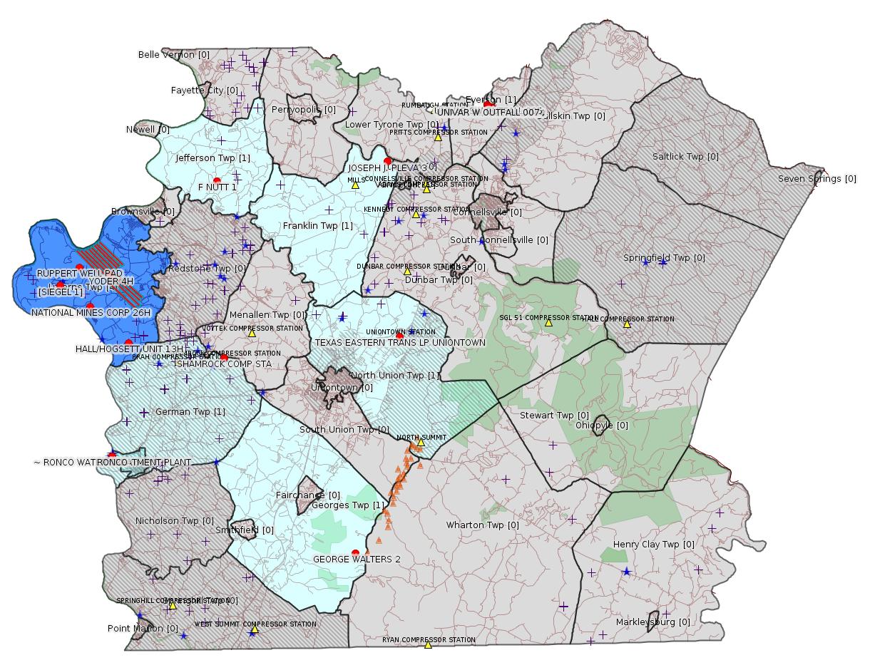
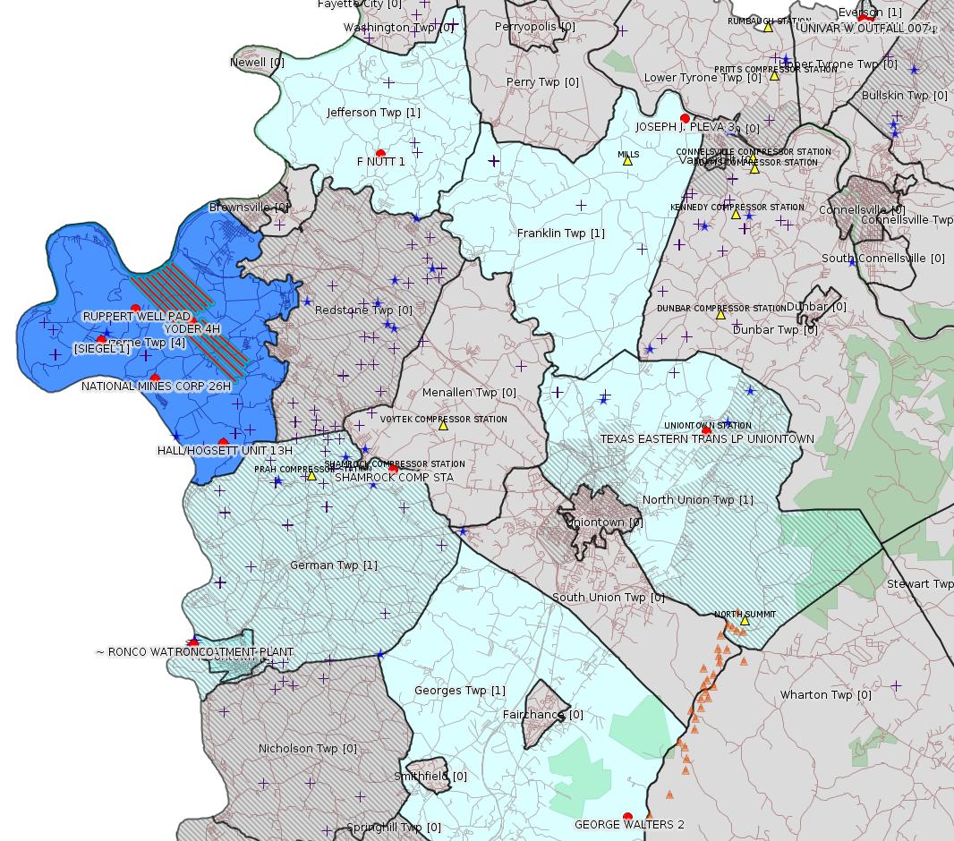
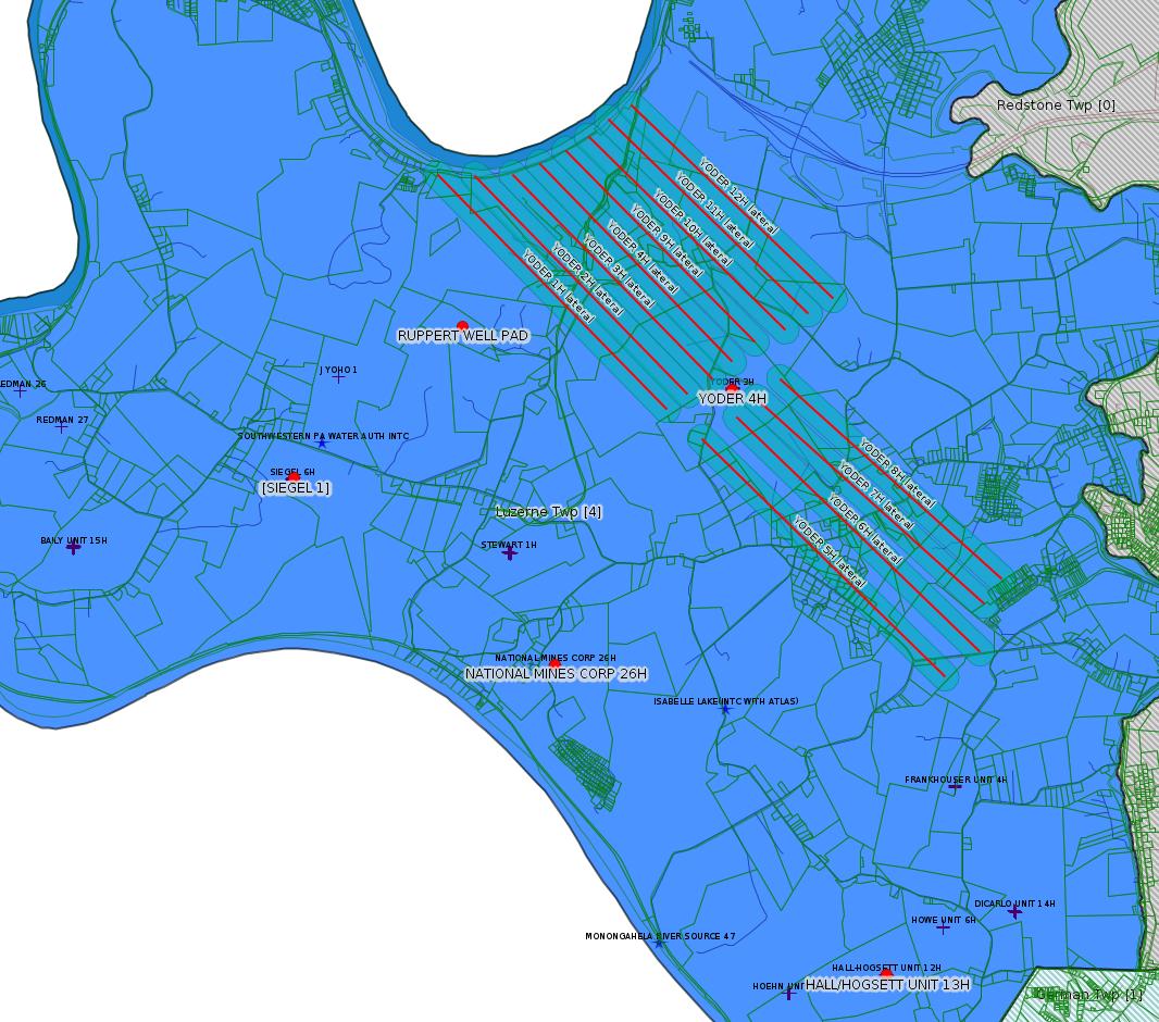
Map
Key
Red dots: items in this permit list with an exact location.
Blue stars: Marcellus Gas Well Water Sources.
Where well laterals are mapped they show in red; a 400-foot buffer surrounding the lateral shows in blue (lavender where it overlaps a mapped mineral tract).
Where mineral tracts are mapped, they show in pink. Mineral tracts can overlap; the overlap will show in red. The precise meaning of "mineral tract" is not clear.
Municipality shading: number of "facilities", with each well counting separately
(includes the red dots):
gray: 0
pale turquoise: 1
turquoise: 2
pale blue: 3
middle blue: 4
dark blue: 5
dark purple: 7
purple: 14
(Color coding may differ from one issue to the next.)
(Note if a project spans multiple municipalities -- e.g. a pipeline -- it will show in the count for each municipality.)
The number of facilities also follows the municipality name in brackets.
Municipality counts are based on the way the permit is listed by DEP; DEP has been known to get a municipality wrong.
Locations in brackets identify a precise location used to locate a surrogate for the actual site being permitted (e.g. locating a well pad or pipeline by the known location of a well.) Locations labeled beginning with "~" and ending in "[?]" are approximate and speculative based on inferences using on-line property and lease records. These are marked in the text as "[Approximate, Speculative]
Cross-hatching: Environmental Justice Areas
Yellow triangles: Compressor Stations
Orange triangles: Storage Field Wells (currently Dominion North Summit Storage Field)
Crosses: SPUD Unconventional well permits
Green: "Natural areas", e.g. state game lands, state forests
Yellow triangles: Compressor Stations
Orange triangles: Storage Field Wells (currently Dominion North Summit Storage Field)
Crosses: SPUD Unconventional well permits
Green: "Natural areas", e.g. state game lands, state forests
More Maps
 |
 |
Source: Pennsylvania Bulletin
NOTICES
DEPARTMENT OF
ENVIRONMENTAL PROTECTION
Availability of Technical Guidance
[49 Pa.B. 6197]
[Saturday, October 19, 2019]
Technical guidance documents (TGD) are available on the Department of Environmental Protection's (Department) web site at www.elibrary.dep.state.pa.us. The ''Technical Guidance Final Documents'' heading is the link to a menu of the various Department bureaus where each bureau's final TGDs are posted. The ''Technical Guidance Draft Documents'' heading is the link to the Department's draft TGDs.
Ordering Paper Copies of Department Technical Guidance
The Department encourages the use of the Internet to view and download TGDs. When this option is not available, persons can order a paper copy of any of the Department's draft or final TGDs by contacting the Department at (717) 783-8727.
In addition, bound copies of some of the Department's documents are available as Department publications. Check with the appropriate bureau for more information about the availability of a particular document as a publication.
Changes to TGDs
Following is the current list of recent changes. Persons who have questions or comments about a particular document should contact the person whose name and phone number are listed with each document.
Draft Technical Guidance: Substantive Revision
DEP ID: 250-3100-001. Title: Radioactivity Monitoring at Solid Waste Processing and Disposal Facilities. Description: This guidance assists the regulated community with the development of Radiation Protection Action Plans as required in regulation. The primary revisions amend the document to include guidance for the oil and gas industry in response to new provisions in 25 Pa. Code Chapter 78a (relating to unconventional wells) requiring unconventional oil and gas operators to comply with this technical guidance. Additionally, outdated and redundant information is being removed; guidance is being provided for nonsolid waste recycler operations; environmental modeling guidance is being improved; and radiation protection standards are being compiled in one place for subject facilities.
Written Comments: Interested persons may submit written comments on this draft TGD through Monday, November 18, 2019. Comments submitted by facsimile will not be accepted. All comments, including comments submitted by e-mail, must include the commentator's name and address. Commentators are encouraged to submit comments using the Department's online eComment tool at www.ahs.dep.pa.gov/eComment or by e-mail to ecomment@pa.gov. Written comments can be mailed to the Technical Guidance Coordinator, Department of Environmental Protection, Policy Office, Rachel Carson State Office Building, P.O. Box 2063, Harrisburg, PA 17105-2063.
Contact: Questions regarding this TGD can be directed to Kristina Hoffman at krihoffman@pa.gov or (717) 787-2480.
Effective Date: Upon publication of notice as final in the Pennsylvania Bulletin.
PATRICK McDONNELL,
Secretary
[Pa.B. Doc. No. 19-1559. Filed for public inspection October 18, 2019, 9:00 a.m.]
<https://www.pabulletin.com/secure/data/vol49/49-42/1559.html>
The actual technical guidance document is available here:
<http://www.depgreenport.state.pa.us/elibrary/GetDocument?docId=1507609&DocName=GUIDANCE DOCUMENT ON RADIOACTIVITY MONITORING AT SOLID WASTE PROCESSING AND DISPOSAL FACILITIES.PDF>
[See Notes.]
-------------------------
Source: eNOTICE
(+ PA
Oil and Gas Mapping, Well
Pad Report.) Well Details via Data
Portal Services: Oil and Gas Wells All (ID: 3).
Please see the Disclaimer below regarding Parcel Id data.
Authorization ID: 1292582
Permit number: 051-24580
Site: HALL/HOGSETT UNIT WELL SITES ESCGP-EXPEDITED
Client: CHEVRON APPALACHIA LLC
Authorization type: Alt Method of Equipping, Casing, or Venting Well
Application type: New
Authorization is for: FACILITY
Date received: 10/18/2019
Status: Pending
Permit Decision Guarantee Applies?: Yes
Permit Decision Guarantee status: ACTIVE
Sub-Facilities for Authorization:
Sub-Facility ID Sub-Facility Name Description
1104887 HALL/HOGSETT UNIT 13H Well
1104886 HALL/HOGSETT UNIT 13H Well
Permit Review Notes:
Date Review Note
10/18/2019 The permit application package is complete, has been accepted, and is undergoing technical review.
<https://www.ahs.dep.pa.gov/eFACTSWeb/searchResults_singleAuth.aspx?AuthID=1292582>
Site Programs:
Oil & Gas
Site Municipalities:
German Twp, Fayette County
Luzerne Twp, Fayette County
Well Details:
Permit Number: 051-24580
Well Name: HALL/HOGSETT UNIT 13H
Unconventional Well: Y
Well Configuration: Horizontal Well
Well Type: GAS
Well Status: Regulatory Inactive Status
Coal Association: Coal
Conservation Well: Y
Primary Facility ID: 764261
Site ID: 736604
Site Name: HALL/HOGSETT UNIT WELL SITES ESCGP-EXPEDITED
Well Pad ID: 145470
Well Pad Name: HALL/HOGSETT UNIT
Storage Field:
Operator: CHEVRON APPALACHIA LLC
Operator Number: OGO-39307
Permit Date: 2013-04-30
Permit Date Expires: 2014-04-30
SPUD Date: 2013-05-17
Date Plugged:
UIC ID:
UIC Type:
Surface Elevation: 1006
County: Fayette
Municipality: Luzerne Twp
Location: 39.929328,-79.908822
Map URL: <http://www.openstreetmap.org/?mlat=39.929328&mlon=-79.908822#map=15/39.929328/-79.908822>
---
Authorization ID: 1292572
Permit number: 051-24580
Site: HALL/HOGSETT UNIT WELL SITES ESCGP-EXPEDITED
Client: CHEVRON APPALACHIA LLC
Authorization type: Well Plugging Notice Intent to Plug Single Well
Application type: New
Authorization is for: FACILITY
Date received: 10/18/2019
Status: Pending
Permit Decision Guarantee Applies?: No
Sub-Facilities for Authorization:
Sub-Facility ID Sub-Facility Name Description
1104887 HALL/HOGSETT UNIT 13H Well
1104886 HALL/HOGSETT UNIT 13H Well
Permit Review Notes:
Date Review Note
10/18/2019 The permit application package is complete, has been accepted, and is undergoing technical review.
<https://www.ahs.dep.pa.gov/eFACTSWeb/searchResults_singleAuth.aspx?AuthID=1292572>
Site Programs:
Oil & Gas
Site Municipalities:
German Twp, Fayette County
Luzerne Twp, Fayette County
Well Details above
---
Authorization ID: 1291761
Permit number: 26-00413
Site: TEXAS EASTERN TRANS LP UNIONTOWN
Client: TEXAS EASTERN TRANS LP
Authorization type: Major Facility Operating Permit
Application type: Amendment
Authorization is for: FACILITY
Date received: 06/19/2019
Status: Pending
Permit Decision Guarantee Applies?: No
Permit Review Notes:
Date Review Note
10/11/2019 The permit application package is complete, has been accepted, and is undergoing technical review.
<https://www.ahs.dep.pa.gov/eFACTSWeb/searchResults_singleAuth.aspx?AuthID=1291761>
Site Programs:
Air Quality
Waste Management
Site Municipalities:
North Union Twp, Fayette County
Uniontown [Incorrect -jr], Fayette County
---
Authorization ID: 1291565
Permit number: ESX17-051-0002
Site: RUPPERT WELL PAD ESCGP ESX17-051-0002
Client: CHEVRON APPALACHIA LLC
Authorization type: Expedited E&S Stormwater General Permit 1
Application type: Notification
Authorization is for: SITE
Date received: 10/08/2019
Status: Pending
Permit Decision Guarantee Applies?: No
Permit Review Notes:
Date Review Note
10/9/2019 The permit application package is complete, has been accepted, and is undergoing technical review.
<https://www.ahs.dep.pa.gov/eFACTSWeb/searchResults_singleAuth.aspx?AuthID=1291565>
Site Programs:
Site Municipalities:
Luzerne Twp, Fayette County
---
Authorization ID: 1291380
Permit number: 26-00588B
Site: SHAMROCK COMP STA
Client: LAUREL MTN MIDSTREAM OPR LLC
Authorization type: Minor Facility Plan Approval New Source Performance Std
Application type: Extension
Authorization is for: FACILITY
Date received: 10/08/2019
Status: Pending
Permit Decision Guarantee Applies?: No
Permit Review Notes:
Date Review Note
10/9/2019 The permit application package is complete, has been accepted, and is undergoing technical review.
<https://www.ahs.dep.pa.gov/eFACTSWeb/searchResults_singleAuth.aspx?AuthID=1291380>
Site Programs:
Air Quality
Site Municipalities:
German Twp, Fayette County
[See Notes.]
---
Authorization ID: 1289874
Permit number: 051-00116
Site: GEORGE WALTERS 2 WELL
Client: DOMINION ENERGY TRANS INC
Authorization type: Well Plugging Notice Intent to Plug Single Well
Application type: New
Authorization is for: FACILITY
Date received: 09/27/2019
Status: Pending
Permit Decision Guarantee Applies?: No
Sub-Facilities for Authorization:
Sub-Facility ID Sub-Facility Name Description
56076 GEORGE WALTERS 2 Well
Permit Review Notes:
Date Review Note
10/16/2019 The technical review and decision review are complete and either the permit decision and/or permit issuance are forthcoming.
9/27/2019 The permit application package is complete, has been accepted, and is undergoing technical review.
<https://www.ahs.dep.pa.gov/eFACTSWeb/searchResults_singleAuth.aspx?AuthID=1289874>
Site Programs:
Oil & Gas
Site Municipalities:
Georges Twp, Fayette County
Well Details:
Permit Number: 051-00116
Well Name: GEORGE WALTERS 2
Unconventional Well: N
Well Configuration: Vertical Well
Well Type: GAS
Well Status: Active
Coal Association: Coal
Conservation Well: N
Primary Facility ID: 42546
Site ID: 40794
Site Name: GEORGE WALTERS 2 WELL
Well Pad ID: 0
Well Pad Name:
Storage Field:
Operator: DOMINION ENERGY TRANS INC
Operator Number: OGO-2239
Permit Date: 1986-02-25
Permit Date Expires:
SPUD Date: 1800-01-01
Date Plugged:
UIC ID:
UIC Type:
Surface Elevation: 0
County: Fayette
Municipality: Georges Twp
Location: 39.785,-79.711278
Map URL: <http://www.openstreetmap.org/?mlat=39.785&mlon=-79.711278#map=15/39.785/-79.711278>
---
Authorization ID: 1289255
Permit number: ESG072619002-00
Site: Siegel Well Connect Pipeline Project
Client: LAUREL MTN MIDSTREAM OPR LLC
Authorization type: Erosion and Sediment Control General Permit 3 Expedited
Application type: New
Authorization is for: SITE
Date received: 09/23/2019
Status: Pending
Permit Decision Guarantee Applies?: Yes
Permit Decision Guarantee status: ACTIVE
Permit Review Notes:
Date Review Note
10/17/2019 The permit application package is complete, has been accepted, and is undergoing technical review.
<https://www.ahs.dep.pa.gov/eFACTSWeb/searchResults_singleAuth.aspx?AuthID=1289255>
Site Programs:
Site Municipalities:
Luzerne Twp, Fayette County
Location [of Siegel 1]: 39.968972;-79.968794
---
Authorization ID: 1288638
Permit number: PAR236137
Site: UNIVAR SOLUTIONS USA INC EVERSON PLANT
Client: UNIVAR SOLUTIONS USA INC
Authorization type: PAG-03 Discharge of Stormwater Assoc w Industrial Activities
Application type: Transfer
Authorization is for: FACILITY
Date received: 09/03/2019
Status: Issued on 10/4/2019
Permit Decision Guarantee Applies?: No
Sub-Facilities for Authorization:
Sub-Facility ID Sub-Facility Name Description
1110331 SW OUTFALL 001 Discharge Point
Location: 40.085978,-79.58585
Map URL: <http://www.openstreetmap.org/?mlat=40.085978&mlon=-79.58585#map=15/40.085978/-79.58585>
1110723 SW OUTFALL 002 Discharge Point
Location: 40.085964,-79.586283
Map URL: <http://www.openstreetmap.org/?mlat=40.085964&mlon=-79.586283#map=15/40.085964/-79.586283>
1110724 SW OUTFALL 003 Discharge Point
Location: 40.085864,-79.587031
Map URL: <http://www.openstreetmap.org/?mlat=40.085864&mlon=-79.587031#map=15/40.085864/-79.587031>
1110725 SW OUTFALL 004 Discharge Point
Location: 40.085828,-79.587653
Map URL: <http://www.openstreetmap.org/?mlat=40.085828&mlon=-79.587653#map=15/40.085828/-79.587653>
1110726 SW OUTFALL 005 Discharge Point
Location: 40.087217,-79.589686
Map URL: <http://www.openstreetmap.org/?mlat=40.087217&mlon=-79.589686#map=15/40.087217/-79.589686>
1110727 SW OUTFALL 006 Discharge Point
Location: 40.087258,-79.589569
Map URL: <http://www.openstreetmap.org/?mlat=40.087258&mlon=-79.589569#map=15/40.087258/-79.589569>
1110728 SW OUTFALL 007 Discharge Point
Location: 40.086547,-79.589419
Map URL: <http://www.openstreetmap.org/?mlat=40.086547&mlon=-79.589419#map=15/40.086547/-79.589419>
Permit Review Notes:
Date Review Note
10/3/2019 The technical review and decision review are complete and either the permit decision and/or permit issuance are forthcoming.
9/26/2019 Applicant has been issued a deficiency letter. If applicable, this application no longer qualifies for the Permit Decision Guarantee.
9/18/2019 The permit application package is complete, has been accepted, and is undergoing technical review.
<https://www.ahs.dep.pa.gov/eFACTSWeb/searchResults_singleAuth.aspx?AuthID=1288638>
Site Programs:
Air Quality
Clean Water
Waste Management
Water Planning and Conservation
Site Municipalities:
Bullskin Twp [Incorrect, should be Everson Borough -jr], Fayette County
---
Authorization ID: 1282037
Permit number: WMGR123SW001
Site: RONCO
Client: SHALLENBERGER CONST INC
Authorization type: Minor Modification to an Existing Fac
Application type: Modification
Authorization is for: FACILITY
Date received: 07/30/2019
Status: Pending
Permit Decision Guarantee Applies?: Yes
Permit Decision Guarantee status: VOID
Permit Review Notes:
Date Review Note
10/18/2019 Applicant has been issued a deficiency letter. If applicable, this application no longer qualifies for the Permit Decision Guarantee.
8/15/2019 Applicant has been issued a deficiency letter. If applicable, this application no longer qualifies for the Permit Decision Guarantee.
<https://www.ahs.dep.pa.gov/eFACTSWeb/searchResults_singleAuth.aspx?AuthID=1282037>
Site Programs:
Radiation Protection
Waste Management
Site Municipalities:
Masontown Boro, Fayette County
---
Authorization ID: 1274218
Permit number: E26-07-006
Site: RONCO PLANT JPA 326-07-006
Client: APPALACHIAN WATER SVC LLC
Authorization type: Water Obstruction & Encroachment Pmt
Application type: New
Authorization is for: FACILITY
Date received: 05/13/2019
Status: Pending
Permit Decision Guarantee Applies?: Yes
Permit Decision Guarantee status: VOID
Sub-Facilities for Authorization:
Sub-Facility ID Sub-Facility Name Description
1287361 RONCO PLANT JPA 326-07-006 Pipeline or Conduit
1294699 WATER INTAKE STRUCTURE - MONONGAHELA RIVER Submerged Lands License Agreement
Location: 39.854167,-79.924578
Map URL: <http://www.openstreetmap.org/?mlat=39.854167&mlon=-79.924578#map=15/39.854167/-79.924578>
Permit Review Notes:
Date Review Note
10/17/2019 The technical review and decision review are complete and either the permit decision and/or permit issuance are forthcoming.
8/21/2019 DEP's interim review is complete. Final decision review/permit issuance is pending receipt of comments/approvals from other state or federal resources agencies.
8/21/2019 DEP's interim review is complete. Final decision review/permit issuance is pending receipt of comments/approvals from other state or federal resources agencies.
7/19/2019 Applicant has been issued a deficiency letter. If applicable, this application no longer qualifies for the Permit Decision Guarantee.
<https://www.ahs.dep.pa.gov/eFACTSWeb/searchResults_singleAuth.aspx?AuthID=1274218>
Site Programs:
Water Planning and Conservation
Site Municipalities:
Masontown Boro, Fayette County
Presumed Parcel Id: 21010001
-------------------------
Source: DEP
Oil and Gas Electronic NotificationsPlease see the Disclaimer below regarding Parcel Id data.
Authorization ID: 1292582
Permit number: 051-24580
Site: HALL/HOGSETT UNIT WELL SITES ESCGP-EXPEDITED
Client: CHEVRON APPALACHIA LLC
Authorization type: Alt Method of Equipping, Casing, or Venting Well
Application type: New
Authorization is for: FACILITY
Date received: 10/18/2019
Status: Pending
Permit Decision Guarantee Applies?: Yes
Permit Decision Guarantee status: ACTIVE
Sub-Facilities for Authorization:
Sub-Facility ID Sub-Facility Name Description
1104887 HALL/HOGSETT UNIT 13H Well
1104886 HALL/HOGSETT UNIT 13H Well
Permit Review Notes:
Date Review Note
10/18/2019 The permit application package is complete, has been accepted, and is undergoing technical review.
<https://www.ahs.dep.pa.gov/eFACTSWeb/searchResults_singleAuth.aspx?AuthID=1292582>
Site Programs:
Oil & Gas
Site Municipalities:
German Twp, Fayette County
Luzerne Twp, Fayette County
Well Details:
Permit Number: 051-24580
Well Name: HALL/HOGSETT UNIT 13H
Unconventional Well: Y
Well Configuration: Horizontal Well
Well Type: GAS
Well Status: Regulatory Inactive Status
Coal Association: Coal
Conservation Well: Y
Primary Facility ID: 764261
Site ID: 736604
Site Name: HALL/HOGSETT UNIT WELL SITES ESCGP-EXPEDITED
Well Pad ID: 145470
Well Pad Name: HALL/HOGSETT UNIT
Storage Field:
Operator: CHEVRON APPALACHIA LLC
Operator Number: OGO-39307
Permit Date: 2013-04-30
Permit Date Expires: 2014-04-30
SPUD Date: 2013-05-17
Date Plugged:
UIC ID:
UIC Type:
Surface Elevation: 1006
County: Fayette
Municipality: Luzerne Twp
Location: 39.929328,-79.908822
Map URL: <http://www.openstreetmap.org/?mlat=39.929328&mlon=-79.908822#map=15/39.929328/-79.908822>
---
Authorization ID: 1292572
Permit number: 051-24580
Site: HALL/HOGSETT UNIT WELL SITES ESCGP-EXPEDITED
Client: CHEVRON APPALACHIA LLC
Authorization type: Well Plugging Notice Intent to Plug Single Well
Application type: New
Authorization is for: FACILITY
Date received: 10/18/2019
Status: Pending
Permit Decision Guarantee Applies?: No
Sub-Facilities for Authorization:
Sub-Facility ID Sub-Facility Name Description
1104887 HALL/HOGSETT UNIT 13H Well
1104886 HALL/HOGSETT UNIT 13H Well
Permit Review Notes:
Date Review Note
10/18/2019 The permit application package is complete, has been accepted, and is undergoing technical review.
<https://www.ahs.dep.pa.gov/eFACTSWeb/searchResults_singleAuth.aspx?AuthID=1292572>
Site Programs:
Oil & Gas
Site Municipalities:
German Twp, Fayette County
Luzerne Twp, Fayette County
Well Details above
---
Authorization ID: 1291761
Permit number: 26-00413
Site: TEXAS EASTERN TRANS LP UNIONTOWN
Client: TEXAS EASTERN TRANS LP
Authorization type: Major Facility Operating Permit
Application type: Amendment
Authorization is for: FACILITY
Date received: 06/19/2019
Status: Pending
Permit Decision Guarantee Applies?: No
Permit Review Notes:
Date Review Note
10/11/2019 The permit application package is complete, has been accepted, and is undergoing technical review.
<https://www.ahs.dep.pa.gov/eFACTSWeb/searchResults_singleAuth.aspx?AuthID=1291761>
Site Programs:
Air Quality
Waste Management
Site Municipalities:
North Union Twp, Fayette County
Uniontown [Incorrect -jr], Fayette County
Location: 39.93111,-79.67
Map URL: <https://www.openstreetmap.org/?mlat=39.93111&mlon=-79.67#map=15/39.93111/-79.67>
Presumed Parcel Id: 25120168
Map URL: <https://www.openstreetmap.org/?mlat=39.93111&mlon=-79.67#map=15/39.93111/-79.67>
Presumed Parcel Id: 25120168
---
Authorization ID: 1291565
Permit number: ESX17-051-0002
Site: RUPPERT WELL PAD ESCGP ESX17-051-0002
Client: CHEVRON APPALACHIA LLC
Authorization type: Expedited E&S Stormwater General Permit 1
Application type: Notification
Authorization is for: SITE
Date received: 10/08/2019
Status: Pending
Permit Decision Guarantee Applies?: No
Permit Review Notes:
Date Review Note
10/9/2019 The permit application package is complete, has been accepted, and is undergoing technical review.
<https://www.ahs.dep.pa.gov/eFACTSWeb/searchResults_singleAuth.aspx?AuthID=1291565>
Site Programs:
Site Municipalities:
Luzerne Twp, Fayette County
Location: 39.980714,-79.951394 <http://osm.org/go/ZWpZcmDI--?m=>
Municipalities: Luzerne Twp
Act 14 Notification: <http://faymarwatch.org/documents/SKM_554e17041316431.pdf>
Presumed Parcel Id: 19150099
[See Notes.]
Municipalities: Luzerne Twp
Act 14 Notification: <http://faymarwatch.org/documents/SKM_554e17041316431.pdf>
Presumed Parcel Id: 19150099
[See Notes.]
---
Authorization ID: 1291380
Permit number: 26-00588B
Site: SHAMROCK COMP STA
Client: LAUREL MTN MIDSTREAM OPR LLC
Authorization type: Minor Facility Plan Approval New Source Performance Std
Application type: Extension
Authorization is for: FACILITY
Date received: 10/08/2019
Status: Pending
Permit Decision Guarantee Applies?: No
Permit Review Notes:
Date Review Note
10/9/2019 The permit application package is complete, has been accepted, and is undergoing technical review.
<https://www.ahs.dep.pa.gov/eFACTSWeb/searchResults_singleAuth.aspx?AuthID=1291380>
Site Programs:
Air Quality
Site Municipalities:
German Twp, Fayette County
Location: 39.918333,-79.825
Map URL: <http://www.openstreetmap.org/?mlat=39.918333&mlon=-79.825#map=15/39.918333/-79.825>
Parcel ID: 15140026
Map URL: <http://www.openstreetmap.org/?mlat=39.918333&mlon=-79.825#map=15/39.918333/-79.825>
Parcel ID: 15140026
---
Authorization ID: 1289874
Permit number: 051-00116
Site: GEORGE WALTERS 2 WELL
Client: DOMINION ENERGY TRANS INC
Authorization type: Well Plugging Notice Intent to Plug Single Well
Application type: New
Authorization is for: FACILITY
Date received: 09/27/2019
Status: Pending
Permit Decision Guarantee Applies?: No
Sub-Facilities for Authorization:
Sub-Facility ID Sub-Facility Name Description
56076 GEORGE WALTERS 2 Well
Permit Review Notes:
Date Review Note
10/16/2019 The technical review and decision review are complete and either the permit decision and/or permit issuance are forthcoming.
9/27/2019 The permit application package is complete, has been accepted, and is undergoing technical review.
<https://www.ahs.dep.pa.gov/eFACTSWeb/searchResults_singleAuth.aspx?AuthID=1289874>
Site Programs:
Oil & Gas
Site Municipalities:
Georges Twp, Fayette County
Well Details:
Permit Number: 051-00116
Well Name: GEORGE WALTERS 2
Unconventional Well: N
Well Configuration: Vertical Well
Well Type: GAS
Well Status: Active
Coal Association: Coal
Conservation Well: N
Primary Facility ID: 42546
Site ID: 40794
Site Name: GEORGE WALTERS 2 WELL
Well Pad ID: 0
Well Pad Name:
Storage Field:
Operator: DOMINION ENERGY TRANS INC
Operator Number: OGO-2239
Permit Date: 1986-02-25
Permit Date Expires:
SPUD Date: 1800-01-01
Date Plugged:
UIC ID:
UIC Type:
Surface Elevation: 0
County: Fayette
Municipality: Georges Twp
Location: 39.785,-79.711278
Map URL: <http://www.openstreetmap.org/?mlat=39.785&mlon=-79.711278#map=15/39.785/-79.711278>
---
Authorization ID: 1289255
Permit number: ESG072619002-00
Site: Siegel Well Connect Pipeline Project
Client: LAUREL MTN MIDSTREAM OPR LLC
Authorization type: Erosion and Sediment Control General Permit 3 Expedited
Application type: New
Authorization is for: SITE
Date received: 09/23/2019
Status: Pending
Permit Decision Guarantee Applies?: Yes
Permit Decision Guarantee status: ACTIVE
Permit Review Notes:
Date Review Note
10/17/2019 The permit application package is complete, has been accepted, and is undergoing technical review.
<https://www.ahs.dep.pa.gov/eFACTSWeb/searchResults_singleAuth.aspx?AuthID=1289255>
Site Programs:
Site Municipalities:
Luzerne Twp, Fayette County
Location [of Siegel 1]: 39.968972;-79.968794
---
Authorization ID: 1288638
Permit number: PAR236137
Site: UNIVAR SOLUTIONS USA INC EVERSON PLANT
Client: UNIVAR SOLUTIONS USA INC
Authorization type: PAG-03 Discharge of Stormwater Assoc w Industrial Activities
Application type: Transfer
Authorization is for: FACILITY
Date received: 09/03/2019
Status: Issued on 10/4/2019
Permit Decision Guarantee Applies?: No
Sub-Facilities for Authorization:
Sub-Facility ID Sub-Facility Name Description
1110331 SW OUTFALL 001 Discharge Point
Location: 40.085978,-79.58585
Map URL: <http://www.openstreetmap.org/?mlat=40.085978&mlon=-79.58585#map=15/40.085978/-79.58585>
1110723 SW OUTFALL 002 Discharge Point
Location: 40.085964,-79.586283
Map URL: <http://www.openstreetmap.org/?mlat=40.085964&mlon=-79.586283#map=15/40.085964/-79.586283>
1110724 SW OUTFALL 003 Discharge Point
Location: 40.085864,-79.587031
Map URL: <http://www.openstreetmap.org/?mlat=40.085864&mlon=-79.587031#map=15/40.085864/-79.587031>
1110725 SW OUTFALL 004 Discharge Point
Location: 40.085828,-79.587653
Map URL: <http://www.openstreetmap.org/?mlat=40.085828&mlon=-79.587653#map=15/40.085828/-79.587653>
1110726 SW OUTFALL 005 Discharge Point
Location: 40.087217,-79.589686
Map URL: <http://www.openstreetmap.org/?mlat=40.087217&mlon=-79.589686#map=15/40.087217/-79.589686>
1110727 SW OUTFALL 006 Discharge Point
Location: 40.087258,-79.589569
Map URL: <http://www.openstreetmap.org/?mlat=40.087258&mlon=-79.589569#map=15/40.087258/-79.589569>
1110728 SW OUTFALL 007 Discharge Point
Location: 40.086547,-79.589419
Map URL: <http://www.openstreetmap.org/?mlat=40.086547&mlon=-79.589419#map=15/40.086547/-79.589419>
Permit Review Notes:
Date Review Note
10/3/2019 The technical review and decision review are complete and either the permit decision and/or permit issuance are forthcoming.
9/26/2019 Applicant has been issued a deficiency letter. If applicable, this application no longer qualifies for the Permit Decision Guarantee.
9/18/2019 The permit application package is complete, has been accepted, and is undergoing technical review.
<https://www.ahs.dep.pa.gov/eFACTSWeb/searchResults_singleAuth.aspx?AuthID=1288638>
Site Programs:
Air Quality
Clean Water
Waste Management
Water Planning and Conservation
Site Municipalities:
Bullskin Twp [Incorrect, should be Everson Borough -jr], Fayette County
---
Authorization ID: 1282037
Permit number: WMGR123SW001
Site: RONCO
Client: SHALLENBERGER CONST INC
Authorization type: Minor Modification to an Existing Fac
Application type: Modification
Authorization is for: FACILITY
Date received: 07/30/2019
Status: Pending
Permit Decision Guarantee Applies?: Yes
Permit Decision Guarantee status: VOID
Permit Review Notes:
Date Review Note
10/18/2019 Applicant has been issued a deficiency letter. If applicable, this application no longer qualifies for the Permit Decision Guarantee.
8/15/2019 Applicant has been issued a deficiency letter. If applicable, this application no longer qualifies for the Permit Decision Guarantee.
<https://www.ahs.dep.pa.gov/eFACTSWeb/searchResults_singleAuth.aspx?AuthID=1282037>
Site Programs:
Radiation Protection
Waste Management
Site Municipalities:
Masontown Boro, Fayette County
---
Authorization ID: 1274218
Permit number: E26-07-006
Site: RONCO PLANT JPA 326-07-006
Client: APPALACHIAN WATER SVC LLC
Authorization type: Water Obstruction & Encroachment Pmt
Application type: New
Authorization is for: FACILITY
Date received: 05/13/2019
Status: Pending
Permit Decision Guarantee Applies?: Yes
Permit Decision Guarantee status: VOID
Sub-Facilities for Authorization:
Sub-Facility ID Sub-Facility Name Description
1287361 RONCO PLANT JPA 326-07-006 Pipeline or Conduit
1294699 WATER INTAKE STRUCTURE - MONONGAHELA RIVER Submerged Lands License Agreement
Location: 39.854167,-79.924578
Map URL: <http://www.openstreetmap.org/?mlat=39.854167&mlon=-79.924578#map=15/39.854167/-79.924578>
Permit Review Notes:
Date Review Note
10/17/2019 The technical review and decision review are complete and either the permit decision and/or permit issuance are forthcoming.
8/21/2019 DEP's interim review is complete. Final decision review/permit issuance is pending receipt of comments/approvals from other state or federal resources agencies.
8/21/2019 DEP's interim review is complete. Final decision review/permit issuance is pending receipt of comments/approvals from other state or federal resources agencies.
7/19/2019 Applicant has been issued a deficiency letter. If applicable, this application no longer qualifies for the Permit Decision Guarantee.
<https://www.ahs.dep.pa.gov/eFACTSWeb/searchResults_singleAuth.aspx?AuthID=1274218>
Site Programs:
Water Planning and Conservation
Site Municipalities:
Masontown Boro, Fayette County
Location [approximate]:
39.852778,-79.924722 <http://osm.org/go/ZWpM2V0y--?m=>
Presumed Parcel Id: 21010001
-------------------------
NOTIFICATION_ID: 50266
OGO: 39307
OPERATOR: CHEVRON APPALACHIA LLC
API_PERMIT: 051-24655
SPUD_DATE: 05/07/2018
COUNTY: Fayette
MUNICIPALITY: Luzerne
LATITUDE: 39.975564
LONGITUDE: -79.923878
SUBJECT: [NOTIFICATION]: Stimulation notification 58 Pa. C.S. 3211(f)(2) for well API 37-051-24655-00-00
QUESTION: Date and approximate time action is to occur
ANSWER: Date: 10/14/2019 Time: 6:00am
SENT_DATE: 10/11/2019 8:27:31 AM
SENT_SUCCESS: Yes
LAST_RESENT_DATE:
RESENT_SUCCESS:
REGION: EP DOGO SWDO Dstr Off
Well Details:
Permit Number: 051-24655
Well Name: YODER 4H
Unconventional Well: Y
Well Configuration: Horizontal Well
Well Type: GAS
Well Status: Active
Coal Association: NonCoal
Conservation Well: N
Primary Facility ID: 824629
Site ID: 790607
Site Name: YODER WELL PAD ESCGP-2 EXPEDITED
Well Pad ID: 153100
Well Pad Name: YODER
Storage Field:
Operator: CHEVRON APPALACHIA LLC
Operator Number: OGO-39307
Permit Date: 2018-03-06
Permit Date Expires: 2019-03-06
SPUD Date: 2018-05-07
Date Plugged:
UIC ID:
UIC Type:
Surface Elevation: 1118
County: Fayette
Municipality: Luzerne Twp
Location: 39.975564,-79.923878
Map URL: <http://www.openstreetmap.org/?mlat=39.975564&mlon=-79.923878#map=15/39.975564/-79.923878>
OG WELLS PERMIT DOCS:
2018-03-08: Final Permit Documents, Name: 1217023 (for Authorization: 1217023):
<http://www.depgis.state.pa.us/pdfHandler/pdFHandler.ashx?Doc=NTY5Nzg1&ext=PDF>
2018-03-08: Other Permit Documents, Name: Non-Coal Determination 051-24655 (for Authorization: 1217023):
<http://www.depgis.state.pa.us/pdfHandler/pdFHandler.ashx?Doc=NTY3ODAw&ext=PDF>
Electronically Submitted Records:
2018-03-08: Submission for Authorization 1217023
Pennsylvania Natural Diversity Inventory Form: Yoder PNDI.PDF
<http://www.depgis.state.pa.us/eWellDocHandler/pdFHandler.ashx?Doc=NDgyNTg4&ext=PDF>
Location Plat: Yoder Well Plat 4H.dwg
<http://www.depgis.state.pa.us/eWellDocHandler/pdFHandler.ashx?Doc=NDgyNTg5&ext=PDF>
Justification for Non-Coal Well: Yoder Non Coal Packet.pdf
<http://www.depgis.state.pa.us/eWellDocHandler/pdFHandler.ashx?Doc=NDgyNTkw&ext=PDF>
Well Cross-Section Diagram: Yoder 4H_Page 4.pdf
<http://www.depgis.state.pa.us/eWellDocHandler/pdFHandler.ashx?Doc=NDgyNTkx&ext=PDF>
Permit Application to Drill and Operate a Well: 1679408.pdf
<http://www.depgis.state.pa.us/eWellDocHandler/pdFHandler.ashx?Doc=NDgzMjc3&ext=PDF>
---
NOTIFICATION_ID: 50267
OGO: 39307
OPERATOR: CHEVRON APPALACHIA LLC
API_PERMIT: 051-24660
SPUD_DATE: 05/07/2018
COUNTY: Fayette
MUNICIPALITY: Luzerne
LATITUDE: 39.975683
LONGITUDE: -79.923764
SUBJECT: [NOTIFICATION]: Stimulation notification 58 Pa. C.S. 3211(f)(2) for well API 37-051-24660-00-00
QUESTION: Date and approximate time action is to occur
ANSWER: Date: 10/14/2019 Time: 6:00am
SENT_DATE: 10/11/2019 8:29:33 AM
SENT_SUCCESS: Yes
LAST_RESENT_DATE:
RESENT_SUCCESS:
REGION: EP DOGO SWDO Dstr Off
Well Details:
Permit Number: 051-24660
Well Name: YODER 9H
Unconventional Well: Y
Well Configuration: Horizontal Well
Well Type: GAS
Well Status: Active
Coal Association: NonCoal
Conservation Well: N
Primary Facility ID: 824634
Site ID: 790607
Site Name: YODER WELL PAD ESCGP-2 EXPEDITED
Well Pad ID: 153100
Well Pad Name: YODER
Storage Field:
Operator: CHEVRON APPALACHIA LLC
Operator Number: OGO-39307
Permit Date: 2018-03-06
Permit Date Expires: 2019-03-06
SPUD Date: 2018-05-07
Date Plugged:
UIC ID:
UIC Type:
Surface Elevation: 1118
County: Fayette
Municipality: Luzerne Twp
Location: 39.975683,-79.923764
Map URL: <http://www.openstreetmap.org/?mlat=39.975683&mlon=-79.923764#map=15/39.975683/-79.923764>
OG WELLS PERMIT DOCS:
2018-03-08: Other Permit Documents, Name: 1217028 (for Authorization: 1217028):
<http://www.depgis.state.pa.us/pdfHandler/pdFHandler.ashx?Doc=NTY5ODEy&ext=PDF>
2018-03-08: Other Permit Documents, Name: Non-Coal Determination 051-24660 (for Authorization: 1217028):
<http://www.depgis.state.pa.us/pdfHandler/pdFHandler.ashx?Doc=NTY4MTg3&ext=PDF>
Electronically Submitted Records:
2018-03-08: Submission for Authorization 1217028
Pennsylvania Natural Diversity Inventory Form: Yoder PNDI.PDF
<http://www.depgis.state.pa.us/eWellDocHandler/pdFHandler.ashx?Doc=NDgyNzAx&ext=PDF>
Location Plat: Yoder Well Plat 9H.dwg
<http://www.depgis.state.pa.us/eWellDocHandler/pdFHandler.ashx?Doc=NDgyNzAy&ext=PDF>
Justification for Non-Coal Well: Yoder Non Coal Packet.pdf
<http://www.depgis.state.pa.us/eWellDocHandler/pdFHandler.ashx?Doc=NDgyNzAz&ext=PDF>
Well Cross-Section Diagram: Yoder 9H_Page 4.pdf
<http://www.depgis.state.pa.us/eWellDocHandler/pdFHandler.ashx?Doc=NDgyNzA0&ext=PDF>
Permit Application to Drill and Operate a Well: 1679576.pdf
<http://www.depgis.state.pa.us/eWellDocHandler/pdFHandler.ashx?Doc=NDgzMjk1&ext=PDF>
---
NOTIFICATION_ID: 50268
OGO: 39307
OPERATOR: CHEVRON APPALACHIA LLC
API_PERMIT: 051-24661
SPUD_DATE: 05/07/2018
COUNTY: Fayette
MUNICIPALITY: Luzerne
LATITUDE: 39.975644
LONGITUDE: -79.923767
SUBJECT: [NOTIFICATION]: Stimulation notification 58 Pa. C.S. 3211(f)(2) for well API 37-051-24661-00-00
QUESTION: Date and approximate time action is to occur
ANSWER: Date: 10/14/2019 Time: 6:00am
SENT_DATE: 10/11/2019 8:30:21 AM
SENT_SUCCESS: Yes
LAST_RESENT_DATE:
RESENT_SUCCESS:
REGION: EP DOGO SWDO Dstr Off
Well Details:
Permit Number: 051-24661
Well Name: YODER 10H
Unconventional Well: Y
Well Configuration: Horizontal Well
Well Type: GAS
Well Status: Active
Coal Association: NonCoal
Conservation Well: N
Primary Facility ID: 824635
Site ID: 790607
Site Name: YODER WELL PAD ESCGP-2 EXPEDITED
Well Pad ID: 153100
Well Pad Name: YODER
Storage Field:
Operator: CHEVRON APPALACHIA LLC
Operator Number: OGO-39307
Permit Date: 2018-03-06
Permit Date Expires: 2019-03-06
SPUD Date: 2018-05-07
Date Plugged:
UIC ID:
UIC Type:
Surface Elevation: 1118
County: Fayette
Municipality: Luzerne Twp
Location: 39.975644,-79.923767
Map URL: <http://www.openstreetmap.org/?mlat=39.975644&mlon=-79.923767#map=15/39.975644/-79.923767>
OG WELLS PERMIT DOCS:
2018-03-08: Final Permit Documents, Name: 1217029 (for Authorization: 1217029):
<http://www.depgis.state.pa.us/pdfHandler/pdFHandler.ashx?Doc=NTY5ODA3&ext=PDF>
2018-03-08: Other Permit Documents, Name: Non-Coal Determination 051-24661 (for Authorization: 1217029):
<http://www.depgis.state.pa.us/pdfHandler/pdFHandler.ashx?Doc=NTY4MTkx&ext=PDF>
Electronically Submitted Records:
2018-03-08: Submission for Authorization 1217029
Pennsylvania Natural Diversity Inventory Form: Yoder PNDI.PDF
<http://www.depgis.state.pa.us/eWellDocHandler/pdFHandler.ashx?Doc=NDgyNzI4&ext=PDF>
Location Plat: Yoder Well Plat 10H.dwg
<http://www.depgis.state.pa.us/eWellDocHandler/pdFHandler.ashx?Doc=NDgyNzI5&ext=PDF>
Justification for Non-Coal Well: Yoder Non Coal Packet.pdf
<http://www.depgis.state.pa.us/eWellDocHandler/pdFHandler.ashx?Doc=NDgyNzMw&ext=PDF>
Well Cross-Section Diagram: Yoder 10H_Page 4.pdf
<http://www.depgis.state.pa.us/eWellDocHandler/pdFHandler.ashx?Doc=NDgyNzMx&ext=PDF>
Permit Application to Drill and Operate a Well: 1679581.pdf
<http://www.depgis.state.pa.us/eWellDocHandler/pdFHandler.ashx?Doc=NDgzMjk4&ext=PDF>
---
NOTIFICATION_ID: 50387
OGO: 39307
OPERATOR: CHEVRON APPALACHIA LLC
API_PERMIT: 051-24580
SPUD_DATE: 05/17/2013
COUNTY: Fayette
MUNICIPALITY: Luzerne
LATITUDE: 39.929328
LONGITUDE: -79.908822
SUBJECT: [NOTIFICATION]: Abandonment or plugging notification 58 Pa. C.S. 3211(f)(2) for well API 37-051-24580-00-00
QUESTION: Date and approximate time action is to occur
ANSWER: Date: 10/22/2019 Time: 6:30am
SENT_DATE: 10/21/2019 6:25:45 AM
SENT_SUCCESS: Yes
LAST_RESENT_DATE:
RESENT_SUCCESS:
REGION: EP DOGO SWDO Dstr Off
Well Details above
Well Name: HALL/HOGSETT UNIT 13H
-------------------------
Source:
Oil
and Gas Compliance Report
OPERATOR: ALLIANCE PETRO CO LLC
INSPECTION_ID: 2946947
INSPECTION_DATE: 10/04/2019
INSPECTION_TYPE: Incident- Response to Accident or Event
API_PERMIT: 051-20889
FARM_NAME: JOSEPH J. PLEVA 3
UNCONVENTIONAL: No
SITE_ID: 459912
SITE_NAME: JOSEPH J PLEVA 3 OG WELL
FACILITY_TYPE: Oil & Gas Location
INSPECTION_CATEGORY: Primary Facility
REGION: EP DOGO SWDO Dstr Off
COUNTY: Fayette
MUNICIPALITY: Franklin Twp
INSPECTOR: NAJEWICZ, JUSTIN
INSPECTION_SOURCE: SAIR
INSPECTION_RESULT_DESCRIPTION: Violation(s) Noted
INSPECTION_COMMENT: "On 10/03/19 Joshua Martz of Diversified Gas and Oil reported a spill of 10-15 gallons of crude oil occurred at the site. In an attempt to bypass another well, the oil tank was overflowed, resulting in the release of crude oil to the ground surface. Martz indicated the spill was being remediated.
On 10/04/19 I, along with Environmental Group Manager Dave McDermott, conducted an incident response inspection.
Multiple plastic buckets containing impacted material were observed. Visibly impacted soils were still present. The Department recommends additional remediation efforts be conducted.
A heavily corroded surface line was observed that contained a hole in it. The Department recommends the line is removed, repaired, or replaced.
No dike or method of secondary containment was observed. The Department requests Alliance Petroleum indicate the total volume of the on-site tank and provide either the calculations to determine tank volume or manufacturer information for the tank."
VIOLATION_ID: 865734
VIOLATION_DATE: 10/04/2019
VIOLATION_CODE: 78.57(a) - CONTROL, STORAGE AND DISPOSAL OF PRODUCTION FLUIDS - Operator failed to collect the brine and other fluids produced during operation, service and plugging of the well in a tank, pit or a series of pits or tanks, or other device approved by the Department or Operator discharged brine or other fluids on or into the ground or into waters of the Commonwealth.
VIOLATION_TYPE: Environmental Health & Safety
VIOLATION_COMMENT:
RESOLVED_DATE:
RESOLUTION_REASON_CODE_DESCRIPTION:
CONTINUING_VIOLATION:
ENFORCEMENT_ID: 380102
ENFORCEMENT_CODE_DESCRIPTION: NOV - Notice of Violation
DATE_EXECUTED: 10/22/2019
ENFORCEMENT_FINAL_DATE:
ENFORCEMENT_FINAL_STATUS:
PENALTY_FINAL_DATE:
PENALTY_FINAL_STATUS_CODE_DESCRIPTION:
PENALTY_AMOUNT:
TOTAL_AMOUNT_COLLECTED:
VIOLATION_ID: 865736
VIOLATION_DATE: 10/04/2019
VIOLATION_CODE: 78.54 - GENERAL REQUIREMENTS - Operator failed to control and dispose of fluids, residual waste and drill cuttings, including tophole water, brines, drilling fluids, drilling muds, stimulation fluids, well servicing fluids, oil, and production fluids in a manner that prevents pollution of the waters of the Commonwealth.
VIOLATION_TYPE: Environmental Health & Safety
VIOLATION_COMMENT:
RESOLVED_DATE:
RESOLUTION_REASON_CODE_DESCRIPTION:
CONTINUING_VIOLATION:
ENFORCEMENT_ID: 380102
ENFORCEMENT_CODE_DESCRIPTION: NOV - Notice of Violation
DATE_EXECUTED: 10/22/2019
ENFORCEMENT_FINAL_DATE:
ENFORCEMENT_FINAL_STATUS:
PENALTY_FINAL_DATE:
PENALTY_FINAL_STATUS_CODE_DESCRIPTION:
PENALTY_AMOUNT:
TOTAL_AMOUNT_COLLECTED:
Well Details:
Permit Number: 051-20889
Well Name: JOSEPH J. PLEVA 3
Unconventional Well: N
Well Configuration: Vertical Well
Well Type: GAS
Well Status: Active
Coal Association: Coal
Conservation Well: N
Primary Facility ID: 489444
Site ID: 459912
Site Name: JOSEPH J PLEVA 3 OG WELL
Well Pad ID: 0
Well Pad Name:
Storage Field:
Operator: ALLIANCE PETRO CO LLC
Operator Number: OGO-65675
Permit Date: 1996-12-03
Permit Date Expires: 1997-12-03
SPUD Date: 1997-01-29
Date Plugged:
UIC ID:
UIC Type:
Surface Elevation: 970
County: Fayette
Municipality: Franklin Twp
Location: 40.050415,-79.678572
Map URL: <http://www.openstreetmap.org/?mlat=40.050415&mlon=-79.678572#map=15/40.050415/-79.678572>
Presumed Parcel Id: 1303000901
---
OPERATOR: THE PRODUCTION CO LLC
INSPECTION_ID: 2947190
INSPECTION_DATE: 10/15/2019
INSPECTION_TYPE: Follow-up Inspection
API_PERMIT: 051-24067
FARM_NAME: F NUTT 1
UNCONVENTIONAL: No
SITE_ID: 710268
SITE_NAME: F NUTT 1 OG WELL
FACILITY_TYPE: Oil & Gas Location
INSPECTION_CATEGORY: Primary Facility
REGION: EP DOGO SWDO Dstr Off
COUNTY: Fayette
MUNICIPALITY: Jefferson Twp
INSPECTOR: NAJEWICZ, JUSTIN
INSPECTION_SOURCE: SAIR
INSPECTION_RESULT_DESCRIPTION: Outstanding Violations - Viols Req'd
INSPECTION_COMMENT: On 10/15/19 at approximately 0945 I, along with Environmental Trainee Jessica Morton, conducted a follow up inspection at the site. The well had not been plugged and remained untagged. Violations cited on 08/28/18 documented in inspection report # 2768270 remain outstanding, but the violation codes have been updated to reflect current regulations.
VIOLATION_ID: 865607
VIOLATION_DATE: 10/15/2019
VIOLATION_CODE: 78.91(a) - PLUGGING - GENERAL PROVISIONS - Upon abandoning a well, the owner or operator failed to plug the well to stop the vertical flow of fluids or gas within the well bore under 25 Pa. Code §§ 78.92—78.98 or an approved alternate method.
VIOLATION_TYPE: Environmental Health & Safety
VIOLATION_COMMENT:
RESOLVED_DATE:
RESOLUTION_REASON_CODE_DESCRIPTION:
CONTINUING_VIOLATION:
ENFORCEMENT_ID: 380043
ENFORCEMENT_CODE_DESCRIPTION: NOV - Notice of Violation
DATE_EXECUTED: 10/21/2019
ENFORCEMENT_FINAL_DATE:
ENFORCEMENT_FINAL_STATUS:
PENALTY_FINAL_DATE:
PENALTY_FINAL_STATUS_CODE_DESCRIPTION:
PENALTY_AMOUNT:
TOTAL_AMOUNT_COLLECTED:
VIOLATION_ID: 865608
VIOLATION_DATE: 10/15/2019
VIOLATION_CODE: OGA3211(G) - WELL PERMITS - POSTING - Failure to post the well permit number and the operator's name, address and phone number at the well site during construction of the access road, site preparation and during drilling, operating or alteration of well.
VIOLATION_TYPE: Administrative
VIOLATION_COMMENT:
RESOLVED_DATE:
RESOLUTION_REASON_CODE_DESCRIPTION:
CONTINUING_VIOLATION:
ENFORCEMENT_ID: 380043
ENFORCEMENT_CODE_DESCRIPTION: NOV - Notice of Violation
DATE_EXECUTED: 10/21/2019
ENFORCEMENT_FINAL_DATE:
ENFORCEMENT_FINAL_STATUS:
PENALTY_FINAL_DATE:
PENALTY_FINAL_STATUS_CODE_DESCRIPTION:
PENALTY_AMOUNT:
TOTAL_AMOUNT_COLLECTED:
VIOLATION_ID: 865609
VIOLATION_DATE: 10/15/2019
VIOLATION_CODE: OGA3211(H) - WELL PERMITS - LABELING - Failure to install, in a permanent manner, the permit number on a completed well.
VIOLATION_TYPE: Administrative
VIOLATION_COMMENT:
RESOLVED_DATE:
RESOLUTION_REASON_CODE_DESCRIPTION:
CONTINUING_VIOLATION:
ENFORCEMENT_ID: 380043
ENFORCEMENT_CODE_DESCRIPTION: NOV - Notice of Violation
DATE_EXECUTED: 10/21/2019
ENFORCEMENT_FINAL_DATE:
ENFORCEMENT_FINAL_STATUS:
PENALTY_FINAL_DATE:
PENALTY_FINAL_STATUS_CODE_DESCRIPTION:
PENALTY_AMOUNT:
TOTAL_AMOUNT_COLLECTED:
Well Details:
Permit Number: 051-24067
Well Name: F NUTT 1
Unconventional Well: N
Well Configuration: Vertical Well
Well Type: GAS
Well Status: Regulatory Inactive Status
Coal Association: NonCoal
Conservation Well: N
Primary Facility ID: 710063
Site ID: 710268
Site Name: F NUTT 1 OG WELL
Well Pad ID: 0
Well Pad Name:
Storage Field:
Operator: THE PRODUCTION CO LLC
Operator Number: OGO-39567
Permit Date: 2008-08-29
Permit Date Expires: 2009-08-29
SPUD Date: 2008-09-06
Date Plugged:
UIC ID:
UIC Type:
Surface Elevation: 1161
County: Fayette
Municipality: Jefferson Twp
Location: 40.038428,-79.829389
Map URL: <http://www.openstreetmap.org/?mlat=40.038428&mlon=-79.829389#map=15/40.038428/-79.829389>
-------------------------
Source:
Fayette County Court of Common Pleas
Docket # 2176 of 2019 GD
Brent G. Broadwater and Wanda Y. Broadwater v. Chevron Appalachia, LLC et al
The full complaint can be found here:
<https://www.faymarwatch.org/documents/Brent_Broadwater_Chevron_lawsuit.pdf>
-------------------------
OPERATOR: ALLIANCE PETRO CO LLC
INSPECTION_ID: 2946947
INSPECTION_DATE: 10/04/2019
INSPECTION_TYPE: Incident- Response to Accident or Event
API_PERMIT: 051-20889
FARM_NAME: JOSEPH J. PLEVA 3
UNCONVENTIONAL: No
SITE_ID: 459912
SITE_NAME: JOSEPH J PLEVA 3 OG WELL
FACILITY_TYPE: Oil & Gas Location
INSPECTION_CATEGORY: Primary Facility
REGION: EP DOGO SWDO Dstr Off
COUNTY: Fayette
MUNICIPALITY: Franklin Twp
INSPECTOR: NAJEWICZ, JUSTIN
INSPECTION_SOURCE: SAIR
INSPECTION_RESULT_DESCRIPTION: Violation(s) Noted
INSPECTION_COMMENT: "On 10/03/19 Joshua Martz of Diversified Gas and Oil reported a spill of 10-15 gallons of crude oil occurred at the site. In an attempt to bypass another well, the oil tank was overflowed, resulting in the release of crude oil to the ground surface. Martz indicated the spill was being remediated.
On 10/04/19 I, along with Environmental Group Manager Dave McDermott, conducted an incident response inspection.
Multiple plastic buckets containing impacted material were observed. Visibly impacted soils were still present. The Department recommends additional remediation efforts be conducted.
A heavily corroded surface line was observed that contained a hole in it. The Department recommends the line is removed, repaired, or replaced.
No dike or method of secondary containment was observed. The Department requests Alliance Petroleum indicate the total volume of the on-site tank and provide either the calculations to determine tank volume or manufacturer information for the tank."
VIOLATION_ID: 865734
VIOLATION_DATE: 10/04/2019
VIOLATION_CODE: 78.57(a) - CONTROL, STORAGE AND DISPOSAL OF PRODUCTION FLUIDS - Operator failed to collect the brine and other fluids produced during operation, service and plugging of the well in a tank, pit or a series of pits or tanks, or other device approved by the Department or Operator discharged brine or other fluids on or into the ground or into waters of the Commonwealth.
VIOLATION_TYPE: Environmental Health & Safety
VIOLATION_COMMENT:
RESOLVED_DATE:
RESOLUTION_REASON_CODE_DESCRIPTION:
CONTINUING_VIOLATION:
ENFORCEMENT_ID: 380102
ENFORCEMENT_CODE_DESCRIPTION: NOV - Notice of Violation
DATE_EXECUTED: 10/22/2019
ENFORCEMENT_FINAL_DATE:
ENFORCEMENT_FINAL_STATUS:
PENALTY_FINAL_DATE:
PENALTY_FINAL_STATUS_CODE_DESCRIPTION:
PENALTY_AMOUNT:
TOTAL_AMOUNT_COLLECTED:
VIOLATION_ID: 865736
VIOLATION_DATE: 10/04/2019
VIOLATION_CODE: 78.54 - GENERAL REQUIREMENTS - Operator failed to control and dispose of fluids, residual waste and drill cuttings, including tophole water, brines, drilling fluids, drilling muds, stimulation fluids, well servicing fluids, oil, and production fluids in a manner that prevents pollution of the waters of the Commonwealth.
VIOLATION_TYPE: Environmental Health & Safety
VIOLATION_COMMENT:
RESOLVED_DATE:
RESOLUTION_REASON_CODE_DESCRIPTION:
CONTINUING_VIOLATION:
ENFORCEMENT_ID: 380102
ENFORCEMENT_CODE_DESCRIPTION: NOV - Notice of Violation
DATE_EXECUTED: 10/22/2019
ENFORCEMENT_FINAL_DATE:
ENFORCEMENT_FINAL_STATUS:
PENALTY_FINAL_DATE:
PENALTY_FINAL_STATUS_CODE_DESCRIPTION:
PENALTY_AMOUNT:
TOTAL_AMOUNT_COLLECTED:
Well Details:
Permit Number: 051-20889
Well Name: JOSEPH J. PLEVA 3
Unconventional Well: N
Well Configuration: Vertical Well
Well Type: GAS
Well Status: Active
Coal Association: Coal
Conservation Well: N
Primary Facility ID: 489444
Site ID: 459912
Site Name: JOSEPH J PLEVA 3 OG WELL
Well Pad ID: 0
Well Pad Name:
Storage Field:
Operator: ALLIANCE PETRO CO LLC
Operator Number: OGO-65675
Permit Date: 1996-12-03
Permit Date Expires: 1997-12-03
SPUD Date: 1997-01-29
Date Plugged:
UIC ID:
UIC Type:
Surface Elevation: 970
County: Fayette
Municipality: Franklin Twp
Location: 40.050415,-79.678572
Map URL: <http://www.openstreetmap.org/?mlat=40.050415&mlon=-79.678572#map=15/40.050415/-79.678572>
Presumed Parcel Id: 1303000901
---
OPERATOR: THE PRODUCTION CO LLC
INSPECTION_ID: 2947190
INSPECTION_DATE: 10/15/2019
INSPECTION_TYPE: Follow-up Inspection
API_PERMIT: 051-24067
FARM_NAME: F NUTT 1
UNCONVENTIONAL: No
SITE_ID: 710268
SITE_NAME: F NUTT 1 OG WELL
FACILITY_TYPE: Oil & Gas Location
INSPECTION_CATEGORY: Primary Facility
REGION: EP DOGO SWDO Dstr Off
COUNTY: Fayette
MUNICIPALITY: Jefferson Twp
INSPECTOR: NAJEWICZ, JUSTIN
INSPECTION_SOURCE: SAIR
INSPECTION_RESULT_DESCRIPTION: Outstanding Violations - Viols Req'd
INSPECTION_COMMENT: On 10/15/19 at approximately 0945 I, along with Environmental Trainee Jessica Morton, conducted a follow up inspection at the site. The well had not been plugged and remained untagged. Violations cited on 08/28/18 documented in inspection report # 2768270 remain outstanding, but the violation codes have been updated to reflect current regulations.
VIOLATION_ID: 865607
VIOLATION_DATE: 10/15/2019
VIOLATION_CODE: 78.91(a) - PLUGGING - GENERAL PROVISIONS - Upon abandoning a well, the owner or operator failed to plug the well to stop the vertical flow of fluids or gas within the well bore under 25 Pa. Code §§ 78.92—78.98 or an approved alternate method.
VIOLATION_TYPE: Environmental Health & Safety
VIOLATION_COMMENT:
RESOLVED_DATE:
RESOLUTION_REASON_CODE_DESCRIPTION:
CONTINUING_VIOLATION:
ENFORCEMENT_ID: 380043
ENFORCEMENT_CODE_DESCRIPTION: NOV - Notice of Violation
DATE_EXECUTED: 10/21/2019
ENFORCEMENT_FINAL_DATE:
ENFORCEMENT_FINAL_STATUS:
PENALTY_FINAL_DATE:
PENALTY_FINAL_STATUS_CODE_DESCRIPTION:
PENALTY_AMOUNT:
TOTAL_AMOUNT_COLLECTED:
VIOLATION_ID: 865608
VIOLATION_DATE: 10/15/2019
VIOLATION_CODE: OGA3211(G) - WELL PERMITS - POSTING - Failure to post the well permit number and the operator's name, address and phone number at the well site during construction of the access road, site preparation and during drilling, operating or alteration of well.
VIOLATION_TYPE: Administrative
VIOLATION_COMMENT:
RESOLVED_DATE:
RESOLUTION_REASON_CODE_DESCRIPTION:
CONTINUING_VIOLATION:
ENFORCEMENT_ID: 380043
ENFORCEMENT_CODE_DESCRIPTION: NOV - Notice of Violation
DATE_EXECUTED: 10/21/2019
ENFORCEMENT_FINAL_DATE:
ENFORCEMENT_FINAL_STATUS:
PENALTY_FINAL_DATE:
PENALTY_FINAL_STATUS_CODE_DESCRIPTION:
PENALTY_AMOUNT:
TOTAL_AMOUNT_COLLECTED:
VIOLATION_ID: 865609
VIOLATION_DATE: 10/15/2019
VIOLATION_CODE: OGA3211(H) - WELL PERMITS - LABELING - Failure to install, in a permanent manner, the permit number on a completed well.
VIOLATION_TYPE: Administrative
VIOLATION_COMMENT:
RESOLVED_DATE:
RESOLUTION_REASON_CODE_DESCRIPTION:
CONTINUING_VIOLATION:
ENFORCEMENT_ID: 380043
ENFORCEMENT_CODE_DESCRIPTION: NOV - Notice of Violation
DATE_EXECUTED: 10/21/2019
ENFORCEMENT_FINAL_DATE:
ENFORCEMENT_FINAL_STATUS:
PENALTY_FINAL_DATE:
PENALTY_FINAL_STATUS_CODE_DESCRIPTION:
PENALTY_AMOUNT:
TOTAL_AMOUNT_COLLECTED:
Well Details:
Permit Number: 051-24067
Well Name: F NUTT 1
Unconventional Well: N
Well Configuration: Vertical Well
Well Type: GAS
Well Status: Regulatory Inactive Status
Coal Association: NonCoal
Conservation Well: N
Primary Facility ID: 710063
Site ID: 710268
Site Name: F NUTT 1 OG WELL
Well Pad ID: 0
Well Pad Name:
Storage Field:
Operator: THE PRODUCTION CO LLC
Operator Number: OGO-39567
Permit Date: 2008-08-29
Permit Date Expires: 2009-08-29
SPUD Date: 2008-09-06
Date Plugged:
UIC ID:
UIC Type:
Surface Elevation: 1161
County: Fayette
Municipality: Jefferson Twp
Location: 40.038428,-79.829389
Map URL: <http://www.openstreetmap.org/?mlat=40.038428&mlon=-79.829389#map=15/40.038428/-79.829389>
Presumed Parcel Id: 1710000508
-------------------------
Docket # 2176 of 2019 GD
Brent G. Broadwater and Wanda Y. Broadwater v. Chevron Appalachia, LLC et al
The full complaint can be found here:
<https://www.faymarwatch.org/documents/Brent_Broadwater_Chevron_lawsuit.pdf>
Location: 39.954019,-79.942361
Parcel Id: 1925018602
-------------------------
| Commodity | Exchange | Currency | Expire | Last Trade | Trade Time | Change | Open | Day's High | Day's Low |
|---|---|---|---|---|---|---|---|---|---|
| NATURAL
GAS CON1 Oct19 |
NYM | USD | 10/29 | 2.29 | 10/24 02:33 | +0.01 | 2.29 | 2.30 | 2.28 |
The public comment opportunity for the technical guidance document on Oil & Gas Industry Radiation Protection Plans listed above in the PA Bulletin sections is one of the most important public comment opportunities we've ever seen. Fayette Marcellus Watch has been involved in deploying the Radiation Protection Plan (Form X) in the Fayette County Zoning Board hearings and litigation over the Dogbone Centralized Water Facility. The DEP has been extremely lax at requiring Radiation Protection Plans at well pads for on-site waste processing.
---
Drilling was cancelled for the Ruppert Well Pad after a neighboring landowner refused to allow an access road on his property. Litigation ensued, and the landowner lost. The landowner was offered a choice of having the access road bisect his property or hosting the well pad on his own property; he chose to take the well pad.
---
Laurel Mountain Midstream's latest permit for the Shamrock Compressor Station was just issued on 6/11/2019. The fact that they are applying now for an extension suggests they aren't ready to start construction. Did they know they would need an extension this soon when they applied for permit # 26-00588B??
------------------------
DEP defines an environmental justice area as "any census tract where 20 percent or more individuals live in poverty, and/or 30 percent or more of the population is minority". (See:
<http://www.dep.pa.gov/PublicParticipation/OfficeofEnvironmentalJustice/Pages/default.aspx>). There are supposed to be enhanced public participation requirements for permits in environmental justice areas, but news of this actually ever happening is scarce. In Fayette County, the entirety of Redstone, Springhill, Nicholson, and German Townships are environmental justice areas, as well as a large part of Dunbar Township. DEP's policy document on public participation guidelines for environmental justice areas is located here:
<http://www.elibrary.dep.state.pa.us/dsweb/Get/Version-48671/012-0501-002.pdf>
eNOTICE records are likely to list the same permit multiple times, as that permit moves through the DEP process.
Oil & Gas Wells designated with a site a number and the letter H typically designate horizontal wells.
-------------------------
Resources:
Pennsylvania Bulletin: <http://www.pabulletin.com/>
eNOTICE: <http://www.ahs2.dep.state.pa.
DEP Oil and Gas Reports: <http://www.dep.pa.gov/DataandTools/Reports/Oil%20and%20Gas%20Reports/Pages/default.aspx>
DEP Permits Issued Detail Report:
<http://www.depreportingservic
DEP SPUD (drilling started) Report:
<http://www.depreportingservices.state.pa.us/ReportServer/Pages/ReportViewer.aspx?/Oil_Gas/Spud_External_Data>
DEP Oil and Gas Compliance Report:
<http://www.depreportingservices.state.pa.us/ReportServer/Pages/ReportViewer.aspx?/Oil_Gas/OG_Compliance>
DEP PA Oil & Gas Mapping:
<http://www.depgis.state.pa.us/PaOilAndGasMapping>
Data Portal Services Directory [Technical]
<http://www.depgis.state.pa.us/arcgis/rest/services>
Query: Oil and Gas Wells All (ID: 3) [Technical]:
<http://www.depgis.state.pa.us/arcgis/rest/services/OilGas/OilGasAllStrayGasEGSP/MapServer/3/query?where=&text=&objectIds=&time=&geometry=&geometryType=esriGeometryEnvelope&inSR=&spatialRel=esriSpatialRelIntersects&relationParam=&outFields=*&returnGeometry=true&returnTrueCurves=false&maxAllowableOffset=&geometryPrecision=&outSR=&returnIdsOnly=false&returnCountOnly=false&orderByFields=&groupByFieldsForStatistics=&outStatistics=&returnZ=false&returnM=false&gdbVersion=&returnDistinctValues=false&resultOffset=&resultRecordCount=&f=html>
(Be sure to enter a Where clause in SQL format. Dates are in milliseconds since midnight 1/1/1970).
DEP Oil and Gas Electronic Submissions
<http://www.ahs.dep.pa.gov/eSubmissionPublicSearch>
DEP Oil and Gas Electronic Notifications
<http://www.depreportingservices.state.pa.us/ReportServer?/Oil_Gas/OG_Notifications>
DEP Oil and Gas Well Pad Report
<http://www.depreportingservices.state.pa.us/ReportServer?/Oil_Gas/Well_Pads>
Fayette County Assessment Office Search For Tax Records:
<http://property.co.fayette.pa.us/search.aspx>
Pennsylvania Spatial Data Access:
<http://www.pasda.psu.edu/default.asp>
DEP Spatial Data Repository:
<ftp://www.pasda.psu.edu/pub/pasda/dep/>
National Response Center:
<http://www.nrc.uscg.mil/>
EPA-Echo: <http://www.epa-echo.gov/echo/
FERC citizen involvement: <http://www.ferc.gov/for-citiz
To receive E-mail notification of
all documents filed in a FERC docket, see:
<http://www.ferc.gov/docs-filing/esubscription.asp >
<http://www.ferc.gov/docs-fili
Follow the directions and enter the docket number to subscribe to.
Township Supervisors receive information regarding Erosion & Sedimentation permits, and these records may be reviewable at township municipal offices.
DEP permits are reviewable through the File Review process, for application to do file review see: <http://www.portal.state.pa.us/portal/server.pt/community/southwest_regional_office/13775/file_review/593164>
Environmental Hearing Board: <http://ehb.courtapps.com/publ
PA DEP Environmental Policy Comment System:
<http://www.ahs.dep.pa.gov/eComment/>
Federal Register Environment: <https://www.federalregister.g
Browsing of recent comment
opportunities for federal agencies, e.g. EPA. Click "sign up" to
subscribe to daily E-mails of new document listings.
SkyTruth Fayette County Drilling Alerts: <http://frack.skytruth.org/pen
U.S. Army Corps of Engineers, Pittsburgh District, Public Notices:
<http://www.lrp.usace.army.mil/Missions/Regulatory/Public-Notices/>
EPA Pennsylvania Public Notices: <http://www2.epa.gov/aboutepa/epa-pennsylvania#notice>
Marcellus Shale waste disposal
injection wells in Pennsylvania are regulated directly by EPA, not
DEP. Notice of any new permit applications will appear at the
above web address. I'm not aware of any subscription service
to be notified of such applications. I'm not aware of any
Marcellus Shale waste disposal injection wells in Fayette County
(yet ...) but we need to monitor this page for future
applications.
Energy Assurance Daily: <http://www.oe.netl.doe.gov/ead.aspx>
Daily newsletter from the US
Department of Energy about events relating to energy. The Natural
Gas section has information about pipelines.
-------------------------
Disclaimers:
This compilation from the above sources was done in part by hand using copy and paste and in part using automated methods; it may omit relevant permits.
Parcel data is provided via the tax records search web page offered by the Fayette County Assessment Office (http://property.co.fayette.pa.us/). Presumed Parcel Id links are subject to availability provided by that agency and associated web sites. Presumed Parcel Ids are determined as the mapped parcel containing a given latitude and longitude, are a best effort determination which is subject to error, and are not official. In cases where a facility is leased and there is a separate parcel id for the lease, if this parcel id is not separately mapped, the parcel id shown will be the id for the enclosing parcel. Parcel owners may be surface owners only and may or may not have any relationship to oil & gas facilities.
Does not currently include water supply permits. Does not include landfill permits even though many such are for Marcellus Shale waste. (It is not possible at this time to distinguish which landfill permits are for Marcellus Shale waste and which are not without doing File Review for each permit.)
Erosion & Sedimentation permit records do not currently include latitude and longitude. Where I am publishing latitude and longitude with E&S permits it is by inferring an associated well permit and using published latitude and longitude for the well. It is possible I may be inferring the wrong well site.
Municipalities are shown from eFACTS records on the DEP web site. The DEP has been known to list a municipality incorrectly.