The Harmed Success Stories Concepts How To What Is Commentary
Fayette County Marcellus Shale Permits 8/27/18 - 9/9/18
Contents
Pennsylvania Bulletin Listings
Rescinding Plan for Addressing Problem Abandoned Wells and Orphaned WellseFACTS Listings
Shamrock Compressor Station Extension
RANDOLPH ET AL 3 Well Plugging Notice Alternate Method (New)Electronic Notifications
RANDOLPH ET AL 3 Well Plugging Notice Intent to Plug Single Well (New)
MARICONDI 1 Well Plugging Notice Alternate Method (New)
STEWART 7H Well Plugging Notice Intent to Plug Single Well (New)
KOVACH B M09H Alt Method of Equipping, Casing, or Venting Well (Issued on 8/30/2018)
KOVACH B M08H Alt Method of Equipping, Casing, or Venting Well (Issued on 8/30/2018)
KOVACH B M07H Alt Method of Equipping, Casing, or Venting Well (Issued on 8/30/2018)
KOVACH B M06H Alt Method of Equipping, Casing, or Venting Well (Issued on 8/30/2018)
KOVACH B M05H Alt Method of Equipping, Casing, or Venting Well (Issued on 8/30/2018)
KOVACH B M04H Alt Method of Equipping, Casing, or Venting Well (Issued on 8/30/2018)
KOVACH B M03H Alt Method of Equipping, Casing, or Venting Well (Issued on 8/30/2018)
KOVACH B M02H Alt Method of Equipping, Casing, or Venting Well (Issued on 8/30/2018)
KOVACH B M01H Alt Method of Equipping, Casing, or Venting Well (Issued on 8/30/2018)
SHAMROCK COMP STA Minor Facility Plan Approval New Source Performance Std 26-00588 (Issued on 8/27/2018)
FAYETTE ENERGY FACILITY Major Facility Plan Approval New Source Performance Std (Issued on 8/28/2018)
BURNWORTH UNIT 1H Drill & Operate Well Permit Inactive Status
CHESTNUT VALLEY LDFL Landfill Pmt Final Construction Certification Form 37 (Issued on 8/24/2018)
YODER WATERLINE GP5 & GP8 GP-08 Temporary Road Crossings
HERRIOTT PAD A WELL AND TANK SITE Expedited E&S Stormwater General Permit 1 (9/6/2018 deficiency letter)
DOGBONE WATER LINE Erosion and Sediment Control GP-2
DOGBONE WATER LINE SYSTEM GP5 & GP8 GP-08 Temporary Road Crossings
DOGBONE WATER LINE SYSTEM GP5 & GP8 GP-05 Utility Line Stream Crossings
CHESTNUT VALLEY LDFL Minor IW Facility with ELG (Issued on 9/4/2018)
SIEGEL 9H Casing cementing notification Intermediate: 8/29/2018Inspection Anomalies (Oil & Gas Compliance Report)
SIEGEL 8H Drilling resumption After Break of 30 days or more 08/30/2018
SIEGEL 8H Casing cementing notification Surface: 8/31/2018
SIEGEL 8H Casing cementing notification Intermediate: 9/1/2018
SIEGEL 7H Drilling resumption After Break of 30 days or more 09/02/2018
SIEGEL 7H Casing cementing notification Surface: 9/3/2018
SIEGEL 7H Casing cementing notification Intermediate: 9/5/2018
MARICONDI 1 Abandonment or plugging notification 09/05/2018
SIEGEL 6H Drilling resumption After Break of 30 days or more 09/07/2018
SIEGEL 6H Casing cementing notification Surface: 9/9/2018
SIEGEL 6H Casing cementing notification Intermediate: 9/10/2018
SIEGEL 5H Drilling resumption After Break of 30 days or more 9/9/2018
SIEGEL 5H Casing cementing notification Surface: 9/13/2018
F NUTT 1 Recurring ViolationsPrice of Natural Gas
Notes
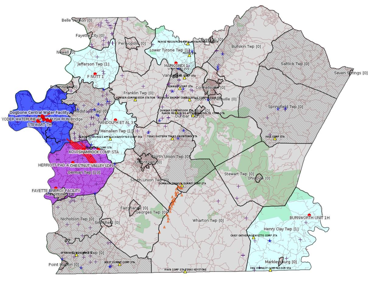
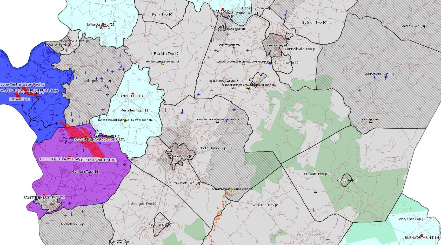
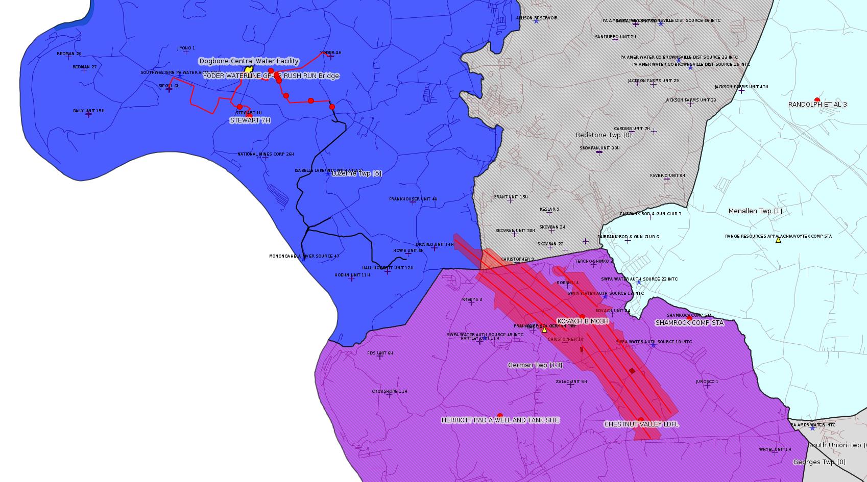
Map
Key
Red dots: items in this permit list with an exact location.
Blue stars: Marcellus Gas Well Water Sources.
Municipality shading: number of "facilities", with each well counting separately
(includes the red dots):
Red dots: items in this permit list with an exact location.
Blue stars: Marcellus Gas Well Water Sources.
Municipality shading: number of "facilities", with each well counting separately
(includes the red dots):
gray: 0
pale turquoise: 1
turquoise: 2
pale blue: 3
middle blue: 4
dark blue: 5
dark purple: 9
purple: 13
(Color coding may differ from one issue to the next.)
(Note if a project spans multiple municipalities -- e.g. a pipeline -- it will show in the count for each municipality.)
The number of facilities also follows the municipality name in brackets.
Municipality counts are based on the way the permit is listed by DEP; DEP has been known to get a municipality wrong.
Locations in brackets identify a precise location used to locate a surrogate for the actual site being permitted (e.g. locating a well pad or pipeline by the known location of a well.) Locations labeled beginning with "~" and ending in "[?]" are approximate and speculative based on inferences using on-line property and lease records. These are marked in the text as "[Approximate, Speculative]
Cross-hatching: Environmental Justice Areas
Yellow triangles: Compressor Stations
Orange triangles: Storage Field Wells (currently Dominion North Summit Storage Field)
Crosses: SPUD Unconventional well permits
Green: "Natural areas", e.g. state game lands, state forests
Yellow triangles: Compressor Stations
Orange triangles: Storage Field Wells (currently Dominion North Summit Storage Field)
Crosses: SPUD Unconventional well permits
Green: "Natural areas", e.g. state game lands, state forests
More Maps
 |
 |
Source: Pennsylvania Bulletin
Rescission of Technical Guidance
DEP ID: 550-0800-001. Title: Pennsylvania's Plan for Addressing Problem Abandoned Wells and Orphaned Wells. Description: The Department is rescinding this technical guidance document because it contains dated information. Funding sources, risk-based well scoring criteria, abandoned and orphan well inventories, and completed projects and associated costs have significantly changed since this document was last revised in 2000.
<https://www.pabulletin.com/secure/data/vol48/48-35/1363.html>
---
26-00588A: Laurel Mountain Midstream Operating, LLC (1550 Coraopolis Heights Road, Suite 140, Moon Township, PA 15108) Extension effective August 28, 2017, to extend the period of temporary operation of the new dehydrator and emergency generator authorized under plan approval PA-26-00588A at Shamrock Compressor Station located in German Township, Fayette County. One Solar Titan 130 turbine rated at 19,553 HP and originally authorized to be installed at this facility under PA-26-00588A is no longer authorized as the 18-month period to commence construction specified under 25 Pa. Code § 127.13(b) has passed.
<https://www.pabulletin.com/secure/data/vol48/48-36/1405c.html>
Location: 39.918333,-79.825 <http://osm.org/go/ZWpasXGm--?m=>
Parcel ID: 15140026
-------------------------
Source: eNOTICE (+ PA Oil and Gas Mapping, Well Pad Report.) Well Details via Data Portal Services: Oil and Gas Wells All (ID: 3).
Please see the Disclaimer below regarding Parcel Id data.
New:
Authorization ID: 1243124
Permit number: 051-21618
Site: RANDOLPH ET AL 3 OG WELL
Client: RANGE RESOURCES APPALACHIA LLC
Authorization type: Well Plugging Notice Alternate Method
Application type: New
Authorization is for: FACILITY
Date received: 08/31/2018
Status: Pending
Permit Decision Guarantee Applies?: No
Sub-Facilities for Authorization:
Sub-Facility ID Sub-Facility Name Description
758003 RANDOLPH ET AL 3 Well
Permit Review Notes:
Date Review Note
9/4/2018 The permit application package is complete, has been accepted, and is undergoing technical review.
<https://www.ahs.dep.pa.gov/eFACTSWeb/searchResults_singleAuth.aspx?AuthID=1243124>
Site Programs:
Oil & Gas
Site Municipalities:
Menallen Twp, Fayette County
Well Details:
Permit Number: 051-21618
Well Name: RANDOLPH ET AL 3
Unconventional Well: N
Well Configuration: Vertical Well
Well Type: GAS
Well Status: Active
Coal Association: Coal
Conservation Well: N
Primary Facility ID: 631098
Site ID: 607330
Site Name: RANDOLPH ET AL 3 OG WELL
Well Pad ID: 0
Well Pad Name:
Storage Field:
Operator: RANGE RESOURCES APPALACHIA LLC
Operator Number: OGO-60915
Permit Date: 2002-12-06
Permit Date Expires: 2003-12-06
SPUD Date: 2002-12-11
Date Plugged:
UIC ID:
UIC Type:
Surface Elevation: 1035
County: Fayette
Municipality: Menallen Twp
Location: 39.964748,-79.788649
Map URL: <http://www.openstreetmap.org/?mlat=39.964748&mlon=-79.788649#map=15/39.964748/-79.788649>
Presumed Parcel Id: 22060031
[See Notes.]
New:
Authorization ID: 1243116
Permit number: 051-21618
Site: RANDOLPH ET AL 3 OG WELL
Client: RANGE RESOURCES APPALACHIA LLC
Authorization type: Well Plugging Notice Intent to Plug Single Well
Application type: New
Authorization is for: FACILITY
Date received: 08/31/2018
Status: Issued on 9/4/2018
Permit Decision Guarantee Applies?: No
Sub-Facilities for Authorization:
Sub-Facility ID Sub-Facility Name Description
758003 RANDOLPH ET AL 3 Well
Permit Review Notes:
Date Review Note
9/4/2018 The technical review and decision review are complete and either the permit decision and/or permit issuance are forthcoming.
9/4/2018 The permit application package is complete, has been accepted, and is undergoing technical review.
<https://www.ahs.dep.pa.gov/eFACTSWeb/searchResults_singleAuth.aspx?AuthID=1243116>
Site Programs:
Oil & Gas
Site Municipalities:
Menallen Twp, Fayette County
Well Details:
Permit Number: 051-21618
Well Name: RANDOLPH ET AL 3
Unconventional Well: N
Well Configuration: Vertical Well
Well Type: GAS
Well Status: Active
Coal Association: Coal
Conservation Well: N
Primary Facility ID: 631098
Site ID: 607330
Site Name: RANDOLPH ET AL 3 OG WELL
Well Pad ID: 0
Well Pad Name:
Storage Field:
Operator: RANGE RESOURCES APPALACHIA LLC
Operator Number: OGO-60915
Permit Date: 2002-12-06
Permit Date Expires: 2003-12-06
SPUD Date: 2002-12-11
Date Plugged:
UIC ID:
UIC Type:
Surface Elevation: 1035
County: Fayette
Municipality: Menallen Twp
Location: 39.964748,-79.788649
Map URL: <http://www.openstreetmap.org/?mlat=39.964748&mlon=-79.788649#map=15/39.964748/-79.788649>
New:
Authorization ID: 1241754
Permit number: 051-21434
Site: MARICONDI 1 OG WELL
Client: RANGE RESOURCES APPALACHIA LLC
Authorization type: Well Plugging Notice Alternate Method
Application type: New
Authorization is for: FACILITY
Date received: 08/23/2018
Status: Issued on 8/30/2018
Permit Decision Guarantee Applies?: No
Sub-Facilities for Authorization:
Sub-Facility ID Sub-Facility Name Description
569358 MARICONDI 1 Well
Permit Review Notes:
Date Review Note
8/30/2018 The technical review and decision review are complete and either the permit decision and/or permit issuance are forthcoming.
8/23/2018 The permit application package is complete, has been accepted, and is undergoing technical review.
<https://www.ahs.dep.pa.gov/eFACTSWeb/searchResults_singleAuth.aspx?AuthID=1241754>
Site Programs:
Oil & Gas
Site Municipalities:
Lower Tyrone Twp, Fayette County
Well Details:
Permit Number: 051-21434
Well Name: MARICONDI 1
Unconventional Well: N
Well Configuration: Vertical Well
Well Type: GAS
Well Status: Active
Coal Association: NonCoal
Conservation Well: N
Primary Facility ID: 571234
Site ID: 555332
Site Name: MARICONDI 1 OG WELL
Well Pad ID: 0
Well Pad Name:
Storage Field:
Operator: RANGE RESOURCES APPALACHIA LLC
Operator Number: OGO-60915
Permit Date: 2002-02-13
Permit Date Expires: 2003-02-13
SPUD Date: 2002-02-21
Date Plugged:
UIC ID:
UIC Type:
Surface Elevation: 975
County: Fayette
Municipality: Lower Tyrone Twp
Location: 40.05393,-79.661847
Map URL: <http://www.openstreetmap.org/?mlat=40.05393&mlon=-79.661847#map=15/40.05393/-79.661847>
Presumed Parcel Id: 18080076
New:
Authorization ID: 1241684
Permit number: 051-24639
Site: STEWART WELL SITE ESCGP-2 EXPEDITED
Client: CHEVRON APPALACHIA LLC
Authorization type: Well Plugging Notice Intent to Plug Single Well
Application type: New
Authorization is for: FACILITY
Date received: 08/16/2018
Status: Pending
Permit Decision Guarantee Applies?: No
Sub-Facilities for Authorization:
Sub-Facility ID Sub-Facility Name Description
1246056 WELLBORE SURFACE HOLE LOCATION Well
Permit Review Notes:
Date Review Note
8/16/2018 The permit application package is complete, has been accepted, and is undergoing technical review.
<https://www.ahs.dep.pa.gov/eFACTSWeb/searchResults_singleAuth.aspx?AuthID=1241684>
Site Programs:
Oil & Gas
Site Municipalities:
Luzerne Twp, Fayette County
Well Details:
Permit Number: 051-24639
Well Name: STEWART 7H
Unconventional Well: Y
Well Configuration: Horizontal Well
Well Type: GAS
Well Status: Active
Coal Association: Coal
Conservation Well: N
Primary Facility ID: 822072
Site ID: 788124
Site Name: STEWART WELL SITE ESCGP-2 EXPEDITED
Well Pad ID: 152396
Well Pad Name: STEWART
Storage Field:
Operator: CHEVRON APPALACHIA LLC
Operator Number: OGO-39307
Permit Date: 2018-01-26
Permit Date Expires: 2019-01-26
SPUD Date: 2018-07-31
Date Plugged:
UIC ID:
UIC Type:
Surface Elevation: 1140
County: Fayette
Municipality: Luzerne Twp
Location: 39.962917,-79.946617
Map URL: <http://www.openstreetmap.org/?mlat=39.962917&mlon=-79.946617#map=15/39.962917/-79.946617>
Presumed Property Id: 19250010
[See Notes.]
OG WELLS PERMIT DOCS:
2018-01-26: Other Permit Documents, Name: Approval of Surface Locations by Landowners (for Authorization: 1203103):
<http://www.depgis.state.pa.us/pdfHandler/pdFHandler.ashx?Doc=NTQ5NzEz&ext=PDF>
2018-01-26: Final Permit Documents, Name: 1203103 (for Authorization: 1203103):
<http://www.depgis.state.pa.us/pdfHandler/pdFHandler.ashx?Doc=NTUxMTMw&ext=PDF>
2018-01-17: Other Permit Documents, Name: 051-24639 Alt Method (for Authorization: 1212314):
<http://www.depgis.state.pa.us/pdfHandler/pdFHandler.ashx?Doc=NTQ2MTgw&ext=PDF>
Electronically Submitted Records:
2018-01-26: Submission for Authorization 1203103
Pennsylvania Natural Diversity Inventory Form: Stewart Pad A PNDI 8-22-17.pdf
<http://www.depgis.state.pa.us/eWellDocHandler/pdFHandler.ashx?Doc=MzcwNTYy&ext=PDF>
Location Plat: Stewart Well Plats 7H.dwg
<http://www.depgis.state.pa.us/eWellDocHandler/pdFHandler.ashx?Doc=MzkxMTE3&ext=PDF>
Coal and Gas Resource Coord Act - Section 7 Exception: Stewart 1H-7H Waiver Request Section 7.pdf
<http://www.depgis.state.pa.us/eWellDocHandler/pdFHandler.ashx?Doc=MzkxMTE4&ext=PDF>
Well Cross-Section Diagram: Stewart 7H Page 4.pdf
<http://www.depgis.state.pa.us/eWellDocHandler/pdFHandler.ashx?Doc=MzkxMTE5&ext=PDF>
Well Permit Application - Coal Module: Stewart 1H-7H 2017 Coal Module.pdf
<http://www.depgis.state.pa.us/eWellDocHandler/pdFHandler.ashx?Doc=MzkxMTIw&ext=PDF>
Interested Party Notification: Stewart 1H-7H Affidavit of Non-Delivery.pdf
<http://www.depgis.state.pa.us/eWellDocHandler/pdFHandler.ashx?Doc=MzkxMTI5&ext=PDF>
Interested Party Notification: Stewart 1H-7H Affidavit of Non-Delivery.pdf
<http://www.depgis.state.pa.us/eWellDocHandler/pdFHandler.ashx?Doc=MzkxMTM4&ext=PDF>
Interested Party Notification: Stewart 1H-7H Affidavit of Non-Delivery.pdf
<http://www.depgis.state.pa.us/eWellDocHandler/pdFHandler.ashx?Doc=MzkxMTM5&ext=PDF>
Interested Party Notification: Stewart 1H-7H Affidavit of Non-Delivery.pdf
<http://www.depgis.state.pa.us/eWellDocHandler/pdFHandler.ashx?Doc=MzkxMTQw&ext=PDF>
Interested Party Notification: Stewart 1H-7H Affidavit of Non-Delivery.pdf
<http://www.depgis.state.pa.us/eWellDocHandler/pdFHandler.ashx?Doc=MzkxMTQx&ext=PDF>
Interested Party Notification: Stewart 1H-7H Affidavit of Non-Delivery.pdf
<http://www.depgis.state.pa.us/eWellDocHandler/pdFHandler.ashx?Doc=MzkxMTQ2&ext=PDF>
Permit Application to Drill and Operate a Well: 1609175.pdf
<http://www.depgis.state.pa.us/eWellDocHandler/pdFHandler.ashx?Doc=MzkyODA2&ext=PDF>
Authorization ID: 1240755
Permit number: 051-24670
Site: KOVACH B WELL SITE AND TANK SITE ESCGP ESX17-051-0003
Client: CHEVRON APPALACHIA LLC
Authorization type: Alt Method of Equipping, Casing, or Venting Well
Application type: New
Authorization is for: FACILITY
Date received: 08/16/2018
Status: Issued on 8/30/2018
Permit Decision Guarantee Applies?: Yes
Permit Decision Guarantee status: ACTIVE
Sub-Facilities for Authorization:
Sub-Facility ID Sub-Facility Name Description
1263128 WELLBORE SURFACE HOLE LOCATION Well
Permit Review Notes:
Date Review Note
8/30/2018 The technical review and decision review are complete and either the permit decision and/or permit issuance are forthcoming.
8/21/2018 The permit application package is complete, has been accepted, and is undergoing technical review.
<https://www.ahs.dep.pa.gov/eFACTSWeb/searchResults_singleAuth.aspx?AuthID=1240755>
Site Programs:
Oil & Gas
Site Municipalities:
German Twp [an Environmental Justice Area], Fayette County
Well Details:
Permit Number: 051-24670
Well Name: KOVACH B M09H
Unconventional Well: Y
Well Configuration: Horizontal Well
Well Type: GAS
Well Status: Active
Coal Association: Coal
Conservation Well: N
Primary Facility ID: 828036
Site ID: 826949
Site Name: KOVACH B WELL SITE AND TANK SITE ESCGP ESX17-051-0003
Well Pad ID: 155005
Well Pad Name: KOVACH B
Storage Field:
Operator: CHEVRON APPALACHIA LLC
Operator Number: OGO-39307
Permit Date: 2018-08-08
Permit Date Expires: 2019-08-08
SPUD Date:
Date Plugged:
UIC ID:
UIC Type:
Surface Elevation: 1278
County: Fayette
Municipality: German Twp
Location: 39.919231,-79.854758
Map URL: <http://www.openstreetmap.org/?mlat=39.919231&mlon=-79.854758#map=15/39.919231/-79.854758>
OG WELLS PERMIT DOCS:
2018-08-08: Final Permit Documents, Name: 1237726 (for Authorization: 1237726):
<http://www.depgis.state.pa.us/pdfHandler/pdFHandler.ashx?Doc=NjQ2Nzc1&ext=PDF>
Electronically Submitted Records:
2018-08-08: Submission for Authorization 1237726
Interested Party Notification: Kovach B Affidavit of Non-Delivery Venere.pdf
<http://www.depgis.state.pa.us/eWellDocHandler/pdFHandler.ashx?Doc=NjAyNjM1&ext=PDF>
Coal and Gas Resource Coord Act - Section 7 Exception: Kovach B Horizontals Section 7 Exception.pdf
<http://www.depgis.state.pa.us/eWellDocHandler/pdFHandler.ashx?Doc=NjAyNjQw&ext=PDF>
Pennsylvania Natural Diversity Inventory Form: Kovach B PNDI.pdf
<http://www.depgis.state.pa.us/eWellDocHandler/pdFHandler.ashx?Doc=NjAyNjQx&ext=PDF>
Location Plat: Kovach B M09H Plat.dwg
<http://www.depgis.state.pa.us/eWellDocHandler/pdFHandler.ashx?Doc=NjAyNjQy&ext=PDF>
Well Cross-Section Diagram: Kovach B M09H Page 4.pdf
<http://www.depgis.state.pa.us/eWellDocHandler/pdFHandler.ashx?Doc=NjAyNjQz&ext=PDF>
Permit Application to Drill and Operate a Well: 1753557.pdf
<http://www.depgis.state.pa.us/eWellDocHandler/pdFHandler.ashx?Doc=NjAzODg3&ext=PDF>
Authorization ID: 1240734
Permit number: 051-24669
Site: KOVACH B WELL SITE AND TANK SITE ESCGP ESX17-051-0003
Client: CHEVRON APPALACHIA LLC
Authorization type: Alt Method of Equipping, Casing, or Venting Well
Application type: New
Authorization is for: FACILITY
Date received: 08/16/2018
Status: Issued on 8/30/2018
Permit Decision Guarantee Applies?: Yes
Permit Decision Guarantee status: ACTIVE
Sub-Facilities for Authorization:
Sub-Facility ID Sub-Facility Name Description
1263127 WELLBORE SURFACE HOLE LOCATION Well
Permit Review Notes:
Date Review Note
8/30/2018 The technical review and decision review are complete and either the permit decision and/or permit issuance are forthcoming.
8/21/2018 The permit application package is complete, has been accepted, and is undergoing technical review.
<https://www.ahs.dep.pa.gov/eFACTSWeb/searchResults_singleAuth.aspx?AuthID=1240734>
Site Programs:
Oil & Gas
Site Municipalities:
German Twp [an Environmental Justice Area], Fayette County
Well Details:
Permit Number: 051-24669
Well Name: KOVACH B M08H
Unconventional Well: Y
Well Configuration: Horizontal Well
Well Type: GAS
Well Status: Active
Coal Association: Coal
Conservation Well: N
Primary Facility ID: 828035
Site ID: 826949
Site Name: KOVACH B WELL SITE AND TANK SITE ESCGP ESX17-051-0003
Well Pad ID: 155005
Well Pad Name: KOVACH B
Storage Field:
Operator: CHEVRON APPALACHIA LLC
Operator Number: OGO-39307
Permit Date: 2018-08-08
Permit Date Expires: 2019-08-08
SPUD Date:
Date Plugged:
UIC ID:
UIC Type:
Surface Elevation: 1278
County: Fayette
Municipality: German Twp
Location: 39.919197,-79.854658
Map URL: <http://www.openstreetmap.org/?mlat=39.919197&mlon=-79.854658#map=15/39.919197/-79.854658>
OG WELLS PERMIT DOCS:
2018-08-08: Final Permit Documents, Name: 1237725 (for Authorization: 1237725):
<http://www.depgis.state.pa.us/pdfHandler/pdFHandler.ashx?Doc=NjQ2Nzc0&ext=PDF>
Electronically Submitted Records:
2018-08-08: Submission for Authorization 1237725
Interested Party Notification: Kovach B Affidavit of Non-Delivery Venere.pdf
<http://www.depgis.state.pa.us/eWellDocHandler/pdFHandler.ashx?Doc=NjAyNjA5&ext=PDF>
Coal and Gas Resource Coord Act - Section 7 Exception: Kovach B Horizontals Section 7 Exception.pdf
<http://www.depgis.state.pa.us/eWellDocHandler/pdFHandler.ashx?Doc=NjAyNjE1&ext=PDF>
Pennsylvania Natural Diversity Inventory Form: Kovach B PNDI.pdf
<http://www.depgis.state.pa.us/eWellDocHandler/pdFHandler.ashx?Doc=NjAyNjE2&ext=PDF>
Location Plat: Kovach B M08H Plat.dwg
<http://www.depgis.state.pa.us/eWellDocHandler/pdFHandler.ashx?Doc=NjAyNjE3&ext=PDF>
Well Cross-Section Diagram: Kovach B M08H Page 4.pdf
<http://www.depgis.state.pa.us/eWellDocHandler/pdFHandler.ashx?Doc=NjAyNjE4&ext=PDF>
Permit Application to Drill and Operate a Well: 1753555.pdf
<http://www.depgis.state.pa.us/eWellDocHandler/pdFHandler.ashx?Doc=NjAzODgz&ext=PDF>
Authorization ID: 1240732
Permit number: 051-24668
Site: KOVACH B WELL SITE AND TANK SITE ESCGP ESX17-051-0003
Client: CHEVRON APPALACHIA LLC
Authorization type: Alt Method of Equipping, Casing, or Venting Well
Application type: New
Authorization is for: FACILITY
Date received: 08/16/2018
Status: Issued on 8/30/2018
Permit Decision Guarantee Applies?: Yes
Permit Decision Guarantee status: ACTIVE
Sub-Facilities for Authorization:
Sub-Facility ID Sub-Facility Name Description
1263126 WELLBORE SURFACE HOLE LOCATION Well
Permit Review Notes:
Date Review Note
8/30/2018 The technical review and decision review are complete and either the permit decision and/or permit issuance are forthcoming.
8/21/2018 The permit application package is complete, has been accepted, and is undergoing technical review.
<https://www.ahs.dep.pa.gov/eFACTSWeb/searchResults_singleAuth.aspx?AuthID=1240732>
Site Programs:
Oil & Gas
Site Municipalities:
German Twp [an Environmental Justice Area], Fayette County
Well Details:
Permit Number: 051-24668
Well Name: KOVACH B M07H
Unconventional Well: Y
Well Configuration: Horizontal Well
Well Type: GAS
Well Status: Active
Coal Association: Coal
Conservation Well: N
Primary Facility ID: 828034
Site ID: 826949
Site Name: KOVACH B WELL SITE AND TANK SITE ESCGP ESX17-051-0003
Well Pad ID: 155005
Well Pad Name: KOVACH B
Storage Field:
Operator: CHEVRON APPALACHIA LLC
Operator Number: OGO-39307
Permit Date: 2018-08-08
Permit Date Expires: 2019-08-08
SPUD Date:
Date Plugged:
UIC ID:
UIC Type:
Surface Elevation: 1278
County: Fayette
Municipality: German Twp
Location: 39.919161,-79.854681
Map URL: <http://www.openstreetmap.org/?mlat=39.919161&mlon=-79.854681#map=15/39.919161/-79.854681>
OG WELLS PERMIT DOCS:
2018-08-08: Final Permit Documents, Name: 1237724 (for Authorization: 1237724):
<http://www.depgis.state.pa.us/pdfHandler/pdFHandler.ashx?Doc=NjQ2Nzcz&ext=PDF>
Electronically Submitted Records:
2018-08-08: Submission for Authorization 1237724
Interested Party Notification: Kovach B Affidavit of Non-Delivery Venere.pdf
<http://www.depgis.state.pa.us/eWellDocHandler/pdFHandler.ashx?Doc=NjAyNTUw&ext=PDF>
Coal and Gas Resource Coord Act - Section 7 Exception: Kovach B Horizontals Section 7 Exception.pdf
<http://www.depgis.state.pa.us/eWellDocHandler/pdFHandler.ashx?Doc=NjAyNTY1&ext=PDF>
Pennsylvania Natural Diversity Inventory Form: Kovach B PNDI.pdf
<http://www.depgis.state.pa.us/eWellDocHandler/pdFHandler.ashx?Doc=NjAyNTY2&ext=PDF>
Location Plat: Kovach B M07H Plat.dwg
<http://www.depgis.state.pa.us/eWellDocHandler/pdFHandler.ashx?Doc=NjAyNTY3&ext=PDF>
Well Cross-Section Diagram: Kovach B M07H Page 4.pdf
<http://www.depgis.state.pa.us/eWellDocHandler/pdFHandler.ashx?Doc=NjAyNTY4&ext=PDF>
Permit Application to Drill and Operate a Well: 1753553.pdf
<http://www.depgis.state.pa.us/eWellDocHandler/pdFHandler.ashx?Doc=NjAzODcy&ext=PDF>
Authorization ID: 1240727
Permit number: 051-24673
Site: KOVACH B WELL SITE AND TANK SITE ESCGP ESX17-051-0003
Client: CHEVRON APPALACHIA LLC
Authorization type: Alt Method of Equipping, Casing, or Venting Well
Application type: New
Authorization is for: FACILITY
Date received: 08/16/2018
Status: Issued on 8/30/2018
Permit Decision Guarantee Applies?: Yes
Permit Decision Guarantee status: ACTIVE
Sub-Facilities for Authorization:
Sub-Facility ID Sub-Facility Name Description
1263131 WELLBORE SURFACE HOLE LOCATION Well
Permit Review Notes:
Date Review Note
8/30/2018 The technical review and decision review are complete and either the permit decision and/or permit issuance are forthcoming.
8/21/2018 The permit application package is complete, has been accepted, and is undergoing technical review.
<https://www.ahs.dep.pa.gov/eFACTSWeb/searchResults_singleAuth.aspx?AuthID=1240727>
Site Programs:
Oil & Gas
Site Municipalities:
German Twp [an Environmental Justice Area], Fayette County
Well Details:
Permit Number: 051-24673
Well Name: KOVACH B M06H
Unconventional Well: Y
Well Configuration: Horizontal Well
Well Type: GAS
Well Status: Active
Coal Association: Coal
Conservation Well: N
Primary Facility ID: 828039
Site ID: 826949
Site Name: KOVACH B WELL SITE AND TANK SITE ESCGP ESX17-051-0003
Well Pad ID: 155005
Well Pad Name: KOVACH B
Storage Field:
Operator: CHEVRON APPALACHIA LLC
Operator Number: OGO-39307
Permit Date: 2018-08-08
Permit Date Expires: 2019-08-08
SPUD Date:
Date Plugged:
UIC ID:
UIC Type:
Surface Elevation: 1278
County: Fayette
Municipality: German Twp
Location: 39.919122,-79.8547
Map URL: <http://www.openstreetmap.org/?mlat=39.919122&mlon=-79.8547#map=15/39.919122/-79.8547>
OG WELLS PERMIT DOCS:
2018-08-08: Final Permit Documents, Name: 1237729 (for Authorization: 1237729):
<http://www.depgis.state.pa.us/pdfHandler/pdFHandler.ashx?Doc=NjQ2Nzgx&ext=PDF>
Electronically Submitted Records:
2018-08-08: Submission for Authorization 1237729
Interested Party Notification: Kovach B Affidavit of Non-Delivery Venere.pdf
<http://www.depgis.state.pa.us/eWellDocHandler/pdFHandler.ashx?Doc=NjAyNTE3&ext=PDF>
Pennsylvania Natural Diversity Inventory Form: Kovach B PNDI.pdf
<http://www.depgis.state.pa.us/eWellDocHandler/pdFHandler.ashx?Doc=NjAyNTI1&ext=PDF>
Location Plat: Kovach B M06H Plat.dwg
<http://www.depgis.state.pa.us/eWellDocHandler/pdFHandler.ashx?Doc=NjAyNTI2&ext=PDF>
Coal and Gas Resource Coord Act - Section 7 Exception: Kovach B Horizontals Section 7 Exception.pdf
<http://www.depgis.state.pa.us/eWellDocHandler/pdFHandler.ashx?Doc=NjAyNTI3&ext=PDF>
Well Cross-Section Diagram: Kovach B M06H Page 4.pdf
<http://www.depgis.state.pa.us/eWellDocHandler/pdFHandler.ashx?Doc=NjAyNTI4&ext=PDF>
Permit Application to Drill and Operate a Well: 1753541.pdf
<http://www.depgis.state.pa.us/eWellDocHandler/pdFHandler.ashx?Doc=NjAzODY5&ext=PDF>
Authorization ID: 1240706
Permit number: 051-24667
Site: KOVACH B WELL SITE AND TANK SITE ESCGP ESX17-051-0003
Client: CHEVRON APPALACHIA LLC
Authorization type: Alt Method of Equipping, Casing, or Venting Well
Application type: New
Authorization is for: FACILITY
Date received: 08/16/2018
Status: Issued on 8/30/2018
Permit Decision Guarantee Applies?: Yes
Permit Decision Guarantee status: ACTIVE
Sub-Facilities for Authorization:
Sub-Facility ID Sub-Facility Name Description
1263125 WELLBORE SURFACE HOLE LOCATION Well
Permit Review Notes:
Date Review Note
8/30/2018 The technical review and decision review are complete and either the permit decision and/or permit issuance are forthcoming.
8/21/2018 The permit application package is complete, has been accepted, and is undergoing technical review.
<https://www.ahs.dep.pa.gov/eFACTSWeb/searchResults_singleAuth.aspx?AuthID=1240706>
Site Programs:
Oil & Gas
Site Municipalities:
German Twp [an Environmental Justice Area], Fayette County
Well Details:
Permit Number: 051-24667
Well Name: KOVACH B M05H
Unconventional Well: Y
Well Configuration: Horizontal Well
Well Type: GAS
Well Status: Active
Coal Association: Coal
Conservation Well: N
Primary Facility ID: 828033
Site ID: 826949
Site Name: KOVACH B WELL SITE AND TANK SITE ESCGP ESX17-051-0003
Well Pad ID: 155005
Well Pad Name: KOVACH B
Storage Field:
Operator: CHEVRON APPALACHIA LLC
Operator Number: OGO-39307
Permit Date: 2018-08-08
Permit Date Expires: 2019-08-08
SPUD Date:
Date Plugged:
UIC ID:
UIC Type:
Surface Elevation: 1278
County: Fayette
Municipality: German Twp
Location: 39.919086,-79.854722
Map URL: <http://www.openstreetmap.org/?mlat=39.919086&mlon=-79.854722#map=15/39.919086/-79.854722>
OG WELLS PERMIT DOCS:
2018-08-08: Final Permit Documents, Name: 1237723 (for Authorization: 1237723):
<http://www.depgis.state.pa.us/pdfHandler/pdFHandler.ashx?Doc=NjQ2Nzcw&ext=PDF>
Electronically Submitted Records:
2018-08-08: Submission for Authorization 1237723
Interested Party Notification: Kovach B Affidavit of Non-Delivery Venere.pdf
<http://www.depgis.state.pa.us/eWellDocHandler/pdFHandler.ashx?Doc=NjAyNDYz&ext=PDF>
Pennsylvania Natural Diversity Inventory Form: Kovach B PNDI.pdf
<http://www.depgis.state.pa.us/eWellDocHandler/pdFHandler.ashx?Doc=NjAyNDY5&ext=PDF>
Location Plat: Kovach B M05H Plat.dwg
<http://www.depgis.state.pa.us/eWellDocHandler/pdFHandler.ashx?Doc=NjAyNDcw&ext=PDF>
Coal and Gas Resource Coord Act - Section 7 Exception: Kovach B Horizontals Section 7 Exception.pdf
<http://www.depgis.state.pa.us/eWellDocHandler/pdFHandler.ashx?Doc=NjAyNDcx&ext=PDF>
Well Cross-Section Diagram: Kovach B M05H Page 4.pdf
<http://www.depgis.state.pa.us/eWellDocHandler/pdFHandler.ashx?Doc=NjAyNDcy&ext=PDF>
Permit Application to Drill and Operate a Well: 1753273.pdf
<http://www.depgis.state.pa.us/eWellDocHandler/pdFHandler.ashx?Doc=NjAzODYx&ext=PDF>
Authorization ID: 1240701
Permit number: 051-24666
Site: KOVACH B WELL SITE AND TANK SITE ESCGP ESX17-051-0003
Client: CHEVRON APPALACHIA LLC
Authorization type: Alt Method of Equipping, Casing, or Venting Well
Application type: New
Authorization is for: FACILITY
Date received: 08/16/2018
Status: Issued on 8/30/2018
Permit Decision Guarantee Applies?: Yes
Permit Decision Guarantee status: ACTIVE
Sub-Facilities for Authorization:
Sub-Facility ID Sub-Facility Name Description
1263124 WELLBORE SURFACE HOLE LOCATION Well
Permit Review Notes:
Date Review Note
8/30/2018 The technical review and decision review are complete and either the permit decision and/or permit issuance are forthcoming.
8/21/2018 The permit application package is complete, has been accepted, and is undergoing technical review.
<https://www.ahs.dep.pa.gov/eFACTSWeb/searchResults_singleAuth.aspx?AuthID=1240701>
Site Programs:
Oil & Gas
Site Municipalities:
German Twp [an Environmental Justice Area], Fayette County
Well Details:
Permit Number: 051-24666
Well Name: KOVACH B M04H
Unconventional Well: Y
Well Configuration: Horizontal Well
Well Type: GAS
Well Status: Active
Coal Association: Coal
Conservation Well: N
Primary Facility ID: 828032
Site ID: 826949
Site Name: KOVACH B WELL SITE AND TANK SITE ESCGP ESX17-051-0003
Well Pad ID: 155005
Well Pad Name: KOVACH B
Storage Field:
Operator: CHEVRON APPALACHIA LLC
Operator Number: OGO-39307
Permit Date: 2018-08-08
Permit Date Expires: 2019-08-08
SPUD Date:
Date Plugged:
UIC ID:
UIC Type:
Surface Elevation: 1278
County: Fayette
Municipality: German Twp
Location: 39.919047,-79.854742
Map URL: <http://www.openstreetmap.org/?mlat=39.919047&mlon=-79.854742#map=15/39.919047/-79.854742>
OG WELLS PERMIT DOCS:
2018-08-08: Final Permit Documents, Name: 1237722 (for Authorization: 1237722):
<http://www.depgis.state.pa.us/pdfHandler/pdFHandler.ashx?Doc=NjQ2NzY1&ext=PDF>
Electronically Submitted Records:
2018-08-08: Submission for Authorization 1237722
Interested Party Notification: Kovach B Affidavit of Non-Delivery Venere.pdf
<http://www.depgis.state.pa.us/eWellDocHandler/pdFHandler.ashx?Doc=NjAyMDMz&ext=PDF>
Coal and Gas Resource Coord Act - Section 7 Exception: Kovach B Horizontals Section 7 Exception.pdf
<http://www.depgis.state.pa.us/eWellDocHandler/pdFHandler.ashx?Doc=NjAyMDQx&ext=PDF>
Pennsylvania Natural Diversity Inventory Form: Kovach B PNDI.pdf
<http://www.depgis.state.pa.us/eWellDocHandler/pdFHandler.ashx?Doc=NjAyMDQy&ext=PDF>
Location Plat: Kovach B M04H Plat.dwg
<http://www.depgis.state.pa.us/eWellDocHandler/pdFHandler.ashx?Doc=NjAyMDQz&ext=PDF>
Well Cross-Section Diagram: Kovach B M04H Page 4.pdf
<http://www.depgis.state.pa.us/eWellDocHandler/pdFHandler.ashx?Doc=NjAyMDQ0&ext=PDF>
Permit Application to Drill and Operate a Well: 1753263.pdf
<http://www.depgis.state.pa.us/eWellDocHandler/pdFHandler.ashx?Doc=NjAzODU0&ext=PDF>
Authorization ID: 1240685
Permit number: 051-24674
Site: KOVACH B WELL SITE AND TANK SITE ESCGP ESX17-051-0003
Client: CHEVRON APPALACHIA LLC
Authorization type: Alt Method of Equipping, Casing, or Venting Well
Application type: New
Authorization is for: FACILITY
Date received: 08/16/2018
Status: Issued on 8/30/2018
Permit Decision Guarantee Applies?: Yes
Permit Decision Guarantee status: ACTIVE
Sub-Facilities for Authorization:
Sub-Facility ID Sub-Facility Name Description
1263132 WELLBORE SURFACE HOLE LOCATION Well
Permit Review Notes:
Date Review Note
8/30/2018 The technical review and decision review are complete and either the permit decision and/or permit issuance are forthcoming.
8/21/2018 The permit application package is complete, has been accepted, and is undergoing technical review.
<https://www.ahs.dep.pa.gov/eFACTSWeb/searchResults_singleAuth.aspx?AuthID=1240685>
Site Programs:
Oil & Gas
Site Municipalities:
German Twp [an Environmental Justice Area], Fayette County
Well Details:
Permit Number: 051-24674
Well Name: KOVACH B M03H
Unconventional Well: Y
Well Configuration: Horizontal Well
Well Type: GAS
Well Status: Active
Coal Association: Coal
Conservation Well: N
Primary Facility ID: 828040
Site ID: 826949
Site Name: KOVACH B WELL SITE AND TANK SITE ESCGP ESX17-051-0003
Well Pad ID: 155005
Well Pad Name: KOVACH B
Storage Field:
Operator: CHEVRON APPALACHIA LLC
Operator Number: OGO-39307
Permit Date: 2018-08-08
Permit Date Expires: 2019-08-08
SPUD Date:
Date Plugged:
UIC ID:
UIC Type:
Surface Elevation: 1278
County: Fayette
Municipality: German Twp
Location: 39.919008,-79.854764
Map URL: <http://www.openstreetmap.org/?mlat=39.919008&mlon=-79.854764#map=15/39.919008/-79.854764>
Presumed Parcel Id: 1511002301
OG WELLS PERMIT DOCS:
2018-08-08: Final Permit Documents, Name: 1237730 (for Authorization: 1237730):
<http://www.depgis.state.pa.us/pdfHandler/pdFHandler.ashx?Doc=NjQ2Nzgz&ext=PDF>
Electronically Submitted Records:
2018-08-08: Submission for Authorization 1237730
Interested Party Notification: Kovach B Affidavit of Non-Delivery Venere.pdf
<http://www.depgis.state.pa.us/eWellDocHandler/pdFHandler.ashx?Doc=NjAxOTgy&ext=PDF>
Pennsylvania Natural Diversity Inventory Form: Kovach B PNDI.pdf
<http://www.depgis.state.pa.us/eWellDocHandler/pdFHandler.ashx?Doc=NjAyMDAy&ext=PDF>
Location Plat: Kovach B M03H Plat.dwg
<http://www.depgis.state.pa.us/eWellDocHandler/pdFHandler.ashx?Doc=NjAyMDAz&ext=PDF>
Coal and Gas Resource Coord Act - Section 7 Exception: Kovach B Horizontals Section 7 Exception.pdf
<http://www.depgis.state.pa.us/eWellDocHandler/pdFHandler.ashx?Doc=NjAyMDA0&ext=PDF>
Well Cross-Section Diagram: Kovach B M03H Page 4.pdf
<http://www.depgis.state.pa.us/eWellDocHandler/pdFHandler.ashx?Doc=NjAyMDA1&ext=PDF>
Permit Application to Drill and Operate a Well: 1753252.pdf
<http://www.depgis.state.pa.us/eWellDocHandler/pdFHandler.ashx?Doc=NjAzODM4&ext=PDF>
Authorization ID: 1240676
Permit number: 051-24672
Site: KOVACH B WELL SITE AND TANK SITE ESCGP ESX17-051-0003
Client: CHEVRON APPALACHIA LLC
Authorization type: Alt Method of Equipping, Casing, or Venting Well
Application type: New
Authorization is for: FACILITY
Date received: 08/16/2018
Status: Issued on 8/30/2018
Permit Decision Guarantee Applies?: Yes
Permit Decision Guarantee status: ACTIVE
Sub-Facilities for Authorization:
Sub-Facility ID Sub-Facility Name Description
1263130 WELLBORE SURFACE HOLE LOCATION Well
Permit Review Notes:
Date Review Note
8/30/2018 The technical review and decision review are complete and either the permit decision and/or permit issuance are forthcoming.
8/21/2018 The permit application package is complete, has been accepted, and is undergoing technical review.
<https://www.ahs.dep.pa.gov/eFACTSWeb/searchResults_singleAuth.aspx?AuthID=1240676>
Site Programs:
Oil & Gas
Site Municipalities:
German Twp [an Environmental Justice Area], Fayette County
Well Details:
Permit Number: 051-24672
Well Name: KOVACH B M02H
Unconventional Well: Y
Well Configuration: Horizontal Well
Well Type: GAS
Well Status: Active
Coal Association: Coal
Conservation Well: N
Primary Facility ID: 828038
Site ID: 826949
Site Name: KOVACH B WELL SITE AND TANK SITE ESCGP ESX17-051-0003
Well Pad ID: 155005
Well Pad Name: KOVACH B
Storage Field:
Operator: CHEVRON APPALACHIA LLC
Operator Number: OGO-39307
Permit Date: 2018-08-08
Permit Date Expires: 2019-08-08
SPUD Date:
Date Plugged:
UIC ID:
UIC Type:
Surface Elevation: 1278
County: Fayette
Municipality: German Twp
Location: 39.918972,-79.854786
Map URL: <http://www.openstreetmap.org/?mlat=39.918972&mlon=-79.854786#map=15/39.918972/-79.854786>
OG WELLS PERMIT DOCS:
2018-08-08: Final Permit Documents, Name: 1237728 (for Authorization: 1237728):
<http://www.depgis.state.pa.us/pdfHandler/pdFHandler.ashx?Doc=NjQ2Nzc4&ext=PDF>
Electronically Submitted Records:
2018-08-08: Submission for Authorization 1237728
Interested Party Notification: Kovach B Affidavit of Non-Delivery Venere.pdf
<http://www.depgis.state.pa.us/eWellDocHandler/pdFHandler.ashx?Doc=NjAxODc1&ext=PDF>
Pennsylvania Natural Diversity Inventory Form: Kovach B PNDI.pdf
<http://www.depgis.state.pa.us/eWellDocHandler/pdFHandler.ashx?Doc=NjAxODc5&ext=PDF>
Location Plat: Kovach B M02H Plat.dwg
<http://www.depgis.state.pa.us/eWellDocHandler/pdFHandler.ashx?Doc=NjAxODgw&ext=PDF>
Well Cross-Section Diagram: Kovach B M02H Page 4.pdf
<http://www.depgis.state.pa.us/eWellDocHandler/pdFHandler.ashx?Doc=NjAxODgy&ext=PDF>
Coal and Gas Resource Coord Act - Section 7 Exception: Kovach B Horizontals Section 7 Exception.pdf
<http://www.depgis.state.pa.us/eWellDocHandler/pdFHandler.ashx?Doc=NjAxODkz&ext=PDF>
Permit Application to Drill and Operate a Well: 1753234.pdf
<http://www.depgis.state.pa.us/eWellDocHandler/pdFHandler.ashx?Doc=NjAzODI3&ext=PDF>
Authorization ID: 1240662
Permit number: 051-24671
Site: KOVACH B WELL SITE AND TANK SITE ESCGP ESX17-051-0003
Client: CHEVRON APPALACHIA LLC
Authorization type: Alt Method of Equipping, Casing, or Venting Well
Application type: New
Authorization is for: FACILITY
Date received: 08/16/2018
Status: Issued on 8/30/2018
Permit Decision Guarantee Applies?: Yes
Permit Decision Guarantee status: ACTIVE
Sub-Facilities for Authorization:
Sub-Facility ID Sub-Facility Name Description
1263129 WELLBORE SURFACE HOLE LOCATION Well
Permit Review Notes:
Date Review Note
8/30/2018 The technical review and decision review are complete and either the permit decision and/or permit issuance are forthcoming.
8/21/2018 The permit application package is complete, has been accepted, and is undergoing technical review.
<https://www.ahs.dep.pa.gov/eFACTSWeb/searchResults_singleAuth.aspx?AuthID=1240662>
Site Programs:
Oil & Gas
Site Municipalities:
German Twp [an Environmental Justice Area], Fayette County
Well Details:
Permit Number: 051-24671
Well Name: KOVACH B M01H
Unconventional Well: Y
Well Configuration: Horizontal Well
Well Type: GAS
Well Status: Active
Coal Association: Coal
Conservation Well: N
Primary Facility ID: 828037
Site ID: 826949
Site Name: KOVACH B WELL SITE AND TANK SITE ESCGP ESX17-051-0003
Well Pad ID: 155005
Well Pad Name: KOVACH B
Storage Field:
Operator: CHEVRON APPALACHIA LLC
Operator Number: OGO-39307
Permit Date: 2018-08-08
Permit Date Expires: 2019-08-08
SPUD Date:
Date Plugged:
UIC ID:
UIC Type:
Surface Elevation: 1278
County: Fayette
Municipality: German Twp
Location: 39.918933,-79.854808
Map URL: <http://www.openstreetmap.org/?mlat=39.918933&mlon=-79.854808#map=15/39.918933/-79.854808>
OG WELLS PERMIT DOCS:
2018-08-08: Final Permit Documents, Name: 1237727 (for Authorization: 1237727):
<http://www.depgis.state.pa.us/pdfHandler/pdFHandler.ashx?Doc=NjQ2Nzc2&ext=PDF>
Electronically Submitted Records:
2018-08-08: Submission for Authorization 1237727
Pennsylvania Natural Diversity Inventory Form: Kovach B PNDI.pdf
<http://www.depgis.state.pa.us/eWellDocHandler/pdFHandler.ashx?Doc=NjAxNjky&ext=PDF>
Coal and Gas Resource Coord Act - Section 7 Exception: Kovach B Horizontals Section 7 Exception.pdf
<http://www.depgis.state.pa.us/eWellDocHandler/pdFHandler.ashx?Doc=NjAxNjkz&ext=PDF>
Well Cross-Section Diagram: Kovach B M01H Page 4.pdf
<http://www.depgis.state.pa.us/eWellDocHandler/pdFHandler.ashx?Doc=NjAxODA2&ext=PDF>
Interested Party Notification: Kovach B Affidavit of Non-Delivery Venere.pdf
<http://www.depgis.state.pa.us/eWellDocHandler/pdFHandler.ashx?Doc=NjAxODE4&ext=PDF>
Location Plat: Kovach B M01H Plat.dwg
<http://www.depgis.state.pa.us/eWellDocHandler/pdFHandler.ashx?Doc=NjAxODI5&ext=PDF>
Permit Application to Drill and Operate a Well: 1747807.pdf
<http://www.depgis.state.pa.us/eWellDocHandler/pdFHandler.ashx?Doc=NjAzODE3&ext=PDF>
Authorization ID: 1238521
Permit number: 26-00588
Site: SHAMROCK COMP STA
Client: LAUREL MTN MIDSTREAM OPR LLC
Authorization type: Minor Facility Plan Approval New Source Performance Std
Application type: Extension
Authorization is for: FACILITY
Date received: 07/26/2018
Status: Issued on 8/27/2018
Permit Decision Guarantee Applies?: No
Sub-Facilities for Authorization:
Sub-Facility ID Sub-Facility Name Description
1020043 CATERPILLAR G3516B COMPRESSOR ENGINE #1 (1380 BHP) Process
Location: 39.918333,-79.825
Map URL: <http://www.openstreetmap.org/?mlat=39.918333&mlon=-79.825#map=15/39.918333/-79.825>
1020044 CATERPILLAR G3516B COMPRESSOR ENGINE #2 (1380 BHP) Process
Location: 39.918333,-79.825
Map URL: <http://www.openstreetmap.org/?mlat=39.918333&mlon=-79.825#map=15/39.918333/-79.825>
1020045 CATERPILLAR G3516B COMPRESSOR ENGINE #3 (1380 BHP) Process
Location: 39.918333,-79.825
Map URL: <http://www.openstreetmap.org/?mlat=39.918333&mlon=-79.825#map=15/39.918333/-79.825>
1024425 CATERPILLAR G3516B COMPRESSOR ENGINE #4 (1380 BHP) Process
Location: 39.918333,-79.825
Map URL: <http://www.openstreetmap.org/?mlat=39.918333&mlon=-79.825#map=15/39.918333/-79.825>
1024426 CATERPILLAR G3516B COMPRESSOR ENGINE #5 (1380 BHP) Process
Location: 39.918333,-79.825
Map URL: <http://www.openstreetmap.org/?mlat=39.918333&mlon=-79.825#map=15/39.918333/-79.825>
1024427 CATERPILLAR G3516B COMPRESSOR ENGINE #6 (1380 BHP) Process
Location: 39.918333,-79.825
Map URL: <http://www.openstreetmap.org/?mlat=39.918333&mlon=-79.825#map=15/39.918333/-79.825>
1024432 ENGINE #1 OXIDATION CATALYST Air Pollution Control Device
Location: 39.918333,-79.825
Map URL: <http://www.openstreetmap.org/?mlat=39.918333&mlon=-79.825#map=15/39.918333/-79.825>
1024434 ENGINE #2 OXIDATION CATALYST Air Pollution Control Device
Location: 39.918333,-79.825
Map URL: <http://www.openstreetmap.org/?mlat=39.918333&mlon=-79.825#map=15/39.918333/-79.825>
1024435 ENGINE #3 OXIDATION CATALYST Air Pollution Control Device
Location: 39.918333,-79.825
Map URL: <http://www.openstreetmap.org/?mlat=39.918333&mlon=-79.825#map=15/39.918333/-79.825>
1024436 ENGINE #4 OXIDATION CATALYST Air Pollution Control Device
Location: 39.918333,-79.825
Map URL: <http://www.openstreetmap.org/?mlat=39.918333&mlon=-79.825#map=15/39.918333/-79.825>
1024437 ENGINE #5 OXIDATION CATALYST Air Pollution Control Device
Location: 39.918333,-79.825
Map URL: <http://www.openstreetmap.org/?mlat=39.918333&mlon=-79.825#map=15/39.918333/-79.825>
1024438 ENGINE #6 OXIDATION CATALYST Air Pollution Control Device
Location: 39.918333,-79.825
Map URL: <http://www.openstreetmap.org/?mlat=39.918333&mlon=-79.825#map=15/39.918333/-79.825>
1024428 SOLAR MARS 100-16000S TURBINE (15,252 HP) Process
Location: 39.918333,-79.825
Map URL: <http://www.openstreetmap.org/?mlat=39.918333&mlon=-79.825#map=15/39.918333/-79.825>
1024431 TEG DEHYDRATOR 1 (200 MMSCF/DAY) Process
Location: 39.918333,-79.825
Map URL: <http://www.openstreetmap.org/?mlat=39.918333&mlon=-79.825#map=15/39.918333/-79.825>
Permit Review Notes:
Date Review Note
8/21/2018 The technical review and decision review are complete and either the permit decision and/or permit issuance are forthcoming.
8/21/2018 The permit application package is complete, has been accepted, and is undergoing technical review.
<https://www.ahs.dep.pa.gov/eFACTSWeb/searchResults_singleAuth.aspx?AuthID=1238521>
Site Programs:
Air Quality
Site Municipalities:
German Twp [an Environmental Justice Area], Fayette County
Authorization ID: 1238510
Permit number: 26-00535B
Site: FAYETTE ENERGY FACILITY
Client: DYNEGY FAYETTE II, LLC
Authorization type: Major Facility Plan Approval New Source Performance Std
Application type: Extension
Authorization is for: FACILITY
Date received: 07/24/2018
Status: Issued on 8/28/2018
Permit Decision Guarantee Applies?: No
Sub-Facilities for Authorization:
Sub-Facility ID Sub-Facility Name Description
805961 CGT STACK 1 Point of Air Emission
805962 CGT STACK 2 Point of Air Emission
805954 CGT TRAIN 1 COMBINED CYCLE TURBINE Process
805959 CGT TRAIN 2 COMBINED CYCLE TURBINE Process
1095705 OXIDATION CATALYST UNIT 1 Air Pollution Control Device
Location: 39.857408,-79.913878
Map URL: <http://www.openstreetmap.org/?mlat=39.857408&mlon=-79.913878#map=15/39.857408/-79.913878>
1095706 OXIDATION CATALYST UNIT 2 Air Pollution Control Device
Location: 39.857408,-79.913878
Map URL: <http://www.openstreetmap.org/?mlat=39.857408&mlon=-79.913878#map=15/39.857408/-79.913878>
1095701 SCR UNIT 1 Air Pollution Control Device
Location: 39.857408,-79.913878
Map URL: <http://www.openstreetmap.org/?mlat=39.857408&mlon=-79.913878#map=15/39.857408/-79.913878>
1095702 SCR UNIT 2 Air Pollution Control Device
Location: 39.857408,-79.913878
Map URL: <http://www.openstreetmap.org/?mlat=39.857408&mlon=-79.913878#map=15/39.857408/-79.913878>
Permit Review Notes:
Date Review Note
8/22/2018 The technical review and decision review are complete and either the permit decision and/or permit issuance are forthcoming.
8/22/2018 The permit application package is complete, has been accepted, and is undergoing technical review.
<https://www.ahs.dep.pa.gov/eFACTSWeb/searchResults_singleAuth.aspx?AuthID=1238510>
Site Programs:
Air Quality
Waste Management
Water Planning and Conservation
Site Municipalities:
German Twp [an Environmental Justice Area], Fayette County
Masontown Boro [Incorrect -jr], Fayette County
Presumed Parcel Id: 1530006703
Authorization ID: 1237070
Permit number: 051-24325
Site: BURNWORTH UNIT 1H OG WELL
Client: LPR ENERGY LLC
Authorization type: Drill & Operate Well Permit Inactive Status
Application type: New
Authorization is for: FACILITY
Date received: 06/29/2018
Status: Pending
Permit Decision Guarantee Applies?: No
Sub-Facilities for Authorization:
Sub-Facility ID Sub-Facility Name Description
1008212 BURNWORTH UNIT 1H Well
Permit Review Notes:
Date Review Note
7/20/2018 The permit application package is complete, has been accepted, and is undergoing technical review.
<https://www.ahs.dep.pa.gov/eFACTSWeb/searchResults_singleAuth.aspx?AuthID=1237070>
Site Programs:
Oil & Gas
Site Municipalities:
Henry Clay Twp, Fayette County
Well Details:
Permit Number: 051-24325
Well Name: BURNWORTH UNIT 1H
Unconventional Well: Y
Well Configuration: Horizontal Well
Well Type: GAS
Well Status: Regulatory Inactive Status
Coal Association: NonCoal
Conservation Well: N
Primary Facility ID: 727542
Site ID: 730706
Site Name: BURNWORTH UNIT 1H OG WELL
Well Pad ID: 146187
Well Pad Name: BURNWORTH UNIT 1H
Storage Field:
Operator: LPR ENERGY LLC
Operator Number: OGO-68579
Permit Date: 2010-03-05
Permit Date Expires: 2011-03-05
SPUD Date: 2010-05-10
Date Plugged:
UIC ID:
UIC Type:
Surface Elevation: 1890
County: Fayette
Municipality: Henry Clay Twp
Location: 39.808139,-79.390917
Map URL: <http://www.openstreetmap.org/?mlat=39.808139&mlon=-79.390917#map=15/39.808139/-79.390917>
Presumed Parcel Id: 16090033
Authorization ID: 1235970
Permit number: 100419
Site: CHESTNUT VALLEY LDFL
Client: ADVANCED DSPL SVC CHESTNUT VALLEY LDFL INC
Authorization type: Landfill Pmt Final Construction Certification Form 37
Application type: Modification
Authorization is for: FACILITY
Date received: 06/29/2018
Status: Issued on 8/24/2018
Permit Decision Guarantee Applies?: Yes
Permit Decision Guarantee status: VOID
Permit Review Notes:
Date Review Note
8/24/2018 The technical review and decision review are complete and either the permit decision and/or permit issuance are forthcoming.
8/8/2018 Applicant has been issued a deficiency letter. If applicable, this application no longer qualifies for the Permit Decision Guarantee.
7/19/2018 Applicant has been issued a deficiency letter. If applicable, this application no longer qualifies for the Permit Decision Guarantee.
7/19/2018 The permit application package is complete, has been accepted, and is undergoing technical review.
<https://www.ahs.dep.pa.gov/eFACTSWeb/searchResults_singleAuth.aspx?AuthID=1235970>
Site Programs:
Air Quality
Clean Water
Environmental Cleanup & Brownfields
Mining
Radiation Protection
Waste Management
Water Planning and Conservation
Site Municipalities:
German Twp [an Environmental Justice Area], Fayette County
Location: 39.896765,-79.838766 <http://osm.org/go/ZWpP0~XK--?m=>
Presumed Parcel Id: 15280012
Authorization ID: 1234130
Permit number: GP08260718002
Site: YODER WATERLINE GP5 & GP8
Client: CHEVRON APPALACHIA LLC
Authorization type: GP-08 Temporary Road Crossings
Application type: New
Authorization is for: FACILITY
Date received: 06/21/2018
Status: Pending
Permit Decision Guarantee Applies?: No
Sub-Facilities for Authorization:
Sub-Facility ID Sub-Facility Name Description
1264105 RUSH RUN Bridge
Location: 39.972594,-79.94053
Map URL: <http://www.openstreetmap.org/?mlat=39.972594&mlon=-79.94053#map=15/39.972594/-79.94053>
1261250 YODER WATERLINE GP08260718-002 Bridge
Permit Review Notes:
Date Review Note
6/28/2018 The permit application package is complete, has been accepted, and is undergoing technical review.
<https://www.ahs.dep.pa.gov/eFACTSWeb/searchResults_singleAuth.aspx?AuthID=1234130>
Site Programs:
Water Planning and Conservation
Site Municipalities:
Luzerne Twp, Fayette County
Authorization ID: 1226967
Permit number: ESX18-051-0002
Site: HERRIOTT PAD A WELL AND TANK SITE ESCGP ESX18-051-0002
Client: CHEVRON APPALACHIA LLC
Authorization type: Expedited E&S Stormwater General Permit 1
Application type: New
Authorization is for: SITE
Date received: 05/01/2018
Status: Pending
Permit Decision Guarantee Applies?: Yes
Permit Decision Guarantee status: VOID
Permit Review Notes:
Date Review Note
9/6/2018 Applicant has been issued a deficiency letter. If applicable, this application no longer qualifies for the Permit Decision Guarantee.
7/27/2018 Applicant has been issued a deficiency letter. If applicable, this application no longer qualifies for the Permit Decision Guarantee.
7/16/2018 Applicant has been issued a deficiency letter. If applicable, this application no longer qualifies for the Permit Decision Guarantee.
<https://www.ahs.dep.pa.gov/eFACTSWeb/searchResults_singleAuth.aspx?AuthID=1226967>
Site Programs:
Oil & Gas
Site Municipalities:
German Twp [an Environmental Justice Area], Fayette County
Well Pad ID: 155082
Location: 39.897981,-79.878003 <https://osm.org/go/ZWpPXJxr--?m=>
Wells on this Pad:
051-24649 HERRIOTT 1
Presumed Parcel Id: 15220125
Authorization ID: 1221795
Permit number: ESG18-051-0001
Site: DOGBONE WATER LINE ESCGP ESG18-051-0001
Client: CHEVRON APPALACHIA LLC
Authorization type: Erosion and Sediment Control GP-2
Application type: New
Authorization is for: SITE
Date received: 03/22/2018
Status: Pending
Permit Decision Guarantee Applies?: Yes
Permit Decision Guarantee status: VOID
Permit Review Notes:
Date Review Note
9/5/2018 The technical review and decision review are complete and either the permit decision and/or permit issuance are forthcoming.
8/23/2018 Applicant has been issued a deficiency letter. If applicable, this application no longer qualifies for the Permit Decision Guarantee.
7/11/2018 Applicant has been issued a deficiency letter. If applicable, this application no longer qualifies for the Permit Decision Guarantee.
6/15/2018 Applicant has been issued a deficiency letter. If applicable, this application no longer qualifies for the Permit Decision Guarantee.
<https://www.ahs.dep.pa.gov/eFACTSWeb/searchResults_singleAuth.aspx?AuthID=1221795>
Site Programs:
Site Municipalities:
Luzerne Twp, Fayette County
Authorization ID: 1219473
Permit number: GP08260718001
Site: DOGBONE WATER LINE SYSTEM GP5 & GP8
Client: CHEVRON APPALACHIA LLC
Authorization type: GP-08 Temporary Road Crossings
Application type: New
Authorization is for: FACILITY
Date received: 02/26/2018
Status: Pending
Permit Decision Guarantee Applies?: No
Sub-Facilities for Authorization:
Sub-Facility ID Sub-Facility Name Description
1255183 DOGBONE WATER LINE SYSTEM GP08260718-001 Bridge
1263383 RUSH RUN Bridge
Location: 39.972594,-79.94053
Map URL: <http://www.openstreetmap.org/?mlat=39.972594&mlon=-79.94053#map=15/39.972594/-79.94053>
1263344 UNT 1 TO RUSH RUN Bridge
Location: 39.966089,-79.929451
Map URL: <http://www.openstreetmap.org/?mlat=39.966089&mlon=-79.929451#map=15/39.966089/-79.929451>
1263387 UNT 11 TO MONONGAHELA RIVER Bridge
Location: 39.964927,-79.949358
Map URL: <http://www.openstreetmap.org/?mlat=39.964927&mlon=-79.949358#map=15/39.964927/-79.949358>
1263345 UNT 2 TO RUSH RUN Bridge
Location: 39.966133,-79.929546
Map URL: <http://www.openstreetmap.org/?mlat=39.966133&mlon=-79.929546#map=15/39.966133/-79.929546>
1263355 UNT 3 TO RUSH RUN Bridge
Location: 39.970406,-79.938318
Map URL: <http://www.openstreetmap.org/?mlat=39.970406&mlon=-79.938318#map=15/39.970406/-79.938318>
1263381 UNT 5 TO RUSH RUN Bridge
Location: 39.97171,-79.939012
Map URL: <http://www.openstreetmap.org/?mlat=39.97171&mlon=-79.939012#map=15/39.97171/-79.939012>
1263342 WETLAND 1 PEM Temporary Wetland Impact
Location: 39.964732,-79.923644
Map URL: <http://www.openstreetmap.org/?mlat=39.964732&mlon=-79.923644#map=15/39.964732/-79.923644>
1263341 WETLAND 1 PEM Bridge
Location: 39.964732,-79.923644
Map URL: <http://www.openstreetmap.org/?mlat=39.964732&mlon=-79.923644#map=15/39.964732/-79.923644>
1263349 WETLAND 2 PEM Bridge
Location: 39.966029,-79.929549
Map URL: <http://www.openstreetmap.org/?mlat=39.966029&mlon=-79.929549#map=15/39.966029/-79.929549>
1263350 WETLAND 2 PEM Temporary Wetland Impact
Location: 39.966029,-79.929549
Map URL: <http://www.openstreetmap.org/?mlat=39.966029&mlon=-79.929549#map=15/39.966029/-79.929549>
1263353 WETLAND 4 PEM Temporary Wetland Impact
Location: 39.967206,-79.936459
Map URL: <http://www.openstreetmap.org/?mlat=39.967206&mlon=-79.936459#map=15/39.967206/-79.936459>
1263352 WETLAND 4 PEM Bridge
Location: 39.967206,-79.936459
Map URL: <http://www.openstreetmap.org/?mlat=39.967206&mlon=-79.936459#map=15/39.967206/-79.936459>
1263362 WETLAND 6 Temporary Wetland Impact
Location: 39.970569,-79.93838
Map URL: <http://www.openstreetmap.org/?mlat=39.970569&mlon=-79.93838#map=15/39.970569/-79.93838>
1263356 WETLAND 6 PEM Bridge
Location: 39.970622,-79.938392
Map URL: <http://www.openstreetmap.org/?mlat=39.970622&mlon=-79.938392#map=15/39.970622/-79.938392>
1263361 WETLAND 6 PFO Bridge
Location: 39.970569,-79.93838
Map URL: <http://www.openstreetmap.org/?mlat=39.970569&mlon=-79.93838#map=15/39.970569/-79.93838>
1263371 WETLAND 7 PEM Temporary Wetland Impact
Location: 39.9713,-79.938846
Map URL: <http://www.openstreetmap.org/?mlat=39.9713&mlon=-79.938846#map=15/39.9713/-79.938846>
1263368 WETLAND 7 PEM Bridge
Location: 39.9713,-79.938846
Map URL: <http://www.openstreetmap.org/?mlat=39.9713&mlon=-79.938846#map=15/39.9713/-79.938846>
Permit Review Notes:
Date Review Note
5/2/2018 Applicant has been issued a deficiency letter. If applicable, this application no longer qualifies for the Permit Decision Guarantee.
4/20/2018 Applicant has been issued a deficiency letter. If applicable, this application no longer qualifies for the Permit Decision Guarantee.
<https://www.ahs.dep.pa.gov/eFACTSWeb/searchResults_singleAuth.aspx?AuthID=1219473>
Site Programs:
Water Planning and Conservation
Site Municipalities:
Luzerne Twp, Fayette County
Authorization ID: 1219469
Permit number: GP05260718001
Site: DOGBONE WATER LINE SYSTEM GP5 & GP8
Client: CHEVRON APPALACHIA LLC
Authorization type: GP-05 Utility Line Stream Crossings
Application type: New
Authorization is for: FACILITY
Date received: 02/26/2018
Status: Pending
Permit Decision Guarantee Applies?: Yes
Permit Decision Guarantee status: VOID
Sub-Facilities for Authorization:
Sub-Facility ID Sub-Facility Name Description
1263384 RUSH RUN Pipeline or Conduit
Location: 39.972594,-79.94053
Map URL: <http://www.openstreetmap.org/?mlat=39.972594&mlon=-79.94053#map=15/39.972594/-79.94053>
1263343 UNT 1 TO RUSH RUN Pipeline or Conduit
Location: 39.966089,-79.929451
Map URL: <http://www.openstreetmap.org/?mlat=39.966089&mlon=-79.929451#map=15/39.966089/-79.929451>
1263386 UNT 11 TO MONONGAHELA RIVER Pipeline or Conduit
Location: 39.964927,-79.949358
Map URL: <http://www.openstreetmap.org/?mlat=39.964927&mlon=-79.949358#map=15/39.964927/-79.949358>
1263346 UNT 2 TO RUSH RUN Pipeline or Conduit
Location: 39.966133,-79.929546
Map URL: <http://www.openstreetmap.org/?mlat=39.966133&mlon=-79.929546#map=15/39.966133/-79.929546>
1263354 UNT 3 TO RUSH RUN Pipeline or Conduit
Location: 39.970406,-79.938318
Map URL: <http://www.openstreetmap.org/?mlat=39.970406&mlon=-79.938318#map=15/39.970406/-79.938318>
1263374 UNT 5 TO RUSH RUN Pipeline or Conduit
Location: 39.97171,-79.939012
Map URL: <http://www.openstreetmap.org/?mlat=39.97171&mlon=-79.939012#map=15/39.97171/-79.939012>
1255180 WETLAND 1 PEM Pipeline or Conduit
Location: 39.964732,-79.923644
Map URL: <http://www.openstreetmap.org/?mlat=39.964732&mlon=-79.923644#map=15/39.964732/-79.923644>
1263342 WETLAND 1 PEM Temporary Wetland Impact
Location: 39.964732,-79.923644
Map URL: <http://www.openstreetmap.org/?mlat=39.964732&mlon=-79.923644#map=15/39.964732/-79.923644>
1263350 WETLAND 2 PEM Temporary Wetland Impact
Location: 39.966029,-79.929549
Map URL: <http://www.openstreetmap.org/?mlat=39.966029&mlon=-79.929549#map=15/39.966029/-79.929549>
1263353 WETLAND 4 PEM Temporary Wetland Impact
Location: 39.967206,-79.936459
Map URL: <http://www.openstreetmap.org/?mlat=39.967206&mlon=-79.936459#map=15/39.967206/-79.936459>
1263362 WETLAND 6 Temporary Wetland Impact
Location: 39.970569,-79.93838
Map URL: <http://www.openstreetmap.org/?mlat=39.970569&mlon=-79.93838#map=15/39.970569/-79.93838>
1263358 WETLAND 6 PFO Pipeline or Conduit
Location: 39.970569,-79.93838
Map URL: <http://www.openstreetmap.org/?mlat=39.970569&mlon=-79.93838#map=15/39.970569/-79.93838>
1263371 WETLAND 7 PEM Temporary Wetland Impact
Location: 39.9713,-79.938846
Map URL: <http://www.openstreetmap.org/?mlat=39.9713&mlon=-79.938846#map=15/39.9713/-79.938846>
1263366 WETLAND 7 PEM Pipeline or Conduit
Location: 39.9713,-79.938846
Map URL: <http://www.openstreetmap.org/?mlat=39.9713&mlon=-79.938846#map=15/39.9713/-79.938846>
Permit Review Notes:
Date Review Note
5/2/2018 Applicant has been issued a deficiency letter. If applicable, this application no longer qualifies for the Permit Decision Guarantee.
4/20/2018 Applicant has been issued a deficiency letter. If applicable, this application no longer qualifies for the Permit Decision Guarantee.
<https://www.ahs.dep.pa.gov/eFACTSWeb/searchResults_singleAuth.aspx?AuthID=1219469>
Site Programs:
Water Planning and Conservation
Site Municipalities:
Luzerne Twp, Fayette County
Authorization ID: 1187805
Permit number: PA0090948
Site: CHESTNUT VALLEY LDFL
Client: ADVANCED DSPL SVC CHESTNUT VALLEY LDFL INC
Authorization type: Minor IW Facility with ELG
Application type: Renewal
Authorization is for: FACILITY
Date received: 06/12/2017
Status: Issued on 9/4/2018
Permit Decision Guarantee Applies?: No
Sub-Facilities for Authorization:
Sub-Facility ID Sub-Facility Name Description
212046 OUTFALL 001 Discharge Point
Location: 39.902222,-79.835
Map URL: <http://www.openstreetmap.org/?mlat=39.902222&mlon=-79.835#map=15/39.902222/-79.835>
568839 OUTFALL 002 Discharge Point
Location: 39.896111,-79.836111
Map URL: <http://www.openstreetmap.org/?mlat=39.896111&mlon=-79.836111#map=15/39.896111/-79.836111>
568840 SW OUTFALL 003 Discharge Point
Location: 39.895833,-79.835833
Map URL: <http://www.openstreetmap.org/?mlat=39.895833&mlon=-79.835833#map=15/39.895833/-79.835833>
Permit Review Notes:
Date Review Note
8/31/2018 The technical review and decision review are complete and either the permit decision and/or permit issuance are forthcoming.
10/31/2017 The permit application package is complete, has been accepted, and is undergoing technical review.
<https://www.ahs.dep.pa.gov/eFACTSWeb/searchResults_singleAuth.aspx?AuthID=1187805>
Site Programs:
Air Quality
Clean Water
Environmental Cleanup & Brownfields
Mining
Radiation Protection
Waste Management
Water Planning and Conservation
Site Municipalities:
German Twp [an Environmental Justice Area], Fayette County
-------------------------
Source: DEP Oil and Gas Electronic Notifications
NOTIFICATION_ID: 43122
OGO: 39307
OPERATOR: CHEVRON APPALACHIA LLC
API_PERMIT: 051-24648
SPUD_DATE: 04/02/2018
COUNTY: Fayette
MUNICIPALITY: Luzerne
LATITUDE: 39.969036
LONGITUDE: -79.968861
SUBJECT: [NOTIFICATION]: Casing cementing notification 58 Pa. C.S. 3211(f)(2) for well API 37-051-24648-00-00
QUESTION: Enter the Date and Time for the applicable Casing Types
ANSWER: Intermediate: 8/29/2018 6:00:00 AM
SENT_DATE: 8/28/2018 5:57:45 AM
SENT_SUCCESS: Yes
LAST_RESENT_DATE:
RESENT_SUCCESS:
Well Details:
Permit Number: 051-24648
Well Name: SIEGEL 9H
Unconventional Well: Y
Well Configuration: Horizontal Well
Well Type: GAS
Well Status: Active
Coal Association: Coal
Conservation Well: N
Primary Facility ID: 823796
Site ID: 790384
Site Name: SIEGEL WELL PAD ESCGP-2 EXPEDITED
Well Pad ID: 152926
Well Pad Name: SIEGEL 1
Storage Field:
Operator: CHEVRON APPALACHIA LLC
Operator Number: OGO-39307
Permit Date: 2018-02-23
Permit Date Expires: 2019-02-23
SPUD Date: 2018-04-02
Date Plugged:
UIC ID:
UIC Type:
Surface Elevation: 1173
County: Fayette
Municipality: Luzerne Twp
Location: 39.969036,-79.968861
Map URL: <http://www.openstreetmap.org/?mlat=39.969036&mlon=-79.968861#map=15/39.969036/-79.968861>
OG WELLS PERMIT DOCS:
2018-02-27: Final Permit Documents, Name: 1212442 (for Authorization: 1212442):
<http://www.depgis.state.pa.us/pdfHandler/pdFHandler.ashx?Doc=NTY0ODc4&ext=PDF>
Electronically Submitted Records:
2018-02-27: Submission for Authorization 1212442
Interested Party Notification: Siegel Affidavit of Non-Delivery Foster.pdf
<http://www.depgis.state.pa.us/eWellDocHandler/pdFHandler.ashx?Doc=NDQ5MDY4&ext=PDF>
Interested Party Notification: Siegel Affidavit of Non-Delivery Foster.pdf
<http://www.depgis.state.pa.us/eWellDocHandler/pdFHandler.ashx?Doc=NDQ5MDY5&ext=PDF>
Interested Party Notification: Siegel Affidavit of Non-Delivery Foster.pdf
<http://www.depgis.state.pa.us/eWellDocHandler/pdFHandler.ashx?Doc=NDQ5MDcw&ext=PDF>
Interested Party Notification: Siegel Affidavit of Non-Delivery Foster.pdf
<http://www.depgis.state.pa.us/eWellDocHandler/pdFHandler.ashx?Doc=NDQ5MDcx&ext=PDF>
Interested Party Notification: Siegel Affidavit of Non-Delivery Foster.pdf
<http://www.depgis.state.pa.us/eWellDocHandler/pdFHandler.ashx?Doc=NDQ5MDcy&ext=PDF>
Interested Party Notification: Siegel Affidavit of Non-Delivery Foster.pdf
<http://www.depgis.state.pa.us/eWellDocHandler/pdFHandler.ashx?Doc=NDQ5MDcz&ext=PDF>
Interested Party Notification: Siegel Affidavit of Non-Delivery Foster.pdf
<http://www.depgis.state.pa.us/eWellDocHandler/pdFHandler.ashx?Doc=NDQ5MDc0&ext=PDF>
Interested Party Notification: Siegel Affidavit of Non-Delivery Franks.pdf
<http://www.depgis.state.pa.us/eWellDocHandler/pdFHandler.ashx?Doc=NDQ5MDc1&ext=PDF>
Interested Party Notification: Siegel Affidavit of Non-Delivery Franks.pdf
<http://www.depgis.state.pa.us/eWellDocHandler/pdFHandler.ashx?Doc=NDQ5MDc4&ext=PDF>
Location Plat: 143-781-Well Plat 9H-pages1-2-3_3702.dwg
<http://www.depgis.state.pa.us/eWellDocHandler/pdFHandler.ashx?Doc=NDQ5MDgy&ext=PDF>
Pennsylvania Natural Diversity Inventory Form: Siegel PNDI.pdf
<http://www.depgis.state.pa.us/eWellDocHandler/pdFHandler.ashx?Doc=NDQ5MDgz&ext=PDF>
Coal and Gas Resource Coord Act - Section 7 Exception: Siegel 1H-9H Waiver Request Section 7.pdf
<http://www.depgis.state.pa.us/eWellDocHandler/pdFHandler.ashx?Doc=NDQ5MDg0&ext=PDF>
Well Cross-Section Diagram: Siegel 9H Page 4.pdf
<http://www.depgis.state.pa.us/eWellDocHandler/pdFHandler.ashx?Doc=NDQ5MDg1&ext=PDF>
Permit Application to Drill and Operate a Well: 1640187.pdf
<http://www.depgis.state.pa.us/eWellDocHandler/pdFHandler.ashx?Doc=NDQ5ODMz&ext=PDF>
---
NOTIFICATION_ID: 43168
OGO: 39307
OPERATOR: CHEVRON APPALACHIA LLC
API_PERMIT: 051-24647
SPUD_DATE: 04/02/2018
COUNTY: Fayette
MUNICIPALITY: Luzerne
LATITUDE: 39.968997
LONGITUDE: -79.968928
SUBJECT: [NOTIFICATION]: Drilling resumption After Break of 30 days or more notification 58 Pa. C.S. 3211(f)(1) for well API 37-051-24647-00-00
QUESTION: Date and approximate time action is to occur
ANSWER: Date: 08/30/2018 Time: 12:00pm
SENT_DATE: 8/29/2018 10:07:00 AM
SENT_SUCCESS: Yes
LAST_RESENT_DATE:
RESENT_SUCCESS:
Well Details:
Permit Number: 051-24647
Well Name: SIEGEL 8H
Unconventional Well: Y
Well Configuration: Horizontal Well
Well Type: GAS
Well Status: Active
Coal Association: Coal
Conservation Well: N
Primary Facility ID: 823795
Site ID: 790384
Site Name: SIEGEL WELL PAD ESCGP-2 EXPEDITED
Well Pad ID: 152926
Well Pad Name: SIEGEL 1
Storage Field:
Operator: CHEVRON APPALACHIA LLC
Operator Number: OGO-39307
Permit Date: 2018-02-23
Permit Date Expires: 2019-02-23
SPUD Date: 2018-04-02
Date Plugged:
UIC ID:
UIC Type:
Surface Elevation: 1173
County: Fayette
Municipality: Luzerne Twp
Location: 39.968997,-79.968928
Map URL: <http://www.openstreetmap.org/?mlat=39.968997&mlon=-79.968928#map=15/39.968997/-79.968928>
OG WELLS PERMIT DOCS:
2018-02-27: Final Permit Documents, Name: 1212441 (for Authorization: 1212441):
<http://www.depgis.state.pa.us/pdfHandler/pdFHandler.ashx?Doc=NTY0ODc0&ext=PDF>
Electronically Submitted Records:
2018-02-27: Submission for Authorization 1212441
Interested Party Notification: Siegel Affidavit of Non-Delivery Foster.pdf
<http://www.depgis.state.pa.us/eWellDocHandler/pdFHandler.ashx?Doc=NDQ5MDQ0&ext=PDF>
Interested Party Notification: Siegel Affidavit of Non-Delivery Foster.pdf
<http://www.depgis.state.pa.us/eWellDocHandler/pdFHandler.ashx?Doc=NDQ5MDQ1&ext=PDF>
Interested Party Notification: Siegel Affidavit of Non-Delivery Foster.pdf
<http://www.depgis.state.pa.us/eWellDocHandler/pdFHandler.ashx?Doc=NDQ5MDQ2&ext=PDF>
Interested Party Notification: Siegel Affidavit of Non-Delivery Foster.pdf
<http://www.depgis.state.pa.us/eWellDocHandler/pdFHandler.ashx?Doc=NDQ5MDUw&ext=PDF>
Interested Party Notification: Siegel Affidavit of Non-Delivery Foster.pdf
<http://www.depgis.state.pa.us/eWellDocHandler/pdFHandler.ashx?Doc=NDQ5MDUx&ext=PDF>
Interested Party Notification: Siegel Affidavit of Non-Delivery Foster.pdf
<http://www.depgis.state.pa.us/eWellDocHandler/pdFHandler.ashx?Doc=NDQ5MDUy&ext=PDF>
Interested Party Notification: Siegel Affidavit of Non-Delivery Foster.pdf
<http://www.depgis.state.pa.us/eWellDocHandler/pdFHandler.ashx?Doc=NDQ5MDUz&ext=PDF>
Interested Party Notification: Siegel Affidavit of Non-Delivery Franks.pdf
<http://www.depgis.state.pa.us/eWellDocHandler/pdFHandler.ashx?Doc=NDQ5MDU0&ext=PDF>
Interested Party Notification: Siegel Affidavit of Non-Delivery Franks.pdf
<http://www.depgis.state.pa.us/eWellDocHandler/pdFHandler.ashx?Doc=NDQ5MDU1&ext=PDF>
Pennsylvania Natural Diversity Inventory Form: Siegel PNDI.pdf
<http://www.depgis.state.pa.us/eWellDocHandler/pdFHandler.ashx?Doc=NDQ5MDU2&ext=PDF>
Location Plat: 143-781-Well Plat 8H-pages1-2-3_3702.dwg
<http://www.depgis.state.pa.us/eWellDocHandler/pdFHandler.ashx?Doc=NDQ5MDU3&ext=PDF>
Coal and Gas Resource Coord Act - Section 7 Exception: Siegel 1H-9H Waiver Request Section 7.pdf
<http://www.depgis.state.pa.us/eWellDocHandler/pdFHandler.ashx?Doc=NDQ5MDU4&ext=PDF>
Well Cross-Section Diagram: Siegel 8H Page 4.pdf
<http://www.depgis.state.pa.us/eWellDocHandler/pdFHandler.ashx?Doc=NDQ5MDU5&ext=PDF>
Permit Application to Drill and Operate a Well: 1640184.pdf
<http://www.depgis.state.pa.us/eWellDocHandler/pdFHandler.ashx?Doc=NDQ5ODMw&ext=PDF>
---
NOTIFICATION_ID: 43169
OGO: 39307
OPERATOR: CHEVRON APPALACHIA LLC
API_PERMIT: 051-24647
SPUD_DATE: 04/02/2018
COUNTY: Fayette
MUNICIPALITY: Luzerne
LATITUDE: 39.968997
LONGITUDE: -79.968928
SUBJECT: [NOTIFICATION]: Casing cementing notification 58 Pa. C.S. 3211(f)(2) for well API 37-051-24647-00-00
QUESTION: Enter the Date and Time for the applicable Casing Types
ANSWER: Surface: 8/31/2018 8:00:00 AM
SENT_DATE: 8/29/2018 10:08:12 AM
SENT_SUCCESS: Yes
LAST_RESENT_DATE:
RESENT_SUCCESS:
Well Name: SIEGEL 8H
---
NOTIFICATION_ID: 43179
OGO: 39307
OPERATOR: CHEVRON APPALACHIA LLC
API_PERMIT: 051-24647
SPUD_DATE: 04/02/2018
COUNTY: Fayette
MUNICIPALITY: Luzerne
LATITUDE: 39.968997
LONGITUDE: -79.968928
SUBJECT: [NOTIFICATION]: Casing cementing notification 58 Pa. C.S. 3211(f)(2) for well API 37-051-24647-00-00
QUESTION: Enter the Date and Time for the applicable Casing Types
ANSWER: Intermediate: 9/1/2018 8:00:00 AM
SENT_DATE: 8/30/2018 1:17:33 PM
SENT_SUCCESS: Yes
LAST_RESENT_DATE:
RESENT_SUCCESS:
Well Name: SIEGEL 8H
---
NOTIFICATION_ID: 43180
OGO: 39307
OPERATOR: CHEVRON APPALACHIA LLC
API_PERMIT: 051-24646
SPUD_DATE: 04/02/2018
COUNTY: Fayette
MUNICIPALITY: Luzerne
LATITUDE: 39.968956
LONGITUDE: -79.968994
SUBJECT: [NOTIFICATION]: Drilling resumption After Break of 30 days or more notification 58 Pa. C.S. 3211(f)(1) for well API 37-051-24646-00-00
QUESTION: Date and approximate time action is to occur
ANSWER: Date: 09/02/2018 Time: 12:00pm
SENT_DATE: 8/30/2018 1:21:20 PM
SENT_SUCCESS: Yes
LAST_RESENT_DATE:
RESENT_SUCCESS:
Well Details:
Permit Number: 051-24646
Well Name: SIEGEL 7H
Unconventional Well: Y
Well Configuration: Horizontal Well
Well Type: GAS
Well Status: Active
Coal Association: Coal
Conservation Well: N
Primary Facility ID: 823794
Site ID: 790384
Site Name: SIEGEL WELL PAD ESCGP-2 EXPEDITED
Well Pad ID: 152926
Well Pad Name: SIEGEL 1
Storage Field:
Operator: CHEVRON APPALACHIA LLC
Operator Number: OGO-39307
Permit Date: 2018-02-23
Permit Date Expires: 2019-02-23
SPUD Date: 2018-04-02
Date Plugged:
UIC ID:
UIC Type:
Surface Elevation: 1173
County: Fayette
Municipality: Luzerne Twp
Location: 39.968956,-79.968994
Map URL: <http://www.openstreetmap.org/?mlat=39.968956&mlon=-79.968994#map=15/39.968956/-79.968994>
OG WELLS PERMIT DOCS:
2018-02-26: Final Permit Documents, Name: 1212440 (for Authorization: 1212440):
<http://www.depgis.state.pa.us/pdfHandler/pdFHandler.ashx?Doc=NTYzOTU3&ext=PDF>
Electronically Submitted Records:
2018-02-26: Submission for Authorization 1212440
Interested Party Notification: Siegel Affidavit of Non-Delivery Foster.pdf
<http://www.depgis.state.pa.us/eWellDocHandler/pdFHandler.ashx?Doc=NDQ5MDI4&ext=PDF>
Interested Party Notification: Siegel Affidavit of Non-Delivery Foster.pdf
<http://www.depgis.state.pa.us/eWellDocHandler/pdFHandler.ashx?Doc=NDQ5MDI5&ext=PDF>
Interested Party Notification: Siegel Affidavit of Non-Delivery Foster.pdf
<http://www.depgis.state.pa.us/eWellDocHandler/pdFHandler.ashx?Doc=NDQ5MDMw&ext=PDF>
Interested Party Notification: Siegel Affidavit of Non-Delivery Foster.pdf
<http://www.depgis.state.pa.us/eWellDocHandler/pdFHandler.ashx?Doc=NDQ5MDMx&ext=PDF>
Interested Party Notification: Siegel Affidavit of Non-Delivery Foster.pdf
<http://www.depgis.state.pa.us/eWellDocHandler/pdFHandler.ashx?Doc=NDQ5MDMy&ext=PDF>
Interested Party Notification: Siegel Affidavit of Non-Delivery Foster.pdf
<http://www.depgis.state.pa.us/eWellDocHandler/pdFHandler.ashx?Doc=NDQ5MDMz&ext=PDF>
Interested Party Notification: Siegel Affidavit of Non-Delivery Foster.pdf
<http://www.depgis.state.pa.us/eWellDocHandler/pdFHandler.ashx?Doc=NDQ5MDM0&ext=PDF>
Interested Party Notification: Siegel Affidavit of Non-Delivery Franks.pdf
<http://www.depgis.state.pa.us/eWellDocHandler/pdFHandler.ashx?Doc=NDQ5MDM1&ext=PDF>
Interested Party Notification: Siegel Affidavit of Non-Delivery Franks.pdf
<http://www.depgis.state.pa.us/eWellDocHandler/pdFHandler.ashx?Doc=NDQ5MDM2&ext=PDF>
Location Plat: 143-781-Well Plat 7H-pages1-2-3_3702.dwg
<http://www.depgis.state.pa.us/eWellDocHandler/pdFHandler.ashx?Doc=NDQ5MDM3&ext=PDF>
Pennsylvania Natural Diversity Inventory Form: Siegel PNDI.pdf
<http://www.depgis.state.pa.us/eWellDocHandler/pdFHandler.ashx?Doc=NDQ5MDM4&ext=PDF>
Coal and Gas Resource Coord Act - Section 7 Exception: Siegel 1H-9H Waiver Request Section 7.pdf
<http://www.depgis.state.pa.us/eWellDocHandler/pdFHandler.ashx?Doc=NDQ5MDM5&ext=PDF>
Well Cross-Section Diagram: Siegel 7H Page 4.pdf
<http://www.depgis.state.pa.us/eWellDocHandler/pdFHandler.ashx?Doc=NDQ5MDQw&ext=PDF>
Permit Application to Drill and Operate a Well: 1640181.pdf
<http://www.depgis.state.pa.us/eWellDocHandler/pdFHandler.ashx?Doc=NDQ5ODIx&ext=PDF>
---
NOTIFICATION_ID: 43181
OGO: 39307
OPERATOR: CHEVRON APPALACHIA LLC
API_PERMIT: 051-24646
SPUD_DATE: 04/02/2018
COUNTY: Fayette
MUNICIPALITY: Luzerne
LATITUDE: 39.968956
LONGITUDE: -79.968994
SUBJECT: [NOTIFICATION]: Casing cementing notification 58 Pa. C.S. 3211(f)(2) for well API 37-051-24646-00-00
QUESTION: Enter the Date and Time for the applicable Casing Types
ANSWER: Surface: 9/3/2018 6:00:00 PM
SENT_DATE: 8/30/2018 1:22:51 PM
SENT_SUCCESS: Yes
LAST_RESENT_DATE:
RESENT_SUCCESS:
Well Name: SIEGEL 7H
---
NOTIFICATION_ID: 43182
OGO: 39307
OPERATOR: CHEVRON APPALACHIA LLC
API_PERMIT: 051-24646
SPUD_DATE: 04/02/2018
COUNTY: Fayette
MUNICIPALITY: Luzerne
LATITUDE: 39.968956
LONGITUDE: -79.968994
SUBJECT: [NOTIFICATION]: Casing cementing notification 58 Pa. C.S. 3211(f)(2) for well API 37-051-24646-00-00
QUESTION: Enter the Date and Time for the applicable Casing Types
ANSWER: Intermediate: 9/5/2018 12:00:00 AM
SENT_DATE: 8/30/2018 1:23:37 PM
SENT_SUCCESS: Yes
LAST_RESENT_DATE:
RESENT_SUCCESS:
Well Name: SIEGEL 7H
---
NOTIFICATION_ID: 43264
OGO: 60915
OPERATOR: RANGE RESOURCES APPALACHIA LLC
API_PERMIT: 051-21434
SPUD_DATE: 02/21/2002
COUNTY: Fayette
MUNICIPALITY: Lower Tyrone
LATITUDE: 40.05393
LONGITUDE: -79.661847
SUBJECT: [NOTIFICATION]: Abandonment or plugging notification 58 Pa. C.S. 3211(f)(2) for well API 37-051-21434-00-00
QUESTION: Date and approximate time action is to occur
ANSWER: Date: 09/05/2018 Time: 1:05 pm
SENT_DATE: 9/4/2018 1:00:33 PM
SENT_SUCCESS: Yes
LAST_RESENT_DATE:
RESENT_SUCCESS:
Well Name: MARICONDI 1
---
NOTIFICATION_ID: 43273
OGO: 39307
OPERATOR: CHEVRON APPALACHIA LLC
API_PERMIT: 051-24645
SPUD_DATE: 04/02/2018
COUNTY: Fayette
MUNICIPALITY: Luzerne
LATITUDE: 39.968914
LONGITUDE: -79.969061
SUBJECT: [NOTIFICATION]: Drilling resumption After Break of 30 days or more notification 58 Pa. C.S. 3211(f)(1) for well API 37-051-24645-00-00
QUESTION: Date and approximate time action is to occur
ANSWER: Date: 09/07/2018 Time: 12:00pm
SENT_DATE: 9/5/2018 9:13:01 AM
SENT_SUCCESS: Yes
LAST_RESENT_DATE:
RESENT_SUCCESS:
Well Details:
Permit Number: 051-24645
Well Name: SIEGEL 6H
Unconventional Well: Y
Well Configuration: Horizontal Well
Well Type: GAS
Well Status: Active
Coal Association: Coal
Conservation Well: N
Primary Facility ID: 823793
Site ID: 790384
Site Name: SIEGEL WELL PAD ESCGP-2 EXPEDITED
Well Pad ID: 152926
Well Pad Name: SIEGEL 1
Storage Field:
Operator: CHEVRON APPALACHIA LLC
Operator Number: OGO-39307
Permit Date: 2018-02-20
Permit Date Expires: 2019-02-20
SPUD Date: 2018-04-02
Date Plugged:
UIC ID:
UIC Type:
Surface Elevation: 1173
County: Fayette
Municipality: Luzerne Twp
Location: 39.968914,-79.969061
Map URL: <http://www.openstreetmap.org/?mlat=39.968914&mlon=-79.969061#map=15/39.968914/-79.969061>
OG WELLS PERMIT DOCS:
2018-02-20: Final Permit Documents, Name: 1212439 (for Authorization: 1212439):
<http://www.depgis.state.pa.us/pdfHandler/pdFHandler.ashx?Doc=NTY1ODUw&ext=PDF>
Electronically Submitted Records:
2018-02-20: Submission for Authorization 1212439
Interested Party Notification: Siegel Affidavit of Non-Delivery Foster.pdf
<http://www.depgis.state.pa.us/eWellDocHandler/pdFHandler.ashx?Doc=NDQ5MDA5&ext=PDF>
Interested Party Notification: Siegel Affidavit of Non-Delivery Foster.pdf
<http://www.depgis.state.pa.us/eWellDocHandler/pdFHandler.ashx?Doc=NDQ5MDEw&ext=PDF>
Interested Party Notification: Siegel Affidavit of Non-Delivery Foster.pdf
<http://www.depgis.state.pa.us/eWellDocHandler/pdFHandler.ashx?Doc=NDQ5MDEx&ext=PDF>
Interested Party Notification: Siegel Affidavit of Non-Delivery Foster.pdf
<http://www.depgis.state.pa.us/eWellDocHandler/pdFHandler.ashx?Doc=NDQ5MDEy&ext=PDF>
Interested Party Notification: Siegel Affidavit of Non-Delivery Foster.pdf
<http://www.depgis.state.pa.us/eWellDocHandler/pdFHandler.ashx?Doc=NDQ5MDEz&ext=PDF>
Interested Party Notification: Siegel Affidavit of Non-Delivery Foster.pdf
<http://www.depgis.state.pa.us/eWellDocHandler/pdFHandler.ashx?Doc=NDQ5MDE0&ext=PDF>
Interested Party Notification: Siegel Affidavit of Non-Delivery Foster.pdf
<http://www.depgis.state.pa.us/eWellDocHandler/pdFHandler.ashx?Doc=NDQ5MDE1&ext=PDF>
Interested Party Notification: Siegel Affidavit of Non-Delivery Franks.pdf
<http://www.depgis.state.pa.us/eWellDocHandler/pdFHandler.ashx?Doc=NDQ5MDE2&ext=PDF>
Interested Party Notification: Siegel Affidavit of Non-Delivery Franks.pdf
<http://www.depgis.state.pa.us/eWellDocHandler/pdFHandler.ashx?Doc=NDQ5MDE3&ext=PDF>
Pennsylvania Natural Diversity Inventory Form: Siegel PNDI.pdf
<http://www.depgis.state.pa.us/eWellDocHandler/pdFHandler.ashx?Doc=NDQ5MDIw&ext=PDF>
Location Plat: 143-781-Well Plat 6H-pages1-2-3_3702.dwg
<http://www.depgis.state.pa.us/eWellDocHandler/pdFHandler.ashx?Doc=NDQ5MDIx&ext=PDF>
Coal and Gas Resource Coord Act - Section 7 Exception: Siegel 1H-9H Waiver Request Section 7.pdf
<http://www.depgis.state.pa.us/eWellDocHandler/pdFHandler.ashx?Doc=NDQ5MDIy&ext=PDF>
Well Cross-Section Diagram: Siegel 6H Page 4.pdf
<http://www.depgis.state.pa.us/eWellDocHandler/pdFHandler.ashx?Doc=NDQ5MDIz&ext=PDF>
Permit Application to Drill and Operate a Well: 1640174.pdf
<http://www.depgis.state.pa.us/eWellDocHandler/pdFHandler.ashx?Doc=NDQ5ODE4&ext=PDF>
---
NOTIFICATION_ID: 43289
OGO: 39307
OPERATOR: CHEVRON APPALACHIA LLC
API_PERMIT: 051-24645
SPUD_DATE: 04/02/2018
COUNTY: Fayette
MUNICIPALITY: Luzerne
LATITUDE: 39.968914
LONGITUDE: -79.969061
SUBJECT: [NOTIFICATION]: Casing cementing notification 58 Pa. C.S. 3211(f)(2) for well API 37-051-24645-00-00
QUESTION: Enter the Date and Time for the applicable Casing Types
ANSWER: Surface: 9/9/2018 12:00:00 AM
SENT_DATE: 9/6/2018 10:11:47 AM
SENT_SUCCESS: Yes
LAST_RESENT_DATE:
RESENT_SUCCESS:
Well Name: SIEGEL 6H
---
NOTIFICATION_ID: 43290
OGO: 39307
OPERATOR: CHEVRON APPALACHIA LLC
API_PERMIT: 051-24645
SPUD_DATE: 04/02/2018
COUNTY: Fayette
MUNICIPALITY: Luzerne
LATITUDE: 39.968914
LONGITUDE: -79.969061
SUBJECT: [NOTIFICATION]: Casing cementing notification 58 Pa. C.S. 3211(f)(2) for well API 37-051-24645-00-00
QUESTION: Enter the Date and Time for the applicable Casing Types
ANSWER: Intermediate: 9/10/2018 12:00:00 AM
SENT_DATE: 9/6/2018 10:13:51 AM
SENT_SUCCESS: Yes
LAST_RESENT_DATE:
RESENT_SUCCESS:
Well Name: SIEGEL 6H
---
NOTIFICATION_ID: 43348
OGO: 39307
OPERATOR: CHEVRON APPALACHIA LLC
API_PERMIT: 051-24644
SPUD_DATE: 04/02/2018
COUNTY: Fayette
MUNICIPALITY: Luzerne
LATITUDE: 39.968808
LONGITUDE: -79.969061
SUBJECT: [NOTIFICATION]: Drilling resumption After Break of 30 days or more notification 58 Pa. C.S. 3211(f)(1) for well API 37-051-24644-00-00
QUESTION: Date and approximate time action is to occur
ANSWER: Date: 09/11/2018 Time: 12:00am
SENT_DATE: 9/9/2018 6:08:44 PM
SENT_SUCCESS: Yes
LAST_RESENT_DATE:
RESENT_SUCCESS:
Well Details:
Permit Number: 051-24644
Well Name: SIEGEL 5H
Unconventional Well: Y
Well Configuration: Horizontal Well
Well Type: GAS
Well Status: Active
Coal Association: Coal
Conservation Well: N
Primary Facility ID: 823792
Site ID: 790384
Site Name: SIEGEL WELL PAD ESCGP-2 EXPEDITED
Well Pad ID: 152926
Well Pad Name: SIEGEL 1
Storage Field:
Operator: CHEVRON APPALACHIA LLC
Operator Number: OGO-39307
Permit Date: 2018-02-16
Permit Date Expires: 2019-02-16
SPUD Date: 2018-04-02
Date Plugged:
UIC ID:
UIC Type:
Surface Elevation: 1173
County: Fayette
Municipality: Luzerne Twp
Location: 39.968808,-79.969061
Map URL: <http://www.openstreetmap.org/?mlat=39.968808&mlon=-79.969061#map=15/39.968808/-79.969061>
OG WELLS PERMIT DOCS:
2018-02-20: Final Permit Documents, Name: 1212438 (for Authorization: 1212438):
<http://www.depgis.state.pa.us/pdfHandler/pdFHandler.ashx?Doc=NTY1ODQ4&ext=PDF>
Electronically Submitted Records:
2018-02-20: Submission for Authorization 1212438
Interested Party Notification: Siegel Affidavit of Non-Delivery Foster.pdf
<http://www.depgis.state.pa.us/eWellDocHandler/pdFHandler.ashx?Doc=NDQ4OTg4&ext=PDF>
Interested Party Notification: Siegel Affidavit of Non-Delivery Foster.pdf
<http://www.depgis.state.pa.us/eWellDocHandler/pdFHandler.ashx?Doc=NDQ4OTky&ext=PDF>
Interested Party Notification: Siegel Affidavit of Non-Delivery Foster.pdf
<http://www.depgis.state.pa.us/eWellDocHandler/pdFHandler.ashx?Doc=NDQ4OTkz&ext=PDF>
Interested Party Notification: Siegel Affidavit of Non-Delivery Foster.pdf
<http://www.depgis.state.pa.us/eWellDocHandler/pdFHandler.ashx?Doc=NDQ4OTk0&ext=PDF>
Interested Party Notification: Siegel Affidavit of Non-Delivery Foster.pdf
<http://www.depgis.state.pa.us/eWellDocHandler/pdFHandler.ashx?Doc=NDQ4OTk1&ext=PDF>
Interested Party Notification: Siegel Affidavit of Non-Delivery Foster.pdf
<http://www.depgis.state.pa.us/eWellDocHandler/pdFHandler.ashx?Doc=NDQ4OTk2&ext=PDF>
Interested Party Notification: Siegel Affidavit of Non-Delivery Foster.pdf
<http://www.depgis.state.pa.us/eWellDocHandler/pdFHandler.ashx?Doc=NDQ4OTk3&ext=PDF>
Interested Party Notification: Siegel Affidavit of Non-Delivery Franks.pdf
<http://www.depgis.state.pa.us/eWellDocHandler/pdFHandler.ashx?Doc=NDQ4OTk4&ext=PDF>
Interested Party Notification: Siegel Affidavit of Non-Delivery Franks.pdf
<http://www.depgis.state.pa.us/eWellDocHandler/pdFHandler.ashx?Doc=NDQ4OTk5&ext=PDF>
Pennsylvania Natural Diversity Inventory Form: Siegel PNDI.pdf
<http://www.depgis.state.pa.us/eWellDocHandler/pdFHandler.ashx?Doc=NDQ5MDAx&ext=PDF>
Location Plat: 143-781-Well Plat 5H-pages1-2-3_3702.dwg
<http://www.depgis.state.pa.us/eWellDocHandler/pdFHandler.ashx?Doc=NDQ5MDAy&ext=PDF>
Coal and Gas Resource Coord Act - Section 7 Exception: Siegel 1H-9H Waiver Request Section 7.pdf
<http://www.depgis.state.pa.us/eWellDocHandler/pdFHandler.ashx?Doc=NDQ5MDAz&ext=PDF>
Well Cross-Section Diagram: Siegel 5H Page 4.pdf
<http://www.depgis.state.pa.us/eWellDocHandler/pdFHandler.ashx?Doc=NDQ5MDA0&ext=PDF>
Permit Application to Drill and Operate a Well: 1640042.pdf
<http://www.depgis.state.pa.us/eWellDocHandler/pdFHandler.ashx?Doc=NDQ5ODE1&ext=PDF>
---
NOTIFICATION_ID: 43349
OGO: 39307
OPERATOR: CHEVRON APPALACHIA LLC
API_PERMIT: 051-24644
SPUD_DATE: 04/02/2018
COUNTY: Fayette
MUNICIPALITY: Luzerne
LATITUDE: 39.968808
LONGITUDE: -79.969061
SUBJECT: [NOTIFICATION]: Casing cementing notification 58 Pa. C.S. 3211(f)(2) for well API 37-051-24644-00-00
QUESTION: Enter the Date and Time for the applicable Casing Types
ANSWER: Surface: 9/13/2018 6:00:00 AM
SENT_DATE: 9/9/2018 6:10:32 PM
SENT_SUCCESS: Yes
LAST_RESENT_DATE:
RESENT_SUCCESS:
Well Name: SIEGEL 5H
-------------------------
Source: Oil and Gas Compliance Report
OPERATOR: THE PRODUCTION CO LLC
INSPECTION_ID: 2768270
INSPECTION_DATE: 08/28/2018
INSPECTION_TYPE: Compliance Evaluation
API_PERMIT: 051-24067
FARM_NAME: F NUTT 1
UNCONVENTIONAL: No
SITE_ID: 710268
SITE_NAME: F NUTT 1 OG WELL
FACILITY_TYPE: Oil & Gas Location
INSPECTION_CATEGORY: Primary Facility
REGION: EP DOGO SWDO Dstr Off
COUNTY: Fayette
MUNICIPALITY: Jefferson Twp
INSPECTOR: PETERSON, ERIC
INSPECTION_SOURCE: SUBSAIR
INSPECTION_RESULT_DESCRIPTION: Recurring Violations
INSPECTION_COMMENT: Location has been abandoned without any sign of production equipment or intent to produce. The wellhead appears to be 4 1/2" csg swedged to 2" with a closed valve. There does not appear to be any signs of oil, brine, or natural gas on location.
VIOLATION_ID: 826556
VIOLATION_DATE: 08/28/2018
VIOLATION_CODE: 210UNPLUG - Failure to plug a well upon abandonment
VIOLATION_TYPE: Administrative
VIOLATION_COMMENT:
RESOLVED_DATE:
RESOLUTION_REASON_CODE_DESCRIPTION:
CONTINUING_VIOLATION: Yes
VIOLATION_ID: 826557
VIOLATION_DATE: 08/28/2018
VIOLATION_CODE: 212CMPLRPT - Failure to submit completion report within 30 days of completion of well
VIOLATION_TYPE: Administrative
VIOLATION_COMMENT:
RESOLVED_DATE:
RESOLUTION_REASON_CODE_DESCRIPTION:
CONTINUING_VIOLATION: Yes
VIOLATION_ID: 826558
VIOLATION_DATE: 08/28/2018
VIOLATION_CODE: 201TAG - Failure to install, in a permanent manner, the permit number on a completed well
VIOLATION_TYPE: Administrative
VIOLATION_COMMENT:
RESOLVED_DATE:
RESOLUTION_REASON_CODE_DESCRIPTION:
CONTINUING_VIOLATION: Yes
Well Details:
Permit Number: 051-24067
Well Name: F NUTT 1
Unconventional Well: N
Well Configuration: Vertical Well
Well Type: GAS
Well Status: Regulatory Inactive Status
Coal Association: NonCoal
Conservation Well: N
Primary Facility ID: 710063
Site ID: 710268
Site Name: F NUTT 1 OG WELL
Well Pad ID: 0
Well Pad Name:
Storage Field:
Operator: THE PRODUCTION CO LLC
Operator Number: OGO-39567
Permit Date: 2008-08-29
Permit Date Expires: 2009-08-29
SPUD Date: 2008-09-06
Date Plugged:
UIC ID:
UIC Type:
Surface Elevation: 1161
County: Fayette
Municipality: Jefferson Twp
Location: 40.038428,-79.829389
Map URL: <http://www.openstreetmap.org/?mlat=40.038428&mlon=-79.829389#map=15/40.038428/-79.829389>
Presumed Parcel Id: 1710000508
------------------------
Source: Reuters Commodities: Energy
| Commodity | Exchange | Currency | Expire | Last Trade | Trade Time | Change | Open | Day's High | Day's Low |
|---|---|---|---|---|---|---|---|---|---|
| NATURAL
GAS CON1 Sep18 |
NYM | USD | 09/26 | 2.81 | 09/10 22:51 | +0.01 | 2.81 | 2.82 | 2.80 |
-------------------------
Notes:
An earlier application for Randolph et al 3 of type Drill & Operate Well Permit Inactive Status was denied on 4/5/2018. (See Authorization 1202324 and the 4/22/18 issue of this bulletin.) DEP denies very very few permits.
---
The saga of misfortune at the Stewart Well Pad continues. For Chevron to need to plug Stewart 7H within a mere month and a half of it being SPUD is extraordinary. At this well pad we have seen the following problems:
o Loss of circulation during cementing. See Inspection ID 2419580 in the 11/1/15 Issue of this Bulletin.
o Gas above the mine. See Inspection ID 2752603 in the 7/29/18 Issue of this Bulletin
o Short coal string. When they attempted to pull it they could not. See Inspection IDs 2761586, 2762201 in the 8/12/18 Issue of this Bulletin.
This is a very high risk dangerous well pad.
------------------------
DEP defines an environmental justice area as "any census tract where 20 percent or more individuals live in poverty, and/or 30 percent or more of the population is minority". (See:
<http://www.dep.pa.gov/PublicParticipation/OfficeofEnvironmentalJustice/Pages/default.aspx>). There are supposed to be enhanced public participation requirements for permits in environmental justice areas, but news of this actually ever happening is scarce. In Fayette County, the entirety of Springhill, Nicholson, German, and Georges Townships are environmental justice areas, as well as a large part of Dunbar Township. DEP's policy document on public participation guidelines for environmental justice areas is located here:
<http://www.elibrary.dep.state.pa.us/dsweb/Get/Version-48671/012-0501-002.pdf>
eNOTICE records are likely to list the same permit multiple times, as that permit moves through the DEP process.
Oil & Gas Wells designated with a site a number and the letter H typically designate horizontal wells.
-------------------------
Resources:
Pennsylvania Bulletin: <http://www.pabulletin.com/>
eNOTICE: <http://www.ahs2.dep.state.pa.
DEP Oil and Gas Reports: <http://www.dep.pa.gov/DataandTools/Reports/Oil%20and%20Gas%20Reports/Pages/default.aspx>
DEP Permits Issued Detail Report:
<http://www.depreportingservic
DEP SPUD (drilling started) Report:
<http://www.depreportingservices.state.pa.us/ReportServer/Pages/ReportViewer.aspx?/Oil_Gas/Spud_External_Data>
DEP Oil and Gas Compliance Report:
<http://www.depreportingservices.state.pa.us/ReportServer/Pages/ReportViewer.aspx?/Oil_Gas/OG_Compliance>
DEP PA Oil & Gas Mapping:
<http://www.depgis.state.pa.us/PaOilAndGasMapping>
Data Portal Services Directory [Technical]
<http://www.depgis.state.pa.us/arcgis/rest/services>
Query: Oil and Gas Wells All (ID: 3) [Technical]:
<http://www.depgis.state.pa.us/arcgis/rest/services/OilGas/OilGasAllStrayGasEGSP/MapServer/3/query?where=&text=&objectIds=&time=&geometry=&geometryType=esriGeometryEnvelope&inSR=&spatialRel=esriSpatialRelIntersects&relationParam=&outFields=*&returnGeometry=true&returnTrueCurves=false&maxAllowableOffset=&geometryPrecision=&outSR=&returnIdsOnly=false&returnCountOnly=false&orderByFields=&groupByFieldsForStatistics=&outStatistics=&returnZ=false&returnM=false&gdbVersion=&returnDistinctValues=false&resultOffset=&resultRecordCount=&f=html>
(Be sure to enter a Where clause in SQL format. Dates are in milliseconds since midnight 1/1/1970).
New:
DEP Oil and Gas Electronic Submissions
<http://www.ahs.dep.pa.gov/eSubmissionPublicSearch>
DEP Oil and Gas Electronic Notifications
<http://www.depreportingservices.state.pa.us/ReportServer?/Oil_Gas/OG_Notifications>
DEP Oil and Gas Well Pad Report
<http://www.depreportingservices.state.pa.us/ReportServer?/Oil_Gas/Well_Pads>
Fayette County Assessment Office Search For Tax Records:
<http://property.co.fayette.pa.us/search.aspx>
Pennsylvania Spatial Data Access:
<http://www.pasda.psu.edu/default.asp>
DEP Spatial Data Repository:
<ftp://www.pasda.psu.edu/pub/pasda/dep/>
National Response Center:
<http://www.nrc.uscg.mil/>
EPA-Echo: <http://www.epa-echo.gov/echo/
FERC citizen involvement: <http://www.ferc.gov/for-citiz
To receive E-mail notification of
all documents filed in a FERC docket, see:
<http://www.ferc.gov/docs-filing/esubscription.asp >
<http://www.ferc.gov/docs-fili
Follow the directions and enter the docket number to subscribe to.
Township Supervisors receive information regarding Erosion & Sedimentation permits, and these records may be reviewable at township municipal offices.
DEP permits are reviewable through the File Review process, for application to do file review see: <http://www.portal.state.pa.us/portal/server.pt/community/southwest_regional_office/13775/file_review/593164>
Environmental Hearing Board: <http://ehb.courtapps.com/publ
PA DEP Environmental Policy Comment System:
<http://www.ahs.dep.pa.gov/eComment/>
Federal Register Environment: <https://www.federalregister.g
Browsing of recent comment
opportunities for federal agencies, e.g. EPA. Click "sign up" to
subscribe to daily E-mails of new document listings.
SkyTruth Fayette County Drilling Alerts: <http://frack.skytruth.org/pen
U.S. Army Corps of Engineers, Pittsburgh District, Public Notices:
<http://www.lrp.usace.army.mil/Missions/Regulatory/Public-Notices/>
EPA Pennsylvania Public Notices: <http://www2.epa.gov/aboutepa/epa-pennsylvania#notice>
Marcellus Shale waste disposal
injection wells in Pennsylvania are regulated directly by EPA, not
DEP. Notice of any new permit applications will appear at the
above web address. I'm not aware of any subscription service
to be notified of such applications. I'm not aware of any
Marcellus Shale waste disposal injection wells in Fayette County
(yet ...) but we need to monitor this page for future
applications.
Energy Assurance Daily: <http://www.oe.netl.doe.gov/ead.aspx>
Daily newsletter from the US
Department of Energy about events relating to energy. The Natural
Gas section has information about pipelines.
-------------------------
Disclaimers:
This compilation from the above sources was done in part by hand using copy and paste and in part using automated methods; it may omit relevant permits.
Parcel data is provided via the tax records search web page offered by the Fayette County Assessment Office (http://property.co.fayette.pa.us/). Presumed Parcel Id links are subject to availability provided by that agency and associated web sites. Presumed Parcel Ids are determined as the mapped parcel containing a given latitude and longitude, are a best effort determination which is subject to error, and are not official. In cases where a facility is leased and there is a separate parcel id for the lease, if this parcel id is not separately mapped, the parcel id shown will be the id for the enclosing parcel. Parcel owners may be surface owners only and may or may not have any relationship to oil & gas facilities.
Does not currently include water supply permits. Does not include landfill permits even though many such are for Marcellus Shale waste. (It is not possible at this time to distinguish which landfill permits are for Marcellus Shale waste and which are not without doing File Review for each permit.)
Erosion & Sedimentation permit records do not currently include latitude and longitude. Where I am publishing latitude and longitude with E&S permits it is by inferring an associated well permit and using published latitude and longitude for the well. It is possible I may be inferring the wrong well site.
Municipalities are shown from eFACTS records on the DEP web site. The DEP has been known to list a municipality incorrectly.