The Harmed Success Stories Concepts How To What Is Commentary
Fayette County Marcellus Shale Permits 10/19/20 - 11/1/20
Contents
Pennsylvania Bulletin Listings
Environmental Justice Public Participation Policy WithdrawaleFACTS Listings
Proposed Conditional State Water Quality Certification under Section 401 of the Clean Water Act
PORTER WELL PAD B Erosion and Sediment Control GP-2 [Termination?] Notification (New)Oil and Gas Electronic Notifications
CHRISTOFEL WELL PAD A Erosion and Sediment Control GP-2 [Termination?] Notification (New)
YODER WELL PAD Expedited E&S Stormwater General Permit 1 [Termination?] Notification
CHESS 1H Drill & Operate Well Permit (Unconventional) Renewal Issued 10/22/2020
COASTAL 2H Casing cementing notification Surface: 10/25/2020Inspection Issues
COASTAL 4H Casing cementing notification Surface: 10/27/2020
COASTAL 2H Disposal of drill cuttings (unconventional wells) 10/28/2020
COASTAL 4H Disposal of drill cuttings (unconventional wells) 10/28/2020
COASTAL 2H Casing cementing notification Intermediate: 10/29/2020
COASTAL 4H Casing cementing notification Intermediate: 11/2/2020
FIKE UNIT 1H site ID sign is apparently not properly installedNews Media
BURNWORTH UNIT 1H Failure to install, in a permanent manner, the permit number on a completed well Violation(s) Noted
EQT Corp to buy Chevron's assets in Appalachian basin for $735 millionPrice of Natural Gas
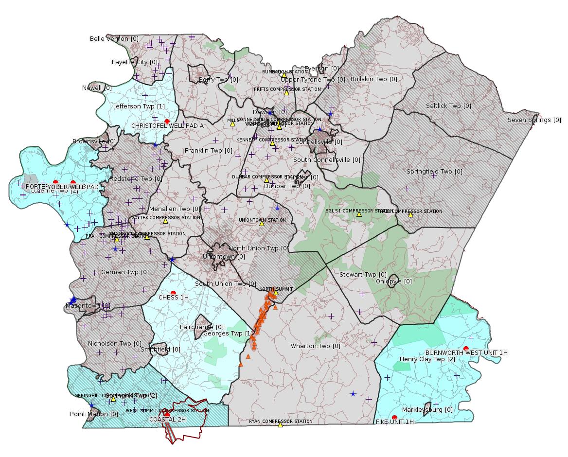
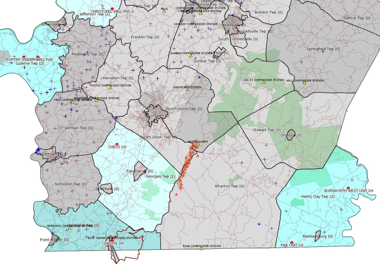
Map
Key
Red dots: items in this permit list with an exact location.
Blue stars: Marcellus Gas Well Water Sources.
Where well laterals are mapped they show in red; a 400-foot buffer surrounding the lateral shows in blue (lavender where it overlaps a mapped mineral tract).
Where mineral tracts are mapped, they show in pink. Mineral tracts can overlap; the overlap will show in red. The precise meaning of "mineral tract" is not clear.
Municipality shading: number of "facilities", with each well counting separately
(includes the red dots):
gray: 0
pale turquoise: 1
turquoise: 2
pale blue: 3
middle blue: 4
dark blue: 5
dark purple: 6
purple: 18
(Color coding may differ from one issue to the next.)
(Note if a project spans multiple municipalities -- e.g. a pipeline -- it will show in the count for each municipality.)
The number of facilities also follows the municipality name in brackets.
Municipality counts are based on the way the permit is listed by DEP; DEP has been known to get a municipality wrong.
Locations in brackets identify a precise location used to locate a surrogate for the actual site being permitted (e.g. locating a well pad or pipeline by the known location of a well.) Locations labeled beginning with "~" and ending in "[?]" are approximate and speculative based on inferences using on-line property and lease records. These are marked in the text as "[Approximate, Speculative]
Cross-hatching: Environmental Justice Areas
Yellow triangles: Compressor Stations
Orange triangles: Storage Field Wells (currently Dominion North Summit Storage Field)
Crosses: SPUD Unconventional well permits
Green: "Natural areas", e.g. state game lands, state forests
Yellow triangles: Compressor Stations
Orange triangles: Storage Field Wells (currently Dominion North Summit Storage Field)
Crosses: SPUD Unconventional well permits
Green: "Natural areas", e.g. state game lands, state forests
More Maps
 |
Source: Pennsylvania Bulletin
DEP ID: 012-0501-002. Title: Environmental Justice Public Participation Policy. Description: The Department conducted a process of revising the Environmental Justice (EJ) Public Participation Policy (Policy) that was released for public comment in 2018. The Policy focused on enhancing public participation during permit reviews for specific trigger permits that warranted additional public input and engagement in specific geographic areas, that is, EJ areas. The draft Policy included several revisions and updates but continued to focus solely on public engagement in the permitting process.
Comments received during the public comment period suggested that the Policy extend beyond enhancing outreach during the permit review process. After reviewing all comments received, the Department has decided to withdraw the Policy to develop a Policy that will focus on integrating EJ into other Department practices and policies to provide tangible benefits to communities. The Department is focused on incorporating a community engagement process to ensure inclusive community voice around its creation. The Policy is proposed to include: revised EJ areas/population definition; interagency collaboration and EJ planning; EJ mapping, resource and data development; grantmaking practices around EJ; translation processes; and EJ training for Department staff and external partners.
Contact: Questions regarding this TGD can be directed to Allison Acevedo at alacevedo@pa.gov or (484) 250-5818.
Effective Date: November 2, 2020
PATRICK McDONNELL,
Secretary
<http://www.pacodeandbulletin.gov/Display/pabull?file=/secure/pabulletin/data/vol50/50-43/1458.html>
---
NOTICES
DEPARTMENT OF
ENVIRONMENTAL PROTECTION
Proposed Conditional State Water Quality Certification under Section 401 of the Clean Water Act for the United States Army Corps of Engineers Nationwide Permits
[50 Pa.B. 6062]
[Saturday, October 31, 2020]
The United States Army Corps of Engineers (Corps) has published its proposal to reissue and modify Nationwide permits (NWP), including the issuance of five new NWPs under section 404 of the Clean Water Act (act) (33 U.S.C.A. § 1344) and section 10 of the Rivers and Harbors Act of 1899 (33 U.S.C.A. § 403) at 85 FR 57298 (September 15, 2020). The NWPs are listed as follows and would be effective for 5 years upon final issuance in the Federal Register. On October 15, 2020, the Corps Baltimore District requested State Water Quality Certification (SWQC) on behalf of the Baltimore, Philadelphia and Pittsburgh Districts under section 401 of the act (33 U.S.C.A § 1341) from the Department of Environmental Protection (Department) for discharges of dredged and fill material into waters of this Commonwealth authorized by the final NWPs.
Consistent with section 401 of the act, the Department proposes to certify that activities authorized by the Corps under the final NWPs will comply with the applicable provisions of sections 301—303, 306 and 307 of the act (33 U.S.C.A. §§ 1311—1313, 1316 and 1317), provided the project applicant complies with the following SWQC conditions and constructs, operates and maintains the project in compliance with the terms and conditions of State law permits obtained to meet these SWQC conditions:
1. Prior to beginning any activity authorized by the Corps under a NWP, the applicant shall obtain from the Department all necessary environmental permits or approvals, and submit to the Department environmental assessments and other information necessary to obtain the permits and approvals, as required under State law, including The Clean Streams Law (35 P.S. §§ 691.1—691.1001), the Dam Safety and Encroachments Act (32 P.S. §§ 693.1—693.27), the Surface Mining Conservation and Reclamation Act (52 P.S. §§ 1396.1—1396.19b), the Noncoal Surface Mining Conservation and Reclamation Act (52 P.S. §§ 3301—3326), The Bituminous Mine Subsidence and Land Conservation Act (52 P.S. §§ 1406.1—1406.21), the Coal Refuse Disposal Control Act (52 P.S. §§ 30.51—30.66), the Solid Waste Management Act (35 P.S. §§ 6018.101—6018.1003), the Hazardous Sites Cleanup Act (35 P.S. §§ 6020.101—6020.1305), the Land Recycling and Environmental Remediation Standards Act (35 P.S. §§ 6026.101—6026.908), 58 Pa.C.S. §§ 3201—3274 (relating to development), the Air Pollution Control Act (35 P.S. §§ 4001—4015) and the regulations promulgated thereunder, including 25 Pa. Code Chapters 77, 78, 78a, 86—91, 92a, 93, 95, 96, 102, 105, 127 and 260a—299.
2. Fill material may not contain any waste as defined in the Solid Waste Management Act.
3. Applicants and projects eligible for these NWPs must obtain all State permits or approvals, or both, necessary to ensure that the project meets the state's applicable water quality standards, including a project specific SWQC.
The Department has determined that these proposed SWQC conditions are necessary to achieve the Commonwealth's water quality standards, which have been approved by the United States Environmental Protection Agency as compliant with the act. The proposed SWQC conditions achieve these standards through compliance with existing environmental programs administered by the Department under State laws and regulations.
This proposed SWQC would be subject to the Department's determination that the final NWPs are consistent with the Coastal Zone Management Act (16 U.S.C.A. §§ 1451—1466).
This proposed SWQC would only be available for projects that do not require any Federal authorization other than authorization from the Corps under section 404 of the act or section 10 of the Rivers and Harbors Act of 1899. Applicants seeking authorization for activities not eligible for coverage under the NWPs, or for activities that require another Federal authorization (such as an interstate natural gas pipeline, a gas storage field or a nuclear or hydroelectric project requiring authorization by another Federal agency), must submit a request to the Department for a project-specific SWQC.
The Department will consider all comments received on or before November 30, 2020, before taking the final action on this proposed conditional SWQC. Comments submitted by facsimile will not be accepted. Comments, including comments submitted by e-mail, must include the commentator's name and address. Commentators are encouraged to submit comments using the Department's online eComment tool at www.ahs.dep.pa.gov/eComment or ecomment@pa.gov. Written comments can be mailed to the Department of Environmental Protection, Policy Office, 400 Market Street, P.O. Box 2063, Harrisburg, PA 17101-2063. Use ''Proposed SWQC'' as the subject line in written communication.
Comments on regional issues relating to the proposed NWPs and proposed regional conditions should be sent to the United States Army Corps of Engineers, Baltimore District, State College Field Office, 1631 South Atherton Street, Suite 101, State College, PA 16801, Attn: Amy Elliott or amy.h.elliott@usace.army.mil. Comments relating to regional conditions are due to the Corps State College Field Office by 45 days from September 30, 2020.
A full text copy of the NWPs is available on the Corps web site at www.usace.army.mil/Missions/Civil-Works/Regulatory-Program-and-Permits/Nationwide-Permits, on the Federal Register web site at www.federalregister.gov/documents/2020/09/15/2020-17116/proposal-to-reissue-and-modify-nationwide-permits, or online at www.regulations.gov—search by Docket COE-2020-0002.
The list of all NWPs proposed for modification or reissuance are as follows:
1. Aids to Navigation
2. Structures in Artificial Canals
3. Maintenance
4. Fish and Wildlife Harvesting, Enhancement, and Attraction Devices and Activities
5. Scientific Measurement Devices
6. Survey Activities
7. Outfall Structures and Associated Intake Structures
8. Oil and Gas Structures on the Outer Continental Shelf
9. Structures in Fleeting and Anchorage Areas
10. Mooring Buoys
11. Temporary Recreational Structures
12. Oil or Natural Gas Pipeline Activities
13. Bank Stabilization
14. Linear Transportation Projects
15. United States Coast Guard Approved Bridges
16. Return Water from Upland Contained Disposal Areas
17. Hydropower Projects
18. Minor Discharges
19. Minor Dredging
20. Response Operations for Oil or Hazardous Substances
21. Surface Coal Mining Activities
22. Removal of Vessels
23. Approved Categorical Exclusions
24. Indian Tribe or State Administered Section 404 Programs
25. Structural Discharges
26. (Reserved)
27. Aquatic Habitat Restoration, Establishment and Enhancement Activities
28. Modifications of Existing Marinas
29. Residential Developments
30. Moist Soil Management for Wildlife
31. Maintenance of Existing Flood Control Facilities
32. Completed Enforcement Actions
33. Temporary Construction, Access and Dewatering
34. Cranberry Production Activities
35. Maintenance Dredging of Existing Basins
36. Boat Ramps
37. Emergency Watershed Protection and Rehabilitation
38. Cleanup of Hazardous and Toxic Waste
39. Commercial and Institutional Developments
40. Agricultural Activities
41. Reshaping Existing Drainage Ditches
42. Recreational Facilities
43. Stormwater Management Facilities
44. Mining Activities
45. Repair of Uplands Damaged by Discrete Events
46. Discharges in Ditches
47. (Reserved)
48. Commercial Shellfish Mariculture Activities
49. Coal Remining Activities
50. Underground Coal Mining Activities
51. Land-Based Renewable Energy Generation Facilities
52. Water-Based Renewable Energy Generation Pilot Projects
53. Removal of Low-Head Dams
54. Living Shorelines
A. Seaweed Mariculture Activities
B. Finfish Mariculture Activities
C. Electric Utility Line and Telecommunications Activities
D. Utility Line Activities for Water and Other Substances
E. Water Reclamation and Reuse Facilities
The proposed NWP suspensions (Enclosure 1) and regional conditions (Enclosure 3) applicable to the Com-monwealth were released by Special Public Notice (SPN-20-60) and are available on the Corps web site by searching for ''SPN-20-60'' or at www.nab.usace.army.mil/Missions/Regulatory/Public-Notices/Public-Notice-View/Article/2364484/spn-20-62-nationwide-permit-reissueance-request-for-comments.
PATRICK McDONNELL,
Secretary
<http://www.pacodeandbulletin.gov/Display/pabull?file=/secure/pabulletin/data/vol50/50-44/1496.html>
See Also:
<https://www.lrp.usace.army.mil/Portals/72/SPN-20-62-20200930.pdf>
www.regulations.gov Docket coe-2020-0002
<https://beta.regulations.gov/search?filter=coe-2020-0002>
-------------------------
Source: eNOTICE
(+ PA
Oil and Gas Mapping, Well
Pad Report.) Well Details via Data
Portal Services: Oil and Gas Wells All (ID: 3).
Please see the Disclaimer below regarding Parcel Id data.
Authorization ID: 1332011
Permit number: ESG072619003-00
Site: PORTER WELL PAD B ESCGP ESG072619003-00
Client: CHEVRON APPALACHIA LLC
Authorization type: Erosion and Sediment Control GP-2
Application type: Notification
Authorization is for: SITE
Date received: 10/23/2020
Status: Pending
Permit Decision Guarantee Applies?: No
Permit Review Notes:
Date Review Note
10/29/2020 The permit application package is complete, has been accepted, and is undergoing technical review.
<https://www.ahs.dep.pa.gov/eFACTSWeb/searchResults_singleAuth.aspx?AuthID=1332011>
Site Programs:
Site Municipalities:
Luzerne Twp, Fayette County
---
Authorization ID: 1332006
Permit number: ESG072618001-00
Site: CHRISTOFEL WELL PAD A PROJECT ESG30705118-001
Client: CHEVRON APPALACHIA LLC
Authorization type: Erosion and Sediment Control GP-2
Application type: Notification
Authorization is for: SITE
Date received: 10/23/2020
Status: Pending
Permit Decision Guarantee Applies?: No
Permit Review Notes:
Date Review Note
10/29/2020 The permit application package is complete, has been accepted, and is undergoing technical review.
<https://www.ahs.dep.pa.gov/eFACTSWeb/searchResults_singleAuth.aspx?AuthID=1332006>
Site Programs:
Oil & Gas
Site Municipalities:
Jefferson Twp, Fayette County
---
Authorization ID: 1328735
Permit number: ESX15-051-0007
Site: YODER WELL PAD ESCGP-2 EXPEDITED
Client: CHEVRON APPALACHIA LLC
Authorization type: Expedited E&S Stormwater General Permit 1
Application type: Notification
Authorization is for: SITE
Date received: 09/30/2020
Status: Pending
Permit Decision Guarantee Applies?: No
Permit Review Notes:
Date Review Note
10/29/2020 The technical review and decision review are complete and either the permit decision and/or permit issuance are forthcoming.
9/30/2020 The permit application package is complete, has been accepted, and is undergoing technical review.
<https://www.ahs.dep.pa.gov/eFACTSWeb/searchResults_singleAuth.aspx?AuthID=1328735>
Site Programs:
Oil & Gas
Site Municipalities:
Luzerne Twp, Fayette County
Authorization ID: 1325874
Permit number: 051-24719
Site: CHESS 1H ESCGP-EXPEDITED
Client: INR OPR LLC
Authorization type: Drill & Operate Well Permit (Conventional)
Application type: Renewal
Authorization is for: FACILITY
Date received: 09/02/2020
Status: Issued on 10/22/2020
Permit Decision Guarantee Applies?: Yes
Permit Decision Guarantee status: ACTIVE
Permit Review Notes:
Date Review Note
9/8/2020 The technical review and decision review are complete and either the permit decision and/or permit issuance are forthcoming.
9/3/2020 The permit application package is complete, has been accepted, and is undergoing technical review.
<https://www.ahs.dep.pa.gov/eFACTSWeb/searchResults_singleAuth.aspx?AuthID=1325874>
Site Programs:
Oil & Gas
Site Municipalities:
Georges Twp, Fayette County
Well Details:
Permit Number: 051-24719
Well Name: CHESS 1H
Unconventional Well: N
Well Configuration: Vertical Well
Well Type: GAS
Well Status: Proposed But Never Materialized
Coal Association: Coal
Conservation Well: Y
Primary Facility ID: 836896
Site ID: 735899
Site Name: CHESS 1H ESCGP-EXPEDITED
Well Pad ID: 0
Well Pad Name:
Storage Field:
Operator: INR OPR LLC
Operator Number: OGO-51036
Permit Date: 2019-09-24
Permit Date Expires: 2021-09-24
SPUD Date:
Date Plugged:
UIC ID:
UIC Type:
Surface Elevation: 1183
County: Fayette
Municipality: Georges Twp
Location: 39.859844,-79.7907
Map URL: <http://www.openstreetmap.org/?mlat=39.859844&mlon=-79.7907#map=15/39.859844/-79.7907>
OG WELLS PERMIT DOCS:
2020-02-13: Initial Submitted Documents, Name: 1284748 (for Authorization: 1284748):
<http://www.depgis.state.pa.us/pdfHandler/pdFHandler.ashx?Doc=OTI2ODky&ext=PDF>
2020-02-13: Final Permit Documents, Name: 051-24719 (for Authorization: 1284748):
<http://www.depgis.state.pa.us/pdfHandler/pdFHandler.ashx?Doc=OTQxNjUx&ext=PDF>
2020-10-22: Final Permit Documents, Name: 051_24719_Chess 1H_1325874_signed (for Authorization: 1325874):
<http://www.depgis.state.pa.us/pdfHandler/pdFHandler.ashx?Doc=MTQyMzc0Mw==&ext=PDF>
2020-10-22: Initial Submitted Documents, Name: 051-24719 (for Authorization: 1325874):
<http://www.depgis.state.pa.us/pdfHandler/pdFHandler.ashx?Doc=MTQxNTk2Mg==&ext=PDF>
2020-10-22: Final Permit Documents, Name: Auth 1325874 051-24719 (for Authorization: 1325874):
<http://www.depgis.state.pa.us/pdfHandler/pdFHandler.ashx?Doc=MTUxNjUyMA==&ext=PDF>
-------------------------
Source: DEP
Oil and Gas Electronic Notifications
NOTIFICATION_ID: 54389
OGO: 51036
OPERATOR: INR OPR LLC
API_PERMIT: 051-24722
SPUD_DATE: 09/29/2020
COUNTY: Fayette
MUNICIPALITY: Springhill
LATITUDE: 39.73315
LONGITUDE: -79.800903
SUBJECT: [NOTIFICATION]: Casing cementing notification 58 Pa. C.S. 3211(f)(2) for well API 37-051-24722-00-00
QUESTION: Enter the Date and Time for the applicable Casing Types
ANSWER: Surface: 10/25/2020 11:00:00 AM
SENT_DATE: 10/23/2020 10:40:25 AM
SENT_SUCCESS: Yes
LAST_RESENT_DATE:
RESENT_SUCCESS:
REGION: EP DOGO SWDO Dstr Off
Well Details:
Permit Number: 051-24722
Well Name: COASTAL 2H
Unconventional Well: Y
Well Configuration: Horizontal Well
Well Type: GAS
Well Status: Active
Coal Association: Coal
Conservation Well: N
Primary Facility ID: 843825
Site ID: 739525
Site Name: COASTAL 1H FLOW BACK PIT FRESHWATER PITS ESCGP-EXPEDITED
Well Pad ID: 147971
Well Pad Name: COASTAL WELL PAD
Storage Field:
Operator: INR OPR LLC
Operator Number: OGO-51036
Permit Date: 2020-09-22
Permit Date Expires: 2021-09-22
SPUD Date: 2020-09-29
Date Plugged:
UIC ID:
UIC Type:
Surface Elevation: 1127
County: Fayette
Municipality: Springhill Twp
Location: 39.73315,-79.800903
Map URL: <http://www.openstreetmap.org/?mlat=39.73315&mlon=-79.800903#map=15/39.73315/-79.800903>
OG WELLS PERMIT DOCS:
2020-09-22: Final Permit Documents, Name: Auth 1322984 051-24722 (for Authorization: 1322984):
<http://www.depgis.state.pa.us/pdfHandler/pdFHandler.ashx?Doc=MTQ1NTA4Mg==&ext=PDF>
2020-09-22: Other Permit Documents, Name: Coastal Wells Deficiency Email (for Authorization: 1322984):
<http://www.depgis.state.pa.us/pdfHandler/pdFHandler.ashx?Doc=MTQwNzgyOQ==&ext=PDF>
Electronically Submitted Records:
2020-09-22: Submission for Authorization 1322984
Interested Party Notification: Coastal 2H - Springhill Township - Interested Party Signed Receipt - 08.04.2020.pdf
<http://www.depgis.state.pa.us/eWellDocHandler/pdFHandler.ashx?Doc=MTI1MjgxNw==&ext=PDF>
Coordination of Well Location with Public Resources: INR OPERATING - COASTAL 2H - COORDINATION_OF_WELL_LOCATION_WITH_PUBLIC_RESOURCES.pdf
<http://www.depgis.state.pa.us/eWellDocHandler/pdFHandler.ashx?Doc=MTI2MTg1Mg==&ext=PDF>
Pennsylvania Natural Diversity Inventory Form: INR OPERATING - COASTAL 2H - PNDI INVENTORY 07.21.2020.pdf
<http://www.depgis.state.pa.us/eWellDocHandler/pdFHandler.ashx?Doc=MTI2MTg1Mw==&ext=PDF>
Pennsylvania Natural Diversity Inventory Support Document: INR OPERATING - COASTAL 2H - PNDI SUPPORT 07.21.2020.pdf
<http://www.depgis.state.pa.us/eWellDocHandler/pdFHandler.ashx?Doc=MTI2MTg1NQ==&ext=PDF>
Operator Ownership and Control Information: INR OPERATING - COASTAL 2H - OPERATOR_OWNERSHIP_AND_CONTROL_INFORMATION_FORM 07.21.2020.pdf
<http://www.depgis.state.pa.us/eWellDocHandler/pdFHandler.ashx?Doc=MTI2MTg1Ng==&ext=PDF>
Well Permit Application - Coal Module: INR OPERATING - COASTAL 2H - COAL STATUS REPORT 07.24.2020.pdf
<http://www.depgis.state.pa.us/eWellDocHandler/pdFHandler.ashx?Doc=MTI2MTg1OA==&ext=PDF>
Location Plat: INR OPERATING - COASTAL 2H - LOCATION PLAT 08.25.2020 DEP COMMENT REVISIONS.dwg
<http://www.depgis.state.pa.us/eWellDocHandler/pdFHandler.ashx?Doc=MTI2ODM2Nw==&ext=PDF>
Well Cross-Section Diagram: INR OPERATING - COASTAL 2H - WELL CROSS-SECTION DIAGRAM 08.25.2020 DEP COMMENT REVISIONS.pdf
<http://www.depgis.state.pa.us/eWellDocHandler/pdFHandler.ashx?Doc=MTI2ODM3Mw==&ext=PDF>
Location Plat: INR OPERATING - COASTAL 2H - LOCATION PLAT 08.25.2020 DEP COMMENT REVISIONS.dwg
<http://www.depgis.state.pa.us/eWellDocHandler/pdFHandler.ashx?Doc=MTI2ODM3OA==&ext=PDF>
Permit Application to Drill and Operate a Well: 1958801.pdf
<http://www.depgis.state.pa.us/eWellDocHandler/pdFHandler.ashx?Doc=MTI2ODM4MA==&ext=PDF>
---
NOTIFICATION_ID: 54390
OGO: 51036
OPERATOR: INR OPR LLC
API_PERMIT: 051-24721
SPUD_DATE: 09/29/2020
COUNTY: Fayette
MUNICIPALITY: Springhill
LATITUDE: 39.733181
LONGITUDE: -79.800869
SUBJECT: [NOTIFICATION]: Casing cementing notification 58 Pa. C.S. 3211(f)(2) for well API 37-051-24721-00-00
QUESTION: Enter the Date and Time for the applicable Casing Types
ANSWER: Surface: 10/27/2020 6:00:00 AM
SENT_DATE: 10/23/2020 10:41:23 AM
SENT_SUCCESS: Yes
LAST_RESENT_DATE:
RESENT_SUCCESS:
REGION: EP DOGO SWDO Dstr Off
Well Details:
Permit Number: 051-24721
Well Name: COASTAL 4H
Unconventional Well: Y
Well Configuration: Horizontal Well
Well Type: GAS
Well Status: Active
Coal Association: Coal
Conservation Well: N
Primary Facility ID: 843824
Site ID: 739525
Site Name: COASTAL 1H FLOW BACK PIT FRESHWATER PITS ESCGP-EXPEDITED
Well Pad ID: 147971
Well Pad Name: COASTAL WELL PAD
Storage Field:
Operator: INR OPR LLC
Operator Number: OGO-51036
Permit Date: 2020-09-22
Permit Date Expires: 2021-09-22
SPUD Date: 2020-09-29
Date Plugged:
UIC ID:
UIC Type:
Surface Elevation: 1127
County: Fayette
Municipality: Springhill Twp
Location: 39.733181,-79.800869
Map URL: <http://www.openstreetmap.org/?mlat=39.733181&mlon=-79.800869#map=15/39.733181/-79.800869>
OG WELLS PERMIT DOCS:
2020-09-22: Final Permit Documents, Name: Auth 1322978 051-24721 (for Authorization: 1322978):
<http://www.depgis.state.pa.us/pdfHandler/pdFHandler.ashx?Doc=MTQ1NTA3OQ==&ext=PDF>
2020-09-22: Other Permit Documents, Name: Coastal Wells Deficiency Email (for Authorization: 1322978):
<http://www.depgis.state.pa.us/pdfHandler/pdFHandler.ashx?Doc=MTQwNzk4MQ==&ext=PDF>
Electronically Submitted Records:
2020-09-22: Submission for Authorization 1322978
Pennsylvania Natural Diversity Inventory Form: INR OPERATING - COASTAL 4H - PNDI INVENTORY 07.21.2020.pdf
<http://www.depgis.state.pa.us/eWellDocHandler/pdFHandler.ashx?Doc=MTIzMzcxOQ==&ext=PDF>
Pennsylvania Natural Diversity Inventory Support Document: INR OPERATING - COASTAL 4H - PNDI SUPPORT 07.21.2020.pdf
<http://www.depgis.state.pa.us/eWellDocHandler/pdFHandler.ashx?Doc=MTIzMzcyMQ==&ext=PDF>
Operator Ownership and Control Information: INR OPERATING - COASTAL 4H - OPERATOR_OWNERSHIP_AND_CONTROL_INFORMATION_FORM 07.21.2020.pdf
<http://www.depgis.state.pa.us/eWellDocHandler/pdFHandler.ashx?Doc=MTIzMzcyMg==&ext=PDF>
Coordination of Well Location with Public Resources: INR OPERATING - COASTAL 4H - COORDINATION_OF_WELL_LOCATION_WITH_PUBLIC_RESOURCES.pdf
<http://www.depgis.state.pa.us/eWellDocHandler/pdFHandler.ashx?Doc=MTIzNjcxMQ==&ext=PDF>
Well Permit Application - Coal Module: INR OPERATING - COASTAL 4H - COAL STATUS REPORT 07.24.2020.pdf
<http://www.depgis.state.pa.us/eWellDocHandler/pdFHandler.ashx?Doc=MTIzOTY5MA==&ext=PDF>
Interested Party Notification: Coastal 4H - Springhill Township - Interested Party Signed Receipt - 08.04.2020.pdf
<http://www.depgis.state.pa.us/eWellDocHandler/pdFHandler.ashx?Doc=MTI1MjgyNA==&ext=PDF>
Location Plat: INR OPERATING - COASTAL 4H - LOCATION PLAT 08.25.2020 DEP COMMENT REVISIONS.dwg
<http://www.depgis.state.pa.us/eWellDocHandler/pdFHandler.ashx?Doc=MTI2ODY2Mw==&ext=PDF>
Well Cross-Section Diagram: INR OPERATING - COASTAL 4H - WELL CROSS-SECTION DIAGRAM 08.25.2020 DEP COMMENT REVISIONS.pdf
<http://www.depgis.state.pa.us/eWellDocHandler/pdFHandler.ashx?Doc=MTI2ODY2NA==&ext=PDF>
Location Plat: INR OPERATING - COASTAL 4H - LOCATION PLAT 08.25.2020 DEP COMMENT REVISIONS.dwg
<http://www.depgis.state.pa.us/eWellDocHandler/pdFHandler.ashx?Doc=MTI2ODY2NQ==&ext=PDF>
Permit Application to Drill and Operate a Well: 2141432.pdf
<http://www.depgis.state.pa.us/eWellDocHandler/pdFHandler.ashx?Doc=MTI2ODY3MA==&ext=PDF>
---
NOTIFICATION_ID: 54393
OGO: 51036
OPERATOR: INR OPR LLC
API_PERMIT: 051-24722
SPUD_DATE: 09/29/2020
COUNTY: Fayette
MUNICIPALITY: Springhill
LATITUDE: 39.73315
LONGITUDE: -79.800903
SUBJECT: [NOTIFICATION]: Disposal of drill cuttings (unconventional wells) 78a.61(e) for well API 37-051-24722-00-00
QUESTION: Proposed date/time
ANSWER: Date: 10/28/2020 Time: 01:00 PM
SENT_DATE: 10/23/2020 12:52:35 PM
SENT_SUCCESS: Yes
LAST_RESENT_DATE:
RESENT_SUCCESS:
REGION: EP DOGO SWDO Dstr Off
Well Details above
Well Name: COASTAL 2H
---
NOTIFICATION_ID: 54394
OGO: 51036
OPERATOR: INR OPR LLC
API_PERMIT: 051-24721
SPUD_DATE: 09/29/2020
COUNTY: Fayette
MUNICIPALITY: Springhill
LATITUDE: 39.733181
LONGITUDE: -79.800869
SUBJECT: [NOTIFICATION]: Disposal of drill cuttings (unconventional wells) 78a.61(e) for well API 37-051-24721-00-00
QUESTION: Proposed date/time
ANSWER: Date: 10/28/2020 Time: 01:00 PM
SENT_DATE: 10/23/2020 12:53:05 PM
SENT_SUCCESS: Yes
LAST_RESENT_DATE:
RESENT_SUCCESS:
REGION: EP DOGO SWDO Dstr Off
Well Details above
Well Name: COASTAL 4H
---
NOTIFICATION_ID: 54434
OGO: 51036
OPERATOR: INR OPR LLC
API_PERMIT: 051-24722
SPUD_DATE: 09/29/2020
COUNTY: Fayette
MUNICIPALITY: Springhill
LATITUDE: 39.73315
LONGITUDE: -79.800903
SUBJECT: [NOTIFICATION]: Casing cementing notification 58 Pa. C.S. 3211(f)(2) for well API 37-051-24722-00-00
QUESTION: Enter the Date and Time for the applicable Casing Types
ANSWER: Intermediate: 10/29/2020 9:00:00 PM
SENT_DATE: 10/28/2020 7:45:01 AM
SENT_SUCCESS: Yes
LAST_RESENT_DATE:
RESENT_SUCCESS:
REGION: EP DOGO SWDO Dstr Off
Well Details above
Well Name: COASTAL 2H
---
NOTIFICATION_ID: 54475
OGO: 51036
OPERATOR: INR OPR LLC
API_PERMIT: 051-24721
SPUD_DATE: 09/29/2020
COUNTY: Fayette
MUNICIPALITY: Springhill
LATITUDE: 39.733181
LONGITUDE: -79.800869
SUBJECT: [NOTIFICATION]: Casing cementing notification 58 Pa. C.S. 3211(f)(2) for well API 37-051-24721-00-00
QUESTION: Enter the Date and Time for the applicable Casing Types
ANSWER: Intermediate: 11/2/2020 7:00:00 PM
SENT_DATE: 11/1/2020 9:05:07 AM
SENT_SUCCESS: Yes
LAST_RESENT_DATE:
RESENT_SUCCESS:
REGION: EP DOGO SWDO Dstr Off
Well Details above
Well Name: COASTAL 4H
OPERATOR: LPR ENERGY LLC
INSPECTION_ID: 3092592
INSPECTION_DATE: 10/14/2020
INSPECTION_TYPE: Compliance Evaluation
API_PERMIT: 051-24164
FARM_NAME: FIKE UNIT 1H
UNCONVENTIONAL: Yes
SITE_ID: 716179
SITE_NAME: FIKE UNIT 1H OG WELL
FACILITY_TYPE: Oil & Gas Location
INSPECTION_CATEGORY: Primary Facility
REGION: EP DOGO SWDO Dstr Off
COUNTY: Fayette
MUNICIPALITY: Henry Clay Twp
INSPECTOR: WOODS, MATTHEW
INSPECTION_SOURCE: SUBSAIR
INSPECTION_RESULT_DESCRIPTION: No Violations Noted
INSPECTION_COMMENT: "According to Department records this well is in regulatory inactive status. Well does not appear equipped for production. Well pad surrounded by security fence. Well head surrounded by security fence.
A follow up inspection will be conducted at a later date to ensure site ID sign is properly installed."
Well Details:
Permit Number: 051-24164
Well Name: FIKE UNIT 1H
Unconventional Well: Y
Well Configuration: Horizontal Well
Well Type: GAS
Well Status: Regulatory Inactive Status
Coal Association: NonCoal
Conservation Well: Y
Primary Facility ID: 715064
Site ID: 716179
Site Name: FIKE UNIT 1H OG WELL
Well Pad ID: 146852
Well Pad Name: FIKE UNIT 1H
Storage Field:
Operator: LPR ENERGY LLC
Operator Number: OGO-68579
Permit Date: 2009-02-09
Permit Date Expires: 2010-02-09
SPUD Date: 2009-02-12
Date Plugged:
UIC ID:
UIC Type:
Surface Elevation: 2222
County: Fayette
Municipality: Henry Clay Twp
Location: 39.727028,-79.495752
Map URL: <http://www.openstreetmap.org/?mlat=39.727028&mlon=-79.495752#map=15/39.727028/-79.495752>
OG WELLS PERMIT DOCS:
2016-06-13: Other Permit Documents, Name: PAG104834_3-1-2016_TENNESSEE GAS PIPELINE (for Authorization: 758213):
<http://www.depgis.state.pa.us/pdfHandler/pdFHandler.ashx?Doc=ODY1OTgw&ext=PDF>
2016-06-13: Other Permit Documents, Name: PAG104834_3-1-2017_TENNESEE GAS PIPELINE (for Authorization: 758213):
<http://www.depgis.state.pa.us/pdfHandler/pdFHandler.ashx?Doc=ODY1OTgx&ext=PDF>
2018-04-23: Other Permit Documents, Name: 1149059 (for Authorization: 1149059):
<http://www.depgis.state.pa.us/pdfHandler/pdFHandler.ashx?Doc=NTk4NzYw&ext=PDF>
2019-09-30: Other Permit Documents, Name: Inactive Well Status (for Authorization: 1290096):
<http://www.depgis.state.pa.us/pdfHandler/pdFHandler.ashx?Doc=OTM1NzQ3&ext=PDF>
---
OPERATOR: LPR ENERGY LLC
INSPECTION_ID: 3092523
INSPECTION_DATE: 10/14/2020
INSPECTION_TYPE: Compliance Evaluation
API_PERMIT: 051-24325
FARM_NAME: BURNWORTH UNIT 1H
UNCONVENTIONAL: Yes
SITE_ID: 730706
SITE_NAME: BURNWORTH UNIT 1H OG WELL
FACILITY_TYPE: Oil & Gas Location
INSPECTION_CATEGORY: Primary Facility
REGION: EP DOGO SWDO Dstr Off
COUNTY: Fayette
MUNICIPALITY: Henry Clay Twp
INSPECTOR: WOODS, MATTHEW
INSPECTION_SOURCE: SUBSAIR
INSPECTION_RESULT_DESCRIPTION: Violation(s) Noted
INSPECTION_COMMENT: "This well is tagged and presently under regulatory inactive status.
The well head casing looks ok.
An additional compliance inspection will be conducted at a later date."
VIOLATION_ID: 898175
VIOLATION_DATE: 10/14/2020
VIOLATION_CODE: OGA3211(H) - WELL PERMITS - LABELING - Failure to install, in a permanent manner, the permit number on a completed well.
VIOLATION_TYPE: Administrative
VIOLATION_COMMENT:
RESOLVED_DATE:
RESOLUTION_REASON_CODE_DESCRIPTION:
CONTINUING_VIOLATION:
ENFORCEMENT_ID:
ENFORCEMENT_CODE_DESCRIPTION:
DATE_EXECUTED:
ENFORCEMENT_FINAL_DATE:
ENFORCEMENT_FINAL_STATUS:
PENALTY_FINAL_DATE:
PENALTY_FINAL_STATUS_CODE_DESCRIPTION:
PENALTY_AMOUNT:
TOTAL_AMOUNT_COLLECTED:
Well Details:
Permit Number: 051-24325
Well Name: BURNWORTH UNIT 1H
Unconventional Well: Y
Well Configuration: Horizontal Well
Well Type: GAS
Well Status: Regulatory Inactive Status
Coal Association: NonCoal
Conservation Well: N
Primary Facility ID: 727542
Site ID: 730706
Site Name: BURNWORTH UNIT 1H OG WELL
Well Pad ID: 146187
Well Pad Name: BURNWORTH UNIT 1H
Storage Field:
Operator: LPR ENERGY LLC
Operator Number: OGO-68579
Permit Date: 2010-03-05
Permit Date Expires: 2011-03-05
SPUD Date: 2010-05-10
Date Plugged:
UIC ID:
UIC Type:
Surface Elevation: 1890
County: Fayette
Municipality: Henry Clay Twp
Location: 39.808139,-79.390917
Map URL: <http://www.openstreetmap.org/?mlat=39.808139&mlon=-79.390917#map=15/39.808139/-79.390917>
OG WELLS PERMIT DOCS:
2018-09-27: Other Permit Documents, Name: 1237070 (for Authorization: 1237070):
<http://www.depgis.state.pa.us/pdfHandler/pdFHandler.ashx?Doc=NjkwOTgz&ext=PDF>
2019-12-17: Other Permit Documents, Name: Inactive Well Status (for Authorization: 1298517):
<http://www.depgis.state.pa.us/pdfHandler/pdFHandler.ashx?Doc=OTk3MTk2&ext=PDF>
-------------------------
Please see the Disclaimer below regarding Parcel Id data.
Authorization ID: 1332011
Permit number: ESG072619003-00
Site: PORTER WELL PAD B ESCGP ESG072619003-00
Client: CHEVRON APPALACHIA LLC
Authorization type: Erosion and Sediment Control GP-2
Application type: Notification
Authorization is for: SITE
Date received: 10/23/2020
Status: Pending
Permit Decision Guarantee Applies?: No
Permit Review Notes:
Date Review Note
10/29/2020 The permit application package is complete, has been accepted, and is undergoing technical review.
<https://www.ahs.dep.pa.gov/eFACTSWeb/searchResults_singleAuth.aspx?AuthID=1332011>
Site Programs:
Site Municipalities:
Luzerne Twp, Fayette County
Location: 39.976089,-79.947444
Map URL: <http://www.openstreetmap.org/?mlat=39.976089&mlon=-79.947444#map=15/39.976089/-79.947444>
Presumed Parcel Id: 19160044
Act 14 Notification: <https://www.faymarwatch.org/documents/SKM_554e19100809140.pdf>
[See Notes.]
Map URL: <http://www.openstreetmap.org/?mlat=39.976089&mlon=-79.947444#map=15/39.976089/-79.947444>
Presumed Parcel Id: 19160044
Act 14 Notification: <https://www.faymarwatch.org/documents/SKM_554e19100809140.pdf>
[See Notes.]
---
Authorization ID: 1332006
Permit number: ESG072618001-00
Site: CHRISTOFEL WELL PAD A PROJECT ESG30705118-001
Client: CHEVRON APPALACHIA LLC
Authorization type: Erosion and Sediment Control GP-2
Application type: Notification
Authorization is for: SITE
Date received: 10/23/2020
Status: Pending
Permit Decision Guarantee Applies?: No
Permit Review Notes:
Date Review Note
10/29/2020 The permit application package is complete, has been accepted, and is undergoing technical review.
<https://www.ahs.dep.pa.gov/eFACTSWeb/searchResults_singleAuth.aspx?AuthID=1332006>
Site Programs:
Oil & Gas
Site Municipalities:
Jefferson Twp, Fayette County
Location: 40.0380,-79.7956 <https://osm.org/go/ZWp1A5yF--?m=>
Presumed Parcel Id: 17130025
Act 14 Notification:
<https://www.faymarwatch.org/documents/Christofel_Well_Pad_A_Act_14_NOI.pdf>
Presumed Parcel Id: 17130025
Act 14 Notification:
<https://www.faymarwatch.org/documents/Christofel_Well_Pad_A_Act_14_NOI.pdf>
---
Authorization ID: 1328735
Permit number: ESX15-051-0007
Site: YODER WELL PAD ESCGP-2 EXPEDITED
Client: CHEVRON APPALACHIA LLC
Authorization type: Expedited E&S Stormwater General Permit 1
Application type: Notification
Authorization is for: SITE
Date received: 09/30/2020
Status: Pending
Permit Decision Guarantee Applies?: No
Permit Review Notes:
Date Review Note
10/29/2020 The technical review and decision review are complete and either the permit decision and/or permit issuance are forthcoming.
9/30/2020 The permit application package is complete, has been accepted, and is undergoing technical review.
<https://www.ahs.dep.pa.gov/eFACTSWeb/searchResults_singleAuth.aspx?AuthID=1328735>
Site Programs:
Oil & Gas
Site Municipalities:
Luzerne Twp, Fayette County
Well Pad Id: 153100
Location: 39.975683, -79.923763
Wells on this Pad:
Presumed Parcel Id: 19160034
---Location: 39.975683, -79.923763
Wells on this Pad:
051-24652 YODER 1HPost Drill Restoration Report Yoder Pad A.pdf
051-24653 YODER 2H
051-24654 YODER 3H
051-24655 YODER 4H
051-24656 YODER 5H
051-24657 YODER 6H
051-24658 YODER 7H
051-24659 YODER 8H
051-24660 YODER 9H
051-24661 YODER 10H
051-24662 YODER 11H
051-24663 YODER 12H
Presumed Parcel Id: 19160034
Authorization ID: 1325874
Permit number: 051-24719
Site: CHESS 1H ESCGP-EXPEDITED
Client: INR OPR LLC
Authorization type: Drill & Operate Well Permit (Conventional)
Application type: Renewal
Authorization is for: FACILITY
Date received: 09/02/2020
Status: Issued on 10/22/2020
Permit Decision Guarantee Applies?: Yes
Permit Decision Guarantee status: ACTIVE
Permit Review Notes:
Date Review Note
9/8/2020 The technical review and decision review are complete and either the permit decision and/or permit issuance are forthcoming.
9/3/2020 The permit application package is complete, has been accepted, and is undergoing technical review.
<https://www.ahs.dep.pa.gov/eFACTSWeb/searchResults_singleAuth.aspx?AuthID=1325874>
Site Programs:
Oil & Gas
Site Municipalities:
Georges Twp, Fayette County
Well Details:
Permit Number: 051-24719
Well Name: CHESS 1H
Unconventional Well: N
Well Configuration: Vertical Well
Well Type: GAS
Well Status: Proposed But Never Materialized
Coal Association: Coal
Conservation Well: Y
Primary Facility ID: 836896
Site ID: 735899
Site Name: CHESS 1H ESCGP-EXPEDITED
Well Pad ID: 0
Well Pad Name:
Storage Field:
Operator: INR OPR LLC
Operator Number: OGO-51036
Permit Date: 2019-09-24
Permit Date Expires: 2021-09-24
SPUD Date:
Date Plugged:
UIC ID:
UIC Type:
Surface Elevation: 1183
County: Fayette
Municipality: Georges Twp
Location: 39.859844,-79.7907
Map URL: <http://www.openstreetmap.org/?mlat=39.859844&mlon=-79.7907#map=15/39.859844/-79.7907>
OG WELLS PERMIT DOCS:
2020-02-13: Initial Submitted Documents, Name: 1284748 (for Authorization: 1284748):
<http://www.depgis.state.pa.us/pdfHandler/pdFHandler.ashx?Doc=OTI2ODky&ext=PDF>
2020-02-13: Final Permit Documents, Name: 051-24719 (for Authorization: 1284748):
<http://www.depgis.state.pa.us/pdfHandler/pdFHandler.ashx?Doc=OTQxNjUx&ext=PDF>
2020-10-22: Final Permit Documents, Name: 051_24719_Chess 1H_1325874_signed (for Authorization: 1325874):
<http://www.depgis.state.pa.us/pdfHandler/pdFHandler.ashx?Doc=MTQyMzc0Mw==&ext=PDF>
2020-10-22: Initial Submitted Documents, Name: 051-24719 (for Authorization: 1325874):
<http://www.depgis.state.pa.us/pdfHandler/pdFHandler.ashx?Doc=MTQxNTk2Mg==&ext=PDF>
2020-10-22: Final Permit Documents, Name: Auth 1325874 051-24719 (for Authorization: 1325874):
<http://www.depgis.state.pa.us/pdfHandler/pdFHandler.ashx?Doc=MTUxNjUyMA==&ext=PDF>
Presumed Parcel Id: 14060098
[See Notes.]
-------------------------
NOTIFICATION_ID: 54389
OGO: 51036
OPERATOR: INR OPR LLC
API_PERMIT: 051-24722
SPUD_DATE: 09/29/2020
COUNTY: Fayette
MUNICIPALITY: Springhill
LATITUDE: 39.73315
LONGITUDE: -79.800903
SUBJECT: [NOTIFICATION]: Casing cementing notification 58 Pa. C.S. 3211(f)(2) for well API 37-051-24722-00-00
QUESTION: Enter the Date and Time for the applicable Casing Types
ANSWER: Surface: 10/25/2020 11:00:00 AM
SENT_DATE: 10/23/2020 10:40:25 AM
SENT_SUCCESS: Yes
LAST_RESENT_DATE:
RESENT_SUCCESS:
REGION: EP DOGO SWDO Dstr Off
Well Details:
Permit Number: 051-24722
Well Name: COASTAL 2H
Unconventional Well: Y
Well Configuration: Horizontal Well
Well Type: GAS
Well Status: Active
Coal Association: Coal
Conservation Well: N
Primary Facility ID: 843825
Site ID: 739525
Site Name: COASTAL 1H FLOW BACK PIT FRESHWATER PITS ESCGP-EXPEDITED
Well Pad ID: 147971
Well Pad Name: COASTAL WELL PAD
Storage Field:
Operator: INR OPR LLC
Operator Number: OGO-51036
Permit Date: 2020-09-22
Permit Date Expires: 2021-09-22
SPUD Date: 2020-09-29
Date Plugged:
UIC ID:
UIC Type:
Surface Elevation: 1127
County: Fayette
Municipality: Springhill Twp
Location: 39.73315,-79.800903
Map URL: <http://www.openstreetmap.org/?mlat=39.73315&mlon=-79.800903#map=15/39.73315/-79.800903>
OG WELLS PERMIT DOCS:
2020-09-22: Final Permit Documents, Name: Auth 1322984 051-24722 (for Authorization: 1322984):
<http://www.depgis.state.pa.us/pdfHandler/pdFHandler.ashx?Doc=MTQ1NTA4Mg==&ext=PDF>
2020-09-22: Other Permit Documents, Name: Coastal Wells Deficiency Email (for Authorization: 1322984):
<http://www.depgis.state.pa.us/pdfHandler/pdFHandler.ashx?Doc=MTQwNzgyOQ==&ext=PDF>
Electronically Submitted Records:
2020-09-22: Submission for Authorization 1322984
Interested Party Notification: Coastal 2H - Springhill Township - Interested Party Signed Receipt - 08.04.2020.pdf
<http://www.depgis.state.pa.us/eWellDocHandler/pdFHandler.ashx?Doc=MTI1MjgxNw==&ext=PDF>
Coordination of Well Location with Public Resources: INR OPERATING - COASTAL 2H - COORDINATION_OF_WELL_LOCATION_WITH_PUBLIC_RESOURCES.pdf
<http://www.depgis.state.pa.us/eWellDocHandler/pdFHandler.ashx?Doc=MTI2MTg1Mg==&ext=PDF>
Pennsylvania Natural Diversity Inventory Form: INR OPERATING - COASTAL 2H - PNDI INVENTORY 07.21.2020.pdf
<http://www.depgis.state.pa.us/eWellDocHandler/pdFHandler.ashx?Doc=MTI2MTg1Mw==&ext=PDF>
Pennsylvania Natural Diversity Inventory Support Document: INR OPERATING - COASTAL 2H - PNDI SUPPORT 07.21.2020.pdf
<http://www.depgis.state.pa.us/eWellDocHandler/pdFHandler.ashx?Doc=MTI2MTg1NQ==&ext=PDF>
Operator Ownership and Control Information: INR OPERATING - COASTAL 2H - OPERATOR_OWNERSHIP_AND_CONTROL_INFORMATION_FORM 07.21.2020.pdf
<http://www.depgis.state.pa.us/eWellDocHandler/pdFHandler.ashx?Doc=MTI2MTg1Ng==&ext=PDF>
Well Permit Application - Coal Module: INR OPERATING - COASTAL 2H - COAL STATUS REPORT 07.24.2020.pdf
<http://www.depgis.state.pa.us/eWellDocHandler/pdFHandler.ashx?Doc=MTI2MTg1OA==&ext=PDF>
Location Plat: INR OPERATING - COASTAL 2H - LOCATION PLAT 08.25.2020 DEP COMMENT REVISIONS.dwg
<http://www.depgis.state.pa.us/eWellDocHandler/pdFHandler.ashx?Doc=MTI2ODM2Nw==&ext=PDF>
Well Cross-Section Diagram: INR OPERATING - COASTAL 2H - WELL CROSS-SECTION DIAGRAM 08.25.2020 DEP COMMENT REVISIONS.pdf
<http://www.depgis.state.pa.us/eWellDocHandler/pdFHandler.ashx?Doc=MTI2ODM3Mw==&ext=PDF>
Location Plat: INR OPERATING - COASTAL 2H - LOCATION PLAT 08.25.2020 DEP COMMENT REVISIONS.dwg
<http://www.depgis.state.pa.us/eWellDocHandler/pdFHandler.ashx?Doc=MTI2ODM3OA==&ext=PDF>
Permit Application to Drill and Operate a Well: 1958801.pdf
<http://www.depgis.state.pa.us/eWellDocHandler/pdFHandler.ashx?Doc=MTI2ODM4MA==&ext=PDF>
Presumed Parcel Id: 36210048
---
NOTIFICATION_ID: 54390
OGO: 51036
OPERATOR: INR OPR LLC
API_PERMIT: 051-24721
SPUD_DATE: 09/29/2020
COUNTY: Fayette
MUNICIPALITY: Springhill
LATITUDE: 39.733181
LONGITUDE: -79.800869
SUBJECT: [NOTIFICATION]: Casing cementing notification 58 Pa. C.S. 3211(f)(2) for well API 37-051-24721-00-00
QUESTION: Enter the Date and Time for the applicable Casing Types
ANSWER: Surface: 10/27/2020 6:00:00 AM
SENT_DATE: 10/23/2020 10:41:23 AM
SENT_SUCCESS: Yes
LAST_RESENT_DATE:
RESENT_SUCCESS:
REGION: EP DOGO SWDO Dstr Off
Well Details:
Permit Number: 051-24721
Well Name: COASTAL 4H
Unconventional Well: Y
Well Configuration: Horizontal Well
Well Type: GAS
Well Status: Active
Coal Association: Coal
Conservation Well: N
Primary Facility ID: 843824
Site ID: 739525
Site Name: COASTAL 1H FLOW BACK PIT FRESHWATER PITS ESCGP-EXPEDITED
Well Pad ID: 147971
Well Pad Name: COASTAL WELL PAD
Storage Field:
Operator: INR OPR LLC
Operator Number: OGO-51036
Permit Date: 2020-09-22
Permit Date Expires: 2021-09-22
SPUD Date: 2020-09-29
Date Plugged:
UIC ID:
UIC Type:
Surface Elevation: 1127
County: Fayette
Municipality: Springhill Twp
Location: 39.733181,-79.800869
Map URL: <http://www.openstreetmap.org/?mlat=39.733181&mlon=-79.800869#map=15/39.733181/-79.800869>
OG WELLS PERMIT DOCS:
2020-09-22: Final Permit Documents, Name: Auth 1322978 051-24721 (for Authorization: 1322978):
<http://www.depgis.state.pa.us/pdfHandler/pdFHandler.ashx?Doc=MTQ1NTA3OQ==&ext=PDF>
2020-09-22: Other Permit Documents, Name: Coastal Wells Deficiency Email (for Authorization: 1322978):
<http://www.depgis.state.pa.us/pdfHandler/pdFHandler.ashx?Doc=MTQwNzk4MQ==&ext=PDF>
Electronically Submitted Records:
2020-09-22: Submission for Authorization 1322978
Pennsylvania Natural Diversity Inventory Form: INR OPERATING - COASTAL 4H - PNDI INVENTORY 07.21.2020.pdf
<http://www.depgis.state.pa.us/eWellDocHandler/pdFHandler.ashx?Doc=MTIzMzcxOQ==&ext=PDF>
Pennsylvania Natural Diversity Inventory Support Document: INR OPERATING - COASTAL 4H - PNDI SUPPORT 07.21.2020.pdf
<http://www.depgis.state.pa.us/eWellDocHandler/pdFHandler.ashx?Doc=MTIzMzcyMQ==&ext=PDF>
Operator Ownership and Control Information: INR OPERATING - COASTAL 4H - OPERATOR_OWNERSHIP_AND_CONTROL_INFORMATION_FORM 07.21.2020.pdf
<http://www.depgis.state.pa.us/eWellDocHandler/pdFHandler.ashx?Doc=MTIzMzcyMg==&ext=PDF>
Coordination of Well Location with Public Resources: INR OPERATING - COASTAL 4H - COORDINATION_OF_WELL_LOCATION_WITH_PUBLIC_RESOURCES.pdf
<http://www.depgis.state.pa.us/eWellDocHandler/pdFHandler.ashx?Doc=MTIzNjcxMQ==&ext=PDF>
Well Permit Application - Coal Module: INR OPERATING - COASTAL 4H - COAL STATUS REPORT 07.24.2020.pdf
<http://www.depgis.state.pa.us/eWellDocHandler/pdFHandler.ashx?Doc=MTIzOTY5MA==&ext=PDF>
Interested Party Notification: Coastal 4H - Springhill Township - Interested Party Signed Receipt - 08.04.2020.pdf
<http://www.depgis.state.pa.us/eWellDocHandler/pdFHandler.ashx?Doc=MTI1MjgyNA==&ext=PDF>
Location Plat: INR OPERATING - COASTAL 4H - LOCATION PLAT 08.25.2020 DEP COMMENT REVISIONS.dwg
<http://www.depgis.state.pa.us/eWellDocHandler/pdFHandler.ashx?Doc=MTI2ODY2Mw==&ext=PDF>
Well Cross-Section Diagram: INR OPERATING - COASTAL 4H - WELL CROSS-SECTION DIAGRAM 08.25.2020 DEP COMMENT REVISIONS.pdf
<http://www.depgis.state.pa.us/eWellDocHandler/pdFHandler.ashx?Doc=MTI2ODY2NA==&ext=PDF>
Location Plat: INR OPERATING - COASTAL 4H - LOCATION PLAT 08.25.2020 DEP COMMENT REVISIONS.dwg
<http://www.depgis.state.pa.us/eWellDocHandler/pdFHandler.ashx?Doc=MTI2ODY2NQ==&ext=PDF>
Permit Application to Drill and Operate a Well: 2141432.pdf
<http://www.depgis.state.pa.us/eWellDocHandler/pdFHandler.ashx?Doc=MTI2ODY3MA==&ext=PDF>
---
NOTIFICATION_ID: 54393
OGO: 51036
OPERATOR: INR OPR LLC
API_PERMIT: 051-24722
SPUD_DATE: 09/29/2020
COUNTY: Fayette
MUNICIPALITY: Springhill
LATITUDE: 39.73315
LONGITUDE: -79.800903
SUBJECT: [NOTIFICATION]: Disposal of drill cuttings (unconventional wells) 78a.61(e) for well API 37-051-24722-00-00
QUESTION: Proposed date/time
ANSWER: Date: 10/28/2020 Time: 01:00 PM
SENT_DATE: 10/23/2020 12:52:35 PM
SENT_SUCCESS: Yes
LAST_RESENT_DATE:
RESENT_SUCCESS:
REGION: EP DOGO SWDO Dstr Off
Well Details above
Well Name: COASTAL 2H
---
NOTIFICATION_ID: 54394
OGO: 51036
OPERATOR: INR OPR LLC
API_PERMIT: 051-24721
SPUD_DATE: 09/29/2020
COUNTY: Fayette
MUNICIPALITY: Springhill
LATITUDE: 39.733181
LONGITUDE: -79.800869
SUBJECT: [NOTIFICATION]: Disposal of drill cuttings (unconventional wells) 78a.61(e) for well API 37-051-24721-00-00
QUESTION: Proposed date/time
ANSWER: Date: 10/28/2020 Time: 01:00 PM
SENT_DATE: 10/23/2020 12:53:05 PM
SENT_SUCCESS: Yes
LAST_RESENT_DATE:
RESENT_SUCCESS:
REGION: EP DOGO SWDO Dstr Off
Well Details above
Well Name: COASTAL 4H
---
NOTIFICATION_ID: 54434
OGO: 51036
OPERATOR: INR OPR LLC
API_PERMIT: 051-24722
SPUD_DATE: 09/29/2020
COUNTY: Fayette
MUNICIPALITY: Springhill
LATITUDE: 39.73315
LONGITUDE: -79.800903
SUBJECT: [NOTIFICATION]: Casing cementing notification 58 Pa. C.S. 3211(f)(2) for well API 37-051-24722-00-00
QUESTION: Enter the Date and Time for the applicable Casing Types
ANSWER: Intermediate: 10/29/2020 9:00:00 PM
SENT_DATE: 10/28/2020 7:45:01 AM
SENT_SUCCESS: Yes
LAST_RESENT_DATE:
RESENT_SUCCESS:
REGION: EP DOGO SWDO Dstr Off
Well Details above
Well Name: COASTAL 2H
---
NOTIFICATION_ID: 54475
OGO: 51036
OPERATOR: INR OPR LLC
API_PERMIT: 051-24721
SPUD_DATE: 09/29/2020
COUNTY: Fayette
MUNICIPALITY: Springhill
LATITUDE: 39.733181
LONGITUDE: -79.800869
SUBJECT: [NOTIFICATION]: Casing cementing notification 58 Pa. C.S. 3211(f)(2) for well API 37-051-24721-00-00
QUESTION: Enter the Date and Time for the applicable Casing Types
ANSWER: Intermediate: 11/2/2020 7:00:00 PM
SENT_DATE: 11/1/2020 9:05:07 AM
SENT_SUCCESS: Yes
LAST_RESENT_DATE:
RESENT_SUCCESS:
REGION: EP DOGO SWDO Dstr Off
Well Details above
Well Name: COASTAL 4H
OPERATOR: LPR ENERGY LLC
INSPECTION_ID: 3092592
INSPECTION_DATE: 10/14/2020
INSPECTION_TYPE: Compliance Evaluation
API_PERMIT: 051-24164
FARM_NAME: FIKE UNIT 1H
UNCONVENTIONAL: Yes
SITE_ID: 716179
SITE_NAME: FIKE UNIT 1H OG WELL
FACILITY_TYPE: Oil & Gas Location
INSPECTION_CATEGORY: Primary Facility
REGION: EP DOGO SWDO Dstr Off
COUNTY: Fayette
MUNICIPALITY: Henry Clay Twp
INSPECTOR: WOODS, MATTHEW
INSPECTION_SOURCE: SUBSAIR
INSPECTION_RESULT_DESCRIPTION: No Violations Noted
INSPECTION_COMMENT: "According to Department records this well is in regulatory inactive status. Well does not appear equipped for production. Well pad surrounded by security fence. Well head surrounded by security fence.
A follow up inspection will be conducted at a later date to ensure site ID sign is properly installed."
Well Details:
Permit Number: 051-24164
Well Name: FIKE UNIT 1H
Unconventional Well: Y
Well Configuration: Horizontal Well
Well Type: GAS
Well Status: Regulatory Inactive Status
Coal Association: NonCoal
Conservation Well: Y
Primary Facility ID: 715064
Site ID: 716179
Site Name: FIKE UNIT 1H OG WELL
Well Pad ID: 146852
Well Pad Name: FIKE UNIT 1H
Storage Field:
Operator: LPR ENERGY LLC
Operator Number: OGO-68579
Permit Date: 2009-02-09
Permit Date Expires: 2010-02-09
SPUD Date: 2009-02-12
Date Plugged:
UIC ID:
UIC Type:
Surface Elevation: 2222
County: Fayette
Municipality: Henry Clay Twp
Location: 39.727028,-79.495752
Map URL: <http://www.openstreetmap.org/?mlat=39.727028&mlon=-79.495752#map=15/39.727028/-79.495752>
OG WELLS PERMIT DOCS:
2016-06-13: Other Permit Documents, Name: PAG104834_3-1-2016_TENNESSEE GAS PIPELINE (for Authorization: 758213):
<http://www.depgis.state.pa.us/pdfHandler/pdFHandler.ashx?Doc=ODY1OTgw&ext=PDF>
2016-06-13: Other Permit Documents, Name: PAG104834_3-1-2017_TENNESEE GAS PIPELINE (for Authorization: 758213):
<http://www.depgis.state.pa.us/pdfHandler/pdFHandler.ashx?Doc=ODY1OTgx&ext=PDF>
2018-04-23: Other Permit Documents, Name: 1149059 (for Authorization: 1149059):
<http://www.depgis.state.pa.us/pdfHandler/pdFHandler.ashx?Doc=NTk4NzYw&ext=PDF>
2019-09-30: Other Permit Documents, Name: Inactive Well Status (for Authorization: 1290096):
<http://www.depgis.state.pa.us/pdfHandler/pdFHandler.ashx?Doc=OTM1NzQ3&ext=PDF>
---
OPERATOR: LPR ENERGY LLC
INSPECTION_ID: 3092523
INSPECTION_DATE: 10/14/2020
INSPECTION_TYPE: Compliance Evaluation
API_PERMIT: 051-24325
FARM_NAME: BURNWORTH UNIT 1H
UNCONVENTIONAL: Yes
SITE_ID: 730706
SITE_NAME: BURNWORTH UNIT 1H OG WELL
FACILITY_TYPE: Oil & Gas Location
INSPECTION_CATEGORY: Primary Facility
REGION: EP DOGO SWDO Dstr Off
COUNTY: Fayette
MUNICIPALITY: Henry Clay Twp
INSPECTOR: WOODS, MATTHEW
INSPECTION_SOURCE: SUBSAIR
INSPECTION_RESULT_DESCRIPTION: Violation(s) Noted
INSPECTION_COMMENT: "This well is tagged and presently under regulatory inactive status.
The well head casing looks ok.
An additional compliance inspection will be conducted at a later date."
VIOLATION_ID: 898175
VIOLATION_DATE: 10/14/2020
VIOLATION_CODE: OGA3211(H) - WELL PERMITS - LABELING - Failure to install, in a permanent manner, the permit number on a completed well.
VIOLATION_TYPE: Administrative
VIOLATION_COMMENT:
RESOLVED_DATE:
RESOLUTION_REASON_CODE_DESCRIPTION:
CONTINUING_VIOLATION:
ENFORCEMENT_ID:
ENFORCEMENT_CODE_DESCRIPTION:
DATE_EXECUTED:
ENFORCEMENT_FINAL_DATE:
ENFORCEMENT_FINAL_STATUS:
PENALTY_FINAL_DATE:
PENALTY_FINAL_STATUS_CODE_DESCRIPTION:
PENALTY_AMOUNT:
TOTAL_AMOUNT_COLLECTED:
Well Details:
Permit Number: 051-24325
Well Name: BURNWORTH UNIT 1H
Unconventional Well: Y
Well Configuration: Horizontal Well
Well Type: GAS
Well Status: Regulatory Inactive Status
Coal Association: NonCoal
Conservation Well: N
Primary Facility ID: 727542
Site ID: 730706
Site Name: BURNWORTH UNIT 1H OG WELL
Well Pad ID: 146187
Well Pad Name: BURNWORTH UNIT 1H
Storage Field:
Operator: LPR ENERGY LLC
Operator Number: OGO-68579
Permit Date: 2010-03-05
Permit Date Expires: 2011-03-05
SPUD Date: 2010-05-10
Date Plugged:
UIC ID:
UIC Type:
Surface Elevation: 1890
County: Fayette
Municipality: Henry Clay Twp
Location: 39.808139,-79.390917
Map URL: <http://www.openstreetmap.org/?mlat=39.808139&mlon=-79.390917#map=15/39.808139/-79.390917>
OG WELLS PERMIT DOCS:
2018-09-27: Other Permit Documents, Name: 1237070 (for Authorization: 1237070):
<http://www.depgis.state.pa.us/pdfHandler/pdFHandler.ashx?Doc=NjkwOTgz&ext=PDF>
2019-12-17: Other Permit Documents, Name: Inactive Well Status (for Authorization: 1298517):
<http://www.depgis.state.pa.us/pdfHandler/pdFHandler.ashx?Doc=OTk3MTk2&ext=PDF>
Presumed Parcel Id: 16090032
-------------------------
Reuters: EQT Corp to buy Chevron's assets in Appalachian basin for $735 million
Pittsburgh Business Times: EQT to buy Chevron's Appalachian assets
-------------------------
The landowner for the Porter Well Pad B entry above reports that construction of this well pad never started. Most of the "Notification" applications for well pad Erosion & Sedimentation permits are probably termination notifications. That is probably what this application is also, but without seeing the actual application it's hard to be certain. Given that no construction actually occurred, a reasonable guess is that Chevron is leaving to EQT to figure out where it wants to put a well pad to access the gas that this well pad was intended to reach.
---
According to the
application for Chess 1H, the target formation is Oriskany.
Note this is a vertical well, in spite of having been named Chess
1H by Burnett.
---
[Repeat note from the 11/3/19
issue of this bulletin:] Inclusion of the documents
referring to Tennessee Gas Pipeline for FIKE UNIT 1H is extremely
curious and makes no sense. The 2017 document is for something
called the "Rose Lake Expansion Project" and refers to a
compressor station in Bradford County called "Compressor Station
319", under a FERC docket number CP13–3–000. This project does not
appear to involve Pennsylvania at all! Inclusion of this document
appears to be an error, but the question is: what is this telling
us? Tennessee Gas Pipeline does not appear to have any pipelines
in Fayette County. Meanwhile, there is a Columbia Gas transmission
line right along the southern Pennsylvania border here. Perhaps
Tennessee Gas Pipeline has a pipeline that connects (or is
intended to connect) to this Columbia pipeline?? It is strange
that FIKE UNIT 1H is the only one of these LPR wells that include
that document. The application
for the 2019-09-30 document (applying for Regulatory Inactive
Status for Fike Unit 1H) includes the following narrative:
"LPR purchased Fike Unit 1H well from Chevron on April 1, 2016. Earlier this year, LPR Energy acquired and equipped for production a midstream facility located approximately 1/2 mile from the Fike Well Pad. LPR is currently in the planning stages of pipeline development from the Fike Pad to this midstream facility. LPR requests additional time to acquire the captial [sic] engineers, contractors, and required permits to construct pipeline for production."
The midstream facility in question has appeared here before as the "Fike Connect" compressor station. It does not currently appear on the mapping because DEP shows it as Inactive. The Site Record for this facility shows no permits and Status " Proposed But Never Materialized". LPR states it has "equipped for production" this compressor station. This appears to be a violation of 25 PA Code which requires an operator to get a permit prior to construction.
Is Tennessee Gas Pipeline going to construct the gathering line from Fike Unit 1H to the Fike Connect compressor station? This is clearly not part of the Rose Lake Expansion Project!
The LPR wells have been bouncing in and out of Regulatory Inactive Status pending (according to their application documents) likelihood of future availability of a pipeline. These wells were originally permitted by Chief Oil and Gas. Chief has abandoned Fayette County; they apparently sold all their leases to Chevron, and now they are in the hands of LPR.
Compared to the rest of Fayette County, "the mountains" have seen very little Marcellus Shale drilling.
------------------------
<https://www.dep.pa.gov/PublicParticipation/OfficeofEnvironmentalJustice/Pages/default.aspx>). There are supposed to be enhanced public participation requirements for permits in environmental justice areas, but news of this actually ever happening is scarce. In Fayette County, the entirety of Redstone, Springhill, Nicholson, and German Townships are environmental justice areas, as well as a large part of Dunbar Township. DEP's policy document on public participation guidelines for environmental justice areas is located here:
<https://www.elibrary.dep.state.pa.us/dsweb/Get/Version-48671/012-0501-002.pdf>
eNOTICE records are likely to list the same permit multiple times, as that permit moves through the DEP process.
Oil & Gas Wells designated with a site a number and the letter H typically designate horizontal wells.
-------------------------
Resources:
Pennsylvania Bulletin: <https://www.pabulletin.com/>
eNOTICE: <https://www.ahs2.dep.state.pa.
DEP Oil and Gas Reports: <https://www.dep.pa.gov/DataandTools/Reports/Oil%20and%20Gas%20Reports/Pages/default.aspx>
DEP Permits Issued Detail Report:
<http://cedatareporting.pa.gov/Reportserver/Pages/ReportViewer.aspx?/Public/DEP/OG/SSRS/Permits_Issued_Detail>
DEP SPUD (drilling started) Report:
<http://cedatareporting.pa.gov/Reportserver/Pages/ReportViewer.aspx?/Public/DEP/OG/SSRS/Spud_External_Data>
DEP Oil and Gas Compliance Report:
<http://cedatareporting.pa.gov/Reportserver/Pages/ReportViewer.aspx?/Public/DEP/OG/SSRS/OG_Compliance>
DEP PA Oil & Gas Mapping:
<https://www.depgis.state.pa.us/PaOilAndGasMapping>
Data Portal Services Directory [Technical]
<https://www.depgis.state.pa.us/arcgis/rest/services>
Query: Oil and Gas Wells All (ID: 3) [Technical]:
<https://www.depgis.state.pa.us/arcgis/rest/services/OilGas/OilGasAllStrayGasEGSP/MapServer/3/query?where=&text=&objectIds=&time=&geometry=&geometryType=esriGeometryEnvelope&inSR=&spatialRel=esriSpatialRelIntersects&relationParam=&outFields=*&returnGeometry=true&returnTrueCurves=false&maxAllowableOffset=&geometryPrecision=&outSR=&returnIdsOnly=false&returnCountOnly=false&orderByFields=&groupByFieldsForStatistics=&outStatistics=&returnZ=false&returnM=false&gdbVersion=&returnDistinctValues=false&resultOffset=&resultRecordCount=&f=html>
(Be sure to enter a Where clause in SQL format. Dates are in milliseconds since midnight 1/1/1970).
DEP Oil and Gas Electronic Submissions
<https://www.ahs.dep.pa.gov/eSubmissionPublicSearch>
DEP Air Quality Air Emission Plants Facilities Report
<http://cedatareporting.pa.gov/Reportserver/Pages/ReportViewer.aspx?/Public/DEP/AQ/SSRS/AQ_AEP_Facilities>
DEP Oil and Gas Electronic Notifications
<http://cedatareporting.pa.gov/Reportserver/Pages/ReportViewer.aspx?/Public/DEP/OG/SSRS/OG_Notifications>
DEP Oil and Gas Well Pad Report
<http://cedatareporting.pa.gov/Reportserver/Pages/ReportViewer.aspx?/Public/DEP/OG/SSRS/Well_Pads>
Fayette County Assessment Office Search For Tax Records:
<http://property.co.fayette.pa.us/search.aspx>
Pennsylvania Spatial Data Access:
<https://www.pasda.psu.edu/default.asp>
DEP Spatial Data Repository:
<ftp://www.pasda.psu.edu/pub/pasda/dep/>
National Response Center:
<https://www.nrc.uscg.mil/>
EPA-Echo: <https://www.epa-echo.gov/echo/
FERC citizen involvement: <https://www.ferc.gov/for-citiz
To receive E-mail notification of
all documents filed in a FERC docket, see:
<https://www.ferc.gov/docs-filing/esubscription.asp >
<https://www.ferc.gov/docs-fili
Follow the directions and enter the docket number to subscribe to.
Township Supervisors receive information regarding Erosion & Sedimentation permits, and these records may be reviewable at township municipal offices.
DEP permits are reviewable through the File Review process, for application to do file review see: <https://www.portal.state.pa.us/portal/server.pt/community/southwest_regional_office/13775/file_review/593164>
Environmental Hearing Board: <https://ehb.courtapps.com/publ
PA DEP Environmental Policy Comment System:
<https://www.ahs.dep.pa.gov/eComment/>
Federal Register Environment: <https://www.federalregister.g
Browsing of recent comment
opportunities for federal agencies, e.g. EPA. Click "sign up" to
subscribe to daily E-mails of new document listings.
SkyTruth Fayette County Drilling Alerts: <https://frack.skytruth.org/pen
U.S. Army Corps of Engineers, Pittsburgh District, Public Notices:
<https://www.lrp.usace.army.mil/Missions/Regulatory/Public-Notices/>
EPA Pennsylvania Public Notices: <https://www2.epa.gov/aboutepa/epa-pennsylvania#notice>
Marcellus Shale waste disposal
injection wells in Pennsylvania are regulated directly by EPA, not
DEP. Notice of any new permit applications will appear at the
above web address. I'm not aware of any subscription service
to be notified of such applications. I'm not aware of any
Marcellus Shale waste disposal injection wells in Fayette County
(yet ...) but we need to monitor this page for future
applications.
Energy Assurance Daily: <https://www.oe.netl.doe.gov/ead.aspx>
Daily newsletter from the US
Department of Energy about events relating to energy. The Natural
Gas section has information about pipelines.
-------------------------
Disclaimers:
This compilation from the above sources was done in part by hand using copy and paste and in part using automated methods; it may omit relevant permits.
Parcel data is provided via the tax records search web page offered by the Fayette County Assessment Office (http://property.co.fayette.pa.us/). Presumed Parcel Id links are subject to availability provided by that agency and associated web sites. Presumed Parcel Ids are determined as the mapped parcel containing a given latitude and longitude, are a best effort determination which is subject to error, and are not official. In cases where a facility is leased and there is a separate parcel id for the lease, if this parcel id is not separately mapped, the parcel id shown will be the id for the enclosing parcel. Parcel owners may be surface owners only and may or may not have any relationship to oil & gas facilities.
Does not currently include water supply permits. Does not include landfill permits even though many such are for Marcellus Shale waste. (It is not possible at this time to distinguish which landfill permits are for Marcellus Shale waste and which are not without doing File Review for each permit.)
Erosion & Sedimentation permit records do not currently include latitude and longitude. Where I am publishing latitude and longitude with E&S permits it is by inferring an associated well permit and using published latitude and longitude for the well. It is possible I may be inferring the wrong well site.
Municipalities are shown from eFACTS records on the DEP web site. The DEP has been known to list a municipality incorrectly.