The Harmed Success Stories Concepts How To What Is Commentary
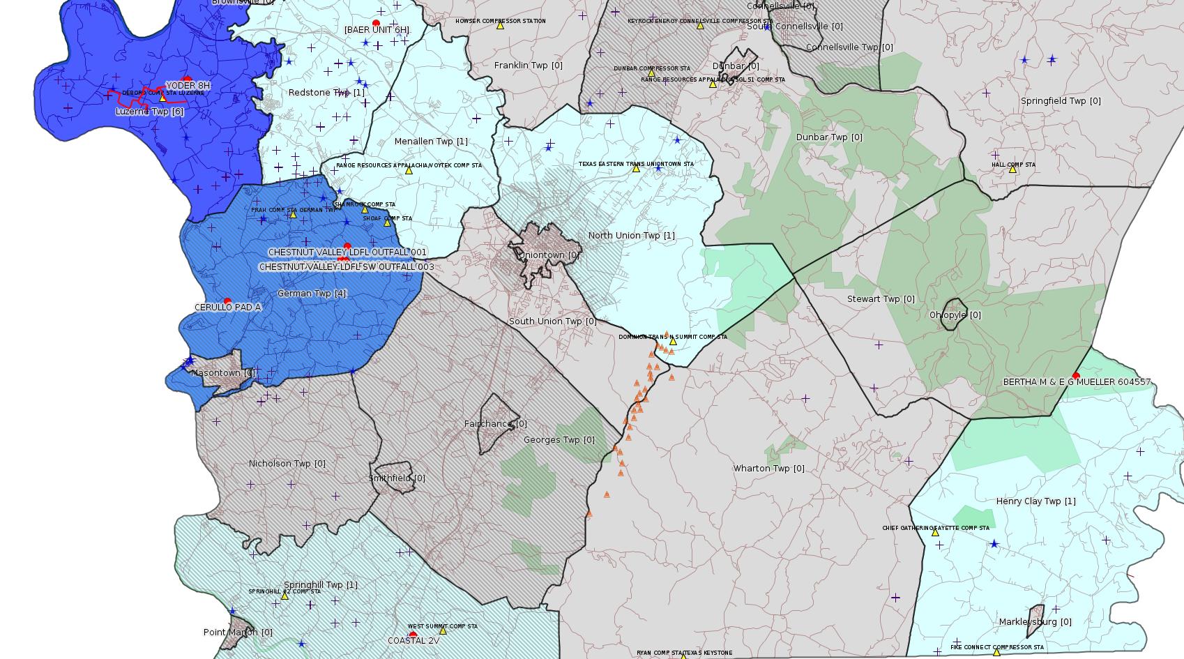
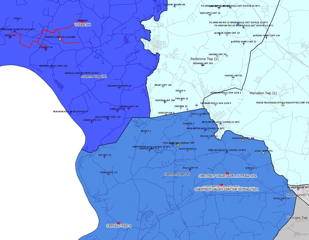
Fayette County Marcellus Shale Permits 6/18/18 - 7/1/18
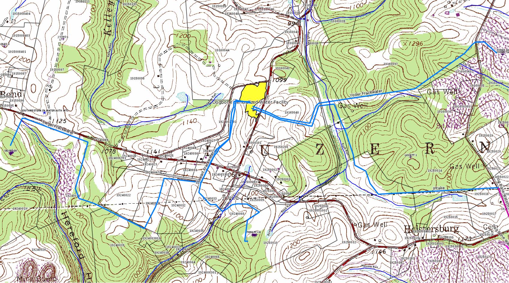
Click the map to enlarge
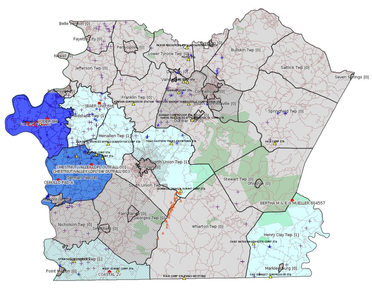
Map
Key
Red dots: items in this permit list with an exact location.
Blue stars: Marcellus Gas Well Water Sources.
Municipality shading: number of "facilities", with each well counting separately
(includes the red dots):
Red dots: items in this permit list with an exact location.
Blue stars: Marcellus Gas Well Water Sources.
Municipality shading: number of "facilities", with each well counting separately
(includes the red dots):
gray: 0
pale turquoise: 1
turquoise: 2
pale blue: 3
middle blue: 4
dark blue: 6
dark purple: 11
purple: 14
(Color coding may differ from one issue to the next.)
(Note if a project spans multiple municipalities -- e.g. a pipeline -- it will show in the count for each municipality.)
The number of facilities also follows the municipality name in brackets.
Municipality counts are based on the way the permit is listed by DEP; DEP has been known to get a municipality wrong.
Locations in brackets identify a precise location used to locate a surrogate for the actual site being permitted (e.g. locating a well pad or pipeline by the known location of a well.) Locations labeled beginning with "~" and ending in "[?]" are approximate and speculative based on inferences using on-line property and lease records. These are marked in the text as "[Approximate, Speculative]
Cross-hatching: Environmental Justice Areas
Yellow triangles: Compressor Stations
Orange triangles: Storage Field Wells (currently Dominion North Summit Storage Field)
Crosses: SPUD Unconventional well permits
Green: "Natural areas", e.g. state game lands, state forests
Yellow triangles: Compressor Stations
Orange triangles: Storage Field Wells (currently Dominion North Summit Storage Field)
Crosses: SPUD Unconventional well permits
Green: "Natural areas", e.g. state game lands, state forests
More Maps
 |
 |
 |
 |
Source: Pennsylvania Bulletin
RULES AND REGULATIONS
Title 25—ENVIRONMENTAL PROTECTION
ENVIRONMENTAL QUALITY BOARD
[ 25 PA. CODE CHS. 210 AND 211 ]
Handling and Use of Explosives
The Environmental Quality Board (Board) amends Chapters 210 and 211 (relating to blasters' licenses; and storage, handling and use of explosives) to read as set forth in Annex A. These amendments update the regulations based on current industry best practices and include blasting requirements related to seismic exploration.
This final-form rulemaking was adopted by the Board at its meeting of February 20, 2018.
<https://www.pabulletin.com/secure/data/vol48/48-25/959.html>
[The listing is extremely lengthy; for more information see the link above.]
---
Rescission of Technical Guidance
DEP ID: 550-2000-001. Title: Administrative Policy and Procedure Manual. Description: The Department is rescinding this technical guidance document because processes have significantly changed since the document was last revised in 1992. This technical guidance document contains policies and procedures to be followed by administrative and clerical staff in processing documents for the oil and gas management program that are no longer relevant.
Contact: Questions regarding this technical guidance document should be directed to Kurt Klapkowski at kklapkowski@pa.gov or (717) 783-9893.
Effective Date: June 30, 2018
PATRICK McDONNELL,
Secretary
<https://www.pabulletin.com/secure/data/vol48/48-26/1003.html>
-------------------------
Source: eNOTICE (+ PA Oil and Gas Mapping, Well Pad Report.) Well Details via Data Portal Services: Oil and Gas Wells All (ID: 3).
Please see the Disclaimer below regarding Parcel Id data.
New:
Authorization ID: 1234285
Permit number: ESX18-051-0006
Site: YODER WATERLINE ESCGP ESX18-051-0006
Client: CHEVRON APPALACHIA LLC
Authorization type: Expedited E&S Stormwater General Permit 1
Application type: New
Authorization is for: SITE
Date received: 06/25/2018
Status: Pending
Permit Decision Guarantee Applies?: Yes
Permit Decision Guarantee status: ACTIVE
<https://www.ahs.dep.pa.gov/eFACTSWeb/searchResults_singleAuth.aspx?AuthID=1234285>
Site Programs:
Municipalities:
Luzerne Twp, Fayette County
New:
Authorization ID: 1234198
Permit number: ESX11-051-0023
Site: BAER WELL SITES ESCGP-EXPEDITED
Client: CHEVRON APPALACHIA LLC
Authorization type: Expedited E&S Stormwater General Permit 1
Application type: Notification
Authorization is for: SITE
Date received: 06/25/2018
Status: Pending
Permit Decision Guarantee Applies?: No
Permit Review Notes:
Date Review Note
6/26/2018 The permit application package is complete, has been accepted, and is undergoing technical review.
<https://www.ahs.dep.pa.gov/eFACTSWeb/searchResults_singleAuth.aspx?AuthID=1234198>
Site Programs:
Oil & Gas
Municipalities:
Redstone Twp, Fayette County
Location [of BAER UNIT 6H]: 39.998708,-79.817186 <https://osm.org/go/ZWpep4uT--?m=>
Presumed Parcel Id: 30060203
[See Notes.]
New:
Authorization ID: 1234130
Permit number: GP08260718002
Site: YODER WATERLINE GP5 & GP8
Client: CHEVRON APPALACHIA LLC
Authorization type: GP-08 Temporary Road Crossings
Application type: New
Authorization is for: FACILITY
Date received: 06/21/2018
Status: Pending
Permit Decision Guarantee Applies?: No
Sub-Facilities for Authorization:
Sub-Facility ID Sub-Facility Name Description
1261250 YODER WATERLINE GP08260718-002 Bridge
Permit Review Notes:
Date Review Note
6/28/2018 The permit application package is complete, has been accepted, and is undergoing technical review.
<https://www.ahs.dep.pa.gov/eFACTSWeb/searchResults_singleAuth.aspx?AuthID=1234130>
Site Programs:
Water Planning and Conservation
Municipalities:
Luzerne Twp, Fayette County
New:
Authorization ID: 1234125
Permit number: GP05260718002
Site: YODER WATERLINE GP5 & GP8
Client: CHEVRON APPALACHIA LLC
Authorization type: GP-05 Utility Line Stream Crossings
Application type: New
Authorization is for: FACILITY
Date received: 06/21/2018
Status: Pending
Permit Decision Guarantee Applies?: Yes
Permit Decision Guarantee status: ACTIVE
Sub-Facilities for Authorization:
Sub-Facility ID Sub-Facility Name Description
1261249 YODER WATERLINE GP05260718-002 Pipeline or Conduit
Permit Review Notes:
Date Review Note
6/28/2018 The permit application package is complete, has been accepted, and is undergoing technical review.
<https://www.ahs.dep.pa.gov/eFACTSWeb/searchResults_singleAuth.aspx?AuthID=1234125>
Site Programs:
Water Planning and Conservation
Municipalities:
Luzerne Twp, Fayette County
New:
Authorization ID: 1233816
Permit number: ESX18-051-0005
Site: SIEGEL WATERLINE ESCGP ESX18-051-0005
Client: CHEVRON APPALACHIA LLC
Authorization type: Expedited E&S Stormwater General Permit 1
Application type: New
Authorization is for: SITE
Date received: 06/21/2018
Status: Pending
Permit Decision Guarantee Applies?: Yes
Permit Decision Guarantee status: ACTIVE
<https://www.ahs.dep.pa.gov/eFACTSWeb/searchResults_singleAuth.aspx?AuthID=1233816>
Site Programs:
Municipalities:
Luzerne Twp, Fayette County
Act 14 Notification: <http://faymarwatch.org/documents/SKM_554e18062908130.pdf>
[Conventional Well:]
Authorization ID: 1232919
Permit number: 051-20011
Site: BERTHA M & E G MUELLER 604557 WELL
Client: EQT PRODUCTION CO
Authorization type: Well Plugging Notice Intent to Plug Single Well
Application type: New
Authorization is for: FACILITY
Date received: 06/13/2018
Status: Issued on 6/13/2018
Permit Decision Guarantee Applies?: No
Sub-Facilities for Authorization:
Sub-Facility ID Sub-Facility Name Description
56218 BERTHA M & E G MUELLER 604557 Well
Permit Review Notes:
Date Review Note
6/13/2018 The technical review and decision review are complete and either the permit decision and/or permit issuance are forthcoming.
6/13/2018 The permit application package is complete, has been accepted, and is undergoing technical review.
<https://www.ahs.dep.pa.gov/eFACTSWeb/searchResults_singleAuth.aspx?AuthID=1232919>
Site Programs:
Oil & Gas
Municipalities:
Henry Clay Twp, Fayette County
Well Details:
Permit Number: 051-20011
Well Name: BERTHA M & E G MUELLER 604557
Unconventional Well: N
Well Configuration: Vertical Well
Well Type: GAS
Well Status: Active
Coal Association: NonCoal
Conservation Well: N
Primary Facility ID: 42688
Site ID: 40936
Site Name: BERTHA M & E G MUELLER 604557 WELL
Well Pad ID: 0
Well Pad Name:
Storage Field:
Operator: EQT PRODUCTION CO
Operator Number: OGO-61555
Permit Date: 1901-01-01
Permit Date Expires:
SPUD Date: 1959-08-29
Date Plugged:
UIC ID:
UIC Type:
Surface Elevation: 2825
County: Fayette
Municipality: Henry Clay Twp
Location: 39.84126,-79.42603
Map URL: <http://www.openstreetmap.org/?mlat=39.84126&mlon=-79.42603#map=15/39.84126/-79.42603>
Parcel Id: 16010001
Authorization ID: 1231002
Permit number: 051-24664
Site: COASTAL 1H FLOW BACK PIT FRESHWATER PITS ESCGP-EXPEDITED
Client: INR OPERATING LLC
Authorization type: Drill & Operate Well Permit (Conventional)
Application type: New
Authorization is for: FACILITY
Date received: 05/31/2018
Status: Issued on 6/26/2018
Permit Decision Guarantee Applies?: No
Sub-Facilities for Authorization:
Sub-Facility ID Sub-Facility Name Description
1259713 WELLBORE SURFACE HOLE LOCATION Well
Permit Review Notes:
Date Review Note
6/19/2018 The technical review and decision review are complete and either the permit decision and/or permit issuance are forthcoming.
6/15/2018 Applicant has been issued a deficiency letter. If applicable, this application no longer qualifies for the Permit Decision Guarantee.
6/5/2018 Applicant has been issued a deficiency letter. If applicable, this application no longer qualifies for the Permit Decision Guarantee.
<https://www.ahs.dep.pa.gov/eFACTSWeb/searchResults_singleAuth.aspx?AuthID=1231002>
Site Programs:
Oil & Gas
Municipalities:
Springhill Twp [an Environmental Justice Area], Fayette County
Well Details:
Permit Number: 051-24664
Well Name: COASTAL 2V
Unconventional Well: N
Well Configuration: Vertical Well
Well Type: GAS
Well Status: Active
Coal Association: Coal
Conservation Well: Y
Primary Facility ID: 826848
Site ID: 739525
Site Name: COASTAL 1H FLOW BACK PIT FRESHWATER PITS ESCGP-EXPEDITED
Well Pad ID: 147971
Well Pad Name: COASTAL WELL PAD
Storage Field:
Operator: INR OPERATING LLC
Operator Number: OGO-51036
Permit Date: 2018-06-26
Permit Date Expires: 2019-06-26
SPUD Date:
Date Plugged:
UIC ID:
UIC Type:
Surface Elevation: 1130
County: Fayette
Municipality: Springhill Twp
Location: 39.733336,-79.800886
Map URL: <http://www.openstreetmap.org/?mlat=39.733336&mlon=-79.800886#map=15/39.733336/-79.800886>
Presumed Parcel Id: 36210048
Application: <http://www.depgis.state.pa.us/eWellDocHandler/pdFHandler.ashx?Doc=NTYyNzU4>
Coal Status Report: <http://www.depgis.state.pa.us/eWellDocHandler/pdFHandler.ashx?Doc=NTYyNjA4>
Ownership & Control Info: <http://www.depgis.state.pa.us/eWellDocHandler/pdFHandler.ashx?Doc=NTYyNTgz>
Plat: <http://www.depgis.state.pa.us/eWellDocHandler/pdFHandler.ashx?Doc=NTYyNTY1>
Coordination with Public Resources:
<http://www.depgis.state.pa.us/eWellDocHandler/pdFHandler.ashx?Doc=NTYyNTM1>
PNDI: <http://www.depgis.state.pa.us/eWellDocHandler/pdFHandler.ashx?Doc=NTU5Mzk4>
PNDI Support Doc: <http://www.depgis.state.pa.us/eWellDocHandler/pdFHandler.ashx?Doc=NTU5Mzk5>
[For more information on this site see Notes in the 6/17/18 issue of this bulletin.]
Authorization ID: 1230405
Permit number: ESX18-051-0004
Site: CERULLO PAD A ESCGP ESX18-051-0004
Client: CHEVRON APPALACHIA LLC
Authorization type: Expedited E&S Stormwater General Permit 1
Application type: New
Authorization is for: SITE
Date received: 05/24/2018
Status: Pending
Permit Decision Guarantee Applies?: Yes
Permit Decision Guarantee status: VOID
Permit Review Notes:
Date Review Note
6/13/2018 Applicant has been issued a deficiency letter. If applicable, this application no longer qualifies for the Permit Decision Guarantee.
<https://www.ahs.dep.pa.gov/eFACTSWeb/searchResults_singleAuth.aspx?AuthID=1230405>
Site Programs:
Oil & Gas
Municipalities:
German Twp [an Environmental Justice Area], Fayette County
Well Pad Id: 155068
Wells on this Pad:
051-24650 CERULLO 1
Location: 39.879083,-79.902789 <https://osm.org/go/ZWpNvUhQ--?m=>
Presumed Parcel Id: 15190070
Authorization ID: 1221795
Permit number: ESG18-051-0001
Site: DOGBONE WATER LINE ESCGP ESG18-051-0001
Client: CHEVRON APPALACHIA LLC
Authorization type: Erosion and Sediment Control GP-2
Application type: New
Authorization is for: SITE
Date received: 03/22/2018
Status: Pending
Permit Decision Guarantee Applies?: Yes
Permit Decision Guarantee status: VOID
Permit Review Notes:
Date Review Note
6/15/2018 Applicant has been issued a deficiency letter. If applicable, this application no longer qualifies for the Permit Decision Guarantee.
<https://www.ahs.dep.pa.gov/eFACTSWeb/searchResults_singleAuth.aspx?AuthID=1221795>
Site Programs:
Municipalities:
Luzerne Twp, Fayette County
Authorization ID: 1219420
Permit number: GP052618203
Site: TEXAS EASTERN TRANSMISSION FAYETTE CNTY
Client: TEXAS EASTERN TRANS LP
Authorization type: GP-05 Utility Line Stream Crossings
Application type: New
Authorization is for: FACILITY
Date received: 03/01/2018
Status: Pending
Permit Decision Guarantee Applies?: Yes
Permit Decision Guarantee status: ACTIVE
Permit Review Notes:
Date Review Note
6/28/2018 The technical review and decision review are complete and either the permit decision and/or permit issuance are forthcoming.
4/25/2018 The permit application package is complete, has been accepted, and is undergoing technical review.
<https://www.ahs.dep.pa.gov/eFACTSWeb/searchResults_singleAuth.aspx?AuthID=1219420>
Site Programs:
Water Planning and Conservation
Municipalities:
German Twp [an Environmental Justice Area], Fayette County
Menallen Twp, Fayette County
North Union Twp, Fayette County
[Possibly off-topic:]
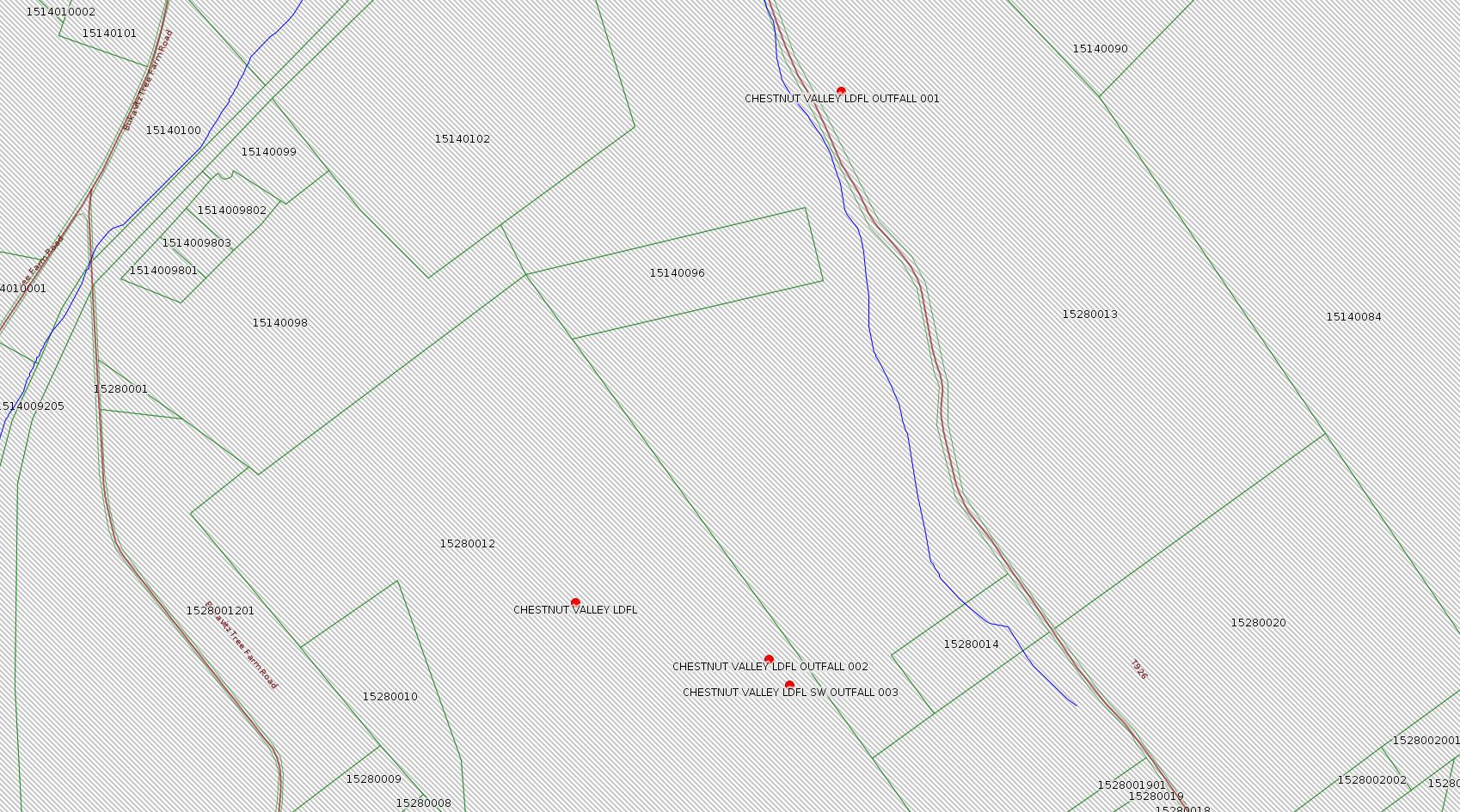
Authorization ID: 1204807
Permit number: 100419
Site: CHESTNUT VALLEY LDFL
Client: ADVANCED DSPL SVC CHESTNUT VALLEY LDFL INC
Authorization type: Landfill Pmt Final Construction Certification Form 37
Application type: Modification
Authorization is for: FACILITY
Date received: 10/31/2017
Status: Pending
Permit Decision Guarantee Applies?: Yes
Permit Decision Guarantee status: VOID
Permit Review Notes:
Date Review Note
6/21/2018 Applicant has been issued a deficiency letter. If applicable, this application no longer qualifies for the Permit Decision Guarantee.
12/27/2017 The permit application package is complete, has been accepted, and is undergoing technical review.
<https://www.ahs.dep.pa.gov/eFACTSWeb/searchResults_singleAuth.aspx?AuthID=1204807>
Site Programs:
Air Quality
Clean Water
Environmental Cleanup & Brownfields
Mining
Radiation Protection
Waste Management
Water Planning and Conservation
Municipalities:
German Twp [an Environmental Justice Area], Fayette County
Location: 39.896765,-79.838766 <http://osm.org/go/ZWpP0~XK--?m=>
Presumed Parcel Id: 15280012
[Possibly off-topic:]
Authorization ID: 1187805
Permit number: PA0090948
Site: CHESTNUT VALLEY LDFL
Client: ADVANCED DSPL SVC CHESTNUT VALLEY LDFL INC
Authorization type: Minor IW Facility with ELG
Application type: Renewal
Authorization is for: FACILITY
Date received: 06/12/2017
Status: Pending
Permit Decision Guarantee Applies?: No
Sub-Facilities for Authorization:
Sub-Facility ID Sub-Facility Name Description
212046 OUTFALL 001 Discharge Point
Location: 39.902222,-79.835
Map URL: <http://www.openstreetmap.org/?mlat=39.902222&mlon=-79.835#map=15/39.902222/-79.835>
Presumed Parcel Id: 15280013
568839 OUTFALL 002 Discharge Point
Location: 39.896111,-79.836111
Map URL: <http://www.openstreetmap.org/?mlat=39.896111&mlon=-79.836111#map=15/39.896111/-79.836111>
Presumed Parcel Id: 15280012
568840 SW OUTFALL 003 Discharge Point
Location: 39.895833,-79.835833
Map URL: <http://www.openstreetmap.org/?mlat=39.895833&mlon=-79.835833#map=15/39.895833/-79.835833>
Presumed Parcel Id: 15280012
Permit Review Notes:
Date Review Note
10/31/2017 The permit application package is complete, has been accepted, and is undergoing technical review.
<https://www.ahs.dep.pa.gov/eFACTSWeb/searchResults_singleAuth.aspx?AuthID=1187805>
Site Programs:
Air Quality
Clean Water
Environmental Cleanup & Brownfields
Mining
Radiation Protection
Waste Management
Water Planning and Conservation
Municipalities:
German Twp [an Environmental Justice Area], Fayette County
-------------------------
Source: DEP Oil and Gas Electronic Notifications
NOTIFICATION_ID: 41762
OGO: 39307
OPERATOR: CHEVRON APPALACHIA LLC
API_PERMIT: 051-24659
SPUD_DATE: 05/07/2018
COUNTY: Fayette
MUNICIPALITY: Luzerne
LATITUDE: 39.9754
LONGITUDE: -79.923886
SUBJECT: [NOTIFICATION]: Casing cementing notification 58 Pa. C.S. 3211(f)(2) for well API 37-051-24659-00-00
QUESTION: Enter the Date and Time for the applicable Casing Types
ANSWER: Intermediate: 6/26/2018 12:00:00 AM
SENT_DATE: 6/19/2018 1:20:04 PM
SENT_SUCCESS: Yes
LAST_RESENT_DATE:
RESENT_SUCCESS:
Well Details:
Permit Number: 051-24659
Well Name: YODER 8H
Unconventional Well: Y
Well Configuration: Horizontal Well
Well Type: GAS
Well Status: Active
Coal Association: NonCoal
Conservation Well: N
Primary Facility ID: 824633
Site ID: 790607
Site Name: YODER WELL PAD ESCGP-2 EXPEDITED
Well Pad ID: 153100
Well Pad Name: YODER
Storage Field:
Operator: CHEVRON APPALACHIA LLC
Operator Number: OGO-39307
Permit Date: 2018-03-06
Permit Date Expires: 2019-03-06
SPUD Date: 2018-05-07
Date Plugged:
UIC ID:
UIC Type:
Surface Elevation: 1118
County: Fayette
Municipality: Luzerne Twp
Location: 39.9754,-79.923886
Map URL: <http://www.openstreetmap.org/?mlat=39.9754&mlon=-79.923886#map=15/39.9754/-79.923886>
Presumed Parcel Id: 19160034
NOTIFICATION_ID: 41760
OGO: 39307
OPERATOR: CHEVRON APPALACHIA LLC
API_PERMIT: 051-24659
SPUD_DATE: 05/07/2018
COUNTY: Fayette
MUNICIPALITY: Luzerne
LATITUDE: 39.9754
LONGITUDE: -79.923886
SUBJECT: [NOTIFICATION]: Casing cementing notification 58 Pa. C.S. 3211(f)(2) for well API 37-051-24659-00-00
QUESTION: Enter the Date and Time for the applicable Casing Types
ANSWER: Surface: 6/24/2018 12:00:00 PM
SENT_DATE: 6/19/2018 11:32:27 AM
SENT_SUCCESS: Yes
LAST_RESENT_DATE:
RESENT_SUCCESS:
[Well Details above.]
NOTIFICATION_ID: 41755
OGO: 39307
OPERATOR: CHEVRON APPALACHIA LLC
API_PERMIT: 051-24659
SPUD_DATE: 05/07/2018
COUNTY: Fayette
MUNICIPALITY: Luzerne
LATITUDE: 39.9754
LONGITUDE: -79.923886
SUBJECT: [NOTIFICATION]: Drilling resumption After Break of 30 days or more notification 58 Pa. C.S. 3211(f)(1) for well API 37-051-24659-00-00
QUESTION: Date and approximate time action is to occur
ANSWER: Date: 06/24/2018 Time: 12:00am
SENT_DATE: 6/19/2018 8:59:07 AM
SENT_SUCCESS: Yes
LAST_RESENT_DATE:
RESENT_SUCCESS:
[Well Details above.]
-------------------------
Source: Reuters Commodities: Energy
Natural Gas
| Commodity | Exchange | Currency | Expire | Last Trade | Trade Time | Change | Open | Day's High | Day's Low |
|---|---|---|---|---|---|---|---|---|---|
| NATURAL
GAS CON1 Jul18 |
NYM | USD | 07/27 | 2.89 | 07/02 04:02 | -0.03 | 2.92 | 2.93 | 2.89 |
<http://www.reuters.com/finance/commodities/energy>
-------------------------
Notes:
The notice for Authorization 1234198 above is no less than Chevron's third try for what appears to be a "termination notice" for the Erosion & Sedimentation Permit for the Baer Well Pad. (No wells were actually drilled on this pad.) See the 5/20/18 issue of this bulletin for more information about this site.
------------------------
DEP defines an environmental justice area as "any census tract where 20 percent or more individuals live in poverty, and/or 30 percent or more of the population is minority". (See:
<http://www.dep.pa.gov/PublicParticipation/OfficeofEnvironmentalJustice/Pages/default.aspx>). There are supposed to be enhanced public participation requirements for permits in environmental justice areas, but news of this actually ever happening is scarce. In Fayette County, the entirety of Springhill, Nicholson, German, and Georges Townships are environmental justice areas, as well as a large part of Dunbar Township. DEP's policy document on public participation guidelines for environmental justice areas is located here:
<http://www.elibrary.dep.state.pa.us/dsweb/Get/Version-48671/012-0501-002.pdf>
eNOTICE records are likely to list the same permit multiple times, as that permit moves through the DEP process.
Oil & Gas Wells designated with a site a number and the letter H typically designate horizontal wells.
-------------------------
Resources:
Pennsylvania Bulletin: <http://www.pabulletin.com/>
eNOTICE: <http://www.ahs2.dep.state.pa.
DEP Oil and Gas Reports: <http://www.dep.pa.gov/DataandTools/Reports/Oil%20and%20Gas%20Reports/Pages/default.aspx>
DEP Permits Issued Detail Report:
<http://www.depreportingservic
DEP SPUD (drilling started) Report:
<http://www.depreportingservices.state.pa.us/ReportServer/Pages/ReportViewer.aspx?/Oil_Gas/Spud_External_Data>
DEP Oil and Gas Compliance Report:
<http://www.depreportingservices.state.pa.us/ReportServer/Pages/ReportViewer.aspx?/Oil_Gas/OG_Compliance>
DEP PA Oil & Gas Mapping:
<http://www.depgis.state.pa.us/PaOilAndGasMapping>
Data Portal Services Directory [Technical]
<http://www.depgis.state.pa.us/arcgis/rest/services>
Query: Oil and Gas Wells All (ID: 3) [Technical]:
<http://www.depgis.state.pa.us/arcgis/rest/services/OilGas/OilGasAllStrayGas/MapServer/3/query?where=&text=&objectIds=&time=&geometry=&geometryType=esriGeometryEnvelope&inSR=&spatialRel=esriSpatialRelIntersects&relationParam=&outFields=*&returnGeometry=true&returnTrueCurves=false&maxAllowableOffset=&geometryPrecision=&outSR=&returnIdsOnly=false&returnCountOnly=false&orderByFields=&groupByFieldsForStatistics=&outStatistics=&returnZ=false&returnM=false&gdbVersion=&returnDistinctValues=false&resultOffset=&resultRecordCount=&f=html>
(Be sure to enter a Where clause in SQL format. Dates are in milliseconds since midnight 1/1/1970).
New:
DEP Oil and Gas Electronic Submissions
<http://www.ahs.dep.pa.gov/eSubmissionPublicSearch>
DEP Oil and Gas Electronic Notifications
<http://www.depreportingservices.state.pa.us/ReportServer?/Oil_Gas/OG_Notifications>
DEP Oil and Gas Well Pad Report
<http://www.depreportingservices.state.pa.us/ReportServer?/Oil_Gas/Well_Pads>
Fayette County Assessment Office Search For Tax Records:
<http://property.co.fayette.pa.us/search.aspx>
Pennsylvania Spatial Data Access:
<http://www.pasda.psu.edu/default.asp>
DEP Spatial Data Repository:
<ftp://www.pasda.psu.edu/pub/pasda/dep/>
National Response Center:
<http://www.nrc.uscg.mil/>
EPA-Echo: <http://www.epa-echo.gov/echo/
FERC citizen involvement: <http://www.ferc.gov/for-citiz
To receive E-mail notification of
all documents filed in a FERC docket, see:
<http://www.ferc.gov/docs-filing/esubscription.asp >
<http://www.ferc.gov/docs-fili
Follow the directions and enter the docket number to subscribe to.
Township Supervisors receive information regarding Erosion & Sedimentation permits, and these records may be reviewable at township municipal offices.
DEP permits are reviewable through the File Review process, for application to do file review see: <http://www.portal.state.pa.us/portal/server.pt/community/southwest_regional_office/13775/file_review/593164>
Environmental Hearing Board: <http://ehb.courtapps.com/publ
PA DEP Environmental Policy Comment System:
<http://www.ahs.dep.pa.gov/eComment/>
Federal Register Environment: <https://www.federalregister.g
Browsing of recent comment
opportunities for federal agencies, e.g. EPA. Click "sign up" to
subscribe to daily E-mails of new document listings.
SkyTruth Fayette County Drilling Alerts: <http://frack.skytruth.org/pen
U.S. Army Corps of Engineers, Pittsburgh District, Public Notices:
<http://www.lrp.usace.army.mil/Missions/Regulatory/Public-Notices/>
EPA Pennsylvania Public Notices: <http://www2.epa.gov/aboutepa/epa-pennsylvania#notice>
Marcellus Shale waste disposal
injection wells in Pennsylvania are regulated directly by EPA, not
DEP. Notice of any new permit applications will appear at the
above web address. I'm not aware of any subscription service
to be notified of such applications. I'm not aware of any
Marcellus Shale waste disposal injection wells in Fayette County
(yet ...) but we need to monitor this page for future
applications.
Energy Assurance Daily: <http://www.oe.netl.doe.gov/ead.aspx>
Daily newsletter from the US
Department of Energy about events relating to energy. The Natural
Gas section has information about pipelines.
-------------------------
Disclaimers:
This compilation from the above sources was done in part by hand using copy and paste and in part using automated methods; it may omit relevant permits.
Parcel data is provided via the tax records search web page offered by the Fayette County Assessment Office (http://property.co.fayette.pa.us/). Presumed Parcel Id links are subject to availability provided by that agency and associated web sites. Presumed Parcel Ids are determined as the mapped parcel containing a given latitude and longitude, are a best effort determination which is subject to error, and are not official. In cases where a facility is leased and there is a separate parcel id for the lease, if this parcel id is not separately mapped, the parcel id shown will be the id for the enclosing parcel. Parcel owners may be surface owners only and may or may not have any relationship to oil & gas facilities.
Does not currently include water supply permits. Does not include landfill permits even though many such are for Marcellus Shale waste. (It is not possible at this time to distinguish which landfill permits are for Marcellus Shale waste and which are not without doing File Review for each permit.)
Erosion & Sedimentation permit records do not currently include latitude and longitude. Where I am publishing latitude and longitude with E&S permits it is by inferring an associated well permit and using published latitude and longitude for the well. It is possible I may be inferring the wrong well site.
Municipalities are shown from eFACTS records on the DEP web site. The DEP has been known to list a municipality incorrectly.