The Harmed Success Stories Concepts How To What Is Commentary
Fayette County Marcellus Shale Permits 4/19/21 - 5/2/21
Contents
Pennsylvania Bulletin Listings
Texas Eastern Transmission Uniontown Crossover State Water Quality CertificationeFACTS Listings
JACKSON FARMS UNIT 37H, 38H, 39H Residual Waste Processing ["Previously Approved" Defoamer] (look-ahead to 5/4/21)
TEXAS EASTERN TRANS FAYETTE CNTY BWM-GP-11 Maintenance, Testing, Repair, Rehabilitation or Replacement General Pmt (New)
CHESTNUT VALLEY LDFL PAG-03 Discharge of Stormwater Assoc w Industrial Activities Transfer
NORTH SUMMIT COMP STA Major Facility Operating Permit Amendment Issued 4/21/2021
DOGBONE WATER LINE Erosion and Sediment Control GP-2 [Termination?] Notification Denied 4/23/2021
Yoder Well Connect Erosion and Sediment Control General Permit 3 [Termination?] Notification Issued 4/15/2021
NORTH SUMMIT COMP STA Major Facility Operating Permit Renewal Issued 4/21/2021
Inspection Issues
WEIRTON COAL 1 Detached wellhead, leaking gas; Violation(s) NotedPrice of Natural Gas
FILCHOCK 2 leaking from the separator; Violation(s) Noted
(SARA GORLEY ML&HCO)A G MILLER EST 963 Failure to plug the well upon abandoning it; Violation(s) Noted
Unconventional Wells with failures to file reports (tabulated)
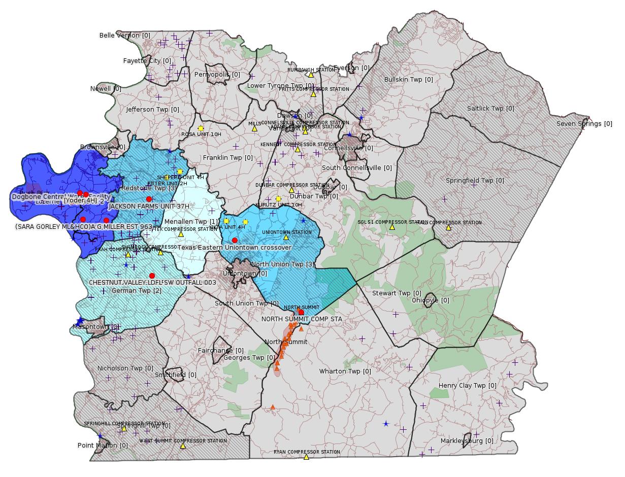
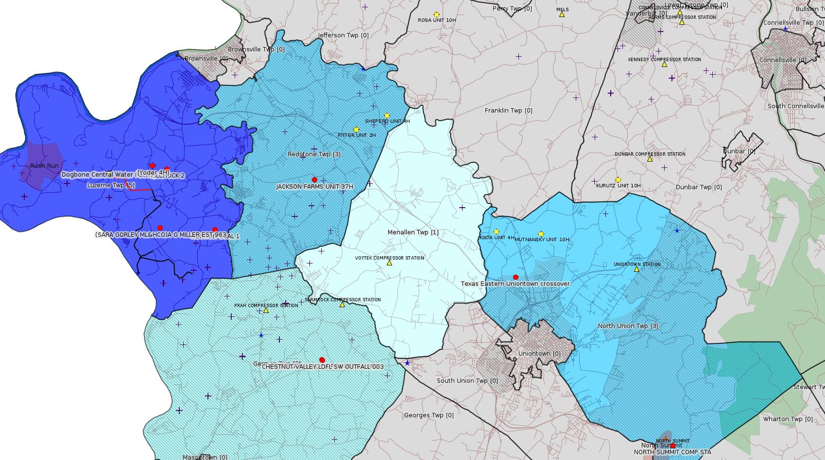
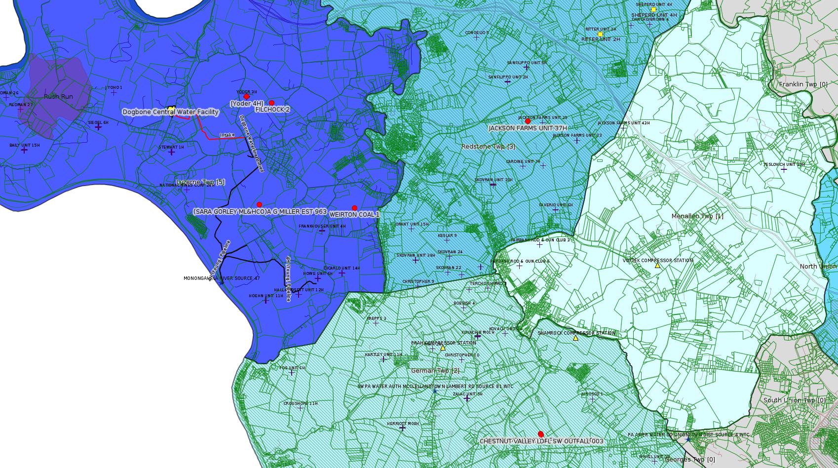
Map
Key
Red dots: items in this permit list with an exact location.
Blue stars: Marcellus Gas Well Water Sources.
Where well laterals are mapped they show in red; a 400-foot buffer surrounding the lateral shows in blue (lavender where it overlaps a mapped mineral tract).
Where mineral tracts are mapped, they show in pink. Mineral tracts can overlap; the overlap will show in red. The precise meaning of "mineral tract" is not clear.
Municipality shading: number of "facilities", with each well counting separately
(includes the red dots):
gray: 0
pale turquoise: 1
turquoise: 2
pale blue: 3
middle blue: 4
dark blue: 5
dark purple: 7
purple: 9
(Color coding may differ from one issue to the next.)
(Note if a project spans multiple municipalities -- e.g. a pipeline -- it will show in the count for each municipality.)
The number of facilities also follows the municipality name in brackets.
Municipality counts are based on the way the permit is listed by DEP; DEP has been known to get a municipality wrong.
Locations in brackets identify a precise location used to locate a surrogate for the actual site being permitted (e.g. locating a well pad or pipeline by the known location of a well.) Locations labeled beginning with "~" and ending in "[?]" are approximate and speculative based on inferences using on-line property and lease records. These are marked in the text as "[Approximate, Speculative]
Cross-hatching: Environmental Justice Areas
Yellow triangles: Compressor Stations
Orange triangles: Storage Field Wells (currently Dominion North Summit Storage Field)
Crosses: SPUD Unconventional well permits
Green: "Natural areas", e.g. state game lands, state forests
Yellow triangles: Compressor Stations
Orange triangles: Storage Field Wells (currently Dominion North Summit Storage Field)
Crosses: SPUD Unconventional well permits
Green: "Natural areas", e.g. state game lands, state forests
More Maps
 |
 |
Source: Pennsylvania Bulletin
WQ6583220-002, Texas Eastern Transmission, LP, 890 Winter Street, Suite 300, Waltham, MA 02451. Appalachia to Market Project, in North Union Township of Fayette County, Salem Township of Westmoreland County, Pike Township of Berks County, Philadelphia and Pittsburgh Corps Districts. The proposed project will involve the following system modifications:
• Bechtelsville crossover: Install full crossover from Texas Eastern Lines 28/27 to Texas Eastern Lines 19/12 at milepost (MP) 218.81 (beginning of Line 28 loop) in Berks County, PA (Coordinates: 40° 24` 50.54", -75° 42` 27.03");
• Uniontown crossover: Install full crossover from Texas Eastern Lines 30/25 to Texas Eastern Lines 10/15 at MP 771.05 (end of Line 30 loop) in Fayette County, PA (Coordinates: 39° 55` 42.75", -79° 44` 01.41"); and
• Delmont loop: Install approximately 1.1 miles of 30-inch diameter pipeline in same trench as abandoned 30-inch diameter Line 27 downstream from the Delmont Compressor Station in Westmoreland County, PA (Project Center Coordinates: 40° 23` 18.55", -79° 32` 08.62").
On May 1, 2020, Applicant filed an application with the Federal Energy Regulatory Commission (FERC) under Section 7 of the Natural Gas Act (15 U.S.C.A. § 717f) seeking a certificate of public convenience and necessity to construct and operate its Project (FERC Docket No. CP20-436-000). The FERC Environmental Assessment for the Project, which was issued on September 15, 2020, may be viewed on FERC's website at www.ferc.gov (search eLibrary; Docket Search; CP20-436-000).
On July 1, 2020, Applicant requested a state water quality certification (SWQC) from the Pennsylvania Department of Environmental Protection (PADEP), as required by Section 401 of the Clean Water Act (33 U.S.C.A. § 1341), to ensure that the construction, operation and maintenance of the Project will protect water quality in Pennsylvania consistent with the requirements of State law and the Clean Water Act.
The Project, as proposed, will provide necessary pipeline infrastructure to enhance and increase the capacity and allow for incremental growth to residential and commercial customers; the project will deliver 18,000 Dth/d of supply to an existing delivery point. The Project, as proposed, will require approximately 18.0 acres of earth disturbance, and impacts to 181 linear feet of UNTs to Beaver Run (HQ-CWF), 0.541 acre of UNTs to Beaver Run (HQ-CWF) floodway, 0.04 acre of UNT to Pine Creek (EV, MF) floodway, 0.01 acre of temporary impacts to Exceptional Value (EV) Palustrine Emergent (PEM) wetlands, 0.27 acre of temporary impacts to Other (O) PEM wetlands, and 0.06 acre of permanent impacts to O PEM wetlands.
PADEP published notice of its proposed SWQC in the Pennsylvania Bulletin on November 21, 2020 (50 Pa.B. 6679) and has received no comments.
PADEP certifies that the construction, operation and maintenance of the Project complies with the applicable provisions of sections 301—303, 306 and 307 of the Federal Clean Water Act (33 U.S.C.A. §§ 1311—1313, 1316 and 1317). The PADEP further certifies that the construction, operation and maintenance of the Project complies with Pennsylvania water quality standards and that the construction, operation and maintenance of the Project will maintain and protect applicable Commonwealth water quality standards provided that the construction, operation and maintenance of the project complies with the following PADEP water quality permitting programs, criteria and conditions established pursuant to Pennsylvania law:
1. Discharge of Hydrostatic Test Water—Applicant shall obtain and comply with a National Pollutant Discharge Elimination System (NPDES) permit(s) for the discharge of water from the hydrostatic testing of the pipeline associated with the Project pursuant to Pennsylvania's Clean Streams Law (35 P.S. §§ 691.1—691.1001), 25 Pa. Code Chapter 92a (relating to NPDES permitting, monitoring and compliance), and all other applicable regulations.
2. Erosion and Sediment Control and Stormwater Management—All projects proposing earth disturbance must implement best management practices (BMPs) to protect and maintain water quality pursuant to Pennsylvania's Clean Streams Law (35 P.S. §§ 691.1—691.1001) and Storm Water Management Act (32 P.S. §§ 680.1—680.17), 25 Pa. Code Chapter 102 (relating to erosion and sediment control), and all other applicable regulations. Applicant shall obtain and comply with an Erosion and Sediment Control Permit(s) for earth disturbance associated with the Project as provided in 25 Pa. Code § 102.5.
3. Water Obstruction and Encroachment Permits—Applicant shall obtain and comply with a Water Obstruction and Encroachment Permit(s) for the construction, operation and maintenance of all stream and wetland crossings associated with the Project pursuant to Pennsylvania's Clean Streams Law, Dam Safety and Encroachments Act (32 P.S. §§ 693.1—693.27), and Flood Plain Management Act (32 P.S. §§ 679.101—679.601), 25 Pa. Code Chapter 105 (relating to dam safety and waterway management), 25 Pa. Code Chapter 106 (relating to floodplain management), and all other applicable regulations.
4. Other Water Quality Requirements—Applicant shall obtain any other permits, authorizations or approvals required to construct, operate, and maintain the Project from any interstate or international agency as required by an interstate compact or international agreement that has established water quality standards applicable to surface waters of this Commonwealth, including wetlands.
5. Water Quality Monitoring—PADEP retains the right to specify additional studies or monitoring to ensure that water quality in the receiving waters associated with the Project is not adversely impacted by any operational and construction process that may be employed by Applicant.
6. Operation—At all times, Applicant shall properly operate and maintain all Project facilities and systems of treatment and control (and related appurtenances) installed to achieve compliance with the terms and conditions of this SWQC and all required permits, authorizations and approvals. Proper operation and maintenance includes adequate laboratory controls, appropriate quality assurance procedures, and the operation of backup or auxiliary facilities or similar systems installed by Applicant.
7. Inspection—The Project, including all relevant records, are subject to inspection at reasonable hours and intervals by an authorized representative of PADEP or the delegated County Conservation District to determine compliance with this SWQC, including all permits, authorizations or approvals issued to ensure the project shall maintain and protect state water quality standards as required by this SWQC. Applicant shall provide a copy of this SWQC to an authorized representative conducting an inspection of the Project.
8. Transfer of Projects—If Applicant intends to transfer any legal or equitable interest in the Project or any portion(s) thereof, Applicant shall provide a copy of this SWQC and copies of any permits, authorizations or approvals obtained to comply with the SWQC upon the prospective transferee of the legal and equitable interest at least thirty (30) days prior to the contemplated transfer and shall simultaneously inform the appropriate PADEP Office of such intent. Notice to PADEP shall include a transfer agreement signed by the existing and new owners containing a specific date for transfer of responsibility, coverage, and liability under the SWQC and any permits, authorizations and approvals obtained to comply with the SWQC. The new owner shall submit to PADEP a new application form for the SWQC and any permits, authorizations and approvals required to comply with the SWQC signed by the new owner.
9. Correspondence—All correspondence with and submittals to PADEP concerning this SWQC shall be addressed to Department of Environmental Protection, Regional Permit Coordination Office, Domenic Rocco, PE, Director, 400 Market Street, Harrisburg, PA 17101, RA-EPREGIONALPERMIT@pa.gov.
10. Reservation of Rights—PADEP may modify, suspend or revoke this SWQC if (i) PADEP becomes aware of new facts about the Project that warrant such action; or (ii) PADEP determines that Applicant has not complied with the terms and conditions of this SWQC. PADEP may require additional measures to achieve compliance with any applicable law or regulation.
11. Other Laws—Nothing in this SWQC shall be construed to preclude the institution of any legal action or to relieve Applicant from any responsibilities, liabilities, or penalties established pursuant to any applicable law or regulation.
12. Severability—The provisions of this SWQC are severable and should any provision of this SWQC be declared invalid or unenforceable, the remainder of the SWQC shall not be affected thereby.
Any person aggrieved by this action may file a petition for review pursuant to Section 19(d) of the Federal Natural Gas Act, 15 U.S.C.A. § 717r(d), with the Office of the Clerk, United States Court of Appeals for the Third Circuit, 21400 U.S. Courthouse, 601 Market Street, Philadelphia, PA 19106-1790 as provided by law. This paragraph does not, in and of itself, create a right of appeal beyond that permitted by applicable statutes and decisional law. Important legal rights are at stake, so you should show this document to a lawyer promptly.
<http://www.pacodeandbulletin.gov/Display/pabull?file=/secure/pabulletin/data/vol51/51-18/672c.html&continued=http://www.pacodeandbulletin.gov/Display/pabull?file=/secure/pabulletin/data/vol51/51-18/672.html&d=reduce>
Location: 39.928542,-79.733725
Municipality: North Union Twp
Presumed Parcel Id: 25060136
[See Notes.]
-------------------------
Please see the Disclaimer below regarding Parcel Id data.
Authorization ID: 1352805
Permit number:
Site: JACKSON FARMS 30 OG WELL
Client: EQT CHAP LLC
Authorization type: Residual Waste Processing ["Previously Approved" Defoamer -jr]
Application type: New
Authorization is for: FACILITY
Date received: 05/04/2021
Status: Pending
Permit Decision Guarantee Applies: Yes
Permit Decision Guarantee status: ACTIVE
Permit Review Notes:
Date Review Note
5/4/2021 The technical review and decision review are complete and either the permit decision and/or permit issuance are forthcoming.
5/4/2021 The permit application package is complete, has been accepted, and is undergoing technical review.
<https://www.ahs.dep.pa.gov/eFACTSWeb/searchResults_singleAuth.aspx?AuthID=1352805>
Site Programs:
Oil & Gas
Site Municipalities:
Redstone Twp, Fayette County
Application for Approval of Previously Approved Alternative Waste Management Practices:
<https://www.ahs.dep.pa.gov/eSubmissionsDocs/DownloadESubmissionDocument.ashx?enc=MOpmV6IzBtmToVjqF07C9ZeKtiWfGytvPEBkJM%2fW%2b3I%3d>
[The above link appears to be malformed PDF, causing several different PDF viewers to fail to open it. For an unofficial screen-capture version, see:
<https://www.faymarwatch.org/documents/Jackson_Farms_A_-_Defoamer_OG-71B_screen_captured.pdf>
Previously Approved Authorization: 1343322
Previous Application:<https://www.ahs.dep.pa.gov/eSubmissionsDocs/DownloadESubmissionDocument.ashx?enc=MOpmV6IzBtmToVjqF07C9a7LE85BVt0jaZRmQPD5WEg%3d>
[See Notes.]
Well Details:
Permit Number: 051-24369
Well Name: JACKSON FARMS UNIT 37H
Unconventional Well: Y
Well Configuration: Horizontal Well
Well Type: GAS
Well Status: Active
Coal Association: Coal
Conservation Well: Y
Primary Facility ID: 731806
Site ID: 720740
Site Name: JACKSON FARMS 30 OG WELL
Well Pad ID: 148606
Well Pad Name: JACKSON FARMS UNIT 37H
Storage Field:
Operator: EQT CHAP LLC
Operator Number: OGO-39307
Permit Date: 2010-06-30
Permit Date Expires: 2011-06-30
SPUD Date: 2010-08-05
Date Plugged:
UIC ID:
UIC Type:
Surface Elevation: 1210
County: Fayette
Municipality: Redstone Twp
Location: 39.969078,-79.838689
Map URL: <http://www.openstreetmap.org/?mlat=39.969078&mlon=-79.838689#map=15/39.969078/-79.838689>
Presumed Parcel Id: 30310028
Well Details:
Permit Number: 051-24373
Well Name: JACKSON FARMS UNIT 38H
Unconventional Well: Y
Well Configuration: Horizontal Well
Well Type: GAS
Well Status: Active
Coal Association: Coal
Conservation Well: Y
Primary Facility ID: 731832
Site ID: 720740
Site Name: JACKSON FARMS 30 OG WELL
Well Pad ID: 148606
Well Pad Name: JACKSON FARMS UNIT 37H
Storage Field:
Operator: EQT CHAP LLC
Operator Number: OGO-39307
Permit Date: 2010-07-08
Permit Date Expires: 2011-07-08
SPUD Date: 2010-08-11
Date Plugged:
UIC ID:
UIC Type:
Surface Elevation: 1210
County: Fayette
Municipality: Redstone Twp
Location: 39.969081,-79.838631
Map URL: <http://www.openstreetmap.org/?mlat=39.969081&mlon=-79.838631#map=15/39.969081/-79.838631>
Well Details:
Permit Number: 051-24372
Well Name: JACKSON FARMS UNIT 39H
Unconventional Well: Y
Well Configuration: Horizontal Well
Well Type: GAS
Well Status: Active
Coal Association: Coal
Conservation Well: Y
Primary Facility ID: 731843
Site ID: 720740
Site Name: JACKSON FARMS 30 OG WELL
Well Pad ID: 148606
Well Pad Name: JACKSON FARMS UNIT 37H
Storage Field:
Operator: EQT CHAP LLC
Operator Number: OGO-39307
Permit Date: 2010-07-08
Permit Date Expires: 2011-07-08
SPUD Date: 2010-08-12
Date Plugged:
UIC ID:
UIC Type:
Surface Elevation: 1210
County: Fayette
Municipality: Redstone Twp
Location: 39.969081,-79.838603
Map URL: <http://www.openstreetmap.org/?mlat=39.969081&mlon=-79.838603#map=15/39.969081/-79.838603>
---
Authorization ID: 1349958
Permit number: GP112605221-010
Site: TEXAS EASTERN TRANS FAYETTE CNTY
Client: TEXAS EASTERN TRANS LP
Authorization type: BWM-GP-11 Maintenance, Testing, Repair, Rehabilitation or Replacement General Pmt
Application type: New
Authorization is for: FACILITY
Date received: 04/08/2021
Status: Pending
Permit Decision Guarantee Applies: Yes
Permit Decision Guarantee status: VOID
<https://www.ahs.dep.pa.gov/eFACTSWeb/searchResults_singleAuth.aspx?AuthID=1349958>
Site Programs:
Water Planning and Conservation
Site Municipalities:
German Twp, Fayette County
Menallen Twp, Fayette County
North Union Twp, Fayette County
---
Authorization ID: 1346845
Permit number: PAG036257
Site: CHESTNUT VALLEY LDFL
Client: CHESTNUT VALLEY LDFL LLC
Authorization type: PAG-03 Discharge of Stormwater Assoc w Industrial Activities
Application type: Transfer
Authorization is for: FACILITY
Date received: 03/03/2021
Status: Pending
Permit Decision Guarantee Applies: No
Sub-Facilities for Authorization:
Sub-Facility ID Sub-Facility Name Description
989305 SW OUTFALL 003 Internal Monitoring Point
989304 OUTFALL 002 Internal Monitoring Point
568840 SW OUTFALL 003 Discharge Point
Location: 39.895833,-79.835833
Map URL: <http://www.openstreetmap.org/?mlat=39.895833&mlon=-79.835833#map=15/39.895833/-79.835833>
989303 OUTFALL 001 Internal Monitoring Point
568839 OUTFALL 002 Discharge Point
Location: 39.896111,-79.836111
Map URL: <http://www.openstreetmap.org/?mlat=39.896111&mlon=-79.836111#map=15/39.896111/-79.836111>
Permit Review Notes:
Date Review Note
4/29/2021 The technical review and decision review are complete and either the permit decision and/or permit issuance are forthcoming.
3/25/2021 The permit application package is complete, has been accepted, and is undergoing technical review.
<https://www.ahs.dep.pa.gov/eFACTSWeb/searchResults_singleAuth.aspx?AuthID=1346845>
Site Programs:
Air Quality
Clean Water
Environmental Cleanup & Brownfields
Mining
Radiation Protection
Waste Management
Water Planning and Conservation
Site Municipalities:
German Twp, Fayette County
Presumed Parcel Id: 15280012
---
Authorization ID: 1336198
Permit number: 26-00405
Site: NORTH SUMMIT COMP STA
Client: EASTERN GAS TRANS & STORAGE INC
Authorization type: Major Facility Operating Permit
Application type: Amendment
Authorization is for: FACILITY
Date received: 12/03/2020
Status: Issued on 4/21/2021
Permit Decision Guarantee Applies: No
Sub-Facilities for Authorization:
Sub-Facility ID Sub-Facility Name Description
234592 ENGINE 1 COOPER 3200 HP Process
Permit Review Notes:
Date Review Note
4/21/2021 The technical review and decision review are complete and either the permit decision and/or permit issuance are forthcoming.
12/11/2020 The permit application package is complete, has been accepted, and is undergoing technical review.
<https://www.ahs.dep.pa.gov/eFACTSWeb/searchResults_singleAuth.aspx?AuthID=1336198>
Site Programs:
Air Quality
Clean Water
Waste Management
Site Municipalities:
North Union Twp, Fayette County
---
Authorization ID: 1334546
Permit number: ESG18-051-0001
Site: DOGBONE WATER LINE ESCGP ESG18-051-0001
Client: EQT CHAP LLC
Authorization type: Erosion and Sediment Control GP-2
Application type: Notification
Authorization is for: SITE
Date received: 11/24/2020
Status: Denied on 4/23/2021
Permit Decision Guarantee Applies: No
Permit Review Notes:
Date Review Note
4/23/2021 Applicant has been issued a deficiency letter. If applicable, this application no longer qualifies for the Permit Decision Guarantee.
4/23/2021 Applicant has been issued a deficiency letter. If applicable, this application no longer qualifies for the Permit Decision Guarantee.
4/23/2021 The technical review and decision review are complete and either the permit decision and/or permit issuance are forthcoming.
11/24/2020 The permit application package is complete, has been accepted, and is undergoing technical review.
<https://www.ahs.dep.pa.gov/eFACTSWeb/searchResults_singleAuth.aspx?AuthID=1334546>
Site Programs:
Site Municipalities:
Luzerne Twp, Fayette County
---
Authorization ID: 1333788
Permit number: ESG072619001-00
Site: Yoder Well Connect
Client: LAUREL MTN MIDSTREAM OPR LLC
Authorization type: Erosion and Sediment Control General Permit 3
Application type: Notification
Authorization is for: SITE
Date received: 11/16/2020
Status: Issued on 4/15/2021
Permit Decision Guarantee Applies: No
Permit Review Notes:
Date Review Note
4/15/2021 The technical review and decision review are complete and either the permit decision and/or permit issuance are forthcoming.
11/16/2020 The permit application package is complete, has been accepted, and is undergoing technical review.
<https://www.ahs.dep.pa.gov/eFACTSWeb/searchResults_singleAuth.aspx?AuthID=1333788>
Site Programs:
Site Municipalities:
Luzerne Twp, Fayette County
Location
[of Yoder 4H]: 39.975564,-79.923878
Original Permit Public Permit Review:
<http://www.ahs.dep.pa.gov/ePermitPublicAccess/Public/PublicAuthOverview?q=IaU%2f3WrsAk6%2bDzk7TzVSzQ%3d%3d>
Project Topographic Map:
<http://www.ahs.dep.pa.gov/ePermitPublicAccess/Permit/DownloadFileFromOnBase/13039>
Original Permit Project Information:
Laurel Mountain Midstream Operating LLC (Williams) is proposing the Yoder Well Connect Pipeline Project, which consists of construction of one (1) approximately 6,266-LF 16-inch steel gas line to link the existing Yoder Well Pad (ESX15-051-0007) to the existing Williams West Dogbone pipeline (ESX10-051-0041). A vegetated surface site is also proposed at the tie-in to the West Dogbone Pipeline.
Authorization ID: 1326029
Permit number: 26-00405
Site: NORTH SUMMIT COMP STA
Client: EASTERN GAS TRANS & STORAGE INC
Authorization type: Major Facility Operating Permit
Application type: Renewal
Authorization is for: FACILITY
Date received: 09/02/2020
Status: Issued on 4/21/2021
Permit Decision Guarantee Applies: No
Sub-Facilities for Authorization:
Sub-Facility ID Sub-Facility Name Description
1324269 FUGITIVIE EMISSIONS Process
889649 STORAGE TANKS SUBJECT TO 129.57 Process
1328037 FACILITY BLOWDOWNS Process
234591 TULPRO HEATER 1 (25 MMBTU/HR) Combustion Unit
234593 ENGINE 2 COOPER 3200 HP Process
234592 ENGINE 1 COOPER 3200 HP Process
490403 WAUKESHA 668 BHP AUXILIARY GENERATOR Process
490402 PEERLESS BOILER (3.57 MMBTU/HR) Combustion Unit
490400 TULPRO HEATER 2 (25 MMBTU/HR) Combustion Unit
1323424 GASTECH WATER BATH HEATER Combustion Unit
Permit Review Notes:
Date Review Note
4/21/2021 The technical review and decision review are complete and either the permit decision and/or permit issuance are forthcoming.
9/3/2020 The permit application package is complete, has been accepted, and is undergoing technical review.
<https://www.ahs.dep.pa.gov/eFACTSWeb/searchResults_singleAuth.aspx?AuthID=1326029>
Site Programs:
Air Quality
Clean Water
Waste Management
Site Municipalities:
North Union Twp, Fayette County
-------------------------
OPERATOR: THE PRODUCTION CO LLC
INSPECTION_ID: 3135172
INSPECTION_DATE: 1/14/2021
INSPECTION_TYPE: Routine/Complete Inspection
API_PERMIT: 051-00224
FARM_NAME: WEIRTON COAL 1
UNCONVENTIONAL: No
SITE_ID: 40902
SITE_NAME: WEIRTON COAL 1 WELL
FACILITY_TYPE: Oil & Gas Location
INSPECTION_CATEGORY: Primary Facility
REGION: EP DOGO SWDO Dstr Off
COUNTY: Fayette
MUNICIPALITY: Luzerne Twp
INSPECTOR: VIRRUET, IVAN
INSPECTION_SOURCE: SUBSAIR
INSPECTION_RESULT_DESCRIPTION: Violation(s) Noted
INSPECTION_COMMENT: On 01/14/2021 at 15:02 I arrived on location to conduct a routine inspection. The well was in poor condition and the wellhead showed significant signs of corrosion. The wellhead could be moved and was no longer attached to the casing. Gas could be heard bubbling within the surface casing, but could not be observed visually. The Department requests the Operator immediately address the well, as there is currently no method of well control. The last MIA was submitted for 2015 and the last APR was submitted for 2017.
VIOLATION_ID: 915895
VIOLATION_DATE: 1/14/2021
VIOLATION_CODE: 78.74 - VENTING OF GAS - Operator vented gas to the atmosphere that produced a hazard to the public health and safety.
VIOLATION_TYPE: Environmental Health & Safety
VIOLATION_COMMENT:
RESOLVED_DATE:
RESOLUTION_REASON_CODE_DESC:
CONTINUING_VIOLATION:
ENFORCEMENT_ID:
ENFORCEMENT_CODE_DESCRIPTION:
DATE_EXECUTED:
ENFORCEMENT_FINAL_DATE:
ENFORCEMENT_FINAL_STATUS:
PENALTY_FINAL_DATE:
PENALTY_FINAL_STATUS_CODE_DESC:
PENALTY_AMOUNT:
TOTAL_AMOUNT_COLLECTED:
VIOLATION_ID: 915894
VIOLATION_DATE: 1/14/2021
VIOLATION_CODE: 78.73(a) - GENERAL PROVISION FOR WELL CONSTRUCTION AND OPERATION - Operator failed to construct and operate the well in accordance with 25 Pa. Code Chapter 78 and ensure that the integrity of the well is maintained and health, safety, environment and property are protected.
VIOLATION_TYPE: Environmental Health & Safety
VIOLATION_COMMENT:
RESOLVED_DATE:
RESOLUTION_REASON_CODE_DESC:
CONTINUING_VIOLATION:
ENFORCEMENT_ID:
ENFORCEMENT_CODE_DESCRIPTION:
DATE_EXECUTED:
ENFORCEMENT_FINAL_DATE:
ENFORCEMENT_FINAL_STATUS:
PENALTY_FINAL_DATE:
PENALTY_FINAL_STATUS_CODE_DESC:
PENALTY_AMOUNT:
TOTAL_AMOUNT_COLLECTED:
Well Details:
Permit Number: 051-00224
Well Name: WEIRTON COAL 1
Unconventional Well: N
Well Configuration: Vertical Well
Well Type: GAS
Well Status: Active
Coal Association: Coal
Conservation Well: N
Primary Facility ID: 42654
Site ID: 40902
Site Name: WEIRTON COAL 1 WELL
Well Pad ID: 0
Well Pad Name:
Storage Field:
Operator: THE PRODUCTION CO LLC
Operator Number: OGO-39567
Permit Date: 1989-06-21
Permit Date Expires:
SPUD Date: 1800-01-01
Date Plugged:
UIC ID:
UIC Type:
Surface Elevation: 0
County: Fayette
Municipality: Luzerne Twp
Location: 39.949324,-79.891533
Map URL: <http://www.openstreetmap.org/?mlat=39.949324&mlon=-79.891533#map=15/39.949324/-79.891533>
Presumed Parcel Id: 19270088
[See Notes.]
---
OPERATOR: PA MINERAL SVCS LLC
INSPECTION_ID: 3153420
INSPECTION_DATE: 2/26/2021
INSPECTION_TYPE: Routine/Complete Inspection
API_PERMIT: 051-21727
FARM_NAME: FILCHOCK 2
UNCONVENTIONAL: No
SITE_ID: 613275
SITE_NAME: FILCHOCK 2 OG WELL
FACILITY_TYPE: Oil & Gas Location
INSPECTION_CATEGORY: Primary Facility
REGION: EP DOGO SWDO Dstr Off
COUNTY: Fayette
MUNICIPALITY: Luzerne Twp
INSPECTOR: VIRRUET, IVAN
INSPECTION_SOURCE: SUBSAIR
INSPECTION_RESULT_DESCRIPTION: Violation(s) Noted
INSPECTION_COMMENT: On 02/26/2021 at 10:58 I arrived on location to conduct a routine inspection. The wellhead was properly tagged. There were some areas of rust on the wellhead. No leaks were observed or detected at the time of this inspection. The production log was missing a start date. There were batteries that had been discarded just under the production log box. The Department request that these are cleaned up. There was a leak from the separator, picture #5. The larger of the two brine tanks has staining on the bottom as seen i in picture #3. There hasn't been a APR submitted since 2018 and the last MIA was from 2020 covering the 2019 year.
VIOLATION_ID: 914147
VIOLATION_DATE: 2/26/2021
VIOLATION_CODE: 78.88(b)1-4 - OPERATING WELLS - MECHANICAL INTEGRITY OF OPERATING WELLS - Operator failed to meet minimum requirements for inspections to determine compliance with the well construction and operating requirements.
VIOLATION_TYPE: Environmental Health & Safety
VIOLATION_COMMENT:
RESOLVED_DATE:
RESOLUTION_REASON_CODE_DESC:
CONTINUING_VIOLATION:
ENFORCEMENT_ID: 392972
ENFORCEMENT_CODE_DESCRIPTION: NOV - Notice of Violation
DATE_EXECUTED: 3/18/2021
ENFORCEMENT_FINAL_DATE:
ENFORCEMENT_FINAL_STATUS:
PENALTY_FINAL_DATE:
PENALTY_FINAL_STATUS_CODE_DESC:
PENALTY_AMOUNT:
TOTAL_AMOUNT_COLLECTED:
Well Details:
Permit Number: 051-21727
Well Name: FILCHOCK 2
Unconventional Well: N
Well Configuration: Vertical Well
Well Type: GAS
Well Status: Active
Coal Association: Coal
Conservation Well: N
Primary Facility ID: 635357
Site ID: 613275
Site Name: FILCHOCK 2 OG WELL
Well Pad ID: 0
Well Pad Name:
Storage Field:
Operator: PA MINERAL SVCS LLC
Operator Number: OGO-51068
Permit Date: 2003-04-30
Permit Date Expires: 2004-04-30
SPUD Date: 2003-04-30
Date Plugged:
UIC ID:
UIC Type:
Surface Elevation: 1068
County: Fayette
Municipality: Luzerne Twp
Location: 39.974072,-79.916223
Map URL: <http://www.openstreetmap.org/?mlat=39.974072&mlon=-79.916223#map=15/39.974072/-79.916223>
Presumed Parcel Id: 1916003301
---
OPERATOR: FORTRESS ENERGY CORP
INSPECTION_ID: 3163129
INSPECTION_DATE: 3/17/2021
INSPECTION_TYPE: Routine/Complete Inspection
API_PERMIT: 051-20054
FARM_NAME: (SARA GORLEY ML&HCO)A G MILLER EST 963
UNCONVENTIONAL: No
SITE_ID: 40979
SITE_NAME: SARA GORLEY ML & HCO AG MILL 963 WELL
FACILITY_TYPE: Oil & Gas Location
INSPECTION_CATEGORY: Primary Facility
REGION: EP DOGO SWDO Dstr Off
COUNTY: Fayette
MUNICIPALITY: Luzerne Twp
INSPECTOR: WOODS, MATTHEW
INSPECTION_SOURCE: SUBSAIR
INSPECTION_RESULT_DESCRIPTION: Violation(s) Noted
INSPECTION_COMMENT: The well was being plugged by the Operator until difficulty reaching attainable bottom occurred. On 8/21/20 the Operator ceased plugging Operations and ceased plugging Operations.
VIOLATION_ID: 914465
VIOLATION_DATE: 3/17/2021
VIOLATION_CODE: OGA3220(A) - PLUGGING REQUIREMENTS - Failure to plug the well upon abandoning it.
VIOLATION_TYPE: Environmental Health & Safety
VIOLATION_COMMENT:
RESOLVED_DATE:
RESOLUTION_REASON_CODE_DESC:
CONTINUING_VIOLATION:
ENFORCEMENT_ID:
ENFORCEMENT_CODE_DESCRIPTION:
DATE_EXECUTED:
ENFORCEMENT_FINAL_DATE:
ENFORCEMENT_FINAL_STATUS:
PENALTY_FINAL_DATE:
PENALTY_FINAL_STATUS_CODE_DESC:
PENALTY_AMOUNT:
TOTAL_AMOUNT_COLLECTED:
VIOLATION_ID: 914466
VIOLATION_DATE: 3/17/2021
VIOLATION_CODE: 78.91(a) - PLUGGING - GENERAL PROVISIONS - Upon abandoning a well, the owner or operator failed to plug the well to stop the vertical flow of fluids or gas within the well bore under 25 Pa. Code §§ 78.92—78.98 or an approved alternate method.
VIOLATION_TYPE: Environmental Health & Safety
VIOLATION_COMMENT:
RESOLVED_DATE:
RESOLUTION_REASON_CODE_DESC:
CONTINUING_VIOLATION:
ENFORCEMENT_ID:
ENFORCEMENT_CODE_DESCRIPTION:
DATE_EXECUTED:
ENFORCEMENT_FINAL_DATE:
ENFORCEMENT_FINAL_STATUS:
PENALTY_FINAL_DATE:
PENALTY_FINAL_STATUS_CODE_DESC:
PENALTY_AMOUNT:
TOTAL_AMOUNT_COLLECTED:
VIOLATION_ID: 914464
VIOLATION_DATE: 3/17/2021
VIOLATION_CODE: 78.91(a) - PLUGGING - GENERAL PROVISIONS - Upon abandoning a well, the owner or operator failed to plug the well to stop the vertical flow of fluids or gas within the well bore under 25 Pa. Code §§ 78.92—78.98 or an approved alternate method.
VIOLATION_TYPE: Environmental Health & Safety
VIOLATION_COMMENT:
RESOLVED_DATE:
RESOLUTION_REASON_CODE_DESC:
CONTINUING_VIOLATION:
ENFORCEMENT_ID:
ENFORCEMENT_CODE_DESCRIPTION:
DATE_EXECUTED:
ENFORCEMENT_FINAL_DATE:
ENFORCEMENT_FINAL_STATUS:
PENALTY_FINAL_DATE:
PENALTY_FINAL_STATUS_CODE_DESC:
PENALTY_AMOUNT:
TOTAL_AMOUNT_COLLECTED:
Well Details:
Permit Number: 051-20054
Well Name: (SARA GORLEY ML&HCO)A G MILLER EST 963
Unconventional Well: N
Well Configuration: Vertical Well
Well Type: GAS
Well Status: Active
Coal Association: Coal
Conservation Well: N
Primary Facility ID: 42731
Site ID: 40979
Site Name: SARA GORLEY ML & HCO AG MILL 963 WELL
Well Pad ID: 0
Well Pad Name:
Storage Field:
Operator: FORTRESS ENERGY CORP
Operator Number: OGO-34106
Permit Date: 1901-01-01
Permit Date Expires:
SPUD Date: 2004-03-09
Date Plugged:
UIC ID:
UIC Type:
Surface Elevation: 1120
County: Fayette
Municipality: Luzerne Twp
Location: 39.950377,-79.920337
Map URL: <http://www.openstreetmap.org/?mlat=39.950377&mlon=-79.920337#map=15/39.950377/-79.920337>
OG WELLS PERMIT DOCS:
2020-09-24: Final Permit Documents, Name: 051-20054 - Notice of Intent to Plug (for Authorization: 1326625.0):
<http://www.depgis.state.pa.us/pdfHandler/pdFHandler.ashx?Doc=MTQ2MjA0NC4w&ext=PDF>
Presumed Parcel Id: 19250175
[See Notes.]
---
Note: these wells are shown on the maps as yellow squares.
Inspection
ID
Inspection
Date
Permit
Number
Well Name
Municipality
3176056 4/13/2021 051-24372 JACKSON FARMS UNIT 39H Redstone Twp 3176061 4/13/2021 051-24369 JACKSON FARMS UNIT 37H Redstone Twp 3176064 4/13/2021 051-24373 JACKSON FARMS UNIT 38H Redstone Twp 3179812 4/21/2021 051-24406 KURUTZ UNIT 10H Dunbar Twp 3179814 4/21/2021 051-24408 KURUTZ UNIT 12H Dunbar Twp 3179817 4/21/2021 051-24407 KURUTZ UNIT 11H Dunbar Twp 3179905 4/21/2021 051-24421 MUTNANSKY UNIT 10H North Union Twp 3179906 4/21/2021 051-24421 MUTNANSKY UNIT 10H North Union Twp 3179907 4/21/2021 051-24422 MUTNANSKY UNIT 11H North Union Twp 3179908 4/21/2021 051-24420 MUTNANSKY UNIT 9H North Union Twp 3179909 4/21/2021 051-24423 MUTNANSKY UNIT 12H North Union Twp 3180034 4/21/2021 051-24470 KIKTA UNIT 3H North Union Twp 3180035 4/21/2021 051-24469 KIKTA UNIT 2H North Union Twp 3180044 4/21/2021 051-24471 KIKTA UNIT 4H North Union Twp 3180048 4/21/2021 051-24468 KIKTA UNIT 1H North Union Twp 3180059 4/21/2021 051-24523 ROSA UNIT 10H Franklin Twp 3182717 4/27/2021 051-24519 ROSA UNIT 6H Franklin Twp 3182721 4/28/2021 051-24520 ROSA UNIT 7H Franklin Twp 3182723 4/28/2021 051-24521 ROSA UNIT 8H Franklin Twp 3182725 4/28/2021 051-24522 ROSA UNIT 9H Franklin Twp 3182726 4/28/2021 051-24522 ROSA UNIT 9H Franklin Twp 3182842 4/28/2021 051-24509 SHEPERD UNIT 4H Redstone Twp 3182844 4/28/2021 051-24510 SHEPERD UNIT 5H Redstone Twp 3182849 4/28/2021 051-24512 SHEPERD UNIT 7H Redstone Twp 3182953 4/28/2021 051-24567 RITTER UNIT 1H Redstone Twp 3182954 4/28/2021 051-24568 RITTER UNIT 2H Redstone Twp 3182957 4/28/2021 051-24569 RITTER UNIT 4H Redstone Twp 3182958 4/28/2021 051-24570 RITTER UNIT 5H Redstone Twp 3182959 4/28/2021 051-24588 RITTER UNIT 3H Redstone Twp 3182962 4/28/2021 051-24589 RITTER UNIT 6H Redstone Twp 3182963 4/28/2021 051-24590 RITTER UNIT 7H Redstone Twp 3182978 4/28/2021 051-24591 RITTER UNIT 8H Redstone Twp 3185817 5/04/2021 051-24524 ROSA UNIT 11H Franklin Twp
-------------------------
The Texas Eastern Uniontown Crossover was previously listed in the 11/29/20 Issue of this bulletin. Click here for more details. The DEP Permit number associated with this issue is ESG836520002-00,
<https://www.ahs.dep.pa.gov/eFACTSWeb/searchResults_singleAuth.aspx?AuthID=1319615>. As stated in the Notes for this item:
The Erosion & Sedimentation Permit for the Delmont Loop does
not list Fayette County because there is less than 5 acres of
earth disturbance for the Uniontown Crossover.
---
The request above for "Previously Approved Alternative Waste Management Practices" at Jackson Farms 37H, 38H, and 39H references an EQT Well Pad called EQT OLIVER EAST WELL SITE ESCGP-EXPEDITED, site ID 763587, Forward Twp, Allegheny County. The "Previously Approved Alternative Waste Management Practice" in question is the use of Defoamer, and EQT's application to use Defoamer at Oliver East includes a Radiation Action Plan, as required under 25 PA Code §78a.58(d). This is extremely interesting. By comparison, when Chevron applied for the same "previously approved" process (Defoamer) to be used at NATIONAL MINES CORP 26H, in Luzerne Twp, they referenced a previous application for a well site called BUTERBAUGH 8H, Green Twp, Indiana County, which did not include a Radiation Protection Action Plan. See the 10/6/19 Issue of this bulletin for details on the NATIONAL MINES CORP 26H application.
It is notable that these applications for the use of Defoamer seem to all have an entry for Permit Number which is blank. DEP requires the well site operators to file an application for "approval" under the provisions of 25 PA Code §78a.58, whiy is this not "a permit"? It appears to look like a permit, quack like a permit, and lay permit eggs. Why is there no permit number?
---
[Repeat note from the 12/13/20 issue of this bulletin:] The North Summit Compressor Station was formerly owned by Dominion, which divested its natural gas transmission and storage business to Berkshire Hathaway Energy of which Eastern Gas Transmission & Storage, Inc. is evidently a subsidiary. The North Summit Compressor Station serves the North Summit Natural Gas Storage Field, which is Fayette County's only "jurisdictional" (i.e. regulated by FERC) natural gas storage field. The authorization above certainly reflects the change of ownership; it is not clear whether there is any actual modification of the facility.
The most recent authorization record for this facility showing sub-facilities listed:
Sub-Facilities for Authorization:
---
The request above for "Previously Approved Alternative Waste Management Practices" at Jackson Farms 37H, 38H, and 39H references an EQT Well Pad called EQT OLIVER EAST WELL SITE ESCGP-EXPEDITED, site ID 763587, Forward Twp, Allegheny County. The "Previously Approved Alternative Waste Management Practice" in question is the use of Defoamer, and EQT's application to use Defoamer at Oliver East includes a Radiation Action Plan, as required under 25 PA Code §78a.58(d). This is extremely interesting. By comparison, when Chevron applied for the same "previously approved" process (Defoamer) to be used at NATIONAL MINES CORP 26H, in Luzerne Twp, they referenced a previous application for a well site called BUTERBAUGH 8H, Green Twp, Indiana County, which did not include a Radiation Protection Action Plan. See the 10/6/19 Issue of this bulletin for details on the NATIONAL MINES CORP 26H application.
It is notable that these applications for the use of Defoamer seem to all have an entry for Permit Number which is blank. DEP requires the well site operators to file an application for "approval" under the provisions of 25 PA Code §78a.58, whiy is this not "a permit"? It appears to look like a permit, quack like a permit, and lay permit eggs. Why is there no permit number?
---
[Repeat note from the 12/13/20 issue of this bulletin:] The North Summit Compressor Station was formerly owned by Dominion, which divested its natural gas transmission and storage business to Berkshire Hathaway Energy of which Eastern Gas Transmission & Storage, Inc. is evidently a subsidiary. The North Summit Compressor Station serves the North Summit Natural Gas Storage Field, which is Fayette County's only "jurisdictional" (i.e. regulated by FERC) natural gas storage field. The authorization above certainly reflects the change of ownership; it is not clear whether there is any actual modification of the facility.
The most recent authorization record for this facility showing sub-facilities listed:
Sub-Facilities for Authorization:
Sub-Facility
ID Sub-Facility Name
Description
234592 ENGINE 1 COOPER 3200 HP Process
234593 ENGINE 2 COOPER 3200 HP Process
490401 NATCO DEHY HEATER 3 (TWO 5.25 MMBTU/HR BURNERS) Combustion Unit
490402 PEERLESS BOILER (3.57 MMBTU/HR) Combustion Unit
889649 STORAGE TANKS SUBJECT TO 129.57 Process
234591 TULPRO HEATER 1 (25 MMBTU/HR) Combustion Unit
490400 TULPRO HEATER 2 (25 MMBTU/HR) Combustion Unit
490403 WAUKESHA 668 BHP AUXILIARY GENERATOR Process
---
The SPUD date (drilling started) showing for the WEIRTON COAL 1 well above is 1800-01-01. This is obviously not a real data point. There are many records like this in DEP's database. This is a practice not unknown in the business IT world called a "magic date". The actual SPUD date is presumably unknown. Databases are able to deal with unknown values; the technical term for this is a value which is null. (Null is distinct from any value which can actually occur.) So why isn't the SPUD date null for this well? The answer appears to be that DEP uses a null SPUD date for a permit entry in its database where the well has not yet been SPUD. Some wells are permitted but never drilled, and SPUD date can remain null forever. In this case the well has been SPUD, but DEP has no idea when. The operator of a well should be capable of recovering the SPUD date, and DEP should hold them to this.
---
The well named "(SARA GORLEY ML&HCO)A G MILLER EST 963" (this is the exact way the name is listed in DEP records ...) appeared in the 10/4/20 issue of this bulletin for Inspection 3079706, with the following comment:
------------------------
234592 ENGINE 1 COOPER 3200 HP Process
234593 ENGINE 2 COOPER 3200 HP Process
490401 NATCO DEHY HEATER 3 (TWO 5.25 MMBTU/HR BURNERS) Combustion Unit
490402 PEERLESS BOILER (3.57 MMBTU/HR) Combustion Unit
889649 STORAGE TANKS SUBJECT TO 129.57 Process
234591 TULPRO HEATER 1 (25 MMBTU/HR) Combustion Unit
490400 TULPRO HEATER 2 (25 MMBTU/HR) Combustion Unit
490403 WAUKESHA 668 BHP AUXILIARY GENERATOR Process
---
The SPUD date (drilling started) showing for the WEIRTON COAL 1 well above is 1800-01-01. This is obviously not a real data point. There are many records like this in DEP's database. This is a practice not unknown in the business IT world called a "magic date". The actual SPUD date is presumably unknown. Databases are able to deal with unknown values; the technical term for this is a value which is null. (Null is distinct from any value which can actually occur.) So why isn't the SPUD date null for this well? The answer appears to be that DEP uses a null SPUD date for a permit entry in its database where the well has not yet been SPUD. Some wells are permitted but never drilled, and SPUD date can remain null forever. In this case the well has been SPUD, but DEP has no idea when. The operator of a well should be capable of recovering the SPUD date, and DEP should hold them to this.
---
The well named "(SARA GORLEY ML&HCO)A G MILLER EST 963" (this is the exact way the name is listed in DEP records ...) appeared in the 10/4/20 issue of this bulletin for Inspection 3079706, with the following comment:
"On 9/11/20 OGI Matt Woods conducted an inspection of the well
with plugging crew on site. At the time the crew was unable to
get below 200' inside the 4"" casing due to obstructions in the wellbore.
Crew was performing a camera run in an attempt to see the
obstruction. Crew was unable see what was in the well. The casing is in extremely corroded.
The crew has only been able to pull 8' of the four inch out of
the hole. The crew plans to continue working on pulling the
4"" to reach BOH.
The well has five strings of casing, all on wall hangers without cement behind them."
That Inspection Result Description was (the infamous): No Violations Noted. This is a good example of an inspection noting a serious malfunction where there was no violation, which means anyone querying DEP records only for violations would have seen nothing about this problem. We have seen a lot of this.
Apparently, the operator simply abandoned this well, despite their stated intention to plug it.
------------------------
<https://www.dep.pa.gov/PublicParticipation/OfficeofEnvironmentalJustice/Pages/default.aspx>). There are supposed to be enhanced public participation requirements for permits in environmental justice areas, but news of this actually ever happening is scarce. In Fayette County, the entirety of Redstone, Springhill, Nicholson, and German Townships are environmental justice areas, as well as a large part of Dunbar Township. DEP's policy document on public participation guidelines for environmental justice areas is located here:
<https://www.elibrary.dep.state.pa.us/dsweb/Get/Version-48671/012-0501-002.pdf>
eNOTICE records are likely to list the same permit multiple times, as that permit moves through the DEP process.
Oil & Gas Wells designated with a site a number and the letter H typically designate horizontal wells.
-------------------------
Resources:
Pennsylvania Bulletin: <https://www.pabulletin.com/>
eNOTICE: <https://www.ahs2.dep.state.pa.
DEP Oil and Gas Reports: <https://www.dep.pa.gov/DataandTools/Reports/Oil%20and%20Gas%20Reports/Pages/default.aspx>
DEP Permits Issued Detail Report:
<http://cedatareporting.pa.gov/Reportserver/Pages/ReportViewer.aspx?/Public/DEP/OG/SSRS/Permits_Issued_Detail>
DEP SPUD (drilling started) Report:
<http://cedatareporting.pa.gov/Reportserver/Pages/ReportViewer.aspx?/Public/DEP/OG/SSRS/Spud_External_Data>
DEP Oil and Gas Compliance Report:
<http://cedatareporting.pa.gov/Reportserver/Pages/ReportViewer.aspx?/Public/DEP/OG/SSRS/OG_Compliance>
DEP PA Oil & Gas Mapping:
<https://www.depgis.state.pa.us/PaOilAndGasMapping>
Data Portal Services Directory [Technical]
<https://www.depgis.state.pa.us/arcgis/rest/services>
Query: Oil and Gas Wells All (ID: 3) [Technical]:
<https://www.depgis.state.pa.us/arcgis/rest/services/OilGas/OilGasAllStrayGasEGSP/MapServer/3/query?where=&text=&objectIds=&time=&geometry=&geometryType=esriGeometryEnvelope&inSR=&spatialRel=esriSpatialRelIntersects&relationParam=&outFields=*&returnGeometry=true&returnTrueCurves=false&maxAllowableOffset=&geometryPrecision=&outSR=&returnIdsOnly=false&returnCountOnly=false&orderByFields=&groupByFieldsForStatistics=&outStatistics=&returnZ=false&returnM=false&gdbVersion=&returnDistinctValues=false&resultOffset=&resultRecordCount=&f=html>
(Be sure to enter a Where clause in SQL format. Dates are in milliseconds since midnight 1/1/1970).
DEP Oil and Gas Electronic Submissions
<https://www.ahs.dep.pa.gov/eSubmissionPublicSearch>
DEP Air Quality Air Emission Plants Facilities Report
<http://cedatareporting.pa.gov/Reportserver/Pages/ReportViewer.aspx?/Public/DEP/AQ/SSRS/AQ_AEP_Facilities>
DEP Oil and Gas Electronic Notifications
<http://cedatareporting.pa.gov/Reportserver/Pages/ReportViewer.aspx?/Public/DEP/OG/SSRS/OG_Notifications>
DEP Oil and Gas Well Pad Report
<http://cedatareporting.pa.gov/Reportserver/Pages/ReportViewer.aspx?/Public/DEP/OG/SSRS/Well_Pads>
Fayette County Assessment Office Search For Tax Records:
<http://property.co.fayette.pa.us/search.aspx>
Pennsylvania Spatial Data Access:
<https://www.pasda.psu.edu/default.asp>
DEP Spatial Data Repository:
<ftp://www.pasda.psu.edu/pub/pasda/dep/>
National Response Center:
<https://www.nrc.uscg.mil/>
EPA-Echo: <https://www.epa-echo.gov/echo/
FERC citizen involvement: <https://www.ferc.gov/for-citiz
To receive E-mail notification of
all documents filed in a FERC docket, see:
<https://www.ferc.gov/docs-filing/esubscription.asp >
<https://www.ferc.gov/docs-fili
Follow the directions and enter the docket number to subscribe to.
Township Supervisors receive information regarding Erosion & Sedimentation permits, and these records may be reviewable at township municipal offices.
DEP permits are reviewable through the File Review process, for application to do file review see: <https://www.portal.state.pa.us/portal/server.pt/community/southwest_regional_office/13775/file_review/593164>
Environmental Hearing Board: <https://ehb.courtapps.com/publ
PA DEP Environmental Policy Comment System:
<https://www.ahs.dep.pa.gov/eComment/>
Federal Register Environment: <https://www.federalregister.g
Browsing of recent comment
opportunities for federal agencies, e.g. EPA. Click "sign up" to
subscribe to daily E-mails of new document listings.
SkyTruth Fayette County Drilling Alerts: <https://frack.skytruth.org/pen
U.S. Army Corps of Engineers, Pittsburgh District, Public Notices:
<https://www.lrp.usace.army.mil/Missions/Regulatory/Public-Notices/>
EPA Pennsylvania Public Notices: <https://www2.epa.gov/aboutepa/epa-pennsylvania#notice>
Marcellus Shale waste disposal
injection wells in Pennsylvania are regulated directly by EPA, not
DEP. Notice of any new permit applications will appear at the
above web address. I'm not aware of any subscription service
to be notified of such applications. I'm not aware of any
Marcellus Shale waste disposal injection wells in Fayette County
(yet ...) but we need to monitor this page for future
applications.
Energy Assurance Daily: <https://www.oe.netl.doe.gov/ead.aspx>
Daily newsletter from the US
Department of Energy about events relating to energy. The Natural
Gas section has information about pipelines.
-------------------------
Disclaimers:
This compilation from the above sources was done in part by hand using copy and paste and in part using automated methods; it may omit relevant permits.
Parcel data is provided via the tax records search web page offered by the Fayette County Assessment Office (http://property.co.fayette.pa.us/). Presumed Parcel Id links are subject to availability provided by that agency and associated web sites. Presumed Parcel Ids are determined as the mapped parcel containing a given latitude and longitude, are a best effort determination which is subject to error, and are not official. In cases where a facility is leased and there is a separate parcel id for the lease, if this parcel id is not separately mapped, the parcel id shown will be the id for the enclosing parcel. Parcel owners may be surface owners only and may or may not have any relationship to oil & gas facilities.
Does not currently include water supply permits. Does not include landfill permits even though many such are for Marcellus Shale waste. (It is not possible at this time to distinguish which landfill permits are for Marcellus Shale waste and which are not without doing File Review for each permit.)
Erosion & Sedimentation permit records do not currently include latitude and longitude. Where I am publishing latitude and longitude with E&S permits it is by inferring an associated well permit and using published latitude and longitude for the well. It is possible I may be inferring the wrong well site.
Municipalities are shown from eFACTS records on the DEP web site. The DEP has been known to list a municipality incorrectly.